Remote Sensing
Category : JEE Main & Advanced
Remote sensing is the technique to obtain information about an object (in respect of it's size, colour nature, location, temperature etc.) by observing it from a distance and without coming to actual contact with it.
(1) There are two types of remote sensing instruments : active and passive. Active instruments provide their own energy to illuminate the object of interest, as radar does. They send an energy pulse to the object and then receive and process the pulse reflected from the object. Passive instruments sense only radiations emitted by the object or solar radiation reflected from the object.
(2) The remote sensing is done through a satellite. The satellite used in remote sensing should move in an orbit around the earth in such away that it always passes over the particular area of the earth at the same local time.
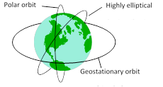
The orbit of such a satellite is known as sun-synchronous orbit. A remote sensing orbit can be circular polar orbit or in highly inclined elliptical orbit.
(3) A remote sensing satellite takes, photographs of a particular region which nearly the same illumination every time it passes through that region.
(4) The most useful remote sensing technology is that it makes possible the repetitive surveys of vast areas in a very short time, even if the areas are inaccessible.
(5) Space based remote sensing is a new technology. It has high potential for applications in nearly all aspects of resource management.
(6) The Indian remote sensing satellites are IRS-1A, JRS-1B, and IRS-1C.
(7) Some applications of remote sensing includes
(i) Meteorology : (development of weather systems and weather for casting).
(ii) Climatology : Monitoring climatic changes.
(iii) Oceanography : (Sea surface temperatures, mapping of sea-ice and oil pollution monitoring).
(iv) Archaeology, geological surveys.
(v) Water resource surveys,
(vi) Urban land use surveys.
(vii) Agriculture and forestry and natural disaster.
(viii) In the field of spying to detect movements of enemy army an their positions.
(ix) It is used to locate the place where under ground nuclear explosion has carried out.


You need to login to perform this action.
You will be redirected in
3 sec

