Category : UPSC
Hazards and Disaster Management
Introduction to Disaster Management
Objectives of this chapter
The main objective of this chapter is to have a basic understanding of various concepts used in disaster management. The concepts explained here are: Disaster, Hazard, Vulnerability, Capacity, Risk and Disaster Management Cycle. Apart from the terminologies, the chapter also tries to explain various types of disasters. After reading this chapter students will have a basic understanding about the concepts and should be able to differentiate between them with suitable examples.
Background
The global context
Disasters are as old as human history but the dramatic increase and the damage caused by them in the recent past have become because of national and international concern. Over the past decade, the number of natural and manmade disasters has climbed inexorably. From 1994 to 1998, reported disasters average was 428 per year but from 1999 to 2003, this figure went up to an average of 707 disaster events per year showing an increase of about 60% over the previous years. The biggest rise was in countries of low human development, which suffered an increase of 142%.
The figure A shows the deadliest disasters of the decade (1992-2001). Drought and famine have proved to be the deadliest disasters globally, followed by flood, technological disaster, earthquake, windstorm, extreme temperature and others. Global economic loss related to disaster events average around US $880 billion per year.
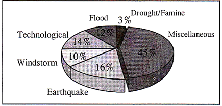
A World Scenario: Reported Deaths from all Disasters (1992-2001)
Indian scenario
The scenario in India is no different from the global context. The super cyclone of Orissa (1999), the Gujarat earthquake (2001) and the recent Tsunami (2004) affected millions across the country leaving behind a trail of heavy loss of life, property and livelihood. Table given below shows a list of some of the major disasters that have caused colossal impact on the community.
|
S. No. |
Disaster |
Impact |
|
|
Cyclone |
|
|
1. |
29, October, 1971 Odisha |
Cyclone and tidal waves killed 10,000 people |
|
2. |
19, November 1977, Andhra Pradesh |
Cyclone and tidal waves killed 20,000 people |
|
3. |
29th and 30th October, 1999, Odisha |
Cyclone and tidal waves killed 9,000 and 18 million people were affected |
|
|
Earthquake |
|
|
4. |
20th October, 1991, Uttarkashi |
An earthquake of magnitude 6.6 killed 723 people. |
|
5. |
30th September, 1993, Latur |
Approximately 8000 people died and there was heavy loss to infrastructure. |
|
6. |
22, May, 1997, Jabalpur |
39 people died. |
|
7. |
29th March 1997 |
Chamoli 100 people dead |
|
8. |
26th January, 2001 |
Bhuj, More than 10, 000 dead and heavy loss Gujarat to infrastructure |
|
|
Landslide |
|
|
9. |
July 1991, Assam |
300 people killed, heavy loss to roads and infrastructure |
|
10. |
August 1993 |
Nagaland 500 killed and more than 200 houses destroyed and about 5kms. Road damaged. |
|
11. |
18th August 1998, Malpa |
210 people killed. Villages were washed away |
|
|
Flood |
|
|
12. |
1978 Floods in North East India |
3,800 people killed and heavy loss to property. |
|
13. |
1997 Floods in Assam, Arunachal Pradesh, Jammu Kashmir, Himachal Pradesh, Punjab, Uttar Pradesh. Goa, Kerala and Gujarat. |
More than 2000 people killed and thousands affected |
While studying about the impact we need to be aware of potential hazards, how, when and where they are likely to occur, and the problems which may result of an event. In India, 59% of the land mass is susceptible to seismic hazard, 5% of the total geographical area is prone to floods; 8% of the total landmass is prone to cyclones; 70% of the total cultivable area is vulnerable to drought. Apart from this the hilly regions are vulnerable to avalanches/ landslides/hailstorms/cloudbursts. Apart from the natural hazards, we need to know about the other manmade hazards which are frequent and cause huge damage to life and property. It is therefore important that we are aware of how to cope with their effects. We have seen the huge loss to life, property and infrastructure a disaster can cause but let us understand what is a disaster, what are the factors that lead to it and its impact.
What is a Disaster?
Almost every day, newspapers, radio and television channels carry reports on disaster striking several parts of the world. But what is a disaster? The term disaster owes its origin to the French word "Disaster" which is a combination of two words 'des' meaning bad and 'aster' meaning star. Thus the term refers to ' Bad or Evil star'. A. disaster can be defined as "A serious disruption in the functioning of the community or a society causing wide spread material, economic, social or environmental losses which exceed the ability of the affected society to cope using its own resources". A disaster is a result from the combination of hazard, vulnerability and insufficient capacity or measures to reduce the potential chances of risk. A disaster happens when a hazard impacts on the vulnerable population and causes damage, casualties and disruption would give a better illustration of what a disaster is. Any hazard flood, earthquake or cyclone which is a triggering event along with greater vulnerability (inadequate access to resources, sick and old people, lack of awareness etc) would lead to disaster causing greater loss to life and property. For example; an earthquake in an uninhabited desert cannot be considered a disaster, no matter how strong the intensities produced
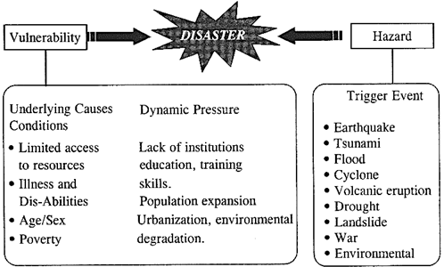
An earthquake is disastrous only when it affects people, their properties and activities. Thus, disaster occurs only when hazards and vulnerability meet. But it is also to be noted that with greater capacity of the individual/community and environment to face these disasters, the impact of a hazard reduces. Therefore, we need to understand the three major components namely hazard, vulnerability and capacity with suitable examples to have a basic understanding of disaster management.
What is a Hazard? How is it classified?
Hazard may be defined as "a dangerous condition or event, that threat or have the potential for causing injury to life or damage to property or the environment." The word 'hazard' owes its origin to the word 'hasard' in old French and 'az.-zahr' in Arabic meaning 'chance' or 'luck'. Hazards can be grouped into two broad categories namely natural and manmade.
Natural hazards are hazards which are caused because of natural phenomena (hazards with meteorological, geological or even biological origin). Examples of natural hazards are cyclones, tsunamis, earthquake and volcanic eruption which are exclusively of natural origin. Landslides, floods, drought, fires are socio-natural hazards since their causes are both natural and manmade. For example flooding may be caused because of heavy rains, landslide or blocking of drains with human waste.
Manmade hazards are hazards which are due to human negligence. Manmade hazards are associated with industries or energy generation facilities and include explosions, leakage of toxic waste, pollution, dam failure, wars or civil strife etc. The list of hazards is very long. Many occur frequently while others take place occasionally. However, on the basis of their genesis, they can be categorized as follows:
|
Types |
Types of Hazards |
Hazards |
|
Geological Hazards |
1. Earthquake 2. Tsunami 3. Volcanic Eruption |
4. Landslides 5. Dam Burst 6. Mine Fire |
|
Water & Climatic Hazards |
1. Tropical Cyclone 2. Tornado and hurricane 3. Flood 4. Drought 5. Hailstorm |
6. Cloud Best 7. Landslide 8. Heat and Cold Wave 9. Snow Avalanche 10. Sea Erosion |
|
Environmental Hazards Biological |
1. Environmental Pollution 2. Deforestation 1. Human/Animal Epidemics 2. Pest Attacks |
3. Desertification 4. Pest Infection 3. Food Poisoning 4. Weapons of mass destruction. |
|
Chemical, Industrial and Nuclear Accidents |
· Chemical disasters · Nuclear disasters |
· Oil Spills/Fires · Nuclear |
|
Accident Related |
Transportation Urban fires bomb blast/Forest fires |
· Building collapse · Electrical accidents · Festival related disasters |
What is vulnerability?
Vulnerability may be defined as "The extent to which a community, structure, services or geographic area is likely to be damaged or disrupted by the impact of particular hazard, on account of their nature, construction and proximity to hazardous terrains or a disaster prone area." Vulnerabilities can be categorized into physical and socio-economic vulnerability.
Physical Vulnerability
It includes notions of whom and what may be damaged or destroyed by natural hazard such as earthquakes or floods.
It is based on the physical condition of people and elements at risk, such as buildings, infrastructure etc; and their proximity, location and nature of the hazard. It also relates to the technical capability of building and structures to resist the forces acting upon them during a hazard event. Unchecked growth of settlements in unsafe areas exposes the people to the hazard. In case of an earthquake or landslide the ground may fail and the houses on the top may topple or slide and affect the settlements at the lower level even if they are designed well for earthquake forces.
Socio-economic Vulnerability
The degree to which a population is affected by a hazard will not merely lie in the physical components of vulnerability but also on the socioeconomic conditions. The socio-economic condition of the people also determines the intensity of the impact. For example, people who are poor and living in the sea coast don't have the money to construct strong concrete houses. They are generally at risk and lose their shelters whenever there is strong wind or cyclone. Because of their poverty they too are not able to rebuild their houses.
What is capacity?
Capacity can be defined as "resources, means and strengths which exist in households and communities and which enable them to cope with, withstand, prepare for, prevent, mitigate or quickly recover from a disaster". People's capacity can also be taken into account. Capacities could be:
Physical Capacity
People whose houses have been destroyed by the cyclone or crops have been destroyed by the flood can salvage things from their homes and from their farms. Some family members have skills, which enable them to find employment if they migrate, either temporarily or permanently.
Socio-economic Capacity
In most of the disasters, people suffer their greatest losses in the physical and material realm. Rich people have the capacity to recover soon because of their wealth. In fact, they are seldom hit by disasters because they live in safe areas and their houses are built with stronger materials. However, even when everything is destroyed they have the capacity to cope up with it. Hazards are always prevalent, but the hazard becomes a disaster only when there is greater vulnerability and less of capacity to cope with it. In other words the frequency or likelihood of a hazard and the vulnerability of the community increases the risk of being severely affected.
What is risk?
Risk is a "measure of the expected losses due to a hazard event occurring in a given area over a specific time period. Risk is a function of the probability of particular hazardous event and the losses each would cause." The level of risk depends upon:
|
Disaster Bisk Reduction can take place in the followings ways: 1. Preparedness: This protective process embraces measures which enable governments, communities and individuals to respond rapidly to disaster situations to cope with them effectively. Preparedness includes the formulation of viable emergency plans, the development of warning systems, the maintenance of inventories and the training of personnel. It may also embrace search and rescue measures as well as evacuation plans for areas that may be at risk from a recurring disaster. Preparedness therefore encompasses those measures taken before a disaster event which are aimed at minimizing loss of life, disruption of critical services, and damage when the disaster occurs. 2. Mitigation: Mitigation embraces measures taken to reduce both the effect of the hazard and the vulnerable precautions to it in order to reduce the scale of a future disaster. Therefore mitigation activities can be focused on the hazard itself or the elements exposed to the threat. Examples of mitigation measures which are hazard specific include water management in drought prone areas, relocating people away from the hazard prone areas and by strengthening structures to reduce damage when a hazard occurs. In addition to these physical measures, mitigation should also aim at reducing the economic and social vulnerabilities of potential disasters. |
Disaster Risk Management
Disaster Risk Management includes sum total of all activities, programmes and measures which can be taken up before, during and after a disaster with the purpose to avoid a disaster, reduce its impact or recover from its losses. The three key stages of activities that are taken up within disaster risk management are:
Activities taken to reduce human and property losses caused by a potential hazard. For example carrying out awareness campaigns, strengthening the existing weak structures, preparation of the disaster management plans at household and community level, etc. Such risk reduction measures taken under this stage are termed as mitigation and preparedness activities.
Initiatives taken to ensure that the needs and provisions of victims are met and suffering is minimized. Activities taken under this stage are called emergency response activities.
Initiatives taken in response to a disaster with a purpose to achieve early recovery and rehabilitation of affected communities, immediately after a disaster strikes. These are called as response and recovery activities.
Types of Disasters Management
There are two types of disasters Management
(a) Natural disaster/Hazard Management
(b) Anthropogenic Disaster/Hazard Management
Natural Disaster Hazard Management
Natural Hazards is devoted to original research work on all aspects of natural hazards, including the forecasting of catastrophic events, risk management, and the nature of precursors of natural and technological hazards. Although hazards can originate in different sources and systems, such as atmospheric, hydrologic, oceanographic, volcano logic, seismic, geotectonic, the environmental impacts are equally catastrophic. This warrants a close interaction between different scientific and operational disciplines, aimed at enhancing the mitigation of hazards. Coverage includes such categories of hazard as atmospheric, climatologic, oceanographic, storm surges, tsunamis, floods, snow, avalanches, landslides, erosion, earthquakes, volcanoes, man-made and technological, as well as risk assessment. The natural disasters hazards and their risk managements are given below:
Earthquake & Its, Risk. Management
An earthquake (also known as a quake, tremor or temblor) is the shaking of the surface of the Earth, resulting from the sudden release of energy in the Earth's lithosphere that creates seismic waves. Earthquakes can range in size from those that are so weak that they cannot be felt to those violent enough to toss people around and destroy whole cities. The seismicity or seismic activity of an area refers to the frequency, type and size of earthquakes experienced over a period of time. Earthquake are measured using measurements from seismometers. The moment magnitude is the most common scale on which earthquakes larger than approximately 5 are reported for the entire globe. The more numerous earthquakes smaller the magnitude 5 reported by national seismological observatories are measured mostly on the local magnitude scale, also referred to as the Richter magnitude scale. These two scales are numerically similar over their range of validity. Magnitude 3 or lower earthquakes are mostly imperceptible or weak and magnitude 7 and over potentially causes serious damage over larger areas, depending on their depth. The largest earthquakes in historic times have been of magnitude slightly over 9, although there is no limit to the possible magnitude. Intensity of shaking is measured on the modified Mercalli scale. The shallower an earthquake, the more damage to structures it causes, all else being equal.
Naturally Occurring Earthquakes
Tectonic earthquakes occur anywhere in the earth where there is sufficient stored elastic strain energy to drive fracture propagation along a fault plane. The sides of a fault move past each other smoothly and a-seismically only if there are no irregularities or asperities along the fault surface that increase the frictional resistance. Most fault surfaces do have such asperities and this leads to a form of stick-slip behavior. Once the fault has locked, continued relative motion between the plates leads to increasing stress and therefore, stored strain energy in the volume around the fault surface. This continues until the stress has risen sufficiently to break through the asperity, suddenly allowing sliding over the locked portion of the fault, releasing the stored energy.
This energy is released as a combination of radiated elastic strain seismic waves, frictional heating of the fault surface, and cracking of the rock, thus causing an earthquake. This process of gradual build-up of strain and stress punctuated by occasional sudden earthquake failure is referred to as elastic-rebound theory. It is estimated that only 10% or less of an earthquake's total energy is radiated as seismic energy. Most of the earthquake's energy is used to power the earthquake fracture growth or is converted into heat generated by friction. Therefore, earthquakes lower the Earth's available elastic potential energy and raise its temperature, though these changes are negligible compared to the conductive and convective flow of heat out from the Earth's deep interior.
Earthquakes and volcanic activity
Earthquakes often occur in volcanic regions and are caused there, both by tectonic faults and the movement of magma in volcanoes. Such earthquakes can serve as an early warning of volcanic eruptions, as during the 1980 eruption of Mount St. Helens. Earthquake swarms can serve as markers for the location of the flowing magma throughout the volcanoes. These swarms can be recorded by seismometers and telemeters (a device that measures ground slope) and used as sensors to predict imminent or upcoming eruptions.
Cause of Earthquake
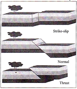
The earth's crust is a rocky layer of varying thickness ranging from a depth of about 10 kilometers under the sea to 65 kilometers under the continents. The crust is not one piece but consists of portions called 'plates' which vary in size from a few hundred to thousands of kilometers. The 'theory of plate tectonics' holds that the plates ride up on the more mobile mantle, and are driven by some yet unconfirmed mechanisms, perhaps thermal convection currents. When these plates contact each other, stress arises in the crust. These stresses can be classified according to the type of movement along the plate's boundaries:
(a) Pulling away from each other,
(b) Pushing against one another and
(c) Sliding sideways relative to each other. All these movements are associated with earthquakes.
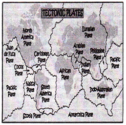
Tectonic Plates
Seven major plates and several minor ones- they move a few inches a year, riding on semi-molten layers of rock underneath the crust.

Tectonic Plates
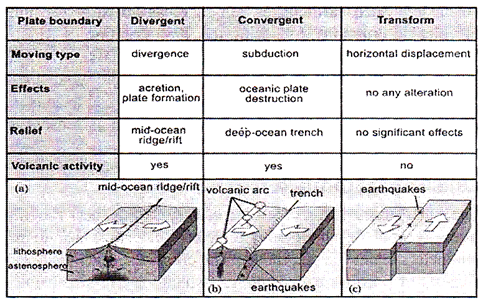
Different types of plate movement


The areas of stress at plate boundaries which release accumulated energy by slipping or rupturing are known as 'faults'. The theory of 'elasticity' says that the crust is continuously stressed by the movement of the tectonic plates; it eventually reaches a point of maximum supportable strain. A rupture then occurs along the fault and the rock rebounds under its own elastic stresses until the strain is relieved. The fault rupture generates vibration called seismic (from the Greek 'seismos' meaning shock or earthquake) waves, which radiates from the focus in all directions. The point of rupture is called the 'focus' and may be located near the surface or deep below it.
The point on the surface directly above the focus is termed as the 'epicenter' of the earthquake.

General characteristics
Earthquake vibrations occur in a variety of frequencies and velocities. The actual rupture process may last for a few seconds to as long as one minute for a major earthquake. The ground shaking is caused by 'body waves' and 'surface wave'.
|
Body waves (P and S waves) penetrate the body of the earth, vibrating fast. 'P' waves travel about 6 kilometers per hour and 'S' waves travel with a speed of 4 kilometers per hour. Surface waves vibrate the ground horizontally and vertically. These long period waves cause swaying of tall buildings and slight waves motion in bodies of water even at great distances from the epicenter. |
Earthquakes can be of three types based on the focal depth:
Measuring and locating Earthquakes
The instrumental scales used to describe the size of an earthquake began with the Richter magnitude scale in the 1930s. It is a relatively simple measurement of an event's amplitude, and its use has become minimal in the 21st century. Seismic waves travel through the Earth's interior and can be recorded by seismometers at great distances. The surface wave magnitude was developed in the 1950s as a means to measure remote earthquakes and to improve the accuracy for larger events. The moment magnitude scale measures the amplitude of the shock, but also takes into account the seismic moment (total rupture area, average slip of the fault, and rigidity of the rock). The Japan Meteorological Agency seismic intensity scale, the Medvedev-Sponheuer-Karnik scale, and the Mercalli intensity scale are based on the observed effects.
Every tremor produces different types of seismic waves, which travel through rock with different velocities:
Predictability: Although some scientists claim ability to predict earthquakes, the methods are controversial. Accurate and exact predictions of such sudden incidents are still not possible.
Typical adverse effects
Physical damage
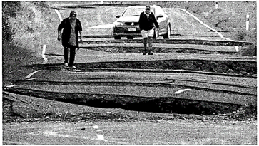
Damage occurs to human settlement, buildings, structures and infrastructure, especially bridges, elevated roads, railways, water towers, pipelines, electrical generating facilities' Aftershocks of an earthquake can cause much greater carnage to already weakened structures. Secondary effects include fires, dam failure and landslides which may block water ways and also cause flooding. Damage may occur to facilities using or manufacturing dangerous materials resulting in possible chemical spills. There may also be a breakdown of communication facilities. The effect of an earthquake is diverse. There are large number of casualties because of the poor engineering design of the buildings and close proximity of the people. About 95% of the people who are killed or who are affected by the earthquake is because of the building collapse. There is also a huge loss to the public health system, transport and communication and water supply in the affected areas.
Distribution pattern of Earthquakes in India
India falls quite prominently on the 'Alpine - Himalayan Belt'. This belt is the line along which the Indian plate meets the Eurasian plate. This being a convergent plate, the Indian plate is thrusting underneath the Eurasian plate at a speed of 5 cm per year. The movement gives rise to tremendous stress which keeps accumulating in the rocks and is released from time to time in the form of earthquakes.
The seismic zoning map of India is divided into four zones namely Zone II, III, IV and V, with zone V shown in above figure being most vulnerable to earthquakes. Much of India lies in zone III. New Delhi the capital city of India lies in zone IV where as big cities like Mumbai and Chennai are in zone III.

Seismic zonation and intensity map of India
List of significant Earthquakes in India.
|
Year |
Location |
Magnitude |
|
1950 |
Arunachal Pradesh- China Border |
8.5 |
|
1956 |
Anja, Gujrat |
7.0 |
|
1967 |
Koyna, Maharashtra |
6.5 |
|
1975 |
Kinnaur-Himachal Pradesh |
6.2 |
|
1988 |
Manipur-Myanmar Border |
6.6 |
|
1988 |
Bihar-Nepal Border |
6.4 |
|
1991 |
Uttarkashi-Uttar Pradesh Hills |
6.0 |
|
1993 |
Latur-Maharashtra |
6.3 |
|
1997 |
Jabalpur, Madhya Pradesh |
6.0 |
|
1999 |
Chamoli, Himachal Pradesh |
6.8 |
|
2001 |
Bhuj, Gujrat |
6.9 |
|
2005 |
Muzaffarabad (Pakistan) impact in J & K |
7.4 |
|
2015 |
Nepal impact in different parts of India (Delhi, Bihar, Uttar Pradesh, Rajasthan) |
7.8. |
Possible risk reduction measures
Community preparedness
Community preparedness is vital for mitigating earthquake impact. The most effective way to save you even in a slightest shaking is 'DROP, COVER and HOLD'.
Planning
The Bureau of Indian Standards has published building codes and guidelines for safe construction of buildings against earthquakes. Before the buildings are constructed the building plans have to be checked by the Municipality, according to the laid down bylaws. Many existing lifeline buildings such as hospitals, schools and fire stations may not be built with earthquake safety measures. Their earthquake safety needs to be upgraded by retrofitting techniques.
Public education
Public education is educating the public on causes and characteristics of an earthquake and preparedness measures. It can be created through sensitization and training programme for community, architects, engineers, builders, masons, teachers, government functionaries teachers and students. Engineered structures: Buildings need to be designed and constructed as per the building by laws to withstand ground shaking. Architectural and engineering inputs need to be put together to improve building design and construction practices. The soil type needs to be analyzed before construction. Building structures on soft soil should be avoided. Buildings on soft soil are more likely to get damaged even if the magnitude of the earthquake is not strong as shown in Figure. Similar problems persist in the buildings constructed on the river banks which have alluvial soil.
Tsunami
The term Tsunami has been derived from a Japanese term 'Tsu' meaning 'harbor' and 'nami' meaning 'waves'. Tsunamis are popularly called tidal waves but they actually have nothing to do with the tides. These waves which often affect distant shores, originate by rapid displacement of water from the lake or the sea either by seismic activity, landslides, volcanic eruptions or large meteoroid impacts. Whatever the cause may be sea water is displaced with a violent motion and swells up, ultimately surging over land with great destructive power. The effects of a tsunami can be unnoticeable or even destructive.
Causes of a Tsunami
The geological movements that cause tsunamis are produced in three major ways. The most common of these are fault movements on the sea floor, accompanied by an earth-quake. They release huge amount of energy and have the capacity to cross oceans. The degree of movement depends on how fast the earthquake occurs and how much water is displaced. Fig shows how an earthquake causes tsunami. The second most common cause of the tsunami is a landslide either occurring under water or originating above the sea and then plunging into the water. The largest tsunami ever produced by a landslide was in Lituya
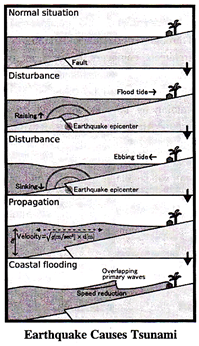
Bay, Alaska 1958. The massive rock slide produced a wave that reached a high water mark of 50 - 150 meters above the shoreline. The third major cause of tsunami is volcanic activity. The flank of a volcano located near the shore or under water may be uplifted or depressed similar to the action of a fault, or, the volcano may actually explode. In 1883, the violent explosion of the famous volcano, Krakotoa in Indonesia, produced tsunami measuring 40 meters which crushed upon Java and Sumatra. Over 36,000 people lost their lives in this tyrant waves.
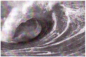
Picture of a Tsunami Wave
General Characteristics
Tsunami differs from ordinary ocean waves, which are produced by wind blowing over water. The tsunamis travel much faster than ordinary waves. Compared to normal wave speed of 100 kilometers per hour, tsunami in the deep water of the ocean may travel the speed of a jet airplane - 800 kilometers per hour! And yet, in spite of their speed, tsunami increases the water height only 30-45cm and often passes unnoticed by ships at sea. Contrary to the popular belief, the tsunami is not a single giant wave. It is possible for a tsunami to consist of tea or more waves which is then termed as 'tsunami wave train". The waves follow each other 5 to 90 minutes apart. Tsunami normally causes flooding as a huge wall of water enters the main land.
Predictability
There are two distinct types of tsunami warning:
(a) International tsunami warning systems and
(b) Regional warning systems.
Tsunamis have occurred in all the oceans and in the Mediterranean Sea, but the great majority of them have occurred in the Pacific Ocean. Since scientists cannot exactly predict earthquakes, they also cannot exactly predict when a tsunami will be generated.
(a) International Tsunami Warning Systems
Shortly after the Hilo Tsunami (1946), the Pacific Tsunami Warning System (PTWS) was developed with its operational center at the Pacific Tsunami Warning Center (PTWC) near Honolulu, Hawaii. The PTWC is able to alert countries several hours before the tsunami strikes.
The warning includes predicted arrival time at selected coastal communities where the tsunami could travel few hours. A tsunami watch is issued with subsequent arrival time to other geographic areas.
(b) Regional Warning Systems
Usually use seismic data about nearby earthquakes to determine if there is a possible local threat of a tsunami. Such systems are capable enough to provide warnings to the general public in less than 15 minutes.
In India, the Survey of India maintains a tide gauge network along the coast of India.
|
In 1995 the Us National Oceanic and Atmospheric Administration (NOAA) began developing the Deep Ocean Assessment and Reporting of Tsunami (DART) system. By 2001 six stations had been deployed in the Pacific Ocean. Each station consists of a sea bed bottom pressure recorder (at a depth of about 6000m) which detects the passage of a tsunami and transmits the data to a surface buoy. The surface buoy then radios the information to the PTWC. |
The gauges are located in major ports as shown in the figure below the day-to-day maintenance of the gauge is carried with the assistance from authorities of the ports.

Tidal Gauge in India
Apart from the tide gauge, tsunami can be detected with the help of radars. The 2004 Indian Ocean tsunami, recorded data from four radars and recorded the height of tsunami waves two hours after the earthquake. It should be noted that the satellites observations of the Indian Ocean tsunami would not have been of any use in delivering warnings, as the data took five hours to process and it was pure chance that the satellites were overhead at that time. However, in future it is possible that the space-based observation might play a direct role in tsunami warning.
Typical adverse effects
Local tsunami events or those less than 30 minutes from the source cause the majority of damage. The force of the water can raze everything in its path. It is normally the flooding affect of the tsunami that causes major destruction to the human settlements, roads and infrastructure thereby disrupting the normal functioning of the society. Withdrawal of the tsunami causes major damage. As the waves withdraw towards the ocean they sweep out the foundations of the buildings, the beaches get destroyed and the houses carried out to sea. Damage to ports and airports may prevent importation of needed food and medical supplies. Apart from the physical Damage, there is a huge impact on the public health system. Deaths mainly occur because of drowning as water inundates homes. Many people get washed away or crushed by the giant waves and some are crushed by the debris. There are very few evidences which show that tsunami flooding has caused large scale health problem. Availability of drinking water has always been a major problem in areas affected by a disaster. Sewage pipes may be damaged causing major sewage disposal problems. Open wells and other ground water may be contaminated by salt water and debris and sewage. Flooding in the locality may lead to crop loss, loss of livelihood like boats and nets, environmental degradation, etc.
Distribution pattern of Tsunami in India
Even though India has not faced frequent Tsunamis but there is a need to identify the areas that are generally affected by Tsunamis. The whole of the Indian coastal belt is prone to Tsunami.
Possible risk reduction measures
While it is of course not possible to prevent a tsunami, in certaintsunami prone countries some measures have been taken to reduce the damage caused on shore. Japan has implementedan extensive programme of building tsunami walls of up to4.5m (13.5 ft) high in front of populated coastal areas. Otherlocalities have built flood gates and channels to redirect thewater from incoming tsunamis. However, their effectivenesshas been questioned, as tsunamis are often higher than thebarriers. For instance, the tsunami which hit the island ofHokkaido on July 12, 1993 created waves as much as 30m(100 ft) tall - as high as a 10-story building. The port town ofAonae on Hokkaido was completely surrounded by a tsunamiwall, but the waves washed right over the wall and destroyedall the wood framed structures in the area.
Site Planning and Land Management
Within the broader framework of a comprehensive plan, site planning determines the location, configuration, and density of development on particular sites and is, therefore, an important tool in reducing tsunami risk. In areas where it is not feasible to restrict land to open-space uses; other land use planning measures can be used. These include strategically controlling the type of development and uses allowed in hazard areas, and avoiding high-value and high occupancy uses to the greatest degree possible.
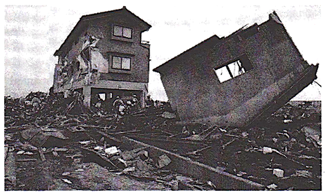
Damaged houses constructed on the sea coast
Engineering structures
Most of the habitation of the fishing community is seen in the coastal areas. The houses constructed by them are mainly of lightweight materials without any engineering inputs. Therefore there is an urgent need to educate the community about the good construction practices that they should adopt such as:
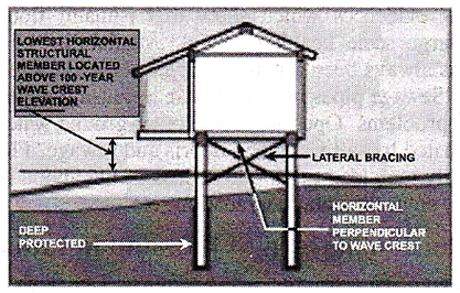
Design solution by Tsunami effect
Flood management -
Flooding will result from a tsunami. Tsunami waves will flood the coastal areas. Flood mitigation measures could be incorporated.
Cyclone
Cyclone is a region of low atmospheric pressure surrounded by high atmospheric pressure resulting in swirling atmospheric disturbance accompanied by powerful winds blowing in anticlockwise direction in the Northern Hemisphere and in the clockwise direction in the Southern Hemisphere. They occur mainly in the tropical and temperate regions of the world. Cyclones are called by various names in different parts of the world as mentioned in box.
General Characteristics
Cyclones in India are moderate in nature. Some of the general characteristics of a cyclone are:
|
Cyclones are known by different names in different parts of the world: · Typhoons: in the Northwest Pacific Ocean west of the dateline · Hurricanes: in the North Atlantic Ocean, the Northeast Pacific Ocean of the dateline, or the South Pacific Ocean. · Tropical cyclones: the Southwest Pacific Ocean and Southeast Indian Ocean. · Severe cyclone storm? (the North Indian Ocean) · Tropical cyclone (the Southwest Indian Ocean) · Willie-Willie in Australia · Tornado in South America |
Cyclone in Odisha (1999)
29th October 1999, Super-cyclone with wind speed of 260-300 km/hour hit the 140 kilometer coast of Orissa with a storm surge created in the Bay-of-Bengal with water level 9 metres higher than normal. The super storm travelled more than 250 km inland and within a period of 36 hrs ravaged more than 200 lakh hectares of land, devouring trees and vegetation, leaving behind a huge trail of destruction.
Stages of a Wave Cyclone
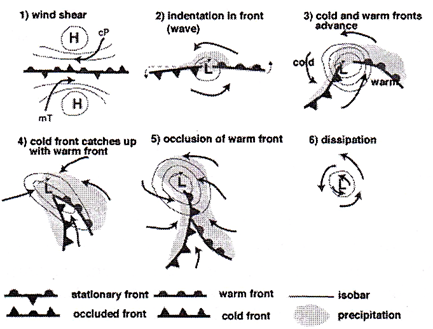
The violent cyclone was merciless and broke the backbone of Orissa's economy and killed thousands and devastated millions. The development of a cyclone covers three stages namely:
(a) Formation and initial development state
Four atmospheric/ oceanic conditions are necessary for the formation of a cyclone namely:
Formation of Cyclone
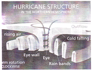
(b) Fully matured
The main feature of a fully mature tropical cyclone is a spiral pattern of highly turbulent giant cumulus thundercloud bands. These bands spiral inwards and form a dense highly active central cloud core which raps around a relatively calm zone. This is called the "eye" of a cyclone. The eye looks like a black hole or a dot surrounded by thick clouds. The outer circumference of the thick cloud is called the ‘eye wall’.
(c) Weakening or decay
A tropical cyclone begins to weaken as soon as its source of warm moist air is abruptly cut off. This is possible when the cyclone hits the land, on the cyclone moves to a higher altitude or when there is the interference of another low pressure. Depending on their track on the warm tropical sea and proximity to land a cyclone may last for less than 24 hours to more than 3 weeks.
(d) On an average the life cycle of a cyclone (a cyclone to complete these three stages mentioned above) takes six days. The longest cyclone is typhoon John which lasted for 31 days (August to September, 1994 in the north east and north west pacific basins).
Indian Cyclones
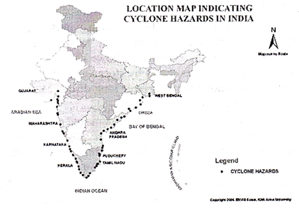
Cyclones vary in frequency in various parts of the world. The 7516.6 kilometers long Indian coastline is the earth's most cyclone battered stretch of the world. Around 8% of the total land area in India is prone to cyclones. About two-third of the of clones that occur in the Indian coastline occur in the Bay of Bengal. The states which are generally affected in the east coast are West-Bengal, Orissa, Andhra Pradesh; Tamil Nadu ad on the west coast Gujarat, Maharashtra, Goa, Karnataka and Kerala.
Distributional Pattern
The map of India shows the areas that are generally affected by strong winds/ cyclones. Some of the major cyclones that have affected the country in the past are as mentioned in table given below.
|
S. No. |
Year |
Area |
Death Toll |
|
1 |
1971 |
Eastern Coast |
9658 |
|
2 |
1972 |
Andhra Pradesh and Orissa |
100 |
|
3 |
1977 |
Chennai, Kerala & Andhra Pradesh |
14,204 |
|
4 |
1979 |
Andhra Pradesh |
594 |
|
5 |
1981 |
Gujarat |
470 |
|
6 |
1982 |
Gujarat & Maharashtra |
500 |
|
7 |
1984 |
Tamil Nadu & Andhra Pradesh |
512 |
|
8 |
1985 |
Andhra Pradesh |
5000 |
|
9 |
1990 |
Andhra Pradesh |
957 |
|
10 |
1990 |
Orissa |
250 |
|
11 |
1999 |
Orissa |
8913 |
Warning
Low pressure and the development can be detected hours or days before it causes damage. The satellites track the movement of these cyclones based on which the people are evacuated from areas likely to be affected. It is difficult to predict the accuracy. Accurate landfall predictions can give only a few hours' notice to threatened population. India has one of the best cyclone warning systems in the world. The India Meteorological Department (IMD) is the nodal department for wind detection, tracking and forecasting cyclones.
Cyclone tracking is done through INSAT satellite. Cyclone warning is disseminated by several means such as satellite based disaster warning systems, radio, television, telephone, fax, high priority telegram, public announcements and bulletins in press. These warnings are disseminated to the general public, the fishing community especially those in the sea, port authorities, commercial aviation and the government machinery.
Elements at Risk
Strong winds, torrential rains and flooding cause a huge loss to life and property. The 1999 Super Cyclone of Orissa killed more than 10,000 precious lives with women and children greatly affected. Apart from loss to life there is a huge loss to infrastructures like houses built of mud, older buildings with weak walls, bridges, settlements in low lying areas.
Typical Adverse effect
First, in a sudden, brief onslaught, high winds cause major damage to infrastructure and housing, in particular fragile constructions. They are generally followed by heavy rains and floods and, in flat coastal areas by storm surge riding on tidal waves and inundating the land over long distances of even up to 15 kilometer inland.
Physical damage - structures will be damaged or destroyed by the wind force, flooding and storm surge. Light pitched roofs of most structures especially the ones fitted on to industrial buildings will suffer severe damage.
Casualties and public heath - caused by flooding and flying elements, contamination of water supplies may lead to viral outbreaks, diarrhea, and malaria.
Water supplies - Ground and pipe water supply may get contaminated by flood waters.
Crops and food supplies - high winds and rains ruin the standing crop and food stock lying in low lying areas. Plantation type crops such as banana and coconut are extremely vulnerable. Salt from the sea water may get deposited on the agricultural land and increase the salinity. The loss of the crop may lead to acute food shortage.
Communication - severe disruption in the communication links as the wind may bring down the electricity and communication towers, telephone poles, telephone lines, antennas and satellite disk and broadcasting services. Transport lines (road and rail) may be curtailed. Lack of proper communication affects effective distribution of relief materials.
Possible Risk Reduction Measures
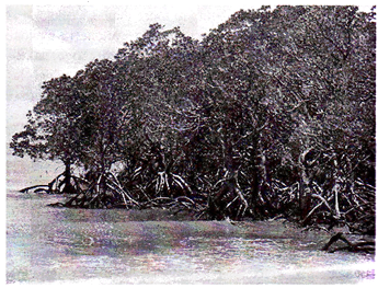
Coastal belt plantation - green belt plantation along the coastal line in a scientific interweaving pattern can reduce the effect of the hazard. Providing a cover through green belt sustains less damage. Forests act as a wide buffer zone against strong winds and flash floods. Without the forest the cyclone travel freely inland. The lack of protective forest cover allows water to inundate large areas and cause destruction. With the loss of the forest cover each consecutive cyclone can penetrate further inland. Cyclones can be predicted several days in advance. The map is prepared with data inputs of past climatological records, history of wind speed, frequency of flooding etc.
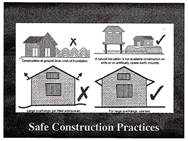
Land use control designed so that least critical activities are placed in vulnerable areas. Location of settlements in the floodplains is at utmost risk. Majority of the buildings in coastal areas are built with locally available materials and have no engineering inputs. Good construction practice should be adopted such as:
- Cyclonic wind storms inundate the coastal areas. It is advised to construct on stilts or on earth mound. - Houses can be strengthened to resist wind and flood damage. All elements holding the structures need to be properly anchored to resist the uplift or flying off of the objects. For example, avoid large overhangs of roofs, and the projections should be tied down.
- A row of planted trees will act as a shield. It reduces the energy.
- Buildings should be wind and water resistant.
- Buildings storing food supplies must be protected against the winds and water.
-Protect river embankments. Communication lines should be installed underground.
Flood management - Torrential rains, strong wind and storm range leads to flooding in the cyclone affected areas. There are possibilities of landslides too. Flood mitigation measures could be incorporated (see section on floods for additional information).
Improving vegetation cover - The roots of the plants and trees keep the soil intact and prevent erosion and slow runoff to prevent or lessen flooding. The use of tree planted in rows will act as a windbreak. Coastal shelterbelt plantations can be developed to break severe wind speeds. It minimizes devastating effects. The Orissa calamity has also highlighted the need for urgent measures like shelterbelt plantation along cyclone-prone coastal areas. Species chosen for this purpose should not only be able to withstand the impact of strong cyclonic winds, but also check soil erosion.
Flood
Flood is a state of high water level along a river channel or the coast that leads to inundation of land, which is not usually submerged. Floods may happen gradually and also may take hours or even happen suddenly without any warning due to breach in the embankment, spill over, heavy rains etc.
There are different types of floods namely: flash flood, riverine flood, urban flood, etc. Flash floods can be defined as floods which occur within six hours of the beginning of heavy rainfall, and are usually associated with cloud bursts, storms and cyclones requiring rapid localized warnings and immediate response to reduce damage. Wireless network and telephone connections are used to monitor flood conditions. In case of flash floods, warnings for timely evacuation may not always be possible.
Causes
There are several causes of floods and differ from region to region. The causes may vary from a rural area to an urban area. Some of the major causes are:
(a) Heavy rainfall
(b) Heavy siltation of the river bed reduces the water carrying capacity of the rivers/stream.
(c) Blockage in the drains leads to flooding of the area.
(d) Landslides blocking the flow of the stream.
(e) Construction of dams and reservoirs
(f) In areas prone to cyclone, strong winds accompanied by heavy down pour along with storm surge leads to flooding.
Adverse Effects
The most important consequence of floods is the loss of life and property. Structures like houses, bridges; roads etc. get damaged by the gushing water, landslides triggered on account of water getting saturated, boats and fishing nets get damaged. There is huge loss to life and livestock caused by drowning. Lack of proper drinking water facilities, contamination of water (well, ground water, piped water supply) leads to outbreak of epidemics, diarrhea, viral infection, malaria and many other infectious diseases. Flooding also leads to a large area of agricultural land getting inundated as a result there is a huge crop loss. This results in shortage of food, and animal fodder. Floods may also affect the soil characteristics. The land may be rendered infertile due to erosion of top layer or may mm saline if sea water floods the area.
Distributional Pattern of floods in India
Floods occur in almost all the river basins of the country. The vulnerability Atlas of India shows pictorially the areas liable to floods. Around 12% (40 million hectare) of land in India is prone to floods. Map showing Flood Zones in India Most of the flood affected areas lie in the Ganga basin, Brahmaputra basin (comprising ofBarak, Tista, Torsa, Subansiri, Sankosh, Dihang and Luhit), the northwestern river basin (comprising Jhelum, Chenab, Ravi, Sutlej, Beas and the Ghagra), peninsular river basin (Tapti, Narmada, Mahanadi, Baitarani, Godavari, krishna, Pennar and the Kaveri) and the coastal regions of Andhra Pradesh, Tamilnadu, orissa and Kerela. Assam, Uttar Pradesh, Bihar and Orissa are some of the states who have been severely prone to floods. Our country receives an annual rainfall of 1200 mm, 85 % of which is concentrated in 3-4 months i.e. June to September. Due to the intense and periodic rain, most of the rivers of the country are fed with huge quantity of' water, much beyond their carrying capacity.
Warming
Flood forecasting and warning has been highly developed in the past two decades. With the advancement of technology such as satellite and remote-sensing equipments flood waves can be tracked the water level rises. Except for flash floods there is usually a reasonable warning period. Heavy precipitation will give sufficient warning of the coming river flood. High tides with high winds may indicate flooding in the coastal areas. Evacuation is possible with suitable monitoring and warning. Warning is issued by the Central Water Commission (CWC), Irrigation & Flood Control Department, and Water Resources Department. CWC maintains close liaison with the administrative and state engineering agencies, local civil authorities to communicate advance warning for appropriate mitigation and preparedness measures.
Risk Reduction Measures
Mapping of the flood prone areas is a primary step involved in reducing the risk of the region. Historical records give the indication of the flood inundation areas and the period of occurrence and the extent of the coverage. Warning can be issued looking into the earlier marked heights of the water levels in case of potential threat. In the coastal areas the tide levels and the land characteristics will determine the submergence areas. Flood hazard mapping will give the proper indication of water flow during floods.
Land use control will reduce danger of life and property when waters inundate the floodplains and the coastal areas. In areas where people already have built their settlements, measures should be taken to relocate to better sites so as to reduce vulnerability. No major development should be permitted in the areas which are subjected to high flooding.
Construction of engineered structures in the flood plains and strengthening of structures to withstand flood forces and seepage. The buildings should be constructed on an elevated area. If necessary build on stilts or platform.
Flood Control aims to reduce flood damage. This can be done by decreasing the amount of run off with the help of reforestation (to increase absorption could be a mitigation strategy in certain areas), protection of vegetation, clearing of debris from streams and other water holding areas, conservation of ponds and lakes etc. Flood Diversion includes levees, embankments, dams and channel improvement. Dams can store water and can release water at a manageable rate. But failure of dams in earthquakes and operation of releasing the water can cause floods in the lower areas. Flood Proofing reduces the risk of damage. Measures include use of sand bags to keep flood water away, blocking or sealing of doors and windows of houses etc. Houses may be elevated by building on raised land. Buildings should be constructed away from water bodies.
Benefits
Floods (in particular more frequent or smaller floods) can also bring many benefits, such as recharging ground water, making soil more fertile and increasing nutrients in some soils. Flood waters provide much needed water resources in arid and semi-arid regions where precipitation can be very unevenly distributed throughout the year and kills pests in the farming land. Freshwater floods particularly play an important role in maintaining ecosystems in river corridors and are a key factor in maintaining floodplain biodiversity. Flooding can spread nutrients to lakes and rivers, which can lead to increased biomass and improved fisheries for a few years.
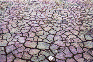
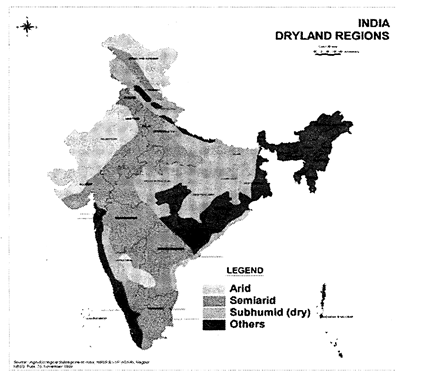
Drought
Drought is either absence or deficiency of rainfall from its normal pattern in a region for an extended period of time leading to general suffering in the society. It is interplay between demand that people place on natural supply of water and natural event that provides the water in a given geographical region. The state of Kerala which receives more than 3000 mm of rainfall every year is declared drought affected as it is insufficient to have two good crops. The more the imbalance in supply the higher is the drought. The following will help explaining this general definition of the drought further.
Causes of Drought
Though drought is basically caused by deficit rainfall, which is a meteorological phenomenon, it manifests into different spheres because of various vulnerability factors associated with them (see the box). Some of these factors are human induced. Though drought is a natural disaster, its effects are made worst in developing countries by over population, over grazing, deforestation, soil erosion, excessive use of ground and surface water for growing crops, loss of biodiversity.
General Characteristics
Types of droughts Drought proceeds in sequential manner. Its impacts are spread across different domains as listed below.
Meteorological drought: Meteorological drought is simple absence/deficit of rainfall from the normal. It is the least severe form of drought and is often identified by sunny days and hot weather.
Hydrological drought: Hydrological drought often leads to reduction of natural stream flows or ground water levels, plus stored water supplies. The main impact is on water resource systems.
|
What on earth do you know about water? · Approximately 71% of earth's surface is covered with water but only 1 % of it is fresh water that we can use. · About 2.7 % of the total water available on the earth is fresh water of which about 75.2% lies frozen in Polar Regions and another 22.6% is present as ground water; The rest is available in lakes, rivers, atmosphere, moisture, soil and vegetation. This 1% of water is now threatened by pollutions · Today, we have approximately the same amount of water as when the Earth was formed. · We are using up the fresh water raster than we are recharging our groundwater.
|
Agricultural drought
This form of drought occurs when moisture level in soil is insufficient to maintain average crop yields. Initial consequences are in the reduced seasonal output of crops and other related production. An extreme agricultural drought can lead to a famine, which is a prolonged shortage of food in a restricted region causing widespread disease and death from starvation.
Socio-economic drought
Socio-economic drought correlates the supply and demand of goods and services with the three above-mentioned types of drought. When the supply of some goods or services such as water and electricity are weather dependent then drought may cause shortages in supply of these economic goods.
Measuring Drought
Elements at Risk: In general, all those elements that are primarily dependent on water are most affected. It affects the rain fed crops and then slowly creeps into the irrigated crops. People who are dependent on agriculture and areas where the other livelihood opportunities are least developed are greatly affected. The herdsman, landless laborer, subsistence farmers, women, children and farm animals are the most vulnerable
|
Can you think of some more vulnerability factors to drought? · Low soil moisture holding capacity · Absence of irrigation facilities · Livestock without, adequate fodder storage facilities · Poor water management · Deforestation · Water consuming cropping patterns · Excessive ground water draft · Soil erosion · Population growth and urbanization · Industrialization · Global warming · Over grazing |
|
Can you believe it!!! Cherapunji in Meghalaya, which was Said to receive highest rainfall in the world, is now reeling under acute drinking water problem. This is because of water runoff, denudation and no storage facilities. |
Adverse effects
Drought, different from any other natural disaster, does not cause any structural damages. As the meteorological drought turns into hydrological drought, the impacts start appearing first in agriculture which is most dependents on the soil moisture. Irrigated areas are affected much later than the rain fed areas. However, regions surrounding perennial rivers tend to continue normal life even when drought conditions are prevailing around. The impacts slowly spread into social fabric as the availability of drinking water diminishes, reduction in energy production, ground water depletion, food shortage, health reduction and loss of life, increased poverty, reduce quality of life and social unrest leading to migration.
Distribution Pattern
Around 68% of India's total area is drought prone to drought
Possible Risk Reduction Measures
There are various mitigation strategies to cope up with drought.
|
CASE STUDY A success story the people of Ralegan Siddhi in Maharashtra transformed the dire straits to prosperity. Twenty years ago the village showed all traits of abject poverty. It practically had no trees, the topsoil had blown off, there was no agriculture and people were jobless. Anna Hazare, one of the India?s most noted social activists, started his movement concentrating on trapping every drop of rain, which is basically a drought mitigation practice. So the villagers built check dams and tanks. To conserve soil they planted trees. The result: from 80 acres of irrigated area two decades ago, Ralegan Siddhi has a massive area of 1300 acres under capita income has increased ten times from Rs.225 to 2250 in this span of time. The entire effort was only people?s enterprise and involved no funds of support from the Government. |

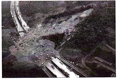
Landslides
The term 'landslide'1 includes all varieties of mass movements of hill slopes and can be defined as the downward and outward movement of slope forming materials composed of rocks, soils, artificial fills or combination of all these materials along surfaces of separation by falling, sliding and flowing, either slowly or quickly from one place to another. Although the landslides are primarily associated with mountainous terrains, these can also occur in areas where an activity such as surface excavations for highways, buildings and open pit mines takes place. They often take place in conjunction with earthquakes, floods and volcanoes. At times, prolonged rainfall causing landslide may block the flow of river for quite some time. The formation of river blocks can cause havoc to the settlements downstream on its bursting. Some of the common definitions are below in table.
Causes of Landslide
There are several causes of landslide. Some of the major causes are as follows:
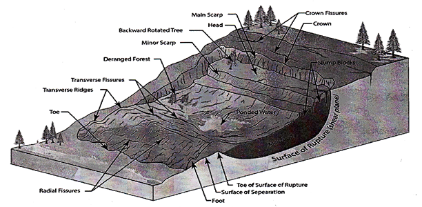
Type of Landslides
The common types of landslides are described below. These definitions are based mainly on the work of Varnes (Varnes, D.J., 1978).
Adverse Effects
The most common elements at risk are the settlements built on the steep slopes, built at the toe and those built at the mouth of the streams emerging from the mountain valley. All those buildings constructed without appropriate foundation for a given soil and in sloppy areas are also at risk. Roads, communication lines are vulnerable.

Distributional Pattern
Landslides constitute a major natural hazard in our country, which accounts for considerable loss of life and damage to communication routes, human settlements, agricultural fields and forest lands. The ndian subcontinent, with diverse physiographic, seismic, tectonic and climatological conditions is subjected to varying degree of landslide hazards; the Himalayas including Northeastern mountains ranges being the worst affected, followed by a section of Western Ghats and the Vindhyas. Removal of vegetation and toe erosion has also triggered slides. Torrential rainfall on the deforested slopes is the main factor in the Peninsular India namely in Western Ghat and Nilgiris. Human intervention by way of slope modification has added to this effect.
|
CASE STUDY One Uttarkhand (UP) on 11th and 17th August 1998 when nearly 380 people were killed when massive landslides washed away the entire village. This included 60 pilgrims going to Lake Mansarovar in Tibet. Consequently various land management measures have been initiated as mitigation measures of the worst tragedies took place at Malpa. |
Risk reduction measures
Hazard mapping locates areas prone to slope failures. This will help to avoid building settlements in such areas. These maps will also serve as a tool for mitigation planning. Land use practices such as:
Surface Drainage Control Works: The surface drainage control works are implemented to control the movement of landslides accompanied by infiltration of rain water and spring flows.
Engineered structures with strong foundations can withstand or take the ground movement forces. Underground installations (pipes, cables, etc.) should be made flexible to move in order to withstand forces caused by the landslide:
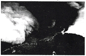
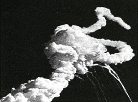
Volcanic Eruptions
A volcano is a rupture in the crust of a planetary-mass object, such as Earth, that allows hot lava, volcanic ash, and gases to escape from a magma chamber below the surface. Earth's volcanoes occur because its crust is broken into 17 major, rigid tectonic plates that float on a hotter, softer layer in its mantle. Therefore, on Earth, volcanoes are generally found where tectonic plates are diverging or converging. For example, a mid-oceanic ridge, such as the Mid-Atlantic Ridge, has volcanoes caused by divergent tectonic plates pulling apart; the Pacific Ring of Fire has volcanoes caused by convergent tectonic plates coming together. Volcanoes can also form where
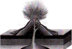
Causes of Volcano:
Volcanoes are caused by movement of tectonic plates deep within the earth's surface and along its ocean floors. Volcanoes are classified in two distinct categories: composite volcanoes and shield volcanoes. Composite volcanoes form from sticky and acidic lava; shield volcanoes, in contrast, form from basic lava. Over time, both types of volcanoes gradually increase in size. Inside their domes, gases and hot air accumulates and leads to increasing pressure. Eventually, volcanoes relieve themselves of these burdens through volcanic eruptions, which produce primary and secondary effects.
|
Plate Tectonics Divergent plate boundaries · At the mid-oceanic ridges, two tectonic plates diverge from one another as new oceanic crust is formed by me cooling and solidifying of hot molten rock. · Most divergent plate boundaries are at the bottom of the oceans; therefore, most volcanic activity is submarine, forming new seafloor. Convergent plate boundaries · In this case, the oceanic plate sub-ducts, or submerges under the continental plate forming a deep ocean trench, just offshore. · In a process called flux melting, water released from the sub-ducting plate lowers the melting temperature of the overlying mantle wedge, creating magma. · This magma tends to be very viscous due to its high silica content. · When it does reach the surface, a volcano is formed. E.g.: Volcanoes in the Pacific Ring of Fire. |
|
Hotspots "Hotspots" is the name given to volcanic areas believed to be fanned by mantle plumes, which are hypothesized to be columns of hot material rising from the core-mantle boundary in a fixed space that causes large-volume melting. Because tectonic plates move across them, each volcano becomes dormant and is eventually re-formed as the plate advances over the postulated plume. |
Types of Volcano
There are three main types of volcano - composite or strato, shield and dome.
Composite volcanoes, sometimes known as strato volcanoes, are steep sided cones formed from layers of ash and lava flows. The eruptions from these volcanoes may be a pyro-clastic flow rather than a flow of lava. A pyro-clastic flow is a superheated mixture of hot steam, ash, rock and dust. A pyro-clastic flow can travel down the side of a volcano at very high speeds with temperatures over 400 degrees Celsius. Composite volcanoes can rise over 8000 feet. When composite volcanoes erupt they are explosive and pose a threat to nearby life and property. Eruptions are explosive due to the thick, highly viscous lava that is produced by composite cone volcanoes. This viscous lava has a lot to do with why they are shaped the way they are. The thick lava cannot travel far down the slope of the volcano before it cools. Composite volcanoes are usually found at destructive plate margins. Examples of composite volcanoes include Mount Fuji (Japan), Mount St Helens (USA) and Mount Pinatubo (Philippines).
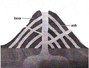
Acid lava is much thicker than lava which flows from shield volcanoes. Dome volcanoes have much steeper sides than shield volcanoes. This is because the lava is thick and sticky. It cannot flow very far before it cools and hardens. An example is Puy de Dome in the Auvergne region of France which last erupted over 1 million years ago.
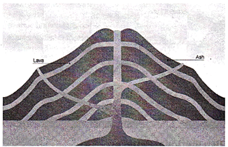
Shield volcanoes are low with gently sloping sides and are formed from layers of lava. Eruptions are typically non-explosive. Shield volcanoes produce fast flowing fluid lava that can flow for many miles. Eruptions tend to be frequent but relatively gentle. Although these eruptions destroy property, death or injury to humans rarely occurs. Shield volcanoes are usually found at constructive boundaries and sometimes at volcanic hotspots. Examples of shield volcanoes include Mourn Kilauea and Maunaloa on Hawaii.
Distribution Pattern
India
One active volcano in India is the Barren Island volcano, located in the Indian possession of the Andaman Islands. The volcano reaches a height of 1,161 feet above sea level. It is classified as a strato-volcano.
World
Volcanic belts are found above zones of unusually high temperature (700-1400 °C) where magma is created by partial melting of solid material in the Earth's crust and upper mantle. These areas usually form along tectonic plate boundaries at depths of 10-50 km.
Pacific Ring of Fire: The Ring of Fire is a major area in the basin of the Pacific Ocean where a large number of earthquake and volcanic eruptions occur.

Risk reduction measures
ANTHROPOGENIC HAXARD MANAGEMENT
Anthropogenic hazards are those hazards caused directly or indirectly by human action or inaction. They can be contrasted with natural hazards. Anthropogenic hazards may adversely affect humans, other organisms and biomes and eco-systems. The frequency and severity of hazards are key elements in some risk analysis methodologies. Hazards may also be described in relation to the impact that they have. Environmental hazards may be very different from human hazards. A hazard only exists if there is a pathway to exposure. As an example the center of the earth consists of molten material at very high temperatures which would be a severe hazard if contact was made with the core. However, there is no feasible way of making contact with the core; therefore the center of the earth currently poses no hazard.
Desertification
Desertification is a type of land degradation in which relatively dry area of land becomes increasingly arid, typically losing its bodies of water as well as vegetation and wildlife. It is caused by a variety of factors, such as through climate change and through the overexploitation of soil through human activity. When deserts appear automatically over the natural course of a planet's life cycle, then it can be called a natural phenomenon; however, when deserts emerge due to the rampant and unchecked depletion of nutrients in soil that are essential for it to remain arable, then a virtual "soil death" can be spoken of which traces its cause back to human overexploitation. Desertification is a significant global ecological and environmental problem.
Causes of Desertification
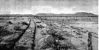
Image showing deserted land
Vegetation Patterning
As the desertification takes place, the landscape may progress through different stages and continuously transform in appearance. On gradually sloped terrain, desertification can create increasingly larger empty spaces over a large strip of land, a phenomenon known as "Brousse tigree". A mathematical model of this phenomenon proposed by C. Klausmeier attributes this patterning to dynamics in plant water interaction. One outcome of this observation suggests an optimal planting strategy for agriculture in arid environments.
Distributional Patterns: India
Risk Reduction Measures
Farmer-managed natural regeneration (FMNR) is another technique that has produced successful results for desert reclamation.
Managed grazing: Restoring grasslands store \[C{{O}_{2}}\] from the air into plant material. Grazing livestock, usually not left to wander, would eat the grass and would minimize any grass growth while grass left alone would eventually grow to cover its own growing buds, preventing them from photosynthesizing and killing the plant.
Fires
Mitigating Process
Fire mitigation removes fuels around the house that can create increased heat and exposure to your home in the event of a wild land fire. The impact of these fires can be minimized or mitigated by creating a defensible space and taking other actions to reduce the intensity of the fire and help fire crews fight fires that may threaten your home. Due to fire trees and shrubs continue to grow, trees drop their leaves and needles, plants die and new plants sprout up, defensible space requires annual maintenance. The following are the mitigation activities:
Industrial Hazard
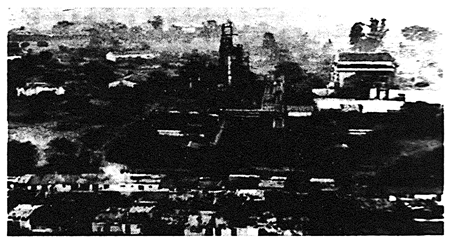
Industrial accidents resulting in releases of hazardous materials usually occur in a commercial contest, such as mining accidents. They often have an environmental impact but also can be hazardous for people living in proximity. The Bhopal disaster saw the release of Dioxins into the neighboring environment seriously affecting large numbers of people.

Bhopal Disaster
The Bhopal disaster, also referred to as the Bhopal gas tragedy, was a gas leak incident in India, considered the world's worst industrial disaster.
It occurred on the night of 2-3 December 1984 at the Union Carbide India Limited (UCIL) pesticide plant in Bhopal. Madhya Pradesh. Over 500,000 people were exposed 10 methyl isocyanate (MIC) gas and other chemicals. The highly toxic substance made its way into and around the shanty highly located near the plant.
Waste Disposal
In developed economies, many hazardous materials are put in the domestic and commercial waste stream. In part this is because modem technological living uses many hazardous materials which, when they are in use, are safely encapsulated packaged to avoid any exposure route. In the waste stream, the packaging or encapsulation breaks or degrades and there is an exposure route to hazardous materials for people working in the waste disposal industry, those living around sites used for waste disposal and the general environment surrounding such sites.
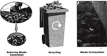
Waste Disposal/ Mitigation Process
Landfill: A landfill site (also known as a tip, dump, rubbish dump, garbage dump or dumping ground) is a site for the disposal of waste materials by burial and the oldest form of waste treatment.
Incineration: Incineration is a disposal method in which solid organic wastes are subjected to combustion so as to convert them into residue and gaseous products. This method is useful for disposal of residue of both solid waste management and solid residue from waste water management. This process reduces the volumes of solid waste to 20 to 30 percent of the original volume. Incineration and other high temperature waste treatment systems are sometimes described as "thermal treatment". Incinerators convert waste materials into heat, gas, steam, and ash.
Recycling and Re-Use: Recycling is a resource recovery practice that refers to the collection and reuse of waste materials such as empty beverage containers. The materials from which the items are made can be reprocessed into new products. Material for recycling may be collected separately from general waste using dedicated bins and collection vehicles, a procedure called kerbside collection.
Transportation
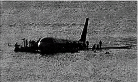
Aviation
An aviation incident is an occurrence other than an accident, associated with the operation of an aircraft, which affects or could affect the safety of operations, passengers, or pilots. The category of the vehicle can range from a helicopter, an airliner, or a space shuttle.
Rail: The special hazards of traveling by rail include the possibility of a train crash which can result in substantial loss of life. Incidents involving freight traffic generally pose a greater hazardous risk to the environment.
Road
Traffic collisions are the leading cause of death, and road based pollution creates a substantial health hazard, especially in major conurbations, i.e. urban areas.
Space
Space travel presents significant hazards, mostly to the direct participants (astronauts or cosmonauts and ground support personnel), but also carry the potential of disaster to the public at large. Accidents related to space travel have killed 22 astronauts and cosmonauts, and a larger number of people on the ground.
Sea travel
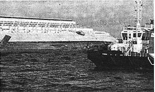
Ships can sink, capsize or crash in disasters. Perhaps the most infamous sinking was that of the Titanic which hit an iceberg and sank, resulting in one of the worst maritime disasters in history.
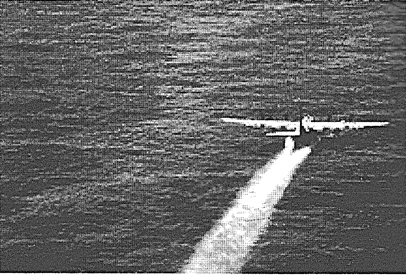
Oil Spills
An oil spill is the release of a liquid petroleum hydrocarbon into the environment, especially marine areas, due to human activity, and is a form of pollution. The term is usually applied to marine oil spills, where oil is released into the ocean or coastal waters, but spills may also occur on land.
Cleanup and Recovery
Spills may take weeks, months or even years to clean up. Cleanup and recovery from an oil spill is difficult and depends upon many factors, including the type of oil spilled, the temperature of the water (affecting evaporation and biodegradation), and the types of shorelines and beaches involved.
Methods for cleaning up
Equipment used
Disaster Risk Reduction
Disaster Risk Reduction (DRR) aims to reduce the damage caused by natural hazards like earthquakes, floods, droughts and cyclones, through an ethic of prevention. Disasters often follow natural hazards. A disaster's severity depends on how much impact a hazard has on society and the environment. The scale of the impact in turn depends on the choices we make for our lives and for our environment. These choices relate to how we grow our food, where and how we build our homes, what kind of government we have, how our financial system works and even what we teach in schools. Each decision and action makes us more vulnerable to disasters - or more resilient to them.
The Seven Global Targets
(a) Substantially reduce global disaster mortality by 2030, aiming to lower average per 100,000 global mortality rates in the decade 2020-2030 compared to the period 2005-2015.
(b) Substantially reduce the number of affected people globally by 2030, aiming to lower average global figure per 100,000 in the decade 2020 -2030 compared to the period 2005-2015.
(c) Reduce direct disaster economic loss in relation to global gross domestic product (GDP) by 2030.
(d) Substantially reduce disaster damage to critical infrastructure and disruption of basic services, among them health and educational facilities, including through developing their Resilience by 2030.
(e) Substantially increase the number of countries with national and local disaster risk reduction strategies by 2020.
(f) Substantially enhance international cooperation to developing countries through adequate and sustainable support to complement their national actions for implementation of this Framework by 2030.
Substantially increase the availability of and access to multi-hazard early warning systems and disaster risk information and assessments to the people by 2030.
The Four Priorities for Action
Priority 1. Understanding disaster risk
Disaster risk management should be based on an understanding of disaster risk in all its dimensions of vulnerability, capacity, exposure of persons and assets, hazard characteristics and the environment. Such knowledge can be used for risk assessment, prevention, mitigation, preparedness and response.
Priority 2. Strengthening disaster risk governance to manage disaster risk
Disaster risk governance at the regional; national and global levels is very important for prevention, mitigation, preparedness, response, recovery, and rehabilitation. It fosters collaboration and partnership.
Priority 3. Investing in disaster risk reduction for resilience
Public and private investment in disaster risk prevention and reduction through structural and non-structural measures are essential to enhance the economic, social, health and cultural resilience of persons, communities, countries and their assets, as well as the environment.
Priority 4. Enhancing disaster preparedness for effective response and to "Build Back better" in recovery, rehabilitation and reconstruction
The growth of disaster risk means there is a need to strengthen disaster preparedness for response, take action in anticipation of events, and ensure capacities are in place for effective response and recovery at all levels. The recovery, rehabilitation and reconstruction phase is a critical opportunity to build back better, including through integrating disaster risk reduction into development measures.


You need to login to perform this action.
You will be redirected in
3 sec

