Notes - Where in the World are We? Latitudes and Logitudes
Category : 6th Class
Where in the World are We? Latitudes and Longitudes
Summary
1. Lines of latitude are the horizontal lines that go around the globe. The equator runs through the middle and is the most important line of latitude. It makes an angle of \[0{}^\circ \] with the plane crossing through the middle of the earth. The equator is the main line of reference.
2. Lines of longitude are the vertical lines on the globe. These lines join the North and South Poles. The Prime Meridian or \[0{}^\circ \] longitude is the main line of reference on the globe.
3. While locating places on the globe or on maps, the latitude is always read first and then the longitude.
4. Latitudes and longitudes are measured in degrees\[\,({}^\circ )\]. Each degree is divided into 60 smaller parts called minutes (?).
5. Lines of latitude are parallel to each other. They decrease in length towards the poles. Longitudes, on the other hand, are of the same length. The distance between the two longitudes reduces when they move towards the poles. At poles, they join one another.
6. The important latitudes help us divide the earth into different Heat Zones or Climate Zones as different places on the earth receive different amounts of sunlight as per their latitudinal location.
7. There is a direct relationship between the longitude of a place and the time of the place. There is a difference of time between the two consecutive longitudes, i.e. four (4) minutes. All places on a given meridian or longitude have the same local time.
8. The local time of a place is bound to differ as per their territorial expanse over different longitudes. To avoid confusion of time, countries have a Standard (Central) Meridian. A country having much wider expanse can have more than one Standard Time or Time zones like U.S.A.
9. The International Date Line is the \[180{}^\circ \] meridian. The day and date change on this line. This line is curved at several points to avoid confusion of days and dates in the same territory.
Piyush was standing on the Marina Beach, Chennai. Before him is a vast endless sea. Looking out at the horizon he began to wonder which lands lie beyond these waters? He went back to his uncle?s home and asked, "the world is so big, how can one locate a place on the Earth. How can I find the location of the countries where my internet friends live? His uncle replied, "Well Piyush! Hundreds of years ago, this was the big question in everybody?s mind. People used to follow the stars to find their way around the world. Today we have better options for them?.
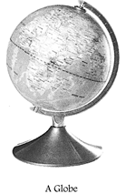
The earth we live on is very big and vast. Locating a place on its surface is not an easy task. For the convenience of study, geographers have developed a small model of the earth which we call a 'globe'. A globe is a true, spherical representation of the earth. It comes from the Latin word globus meaning 'round mass or 'sphere'. Land masses (continents) and water bodies (seas and oceans) are shown on it in colours of green and blue respectively.
The earth rotates on its tilted axis which causes the occurrence of day and night. Like the earth, a globe is also made to rotate on its axis. The axis of the earth is an imaginary line (it may be real in a globe) that passes exactly through its centre and meets at two opposite points known as the poles. Both the poles, i.e. the North Pole and the South Pole are used as reference points for locating a place. Locating a place on the earth's surface have been made easier by drawing imaginary lines (latitudes and longitudes) on the globe. Here, we will study about them in detail.
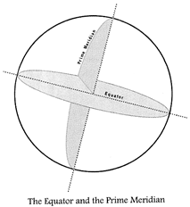
THE EQUATOR AND THE PRIME MERIDIAN
If we look at the globe carefully, we see a line that runs exactly in the middle of it. This divides the globe (earth) into two equal halves. This line is called the equator. (The equator is considered to be at 0° as it passes through the centre of the earth and makes no angle with it.) The area falling north of the equator is the Northern Hemisphere and the area falling south of the equator is the Southern Hemisphere.
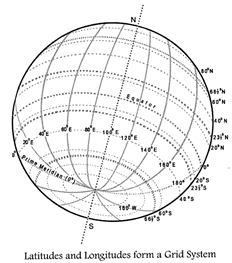
The equator is used as a reference line on the surface of a globe (earth) drawn horizontally. A number of other horizontal lines are drawn parallel to the equator. These lines are called latitudes or parallels of latitude. Besides, there are vertical lines on the globe that meet at the poles. These lines are called and Longitudes at the poles. These longitudes or meridians. Among them, there is a Prime Meridian that is considered to be at 0°. The area falling east of it is known as the Eastern Hemisphere and that to the west is known as the Western Hemisphere. The Prime Meridian is also used as a reference line. All these latitudes and longitudes form a grid system that helps us find the location of a place or the geographical features on the globe (earth). It is called as 'graticule'.
It is important to note here that all the latitudes and longitudes are imaginary lines; they are not real ones. These lines are drawn on the globe to help us to find the location of a place. We should also note that the earth is not a perfect sphere, it is flat at both (north and south) ends and bulging in the middle. Therefore, the polar diameter of the earth is shorter than that of the equatorial diameter by about 43 kilometres.
PARALLELS OF LATITUDE
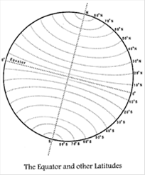
The best known line of latitude is the equator at \[0{}^\circ \]. The other lines of latitude are measured from the equator in both north and south directions. Lines of latitude are drawn parallel to each other at an interval of \[1{}^\circ \]. All these lines of latitude form a series of hoops around the globe. The North Pole, therefore, is \[90{}^\circ \] north and the south I Pole is \[90{}^\circ \] south of the equator. Thus, a total of 181 lines of latitude (including the equator) are drawn on the globe (earth). Since, the latitude of a place is the angular distance, it is expressed in degrees followed by the letter N if the place is in the Northern Hemisphere and S if the place is in the Southern Hemisphere.
Lines of latitude are referred to as parallels as they encircle the earth parallel to one another.
Some of these parallels form boundaries between two countries or two states.
Activity
Look at the globe and tick (3) the correct option for each of the following questions.
1. The latitude that forms a boundary between Canada and USA is:
(a) \[50{}^\circ \] N parallel (b) \[49{}^\circ \] N parallel
2. The parallel of latitude that forms the boundary between the states of North Carolina and Georgia in the United States of America is:
(a) \[35{}^\circ \]B N parallel (b) \[5{}^\circ \] N parallel
3. The parallel of latitude that forms the boundary of North Korea from that of South Korea is:
(a) \[8{}^\circ \] N parallel (b) \[38{}^\circ \] N parallel
Main Characteristics of the Lines of Latitudes
? All lines of latitude are parallel to each other and therefore, they do not meet one- another at any point.
? Lines of latitude are hoops or circles which keep decreasing in size towards the poles. The North and South Poles are only points and not circles. The equator is the longest line of latitude.
? Latitudes are drawn at intervals of \[1{}^\circ \].
? The distance between two consecutive latitudes is about 111 kilometres.
? There are 181 lines of latitudes: 90 each to the north and south of the equator and the equator itself.
Important Lines of Latitude
There are five major lines of latitude, which are used as reference lines as they help to locate a place on the globe. They are the: (i) Equator\[0{}^\circ \], (ii) Tropic of Cancer\[23V2{}^\circ N\], (iii) Tropic of Capricorn\[23V2{}^\circ S\], (iv) Arctic Circle, and (v) the Antarctic Circle.
The equator is marked as\[0{}^\circ \]. It makes a \[0{}^\circ \] angle with the horizontal plane at the centre of the earth. It is an important latitude as it divides the earth into the Northern and Southern Hemispheres. The North and South Poles are important reference points. Different places on the earth receive different amounts of sunlight or insolation according to their locations at different latitudes.
All these important latitudes help us divide the earth's surface into three major temperature or heat zones. Different amounts of insolation on these heat zones cause different types of climate in these regions.
CLIMATE ZONES OF THE EARTH
The three distinct climate or heat zones on the earth are the (i) Torrid Zone, (ii) Temperate Zone, and the (iii) Frigid Zone.
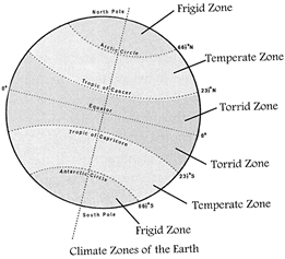
The Torrid Zone
The Torrid Zone lies roughly between the Tropic of Cancer and the Tropic of Capricorn. Torrid means 'hot'. This region receives maximum heat as it lies at both sides of the equator. The Sun's apparent movement is within the tropics. The Sun is overhead practically on the equator throughout the year. That is why, this zone is known as the Torrid Zone. Southern India, Thailand, Singapore and other countries of Southern Asia, Indonesia, Northern Africa, Central and Northern South America fall in this zone.
The Temperate Zone
The Temperate Zone lies between the Tropic of Cancer and the Arctic Circle in the Northern Hemisphere, and between the Tropic of Capricorn and the Antarctic Circle in the Southern Hemisphere. The Temperate Zones in both the Northern and Southern Hemispheres do not get the direct rays of the Sun. So, the Temperate Zone is a region of moderate climate; neither too hot nor too cold. It has four distinct seasons, i.e. Spring, Summer, Autumn and Winter. Europe, Northern Asia, North America, Great Britain and Japan fall in the Northern Temperate Zone while New Zealand, southern part of South America, Australia and also South Africa lie in the Southern Temperate Zone.
The Frigid Zone
The Frigid Zone lies between the Arctic Circle and the North Pole in the Northern Hemisphere and between the Antarctic Circle and the South Pole in the Southern Hemisphere. These two zones are also known as Polar Regions. These areas always get the slanting rays of the Sun, so they are the coldest areas on the earth. The North Frigid Zone includes Northern Canada, Alaska, Greenland, Northern Russia and the Scandinavian countries such as Norway, Sweden and Finland. The Southern Frigid Zone includes the countries of Chile, Argentina, New Zealand and of course, Antarctica.
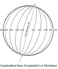
LONGITUDES OR MERIDIANS
Lines of longitude are the vertical lines on the globe. They are drawn from the North Pole to the South Pole. You may liken the appearance of the earth with these lines to that of a peeled orange.
If we cut a peeled orange into half vertically, the cut out face of the orange will look like a whole circle. As we already know, there are 360 degrees in a circle. Thus, we can draw 360 lines of longitude if we keep these longitudes at an interval of\[1{}^\circ \]. The starting line of the longitude is said to be at\[0{}^\circ \]. This line of longitude is called the Prime Meridian. Meridian is a Latin word which means mid-day. The Prime Meridian runs through the Royal Observatory in Greenwich, England. Other meridians (longitudes) are either east of Prime Meridian or, on the west of it. Meridians (longitudes) lying east of the Prime Meridian, written as ...°E, and those which lie west of the Prime Meridian are written as ...\[{}^\circ W\].
Directly opposite to the Prime Meridian lies the \[180{}^\circ \] longitude which is both east and west of the Prime Meridian. From \[0{}^\circ \] to \[180{}^\circ \] east is the Eastern Hemisphere while from \[0{}^\circ \] to \[180{}^\circ \] west is the Western Hemisphere.
Main Features of the Lines of Longitude
? Lines of longitude are the vertical lines that join the North and South Poles.
? Lines of longitude are also called meridians.
? Meridians are drawn at an interval of\[1{}^\circ \]. The distance between the two consecutive meridians (longitudes) keeps on decreasing towards the poles. At the poles, they join each other. However, on the equator, this distance is the widest. The distance between the two consecutive longitudes at the equator is about 111 kilometres.
? The Prime Meridian is considered a reference line on the globe (earth) as it is marked at \[0{}^\circ \] longitude.
? There are 360 lines of longitude; 180 each in the east and west of the globe.
? All lines of longitude are semicircles. Also, they are of the same length as they meet at the poles.
? The lines of longitude help us in determining the time.
? The time at Greenwich Meridian (Prime Meridian) at \[0{}^\circ \] is considered the International Standard Time (1ST) worldwide. The difference between the two consecutive longitudes is \[1{}^\circ \] (4 minutes). Therefore, at a longitudinal difference of\[15{}^\circ \], there will be a time difference of 1 hour. The local time of a place is determined by taking Greenwich Meridian Time (GMT) as a reference. The local time is calculated by measuring the longitudinal difference of that place with the Prime Meridian in degrees. All places along the same longitude (meridian) have the same time.
? The Prime Meridian divides the earth into the Eastern and Western Hemispheres.
LOCATING PLACES WITH THE HELP OF LATITUDES AND LONGITUDES
LONGITUDES AND TIME
The Global Time System has oriented from the Sun and its movement. The relationship between the Earth and the Sun is considered as the best time-keeper in the world.
We notice every day that the Sun rises in the east and moves across the sky westward. The apparent movement of the Sun across the sky is due to the rotation of the earth on its axis from west to east. One rotation of the earth takes about 24 hours and makes an angle of\[360{}^\circ \].
For the calculation of time, we take Prime Meridian or Greenwich Meridian as a reference. As the earth rotates from west to east, places lying east of Greenwich Meridian, i.e. \[0{}^\circ \]Meridian will be ahead of Greenwich Time and those which are west of it, will be behind it.
Activity
You have to explore some of the world's natural wonders. Before you go there, you have to find out where are these natural wonders located. Use the internet and the globe. Find out their locations. Write the latitude and longitude for each of these places in the table below:
|
Natural Wonders |
Country |
Location |
|
|
|
|
Latitude |
Longitude |
|
Mount Kilimanjaro |
|
|
|
|
Angel Falls |
|
|
|
|
Grand Canyon |
|
|
|
|
Iguazu Island |
|
|
|
|
Krakatau Island |
|
|
|
|
Mount Everest |
|
|
|
|
Great Barrier Reef |
|
|
|
Let us calculate the rate of difference. The earth rotates 360° in about 24 hours. It means that the earth rotates by 15° in an hour or we can say that the earth rotates by 1° in four minutes. Therefore, if it is 12 noon at Greenwich, the time at 15° E of Greenwich will be 15 x 4 = 60 minutes or 1 hour ahead of Greenwich, so the time at the 15° E will be 1 pm. But at 15° W of Greenwich the time will be behind the Greenwich time: that also by one hour. So, it will be 11.00 am at 15°W. However, on 180° longitude, it will be 12 midnight when it is 12 noon at Greenwich. It is important to note that all places on a given meridian of longitude will have the same local time.
Activity
You can locate places by another method also. Draw equidistant vertical and horizontal lines in your notebook as given below. Label the vertical lines with letters of the alphabet and the horizontal lines with numbers. Now draw random circles on points where both two lines (horizontal and vertical) meet and name these circles as a, b, c and d. The vertical lines are longitudes and the horizontal ones are latitudes. Imagine the latitudes are in the Northern Hemisphere and the longitudes are in the Eastern Hemisphere.
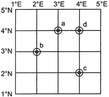
Now, we can find out the location of each of the circles a, b, c, and d. One example given.
|
Places |
Location |
|
|
Latitude |
Longitude |
|
|
Circle (a) |
\[{{4}^{{}^\circ }}N\] |
\[{{3}^{{}^\circ }}E\] |
|
Circle (b) |
|
|
|
Circle (c) |
|
|
|
Circle (d) |
|
|
Time Zones and Variation of Time
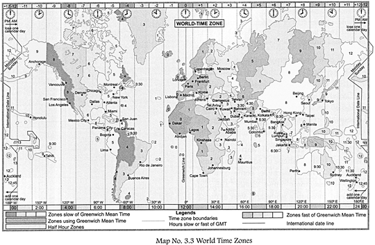
The earth takes about 24 hours to complete one rotation; it is, therefore, divided into 24 different Time Zones. Each of the earth's Time Zone has a width of 15° longitudes. This corresponds with each hour of the day as well as with the earth's rotation by 15 degrees. All places within a Time Zone follow the same time. Countries with a large east to west extent have more than one Time Zone. The United States of America has five Time Zones, Canada has 6 while Russia has 11 Time Zones.
Local Time and Standard Time
We have seen how a difference of \[1{}^\circ \] meridian leads to a change in the local time. We also know that the area of a country could be spread over a number of meridians. In this condition, a country could have a number of local times. There would be great confusion, if all places on different meridians within the same country follow their own local time. For example, it will be difficult to prepare a time table for trains which cross several longitudes. In India, for example there will be difference of about 1 hour and 45 minutes in the local time of Dwarka in Gujrat and Dibrugarh in Assam. Thus, it was necessary to adopt the same local time for the country with a smaller west to east extent. For this purpose, the central meridian of that country is taken as a Standard Meridian. The local time at that Standard Meridian is used as the Standard Time for the whole of the country.
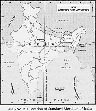
Geography Reveals
The Standard Meridian of India for calculating the Standard Time in India has been fixed at \[82{}^{1}/{}_{2}{}^\circ \] E, which passes through Allahabad and Chennai.
The time difference between the Greenwich Mean Time (GMT) and the Indian Standard Time (1ST) is 5 hours 30 minutes. As India is in the Eastern Hemisphere, our Indian Standard Time is 5:30hrs ahead of GMT. That means, if it is 12 noon at Greenwich, England, it will be 5:30 pm in India.
If we look at the Time Zone Map in an atlas, we will find that the shape of some Time Zones are irregular. This is because, some countries have to adjust their Time Zones although they extend through a wide and vast expanse.
Every country wants that all the constituting states or provinces should have the same time frame, so that the people living there can save themselves from any confusion of time.
THE LONGITUDES AND INTERNATIONAL DATE LINE
On the globe, the opposite side of the Prime Meridian is the International Date Line. The International Date Line is located on the longitude of\[180{}^\circ \].
The International Date Line is the line where one calendar day ends and another one starts. The date on the east of this line is one day ahead of that on the west side. For example, if it is Monday, the 27th of July on the east side of this International Date Line, on the west of this line it will be 26th July, Sunday. We can learn it in this way also. Suppose we travel from India, which is east of the Prime Meridian to the North America which is on the west, we gain a day as we cross the International Date Line. On our return journey, we lose a day.
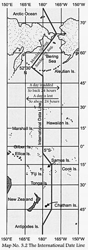
The International Date Line also does not follow the \[180{}^\circ \] line of longitude exactly. It has been curved at many places to avoid any difference of time, day and date. One can notice easily that some landmasses and islands are located around the International Date Line. If this meridian is a straight line, the landmasses and islands spread on both sides of this meridian would have two different dates and days although they are parts of the same territory.
 .
.


You need to login to perform this action.
You will be redirected in
3 sec

