Notes - Our Country India-Location and Physical Features
Category : 6th Class
Our Country India-Location and Physical Features
Summary
1. India is located in the Northern and the Eastern Hemisphere.
2. India shares common boundaries with seven countries; Afghanistan, Pakistan, China, Nepal, Bhutan, Bangladesh and Myanmar.
3. India has 29 states and 7 union territories, including the National Capital Territory of Delhi.
4. For administrative purposes the states are further divided into districts and tehsils.
5. To fix the standard time of India, the \[82.5{}^\circ E\] longitude has been taken as the standard meridian.
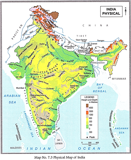
6. India is a part of a subcontinent and can be divided into six distinct physical divisions - The Northern Mountain Wall, the Northern Plains, the Great Indian Desert, the Indian Plateau, the Coastal Plains and Islands.
7. The Northern Mountain Wall mostly consists of the Himalayas with an arc-shaped chain of three parallel ranges - the Himadri, Himachal and Shiwalik.
8. Towards the south of the Himalayas are the Northern Plains and to the west is the Great Indian Desert which extends into Pakistan.
9. The plateaus of peninsular India are flanked by the mountain ranges of the Western and Eastern Ghats, and surrounded by the Coastal Plains.
10. The Lakshadweep in the Arabian Sea and the Andaman and Nicobar Islands in the Bay of Bengal are also parts of India.
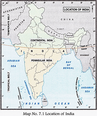
India is a country of vast geographical expanse in South Asia. It is set apart from the rest of Asia by the lofty wall of the Himalayas in its north. The southern part is surrounded by water and this makes it a peninsula. Three large bodies of water that surround the Indian peninsula are the Arabian Sea in the West, the Bay of Bengal in the East and the Indian Ocean in the South, making it distinctly recognisable on the globe. India is the seventh largest country in the world after Russia, Canada, China, USA, Brazil and Australia. It is the second most populous country in the world 1.28 billion in 2015 after China with a population of 1.37 billon in 2015.
INDIA?LOCATION, EXTENT AND NEIGHBOURS
India is located in the Northern and Eastern Hemisphere. The Tropic of Cancer (23.5°N latitude) passes almost midway through the country. Its latitudinal extent is 8°4^N and 37°6'N and the longitudinal extent is 68°7'E and 97°25'E.
With a total land area of 3.3 million sq km, India accounts for about 2.4 per cent of the total land area of the world. It has a land frontier of 15,200 km and a coastline of 7,516.5 km of which, 5,423 km belongs to peninsular India, and 2,094 km to the islands off shore.
The Andaman and Nicobar Islands in the Bay of Bengal and Lakshadweep in the Arabian Sea are parts of India. The north-south extent from Kashmir to Kanyakumari is about 3,200 km, and the east-west extent from Arunachal Pradesh to Kutch is about 2,900 km. Cape Comorin in Kanyakumari is the southernmost tip of the mainland, while Indira Point in the Andaman and Nicobar islands is the farthest point in the south.
You have learnt earlier that the time difference between two consecutive longitudes is four minutes. Due to India's great longitudinal extent there would be a wide difference in its local time from west to east. To avoid any confusion with respect to time at different places in India, the centrally located longitude 82.5° E has been selected as the standard meridian for the whole country. Nepal and Sri Lanka also use this meridian for their standard time. The local time of the standard meridian is called the Indian Standard Time (1ST).
Geography Reveals
The Sun rises two hours earlier in Arunachal Pradesh than in Gujarat.
India has common land boundaries with seven countries?Afghanistan and Pakistan to the North-west, China, Nepal and Bhutan to the north, and Bangladesh and Myanmar to the east. To the south, across the sea lies the island of Sri Lanka separated by the Palk Strait and the Maldives.
The landmass comprising Afghanistan, India, Pakistan, Bangladesh, Nepal, Bhutan, Sri Lanka, and the Maldives is isolated in a remarkable way from the rest of Asia forming a sub-division of the continent. This landmass is known as the Indian subcontinent.
Q. Can you think of any other important factor which lends unity to the subcontinent?
POLITICAL AND ADMINISTRATIVE DIVISIONS OF INDIA
Politically India is divided into 29 states and 7 union territories which also include the National Capital Territory of Delhi.
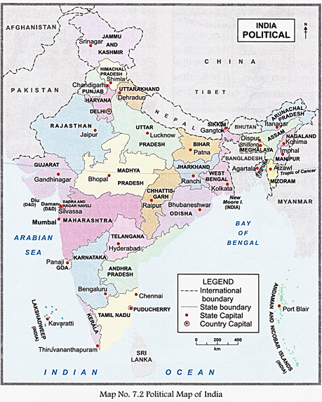
For administration convenience, the states are further subdivided into districts and tehsils.
? Rajasthan is the largest state while Goa is the smallest.
? Uttar Pradesh has the largest number of districts and the highest population.
PHYSICAL DIVISION OF INDIA
India presents a diversity of landforms with hills, rivers, plateaus, plains, beaches, deltas and deserts. The great landmass thus is divided into five major physical divisions:
(i) The Great Northern Mountain Wall bordering the north,
(ii) The Great Northern Plains stretching across the central and eastern part,
(iii) The Great Indian Desert lying in the west,
(iv) The Great Peninsular Plateau spreading across southern India,
(v) The Coastal Plains bordering it and the chain of islands off the coasts.
THE GREAT NORTHERN MOUNTAIN
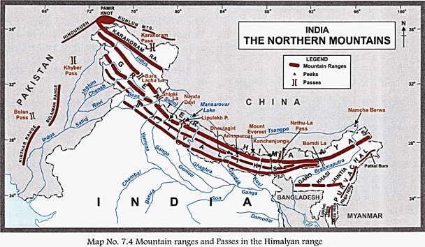
The Hindu Kush, the Karakoram and the Himalayas extend from the Pamir Knot of Central Asia and form a continuous stretch of mountains from Kashmir in the west to Assam in the east, thus shielding the north like a wall.
The Karakoram Mountains enter India in Kashmir and extend towards Tibet in the east where they are known as the Kailash range. Mount Godwin-Austin or K2 lies in this mountain range in the Gilgit-Baltistan part of disputed Kashmir. It is the second highest peak in the world and is 8,611 metres high. Baltoro and Siachen are important glaciers found in this range. Towards the south of the Karakoram range are the Ladakh and Zaskar ranges. The River Indus flows between these ranges.
The west to Arunachal in the east covering a distance of 2,400 km in a gigantic arc. They vary in width from 240 to 320 km.
The Himalayas can be divided into three zones? The Himadri or the Greater Himalayas with the highest and oldest peaks, the Himachal or the Middle Himalayas where most hill stations are located and the Shiwalik or the outer Himalayas, which are the southernmost ranges.
Geography Reveals
The Pamir Mountains in Central Asia form a junction or knot of a few mountain ranges that include the Himalayas, the Karakoram, the Kunlun and the Hindu Kush. They are among the world?s highest mountains.
The Himadri also called the Greater Himalayas has an average height of 6,000 m It comprises the zone of high snow-capped peaks.
It has the loftiest peak of the world?Mount Everest with a height of 8,850 m, located in Nepal.
Some of the other important peaks are Kanchenjunga in Sikkim (8,598 m), Dhaulagiri (8,177 m), Nanga Parbat (8,126 m) and Nanda Devi (7,818 m).
The Gangotri and Yamnotri glaciers are found here and the Rivers Ganga and Yamuna originate from these glaciers.
The Himachal also known as the Middle Himalayas lies to the south of the Himadri.
It is 64 to 80 km wide and has an average elevation of 4,500 m.
It is covered with evergreen and oak forests, and coniferous forests of chir, deodar, pine, etc.
Most of the hill stations?Manali, Kulu, Dalhousie, Mussoorie, Nainital and Darjeeling are situated here.
The Shiwalik also called the Outer Himalayas has an average height of 1,200 m. They extend along the foot of the Himachal from the Potwar plateau and the Bannu plains on the west to the Brahmaputra Valley on the east.
There are broad valleys between the Himachal and Shiwalik ranges known as 'duns'. Dehradun and Patli dun are two such duns.
The eastern part of Shiwalik is known as Poorvanchal. It consists of the Khasi, Jaintia, Mizo and Naga hills, and the Patkai Bum, spanning across the states of Assam, Meghalaya, Nagaland, Mizoram, Manipur and the Union Territory of Arunachal Pradesh.
Along the foothills of the Shiwaliks, the plains have a deposition of gravel, pebbles and sand brought down by the rivers. It is known as 'the Bhabar?.
To the south of bhabar is the Terai plain, a belt of marshy grasslands where water flows down making it a marshy land. The Terai is an agriculturally productive and heavily forested area.
The Influence of the Mountain
The mountain wall has a great influence on the land and people.
? Since historic times, it has restricted infiltration1 and foreign attacks.
? It has passes2 like the Khyber Pass between Afghanistan and Pakistan, the Bolan Pass in Pakistan, Which help in communication and trade. The Karakoram Zojila Pass in Jammu and Kashmir, the Shipki La in Himachal Pradesh and Bomdila Pass in Arunachal Pradesh.
? The Himalayas protect the Northern Plains from the bitterly cold winds of Central Asia during winter.
? The rain-bearing monsoon winds cause rainfall on the northern plains due to these mountains.
? Its massive glaciers and snow fields are sources of many perennial rivers whose waters provide irrigation and hydro- electric power.
? The silt brought down by these rivers has made the Northern Plain very fertile.
? Forested slopes are valuable resources of timber and other useful products.
? They shelter a wide variety of wildlife.
? Beautiful scenery make it important for tourism.
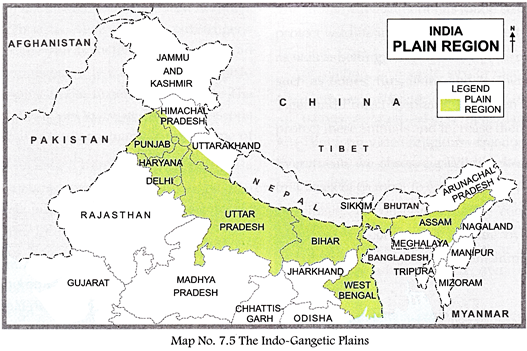
THE NORTHERN PLAINS
The Northern Plains, also known as the Indo- Gangetic Plains, are extensive fertile lands covering most of northern and eastern India.
The land is made fertile by alluvial soil deposited by the rivers.
The Northern plains span the states of Punjab, Haryana, Uttar Pradesh, Madhya Pradesh, Bihar, Jharkhand and West Bengal.
The three main river basins which form these plains are drained by the rivers?Indus, Ganga and the Brahmaputra.
The Indus river, 2,700 km long, originates in the south-western part of Tibetan Plateau in the
Kailash ranges and drains into the Arabian Sea. Many of its tributaries3 rise from the Zaskar and Ladakh glaciers of the Karakoram range. It flows westwards through Kashmir and enters Punjab. Punjab (the land of five rivers) is irrigated by five of its main tributaries?the Jhelum, Chenab, Ravi, Satluj and Beas.
The River Ganga rises at the foot of the Gangotri glacier, at Gaumukhand and enters the Plains at Haridwar. A large number of tributaries join the river and drain the northern part of India and Bangladesh. Tributary Yamuna joins the Ganga at Sangam in Allahabad. The other tributaries are the Gomti, Ghaghra (the largest), Gandak, Kosi, Chambal, Betwa, Son and Damodar.
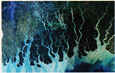
The Brahmaputra river, originates in south- western Tibet as the Yarlung Tsangpo, and flows across Southern Tibet cutting deep gorges4 in the Himalayas. It enters Arunachal Pradesh where it is known as Dihang. It then turns south-west through the Assam Valley as the Brahmaputra and flows south into Bangladesh as the Jamuna. There, completing a journey of about 2,900 km, it merges with the Ganges to form the world largest delta5?the Sunderbans. Its important tributaries are Sabansari, Barali, Mansa, Buri, Dehing and Dhauser.
Geography Reveals
The Sunderban is a part of the work?s largest detla formed by the rivers Ganges, Brahmaputra Meghna. It has a vast tract of forest and swamp where you can find jungle cat, axis deer, wild boar, rhesus monkey, white tiger, the largest estuarine crocodile variety of birds.
THE THAR DESERT
Spreading over an area of more than 200,000 sq km, the Thar Desert is a large, arid region in north-western India forming a natural boundary between India and Pakistan. It lies mostly in the state of Rajasthan and stretches into southern Haryana, Punjab and northern Gujarat.
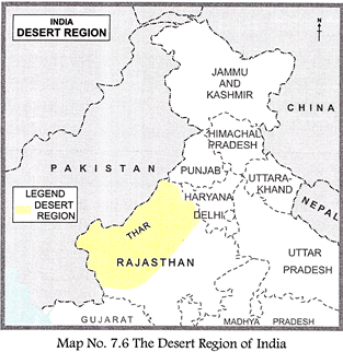
On the east it is bordered by the Aravali range and on the south by the salt marsh known as the Rann of Kachh.
The Indus River borders it on the west. Luni is the only river, and Lake Sambhar is a salt water lake here. The man-made Indira Gandhi Canal irrigates the desert carrying water from the River Satluj.
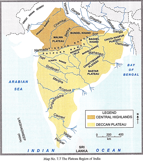
THE CENTRAL HIGHLANDS AND SOUTHERN PLATEAUS
The highlands comprise mainly of three plateaus?the Malwa Plateau in the west, the Chota Nagpur Plateau in the east and the Deccan Plateau in the south covering most of the Indian peninsula.
The Malwa Plateau is flanked on the north- west by the Aravali ranges. It spreads across Rajasthan, Madhya Pradesh and Gujarat.
The Chota Nagpur Plateau situated in eastern India, covers much of Jharkhand and adjacent parts of Odisha, Bihar and Chhattisgarh. The Deccan Plateau is a large triangular plateau, bounded by the Vindhyas to the north and flanked by the Eastern and Western Chats.
The Deccan covers a total area of 1.9 million sq km. It is mostly flat, with elevations ranging from 300 to 600 m. It slopes gently from west to east and gives rise to several peninsular rivers such as the Mahanadi, the Godavari, the Krishna and the Kaveri which drain into the Bay of Bengal, and the Narmada and Tapi that flow into the Arabian sea.
The plateau is the broadest in the north and is covered by lava flows. It has black soil which is good for cotton cultivation. The plateau spreads across the whole of Maharashtra, parts of Gujarat and Madhya Pradesh. There are natural harbours and lagoons in Mumbai and Marmagoa, and backwaters in Kerala. The rivers of the Deccan Plateau are not perennial and depend on the monsoon rains for water. They are less suitable for irrigation and are not easily navigable.
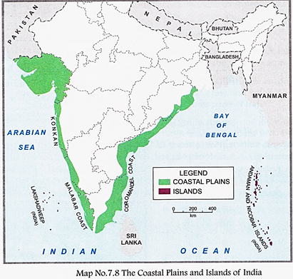
THE COASTAL PLAINS AND GHATS
The coastal plains represent a narrow stretch of plains from north to south along Bay of Bengal in the east and Arabian sea in the west. The other side, where the land rises abruptly forms the ghats.
The Western Coastal Plains lying between the western ghats and the Arabian Sea stretches from Kutch in the north to Kanyakumari in the south. The western coast is known as the Gujarat Coast in Gujarat, the Konkan Coast in Maharashtra stretching from the Gulf of Khambat to Goa, and
the Malabar Coast in Kerala stretching from Goa to Kanyakumari.
The Malabar Coast has a number of short streams, \[laggo{{n}^{6}}\] and\[backwater{{s}^{7}}\]. The Konkan Coast is broader and the largest sea port of India, Mumbai is located here.
The Eastern Coastal Plain lying between Bay of Bengal and Eastern Ghat is wider and more level than the western plains. It extends from the mouth of the Ganga to Kanyakumari. The northern half is called the Northern Circars, and the southern half is known as the Coromandel Coast in Andhra Pradesh and Tamil Nadu. The coastal strip possesses the fertile deltas of the Kaveri, Krishna, Godavari and Mahanadi rivers. There are also several lakes on the eastern coast?Lake Chilka in Odisha and lakes Kollery and Pulicat in Andhra Pradesh.
The Western Ghats (915 to 1,220 m high) known as Sahyadri in Maharashtra, are formed by the Nilgiri and the Anaimudi hills in Tamil Nadu, and the Cardamom hills in Kerala. The Eastern Ghats, with an average height of about 610 m are lower in elevation and stretch from
West Bengal in the north through Odisha and Andhra Pradesh to Tamil Nadu in the south. The Eastern Ghats are broken by valleys and they gently merge with the eastern coastal plains.
INDIA'S ISLAND CHAINS
Off the coast of the land lie a string of islands- the Lakshadweep in the Arabian Sea and the Andaman and Nicobar Island in the Bay of Bengal.
Geography Reveals
On April 10, 1991, Indians only volcano erupted in the Barren Islands in the Andamans after lying dormant for over 200 years.
Lakshadweep meaning a 'hundred thousand islands' is a group of 36 coral islands in the Arabian Sea, the west coast of Kerala. The islands with the total land area of 32 sq km form the smallest union territory of India. Ten of the islands are inhabited. Minicoy with an area of about 5 sq km is the largest island in the Lakshadweep group.
The Andaman and Nicobar archipelago is a string of 572 islands lying in the Bay of Bengal.
Andaman and Nicobar Islands are separated by a sea known as the Ten Degree Channel.
The sea coincides with the 10°N latitude, hence the name.
Only 36 of these islands are inhabited, out of which 24 are in Andaman and 12 in Nicobar. Cost of these islands are mountainous and are covered with thick forests.


You need to login to perform this action.
You will be redirected in
3 sec

