Notes - Weather And Climate
Category : 7th Class
Weather And Climate
In the previous chapter you learned about the atmosphere. You know that it keeps on changing every moment and is never static. Any change in the atmosphere gets reflected in the weather of a place. In this chapter, you will learn about the elements of weather and the factors that affect these elements.
WEATHER AND CLIMATE
We have learned that the temperature varies in each layer of the atmosphere. However, the temperature of the earth is mostly related and affected by the lowest layer of the atmosphere, that is the 'troposphere'. In this layer, all th phenomenon of the weather occurs. Thus, this is most active, effective and volatile layer. Also, the weather in turn is affected by the amount of moisture, air pressure, temperature and movement of air. Whenever these features of the atmosphere change, it results in the change of weather conditions. Weather is the condition of the atmosphere at a particular place over a short period of time. Climate, on the other hand, is the average weather conditions over a longer period of time, say over a period of 20 to 30 years.
ELEMENTS OF WEATHER AND CLIMATE
Atmospheric temperature, air pressure and precipitation are different aspects that control weather conditions. Thus the various elements of weather are?temperature, air pressure, wind, cloud, moisture, rain, etc.
The elements of weather can be measured and recorded at a weather station. People who study weather are called meteorologists. Weather reports are prepared by the meteorological department. They use various instruments such as barometers, thermometers, wind vanes and radars, to gain information about the weather.
Daily readings of instruments recording the various elements of weather are taken every 24 hours. Satellites hovering over the earth send
|
Weather |
Climate |
|
1. Weather refers to the general atmosphere conditions of a day. 2. There can be multiple weather conditions in a day. 3. It is the average record of atmospheric temperature, atmospheric pressure and rainfall over a small area on a daily basis. 4. Weather is described as hot, cold, sunny, cloudy, windy, calm, wet and dry.
|
1. Climate is the total sum of weather conditions and variations over a long period of time. 2. Climate conditions take years to change. 3. It is the aggregate of atmospheric temperature, atmospheric pressure and rainfall over a large area over 30 years or more. 4. Climate is described as equable, extreme, tropical and temperate.
|
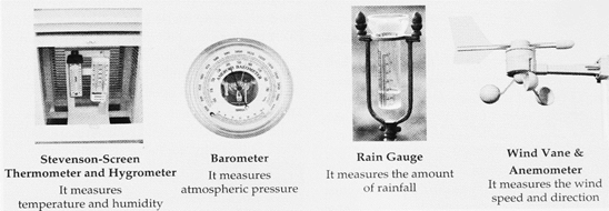
Various weather instruments
Activity
Read the given weather report from the newspaper. What are the different aspects of weather which are mentioned in the report? Record the weather report of one week and have a discussion in the class. Discuss about the maximum and minimum temperature, amount of rainfall, moisture, etc.
WEATHER
?Max 34.-TC (-2)/Min 19.6°C (0) Moonrise: Sunday - 9.38 pm, Moonset: Monday - 8.01 am Sunset: Sunday - 6.45 pm. Sunrise: Monday - 5.58 am mainly clear sky. Maximum and Minimum temperatures on Sunday will be around 35°C and 22°C. Max. Humidity on Friday was 56% and Min. 24%.
Back images of weather conditions on the earth from space and this information is recorded on weather maps and synoptic charts to obtain a weather forecast.
TEMPERATURE
Temperature can be defined as the degree of hotness or coldness. Temperature of the atmosphere changes not only during the day and night, but also from season to season. Temperature is recorded in the shade-in a Stevenson's Screen-by the maximum, minimum Six's thermometer (highest and lowest
Geography Reveals
Anders Celsius invented the Celsius thermometer. On the Celsius thermometer, the boiling point of water is 100°C and the freezing point is 0°C. The Fahrenheit thermometer was invented by Daniel Gabriel Fahrenheit. On this scale, the boiling point of water is 212°F and the freezing point is 32°F.
Temperature in 24 hours). It is recorded in degree Centigrade or Celsius (°C) or Fahrenheit (°F). Incoming energy from the Sun also known as insolation2 first heats up the earth's surface and then, the heated surface in turn warms up the air above it. Layer by layer, the air is slowly warmed up. There are multiple factors that affect the amount of insolation received by the earth surface and as a result temperature varies at all the places. Some of them are given below:
Factors affecting temperature
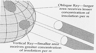
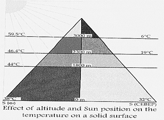
Latitude-the insolation decreases from the equator towards the poles due to the curvature of the earth and angle of the Sun. At the equator, the Sun is overhead so its heat is concentrated on a small area. Towards the poles the Sun shines at an angle. The solar energy spreads over a larger area and the temperature is lower.
Q. How does the air get heated up?
Altitude-Temperature decreases with altitude. With increasing altitude air becomes less dense and contains less dust and water vapour. Heat, therefore, is able to escape more rapidly thereby lowering the air temperature. Temperature decreases at the rate of l °C with every 166 metres of ascent, this is called the Lapse rate.
Vegetation-Trees and plants have a cooling effect on the atmosphere. Therefore, forested and grassy areas are cooler.
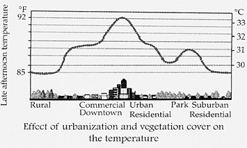
Urbanization-At night in cities and towns, the concrete and metal and glass covered high rise buildings, asphalt roads and paved areas give off heat they stored throughout the day. Therefore, night temperatures are higher here than in villages and open places.
Distance from water bodies-Areas closer to water bodies such as lakes and seas have a cooling effect. This is why, coastal areas are cooler.
Discuss
Now can you explain why on an average day, it is usually cooler in the morning and evening and hotter in the afternoon?
AIR PRESSURE
Air presses on our bodies with great force. However, we don't feel it. This is because the air presses us from all directions and our body exerts a counter pressure. Air has weight and exerts pressure on the earth's surface.
This is collectively known as air pressure or atmospheric pressure.
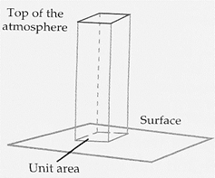
Atmospheric Pressure is the pressure exerted by the air column on unit area
The density and pressure in the air decreases with altitude. Therefore, the pressure near the earth's surface is greater than that in upper regions of hills and mountains. Air pressure can be recorded using a Mercury (Hg) 3 or Aneroid Barometer. Temperature and air pressure have inverse relationship. When temperature is high pressure is lower and when temperature is low pressure is higher. Areas with low temperature have cold air. Cold air is heavy and it sinks while warm air is light and it rises. This variation causes air to move, which we name as wind. There are four pressure belts on the earth. Equatorial low pressure and Polar high pressure belts are thermal; while Subtropical high pressure and temperate low pressure belts are formed due to dynamic reasons.
Air pressure varies with:
· Temperature-Hot air is tighter, hence it rises creating areas of low pressure; heavier, colder air descends creating areas of high pressure.
· Altitude-As the atmosphere becomes thinner, pressure decreases.
WIND
The moving air is called wind. There is uneven heating on the surface of the earth by the Sun. Some parts of the earth receive direct rays from the Sun and are warmer. Other places receive slanting rays, and hence are cooler. Warm air which is above the warmer part of the surface of the earth is lighter than cold air, hence rises.
This creates a low pressure area. Then cool air moves towards the low pressure area. This movement of air causes the wind to blow. The greater the difference in pressure, the stronger the winds blow. Gentle moving air is called breeze. The Wind Vane is used for knowing the wind direction and the Anemometer is used to measure the wind speed.
Geography Reveals
Wind blows in a particular direction and is named after the direction from which it blows, for example, if it blows from the east?it is called easterly.
TYPES OF WIND
Winds can be broadly divided into four types:
1. Seasonal Winds?Land & Monsoon wind, Sea breeze, etc.
2. Local Winds?Loo, Foehn, Chinook, Mistral
3. Variable Winds?Cyclone, Anticyclone
4. PermanentWinds?Trade Wind, Westerlies' and Polar Wind
Seasonal Winds
Sea breeze and land breeze-on a warm summer day, uneven heating of land and sea leads to the development of a local wind called sea breeze. While a land breeze occurs as the land cools faster at night than the sea.
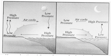
Uneven heating of the earth causes land and sea breezes
Monsoon winds?Monsoon winds that you experience during June to September in India are actually land and sea breezes on a larger scale. In summer the landmasses warm up faster and the air over the land gets heated and rises creating a low pressure area. Winds from the oceans blow onto the heated continent. These are the south west monsoon winds. In winter cold and dry air flows out of the land to the sea. This is retreating monsoon.
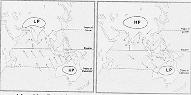
Map. No. 5.1 Advancing and Retreating
Permanent Winds
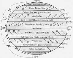
Some winds blow constantly in a particular direction throughout the year. These winds are known as planetary or permanent winds. You already know that the equatorial region is hotter than the polar region and forms the low pressure belt. Cold air from polar high pressure belt rushes to fill up low air pressure area, and a cycle develops causing winds. However, the wind does not always blow from polar region to the equator. The earth rotates from west to east, dragging the atmosphere with it. This causes the wind to deflect and create certain permanent winds in various directions. The Trade winds. Polar winds, and the Westerlies are the main planetary winds.
Permanent winds blow between these major pressure belts of the planet.
Pyessure belts and plancetary winds
Trade winds-Trade winds blow from the sub- tropical high pressure belt to Equatorial low pressure belt. In the Northern Hemisphere, the winds, because of the earth's rotation are deflected to the right. They are called the North-
East Trade winds and form the North-East Trade wind belt.
In the Southern Hemisphere, the winds are deflected t the left and are known as the South- East Trade Winds. The place where the North- East Trade Winds and the South-East Trade winds meet is a calm place called doldrums.
Westerlies-The Westerlies blow from the sub- tropical high pressure belt to the temperate low pressure belt. Surface winds from the sub-tropical
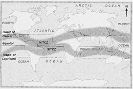
Mop No. 5.2 Doldrum belts or Northern and Southern Inter tropical convergence zones
High Pressure (Horse Latitudes) move polewards towards the temperate low pressure belt at 60° North and South latitude. In the Northern Hemisphere, they come from the south-western direction and are known as the South Westerly Winds. In the Southern Hemisphere, they are the North Westerly winds.
Polar Winds-Polar winds blow from the polar high pressure belt to the temperate low pressure belt. The low pressure belts in temperate latitudes around 60°N and S latitude are the result of cyclonic depressions because cyclonic uplifts result in relatively low pressure. We will read about cyclones later.
Winds blow from the Polar high pressure belts at the North and South poles due to extremely low temperature in these areas.
Local Winds
These winds are localised over small areas and can be warm winds like the Chinook, in USA and Canada, Foehn in the Alps and Loo blowing in summers in north India or cold winds like Bora, Mistral and Pampero. The Chinook winds blow down the leeward side of the Rockies in early spring and melt the snow of the wheat growing areas of Canada and USA-the prairies. The Mistral blows down the Rhone Valley towards the Mediterranean Sea and the Bora comes down from the Alps towards Italy, lowering winter temperatures.
Variable Winds
Variable winds like - tropical and temperate cyclones and anticyclones vary in speed, time and blow over small areas.
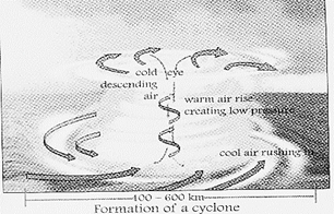
Cyclones-a cyclone is a huge storm that originates at sea. It is characterised by a low pressure canter and strong winds spiraling inward and upward. They develop in the trade wind belt between latitudes 5° and 20° north and south of the equator.
Anticyclones-In anticyclones, the air is sinking and warm. As warmer air can hold more water vapour, clouds are unlikely to form. Anticyclones can become stationary, giving settled weather, clear skies and calm winds.
MOISTURE
The amount of water vapour present in the atmosphere is known as humidity. The amount of water vapour that air can hold varies with temperature. The warmer the air, the more water vapour it can hold. When warm, moist air cools, it sometimes reaches a point where it can no longer hold all its water vapour. Then the air becomes saturated.
ODISHA?VICTIM OF NATURE'S CYCLONIC FURY
Odisha on the east coast of India is prone to cyclones which originate in the Bay of Bengal. On the 17th and 18th of October 1999, Odisha's five districts were hit by a violent cyclone. The wind speeds were up to 250 km per hour and it lasted for over 36 hours. Heavy rains lasted for 3 days. The tidal surge was 7 to 10 metres high which swept 20 km inland, together with the strong winds and heavy rainfall, devastation was caused on a massive scale to over 2UO lakh hectares of land.
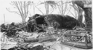
Another cyclone originated in the Gulf of Thailand, east of Port Blair a few days later on 25th of October and hit the area between Erasawa and Balekuda on October 29th. This super cyclone swept the entire coast of Odisha, including the cities of Cuttack and Bhubaneswar and 28 other towns. Over 13 million people were affected and over 10,086 people lost their lives, farmland came under water, livestock perished and property and industrial areas were damaged. Power supply and telecom lines snapped, drinking water was contaminated and severe shortage of food and basic medicines was witnessed. Due to salination caused by tidal surges, large tracts of agricultural land were rendered infertile. Forests and plantations of Sal, Teak and Bamboo disappeared. The mangrove forest between Paradeep and Konark vanished. The damage was colossal and it almost broke the backbone of Odisha.
Saturation can be defined as the condition where a mass of air can no longer hold the moisture at a given temperature and pressure. On further addition of moisture, vapour condenses to form clouds, mist or fog. The temperature at which saturation takes place is called the dew point.
CONDENSATION
Water vapours being lighter reach high up in the sky. Cool air cannot hold as much water vapour as warm air, so the vapours condense. They cluster around the dust particles present in the air and form big masses called clouds. A cloud is a visible mass of water droplets or frozen ice crystals suspended in the atmosphere above the surface of the earth. While a majority of clouds form in the troposphere, there are occasions where clouds in the stratosphere and mesosphere are observed. The amounts and types of clouds cannot be measured by instruments, so meteorologists record them by observation.
Clouds can be classified on the basis of their height, shape and form. According to height,
Clouds are of three types: (i) high, (ii) medium, and (iii) low. On the basis of their form and shape they are (a) Cirrus, (b) Alto and (c) Stratus.
PRECIPITATION
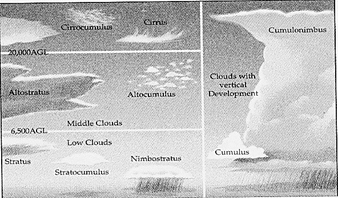
Types of clouds
Precipitation is any form of moisture which falls on the earth. This includes rain, snow, hail, sleet, fog, mist, dew, frost, etc. Most of the groundwater comes from rainwater. When the moisture in theair condenses closer to the ground and mix with dust in the air, it forms mist and fog. When a warm moist air mass blows over a cold surface (usually snow or ice, or over a cold ocean surface) it causes fog. Thick fog can reduce visibility only up to few feet?s. Mist is a thin fog resulting from condensation in the air near the earth's surface. When the water vapour in the air cools down it condenses to form, dew drops on the grass. Snow is a form of crystalline ice consisting of a multitude of snowflakes that fall from clouds. It forms in cold regions where the temperature of the atmosphere is below 0°C.
Sleet are transparent icicles resulting from the freezing of rain drops or freezing of melted snowflakes. Hail is a form of solid precipitation which consists of balls or irregular lumps of ice. Individually these balls are called hailstones.
Frost consists of ice crystals which are deposited on cool surfaces when temperatures are below freezing point in calm atmospheric conditions.
Rain
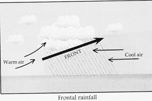
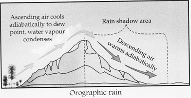
When the clouds reach high altitudes or are forced to rise due to high mountains, they change into water droplets forming rain. Rain is the most common form of precipitation and the ultimate source of pure water. This is the stage when earth receives back the maximum amount of water, and completes the water cycle. Rainfall is measured by a rain gauge. There are three types of rainfall: (i) Convectional rain, (ii) Cyclonic or Frontal rain and (iii) Relief rain or Orographic.
Convectional rainfall is due to intense solar heating of the land surface. Warm air rises forming convection current. When dew point is reached, large cumulonimbus clouds are formed.
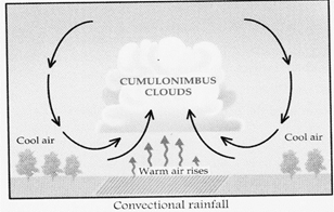
Heavy rain occurs accompanied by thunder and lightning. It commonly occurs in warm, heated areas of the world in the equatorial and tropical regions and in temperate areas in summer.
Frontal rain occurs due to the meeting of warm and cold air mass. The point where the warm mass of air meets the cold air mass is called a front. The warm air mass is forced to rise over the cold air mass and get cooled. Water vapour condenses to form rain. This type of rainfall is more common in the tropical and temperate zone. It is associated with cyclones in the tropical region and depressions in the temperate zone.
Relief or orographic rain occurs when onshore moisture laden winds are forced to rise due to a hill or mountain range. As the air rises, it cools and condenses. Clouds form and precipitation occurs on the windward side. The leeward side is the rain shadow area. Here, the descending winds are warmer with hardly any moisture-hence little or no rain.


You need to login to perform this action.
You will be redirected in
3 sec

