Notes - Natural Resources-Land, Soil, Water, Natural Vegetation and Wildlife
Category : 8th Class
Natural Resources-Land Soil, Water, Vegetation and Wildlife
We have learned in the previous chapter that land, air, water, sunlight, soil, minerals, natural vegetation and wildlife; are all natural resources. Since early days, man lias been using these resources for his survival and development. Trees have been felled to provide wood, cellulose, paper, resins, medicines, etc. Wind, sunlight, running water, etc., have been used to extract energy from them. Domestication of animals changed man's life too. In this chapter, we will read in detail about these natural resources and how they help us.
LAND
Land is the most important natural resource. It supports all living organisms including plants and animals. All our needs are fulfilled through land. We make our houses, grow crops, develop transport etc. on the land. However, the earth has a limited supply of land. Only about 30 per cent of the earth's surface is land, and a small percentage of this land can be used by people. This scarcity of land makes it a resource.
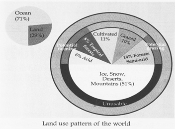
If you look at the figure given below, you will notice that most of the world's land is not suitable for our use. Some regions are too hot, or too cold or too dry. Others are mountainous or covered by swamps and forests. Thus, not more than 20 per cent land is available to satisfy our various needs.
Q. why is there such a small percentage of usable land available to us?
Land can be classified on the basis of ownership as private land and community land. Private land is owned by individuals whereas community land is owned by communities for common use. The community land is also called common property resource.
As the world's population increases and the economy expands, the demand for land increases. Therefore, we find ways to increase the supply of usable land to meet the growing needs. For this, we make better use of the existing usable land. The land supply can be increased by land reclamation.
Land Reclamation, is the process to create new land from sea or riverbeds. This is done by draining swamps, restoring derelict land and creating new land by landfill methods.
Fact File
The world is losing 0.64 hectare of forest land and adding 2.8 people every second? In the last century, we had lost 58,000,000 km2 land due to deforestation and 55,000,000 km2 land due to improper agricultural practices!
LAND USE
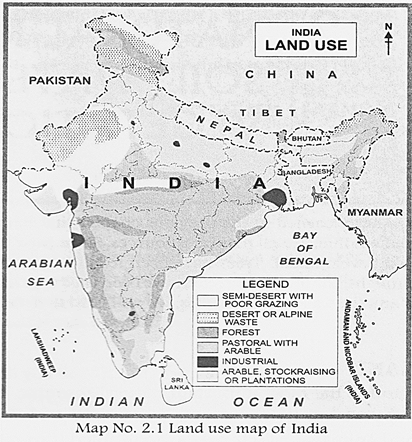
Land use simply means "how we use our land". We use land for?agriculture, grazing, industry, transport and settlement purposes. All of these are land use types. Land use changes with time because our requirement and ability to utilize various resources also gets changed. Earlier earth was in a natural form, full of forests, deserts, rivers, lakes and grasslands only. As it was humanized, man started using land to satisfy his various needs. First, he started agriculture, then he made settled homes, domesticated animals and got civilised. Later on, mining and industries also followed. As technology evolved, not only requirement for more resources arose, but their availability and utility also increased. Today man is using land for new purposes like?for dumping wastes, for testing nuclear weapons, for entertainment and recreation, etc. Thus, land use never remains the same. It is an ever changing and evolving process. Land use is determined by physical factors like?mountains, rivers, deserts, topography, soil type, climate and availability of mineral resources. You can easily correlate the land use practice of any region of India with these physical features with the help of the given map.
|
Land use (in percentage) |
||||
|
Serial No. |
Country |
Agricultural land |
Forests |
others |
|
1 |
Australia |
53% |
19.3% |
27.3% |
|
2 |
Brazil |
32.9% |
61.9% |
5.2% |
|
3 |
Canada |
6.8% |
34.1% |
59.1% |
|
4 |
China |
54.7% |
29.9% |
57.8% |
|
5 |
France |
52.7% |
29.9% |
18.1% |
|
6 |
India |
60.5% |
23.1% |
16.4% |
|
7 |
Japan |
12.5% |
68.5% |
19% |
|
8 |
Russia |
13.1% |
28.7% |
10.6% |
|
9 |
U.K |
71% |
11.9% |
17.1% |
|
10 |
U.S.A |
44.5% |
33.3% |
22.2% |
Land use pattern in various countries
LANDSLIDE
The term 'landslide' refers to the downward movement of a large mass of soil, mud, rocks and organic debris. Areas with steep slopes, for example, in hilly and mountainous regions; are particularly susceptible to landslide hazards.
Causes of landslides
The primary cause of landslide is the influence of gravity acting on a material that has weakened slopes. While some landslides occur slowly over time e.g., land movement of about a few meters per month. The most destructive ones happen suddenly after heavy rains, a cloud burst or as earthquake. Man and his activities such as deforestation, vegetation removal/ droughts, fires and logging, blasting of rocks to construct roads in mountainous areas have been associated with an increased risk for landslides.
Landslide mitigation
Mapping of areas which are prone to landslides is required so that building of settlements, roads, etc. avoided in that region can be. Diverting the discharged water away from the slopes by constructing gutters and using sandbags. Planting trees and small shrubs on the slopes as roots hold the soil. Retaining walls of concrete, wood or stones can be constructed. Sea walls along the coast where the coast is subjected to sea waves.
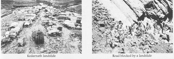
Landslide?Tragedy of Kedarnath
In June 2013, a cloudburst centred over the north Indian state of Uttarakhand caused devastating landslides/ debris flows and floods. The construction of 70 hydroelectric power projects upstream caused the blocking of rivers by their debris/ which caused major over flow by torrential rains. This caused the built up areas just above the river bed and roads to collapse and villages were washed away downstream. More than 5/700 people were presumed dead. It was the peak tourist season with pilgrims visiting the 'Char Dhams'. Destruction of bridges and roads left about 100/000 pilgrims and tourists trapped in the valleys. The Indian Air Force, the Indian Army and Paramilitary troops evacuated more than 110,000 people from this area.
OPTIMUM LAND UTILIZATION
The land used for growing crops is known as arable land. Only 11 per cent of the earth's surface is used as arable land. The rest is either too cold, too dry, mountainous or the soil is very poor for farming. Land productivity can be increased by terracing/ irrigation or by using fertilisers.
Terracing
Steep slopes can be terraced to increase arable land. Horizontal steps are made into the slope and the edge of the terrace has mud or stone walls to retain water or slow down the runoff and prevent soil erosion. These terraces allow the use of machinery for cultivation.
Irrigation
This is the practice of supplying water to land through rivers, streams, underground water, wells or bore wells. It is practised in areas where rainfall is unreliable or seasonal, as in India. The Indira Gandhi Canal in Rajasthan has made farming possible there. In China and Japan, crops can be grown twice a year. Because of irrigation only.
Using fertilisers
Fertilisers are used to increase the fertility of land, to enable crops to grow better and produce a higher yield. Nitrogen, potash, sodium and phosphate are common fertilizers.
LAND DEGRADATION
Land degradation refers to the decline in the productivity of cultivated and forest land. The change in the characteristics and quality of soil, that adversely affects its fertility, is also termed as land degradation. It is hard to separate soil and land from each other. It is estimated that 40 per cent of the world's agricultural land is seriously degraded.
Causes of land degradation
Man himself and his activities are the prime cause of land degradation. In process of claiming more and more land for his use, and optimizing present land under cultivation; man destroyed his prime resource. Deforestation, over grazing, development of transport and movement of people and cattle, result in reduced growth of vegetation, decreasing flora and fauna diversity, soil depletion and land degradation. Modern agricultural practices such as?excessive use of fertilizers and pesticides, monoculture of certain crops (for example cotton and sugar cane); degrades the quality and fertility of the soil. Contamination of soil from chemical fertilizers, factory runoff, garbage dumps and mining are a few other causes of land degradation which pollute water bodies and soil, both.
Conservation of land resource
Following these measures leads to land conservation:
? Maintaining ecological balance of nature.
? Afforestation and minimised deforestation.
? Controlled grazing of livestock and cattle.
? Digging deep for dumping solid wastes. Avoiding overuse of pesticides, insecticides and fertilizers.
? Increasing and promoting use of organic fertilisers and manure. Setting up of processing and filtering units in large industries to treat and segregate the toxic, non-toxic and organic wastes before dumping them in the ground or water bodies.
? Using the land according to land use capability.
? Covering the fallow land and landfills with dry leaves and other organic waste
SOIL
Soil is a thin layer of material covering the earth's surface. Soil has all the properties to sustain life. It has water available for plants and animals and air spaces for them to breathe. Thus, soil is a habitat of many species of animals and plants. It forms a firm and good support to plants, which gets rooted in it. It supplies various nutrients to plants which are essential for their growth. Insects, reptiles, microorganisms and even some rodents have their homes in the soil.
FORMATION OF SOIL
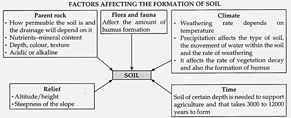
Earlier the earth's surface was made of huge blocks of hard and solid rocks. The surface rocks broke down into smaller pieces through the process of weathering, forming stones and pebbles. This process further formed grains of soil. When plants and animals died, they got decomposed by the action of a few microbes like bacteria. The weathered rocks then got mixed with dead and decaying plants and animals and formed soil. Soil formed the outermost layer of the earth's crust. This process of weathering of rocks is still going on and soil is continuously being formed. However, the process is very slow and takes a long time. Even an inch of soil takes 1000 years to form. Factors affecting the formation of soil are as follows? (i) Parent rock, (ii) Climate, (iii) Relief, (iv) Flora and fauna and (v) Time All these factors are closely interconnected and dependent on each other.
SOIL PROFILE
The soil profile is a vertical section below the earth's surface that shows different layers, known as horizons. Soil scientists use the capital letters O, A, B, C and R to identify the horizons.
O-horizon is the top, organic layer of soil, made up mostly of leaf litter (decomposed organic matter). This organic matter decomposes to form humus. Humus gives the soil a dark colour. It is rich in nutrients and good for crops.
A-horizon is found below O-horizon and is called the topsoil. It consists of fine particles and is soft and porous and can hold water. Most seeds germinate and plant roots grow in this dark-coloured layer. It is made up of humus (decomposed organic matter) mixed with mineral particles.
B-horizon is called the subsoil. It contains sand, silt and clay and has a rich deposit of minerals. It has been observed that roots of plants reach only till this layer.
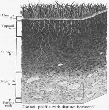
C-horizon, also called regolith, is beneath the B-horizon and above the R-horizon. This layer of soil consists of slightly broken up particles of the parent rock and is called bedrock. Lant roots do not penetrate into this layer and very little organic matter can be found in this layer.
R-horizon is beneath all these layers. This zone is where the parent rock or the bedrock is found. The bedrock is the unweathered rock that determines soil characteristics.
SOIL DEGRADATION
The soil that covers the surface of the earth, i.e., the top soil which is the fertile part is carried away by strong winds, rainfall, etc. This is called soil erosion. Soil erosion makes the land barren.
Activity
Visit a site where the soil has been dug for making a ditch. The soil is not similar when you dig into the ground. Observe. You can see distinct layers of soil.
Causes of soil degradation
Due to overgrazing by animals:?Animals eat away the grass which holds the soil. This leaves the soil exposed to the agents of weathering.
Deforestation:?He rising rate of deforestation has increased soil erosion. More and more trees are being cut to build houses, roads, bridges and dams. We must take steps to prevent soil erosion by planting more trees. Tree roots help to hold the soil together. This stops rain water and wind from carrying away the top soil.
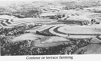
Improper methods of cultivation:?ploughing up and down on slopes increases surface run-off. Thus, contour and terrace farming is an effective method to check soil erosion in the hills.
Natural agents:?Heavy rains, landslides and floods are the natural causes of soil erosion.
Soil Conservation
If carefully managed, soil is a sustainable resource. Soil which has taken centuries to form, can be lost in no time if not carefully managed. Various techniques of preventing and minimizing soil erosion are as follows:
Contour farming:?on gentle slopes, crops are grown in rows across the slopes. This practice is known as contour farming. Each row planted horizontally along the slope of land acts as a small dam to conserve soil and slow down its loss.
Terracing:?on steeper slopes, a series of terraces or steps are made. Terracing retains water for crops at all levels and cuts down soil erosion by controlling run-off. In some areas, ditches are also provided behind the terraces to allow drainage.
Crop rotation:?this is an agricultural practice to maintain soil fertility. It involves the growing of two or more crops alternately. It maintains the mineral content of the soil and retains its fertility.
Afforestation:?erosion of soil by wind can be prevented by planting trees (afforestation). Trees act as wind breakers and also check the advancement of deserts towards fertile land.
Shelter belts:?in the coastal and dry regions, rows of trees are planted to check wind speed to protect soil cover.
Intercropping;?Different crops are grown in alternate rows and are sown at different times to protect the soil from being washed away by rain.
Mulching:?by covering bare ground between plants with a layer of straws helps in retaining soil moisture.
Contour barriers:?stones, soil, etc. are used to build barriers along contours. Trenches are made in front of the barriers to collect water.
Rock dam:?rocks are piled up to slow down the flow of water. It helps in preventing soil loss and formation of gullies.
WATER
Water is one of the common substances found on the earth. It covers more than 70 per cent of the earth's surface. It is present in the air around us in the form of water vapour. About -97 per cent water present on the earth is found in oceans and seas and 2 per cent is stored in ice and snow. Sea water and ocean water is too salty to be used for drinking and farming purposes. It cannot be used in the manufacturing processes as well. The total amount of fresh water available for use by human beings and other living organisms is only 1 per cent. Fresh water is therefore the most precious substance available on earth. Rainwater is the purest form of natural water. Rainwater acts as a natural sprinkler for irrigation. In our country, agriculture depends upon rainwater to a large extent. Rain brings water back to the earth and water bodies get filled up. Thus, we have lakes, ponds and rivers which form the surface water. Some rainwater seeps through the soil and gets collected above layer of impervious rocks. This forms a sort of large water body under the ground. This is groundwater. This water is safe for drinking. When groundwater comes out with pressure through an opening on the earth's surface it forms a spring. Salts and minerals are generally present in spring water. It is mostly groundwater that reaches our bathrooms and kitchens through taps. Groundwater can also be brought out through tube wells and used for various purposes.
WATER CRISIS
Water once considered an inexhaustible natural resource has now been labelled as 'a scarce resource'. The reasons are as under:
Unequal distribution of rain:?the rainfall pattern and distribution in a region is a good index of its water sources. Coastal areas receive heavy rains while deserts have scanty rains.
Groundwater depletion:?Groundwater is a major source of fresh water. However, it is limited in amount and gets depleted if the rainfall is scanty. It also gets affected due to wrong practices by us. Urbanisation, industrialisation and to some extent, the green revolution also has increased the demand for water. Uncontrolled use of bore well technology, deforestation and improper management of water resources are responsible for the depletion of underground water.
Groundwater contamination:?excessive application of chemical fertilisers in the fields pollute the soil. These pollutants also seep through the soil and pollute the groundwater as well. Water pollution is one of the main cause of our water crisis.
Surface water depletion:?when it does not rain for a long period of time, rivers, ponds and lakes dry up due to evaporation. The Yamuna has also receded and in Delhi, the slums built on the river bed is an example of depletion of surface water.
Surface water contamination:?waste water from our bathrooms, kitchens, industries and agricultural fields (carrying chemicals) run into ponds and rivers and make them unfit for use.
Water Crisis in India
The annual average rainfall in India is about 120 cm, i.e., slightly more than the global mean of 99 cm; but there is extreme regional variation in rainfall. The Khasi hills in the north-east get an average annual rainfall of more than 1,000 cm, whereas the average annual rainfall received in parts of the Rajasthan desert is even less than 15 cm. Nearly 75 per cent of the total rainfall is due to the monsoon from June-September.
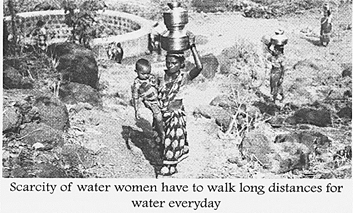
Even in this season, the rainfall in most parts of the country is uncertain. India's production of rice, corn, cotton and oilseeds depend on this monsoon. The uncertainty in the monsoon characterised by prolonged dry spells often leads to failure of these crops, which in turn, leads to drought, food shortage, famine and rise in food prices. Thus, agriculture in India suffers due to its dependence on rain. Scarcity of drinking water is commonly seen in the remote villages of Rajasthan, Odisha and Madhya Pradesh; where people have to go long distances to fetch water for their daily needs. Today, the Indira Gandhi Canal in North India brings water to the Thar Desert of Rajasthan from the river Sutluj.
WATER CONSERVATION
With more and more areas struggling with droughts, water conservation is now more important than ever before. Even if you are not living in a drought prone area, cutting back on water usage helps in saving precious and dwindling resource of water. We can conserve water by minimizing its wastage and improving our habits. Around the home, start with a few on the list.
Alarming facts
? The UN has estimated that 25,000 people die from using contaminated water every year. It estimates that by the year 2050, two- thirds of the world population, mainly of the LEDCs, i.e., Africa, Asia and Latin America; are likely to be short of clean water!!
? Water Scarcity in 2016 was the worst in a decade. There were severe droughts in UP, Kamataka and 28,000 villages of Maharashtra were affected.
? Turn the tap off while brushing your teeth or scrubbing your hands.
? Fix leaking faucets and pipes.
? Cut your showers shorter.
? Dish washers and washing machine should be fully loaded then switched on.
? Switch off lights and fans when not in use you save water...hydroelectricity.!!! watering the plants early morning or late in the evening causes less water evaporation.
? Install a water barrel or tank to collect rain water for watering plants and lawns.
? Use sprinklers for irrigation.
? Rain water harvesting system should be installed at each house or housing complex to help in penetration of water in to sub-layers and increase water level of the underground water.

NATURAL VEGETATION
Natural vegetation refers to plant communities growing naturally without human aid and have been left undisturbed by humans for a long time. Wildlife refers to all animals-mammals, reptiles, birds, insects, amphibians, aquatic life
Forms-in the natural, undomesticated state. Natural vegetation and wildlife exist only in the narrow zone of contact between the lithosphere, hydrosphere and atmosphere which is known as biosphere.
The nature of plants in an area, to a large extent, determines the kind of animal life in that area. All plants and animals in an area are interdependent and interrelated to each other in their physical environment, forming an ecosystem. Humans are also an integral part of the ecosystem.
Natural vegetation and wildlife are very important natural resources. Plants provide us with timber and firewood. They also provide habitat to some animals; produce oxygen which animals breathe in; help in preventing soil erosion and replenishing the underground water; give us fruits, vegetables, resins, gums, latex, nuts, medicines and pulp for paper.
DISTRIBUTION OF NATURAL VEGETATION
The distribution of natural vegetation depends upon many factors. Some of them are land, soil, temperature, sunlight and rainfall. The major vegetation types of the world are forests, grasslands, desert vegetation and tundra vegetation.

Forests are broadly classified as evergreen and deciduous forests depending on when they shed their leaves. Evergreen forests consist entirely of evergreen trees which do not shed their leaves simultaneously in any season of the year. As a result, the forests retain green foliage all year round. These forests can be further divided into Tropical, Temperate, Mediterranean and Coniferous forests. In deciduous forests, trees shed their leaves seasonally, usually during the winter or dry season. As the amount of moisture decreases, the forests give way to grasslands and desert vegetation.
Conservation of natural vegetation
Forests are important natural resources and we must conserve them. Trees produce large amount of oxygen and take in carbon dioxide. Thus, they help in maintaining the balance in the level of oxygen and carbon dioxide in the atmosphere. Trees act as natural air conditioners. They cool the earth by giving shade. They also help in recycling water. Trees provide a protective canopy that lessens the impact of rain on the soil and thereby reduces soil erosion. Forests give us commercial products such as timber for furniture and building houses. Other
Debate
Wetlands are important natural resources. Draining these swamps may destroy a whole ecosystem. Do you think swamps should be drained? Hold a debate on it considering the economic value of both the recovered land and the ecosystem.
Products include turpentine, medicines, fruits, vegetables, rubber, paper, etc.
Forest area is disappearing at an alarming rate, mainly due to human activities. Large scale cutting down of trees is called deforestation. Soil erosion, water pollution, drought, landslides and global warming are some of the consequences of deforestation. Deforestation damages our lives and the environment. Some of the ways by which we can preserve our forests are as follows:
? Planting trees (afforestation) should be encouraged.
Causes of forest fire
Forest fire is a major threat to the natural vegetation and wildlife of a region. It occurs due to?
? Natural fire caused by lightening
? Fire caused by unknowingly thrown cigarette and matchsticks, etc.
? Fire caused purposely by local inhabitants for cleaning land, and mischief makers for covering their unlawful activities of timber and animal smuggling.
Preventive measures for forest fire
? Educate people to behave sensibly while going into the forest
? Setting up of efficient fire alarm systems and well-coordinated network of rescue teams.
? Digging firelines at regular intervals to restrain the spreading of forest fires
ACTIVITY
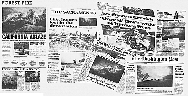
Collect more pictures and information about forest fires which occured in Uttarakhand early this year.
Fact File
Sacred Groves comprise patches of forests or natural vegetation that are usually dedicated to local folk deities. These are protected by local communities because of their religious beliefs and traditional rituals that run through several generations. In India, sacred groves are widely distributed in the states of Maharashtra, Himachal Pradesh, Kamataka,
Tamil Nadu and Kerala.
? Forest fires should be checked and controlled effectively.
? Generating public awareness to save the environment.
? Discouraging the practice of shifting cultivation.
? Preventing overgrazing by animals.
? Restricting quarrying and mining and upcoming construction.
? Encouraging awareness programmes like social forestry and Vana Mahotsava at regional and community level.
? Providing alternative source of fuel for cooking to the local people, who still use firewood.
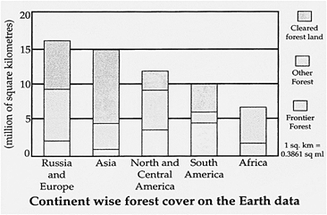
Frontier Forests is a term used for large areas which support the survival of plants and animal species.
WILDLIFE
The distribution of wildlife to a large extent, depends upon the type of vegetation growing in that area. Forests, grasslands and deserts provide habitat to animals. Animals not only live there, but they obtain food and water, grow and move freely, breed and raise their young ones. They are also protected from their predators. Wildlife help in maintaining the ecological balance. Animals are useful to us in numerous ways. They provide us with milk, meat and wool. Insects help in pollination of flowers and act as decomposers in the ecosystem. Vultures feed on dead livestock and act as scavengers, there by cleaning the environment. Plants and animals maintain a balance in the level of oxygen and carbon dioxide in nature.
DISTRIBUTION OF WILDLIFE
Wildlife of the World
Africa is rich in wildlife. Animals found in the equatorial forests are African elephants, gorillas, black colobus monkeys, hippopotamuses, African grey parrots, driver ants, okapis and chimpanzees. Deserts are inhabited by hares, foxes, jerboas, wild asses, gazelles, camels and ostriches. Leopards, lions, cheetahs, baboons, zebras, giraffes, warthogs, rhinoceroses and aardvarks are found in grasslands. The common animals found in Australia are kangaroos, koalas, wombats, kookaburras, emus, platypuses, echidnas and galahs. In South America, Andean Condor is found which is the largest flying bird. Other animals include piranha, capybara, southern right whale, anaconda, giant tortoise, dolphin, scarlet macaw, llama and penguin. Europe is inhabited by the polar bear, reindeer, walrus, wild boar, beaver, bison, moose, otter, red flamingo, arctic fox, skylark and the cuckoo. The main animals found in North America are the bison, pronghorn, brown bear, bald eagle, beaver, moose, arctic wolf, black-footed ferret, caribou and monarch butterfly. In Antarctica, seals, albatrosses, snow petrels, penguins, krills, skuas and whales are found.
Wildlife of India
The diverse terrain of India has provided shelter to numerous wild animals. Indian Asiatic lion is now confined to the Gir forests of Gujarat. Black bucks are found in parts of Punjab, Rajasthan, Haryana, Gujarat, along with a few areas in Central India. The Bengal tiger is found in the Bengal region. Other animals such as Indian black bear, camel, clouded leopard, deer, elephant, langur, leopard, macaque, red panda, rhinoceros, wild ass and wild boar are also found. Snakes, alligators and crocodiles are found in the rivers and marshes. Indian peafowl, kingfisher, Indian roller, cuckoo, great Indian bustard, grey heron, comb duck, mallard, peacock, pigeon and pheasant are some of the birds found in India.
CONSERVATION OF WILDLIFE
Conservation of Wildlife in World
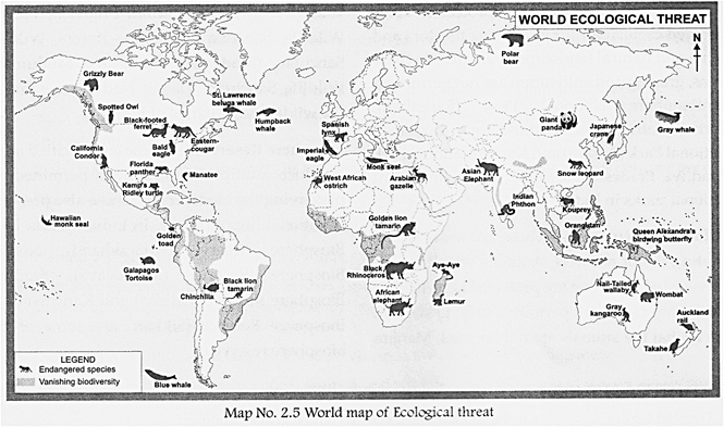
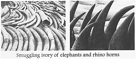
Forests are the natural homes of wildlife. Wildlife needs to be safeguarded from hunters and poachers. Body parts and derivatives of many wildlife species like rhino horn/ tiger bone and skin, ivory, shahtoosh, musk and bear bile have great value in the international market. This leads to indiscriminate poaching. As a result, many species have become vulnerable or endangered and some are on the verge of extinction. Rhino horns and ivory of Elephants are articles of trade in the world market.
World Wildlife Fund (WWF) is an international non-governmental organisation. It raises money for conservation projects in different parts of the world, with particular emphasis on endangered species and their habitats. The Convention on International Trade in Endangered Species of Wild Fauna and Flora (CITES) ensures that international trade in wild animals and plants does not threaten their survival. It gives varying degree of protection to more than 30,000 species of animals and plants, bears, dolphins, cacti, corals, orchids and aloes are some examples. The International Whaling Commission (IWC) was set up to protect whales that are almost on the verge of extinction as a result of uncontrolled whaling.
Q. Find out what UNEP does for conservation at the international level.
Conservation of Wildlife in India
The government of India passed the Wildlife Protection Act in 1972. Hunting has been completely banned. National parks, wildlife sanctuaries and biosphere reserves have been set up by the government as steps towards conserving wildlife.
National Parks:?these are protected areas reserved exclusively for preserving the flora and fauna and natural landscape of an area. In these areas, grazing and cultivation are not permitted. Ranthambore National Park (Rajasthan), Corbett National Park (Uttarkhand), Kaziranga National Park (Assam) and Kanha National Park (Madhya Pradesh) are some of the important national parks in India.
Wildlife Sanctuaries:?these are areas where hunting is not allowed. Animals which are on the verge of extinction are protected here. Private ownership rights are permitted only to such an extent that the animals are not harmed. Manjira Wildlife Sanctuary (Andhra Pradesh), Periyar Wildlife Sanctuary (Kerala), Karera Wildlife Sanctuary (Madhya Pradesh) and Mudumalai Wildlife Sanctuary (Tamil Nadu) are some of the wildlife sanctuaries of India.
Biosphere Reserves:?these are specified areas in which multiple use of land is permitted for preserving the biodiversity. These also preserve traditional life of people. In India, Nanda Devi Biosphere Reserve (Uttarakhand)/ Nokrek Biosphere Reserve (Meghalaya), Simlipal Biosphere Reserve (Odisha) and Kanchenjunga Biosphere Reserve (Sikkim) are some of the biosphere reserves.


You need to login to perform this action.
You will be redirected in
3 sec

