Water
Category : Teaching
Water
LEARNING OBJECTIVES
INTRODUCTION
Water is very vital for the existence of any living being. Almost 71% of surface of the earth is covered by water.
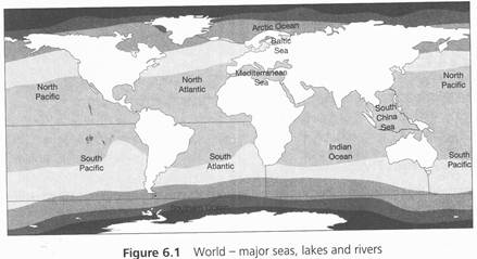
DISTRIBUTION OF WATER BODIES
The distribution of water bodies around the world is shown in Table 6.1.
Table 6.1 Water bodies and their distribution
|
Water bodies Distribution (%) |
||
|
Oceans |
97.3 (saline water) |
|
|
Ice-caps |
02.0 |
|
|
Groundwater |
0.68 |
|
|
Freshwater lakes |
0.009 |
|
|
Inland seas and salt lakes |
0.009 |
|
|
Atmosphere |
0.0019 |
|
|
Rivers |
0.0001 |
|
OCEAN
Oceans and their area are as follows:
1. Pacific Ocean - 1,662,40,000 km2 (largest)
2. Atlantic Ocean - 865,60,000 km2
3. Indian Ocean - 734,30,000 km2
4. Arctic Ocean - 132,30,000 km2 (smallest)
Ocean is the biggest part of hydrosphere. Pacific ocean is the largest ocean m the world. There are two important characteristics of ocean water: temperature and salinity. The average depth of ocean is 3 800 m. The depth of ocean is represented by hypsographic metric curve.
The part of ocean that is surrounded by water from three sides and ocean by one side is called sea The part of sea that enters into the land is called gulf. When the sea is surrounded from two sides by land, that is, one side faces a group of island and the other side faces sea, is called a bay
Table 6.2 Deepest oceans in the world
|
Name |
Deepest point (km) |
Deepest point (miles) |
Ocean |
|
Mariana Trench |
11.0 |
6.83 |
Pacific Ocean (near Japan) |
|
Philippine Trench |
10.4 |
6.46 |
Pacific Ocean (near the Philippine island) |
Table 6.2 (Contd)
|
Name |
Deepest point (km) |
Deepest point (miles) |
Ocean |
|
Bonin Trench |
9.99 |
6.20 |
Pacific Ocean (near Japan) |
|
New Britain Trench |
9.94 |
6.17 |
Pacific Ocean (near New Guinea) |
|
Kuril Trench |
9.75 |
6.05 |
Pacific Ocean (near Russia) |
Some Features of Hydrosphere
Generally, the ocean temperature remains between 5°C and 33°C. Oceans are rich sources of minerals; however, some are diluted and some are found in solid state. Some main diluted minerals are sodium chloride, magnesium chloride, sodium sulphate, and calcium. The taste of water is saline because of the composition of these minerals. Salinity differs from ocean to ocean. In one litre of water, 35% composition is salinity.
Waves and Currents
The ocean water never remains still and always in a state of motion.'It has three types of motions. The first type of motion is tide and ebb; it is systematic and continuous process of upward and downward movement of water and the basic reason of this movement is gravitational power of sun and moon. Ebb and tide do not move water per se location wise; however, it just moves it upward and downward without w changing the location. The second type of motion of water is currents. They occur due to the friction of water and air on the surface of ocean. It also does not necessarily change the location of water but it keeps the water in motion vertically. The third type of motion is ocean waves. Ocean waves are dynamic and it keeps the water in motion in one direction only. This third type of motion is important in a way that it moves the location of water. The ocean waves are the result of combination of salinity, volume, temperature, the coastal size, rotation of earth and air waves, and so on. The density of ocean water depends on the temperature and salinity of that water.
There are two types of ocean streams: warm stream and cold stream. When the temperature of stream is more than the temperature of that particular latitude is called warm stream and when the temperature of stream is less than the temperature of that particular latitude is called cold stream. In this way, the streams that flow from lower latitudes to upper latitudes are warm streams and those flow from upper to lower latitudes are cold streams. Except these streams, there are some sub-surface streams that play vital role in balancing seawater.
In the northern spheres, the streams move clockwise; while in southern spheres, the streams "We anticlockwise because of the rotation of the earth. The temperature of the ocean plays an important role in the determination of temperature of places on the earth.
Some of the most important stream sare northern and south equatorial streams. Gulf stream, Florida
stream, Brazil stream. North Atlantic Drift, and Agulhas stream; all these streams are warm in nature. Some cold water streams are Labrador Streams, Canneri stream, Benguela stream, Falkland stream Alaska stream, Peru stream, Humboldt stream , Oyashio stream and Canaries stream.
1. Streams of Atlantic Ocean: Warm streams of Atlantic ocean are northern equatorial stream gulf stream, Florida stream, southern equatorial stream, and Brazil stream. Cold streams are Labrador stream, Falkland stream, Antarctic stream, north Greenland stream, and Canneri stream.
2. Streams of Pacific Ocean: The warm streams of Pacific Ocean are Northern Equatorial stream, Sushima stream, Kuroshio stream. Northern Pacific stream, and Eastern Australia stream. Some cold streams are Alaska stream, Peru stream, Humboard stream, California Stream, and Antarctic stream.
3. Streams of Indian Ocean: Warm streams are southern equatorial streams, Agulhas stream, and Mozambique stream. Cold streams are western Australian stream. A narrow water way that joins two different gulfs, oceans, or seas is called a strait and a narrow way that joins two big landscapes is called Isthmus. For example, Gibraltar Strait that joins Atlantic Ocean with Mediterranean Sea and Panama Isthmus that connects Northern America with Southern America.
LAKES
In comparison to sea and ocean, the rivers and lakes are smaller. A lake is a trench full of water. Although the lakes do not have a flow of water, there are some exceptions too. Many lakes are formed like a river. Some of the rivers enter into lakes, whereas the others flow out of it. In comparison to lakes, the rivers have a flow.
There are several types of lakes such as man-made, natural, freshwater, and saline. Freshwater lakes are formed due to the melting of ice and it is necessary that these lakes are connected with rivers. These are found on high and medium latitudes. Some examples are Baikal, Titicaca, Wular, Dal, Manasarovar, and so on.
Salty lakes are found in the areas of high evaporation and low rainfall; further, these are not connected with any river that is why they are still. These are used in the production of salt like Sambhar Lake of Rajasthan. Some of the lakes are well-connected with the sea like Chilika Late of Orissa.
Natural lakes are made of activities of tectonic plates or crater of volcanoes. India's Lunar Lake is example of Crater Lake or natural lake. Soil erosion, river erosion, and air erosion are also cause the formation of these types of lakes. Baikal, Caspian, and death sea are examples of these types of lakes.
Man-made lakes are formed due to the multipurpose projects originating from different countries; these projects include irrigation, control of floods, and electricity production. Some of the man-made lakes such as Gobind Sagar of Bhakra Nangal and Gandhi Sagar of Chambal are formed due to the construction of dams.
Some of the famous lakes around the world are as follows:
1. Caspian Sea (Russia and Kazakhstan): 436,000 km2
2. Superior (Canada and USA): 82,100 km2
3. Victoria (Uganda, Kenya, and Tanzania): 68,870 km2
4. Huron (Canada,and USA): 59,600 km2
5. Michigan (USA): 58,000 km2
6. Tanganyika (Burundi, Tanzania, Zambia, and Congo): 32,600 km2
7. Baikal (Russia): 31,500km2
8. Great bear lake (Canada): 31,000 km2
RIVERS
A relatively constant way of water flowing in a direction is called river. Rivers are the biggest
source of freshwater. Some of the famous rivers around the world are as follows:
1. Nile (Egypt and Sudan): 4,132 miles (longest river in the world),
2. Amazon (South America): 3,976 miles
3. Yangtze river or Changjiang (China): 3,915 miles
4. Mississippi (North America): 3,734 miles
5. Yenisei (Siberia): 3,445 miles
6. Yellow river (China): 3,395 miles
7. Ob river (Siberia and Russia): 3,395 miles
8. Panama river (Brazil, Paraguay, Argentina): 3,030 miles
9. Congo river (Congo): 2920 miles
10. Amur river (Manchuria): 2763 miles
WATER RESOURCES OF INDIA
India is a developing country. It has a large population in which more than 60% of people are working under the agriculture sector. On the other hand, industries are developing very fast and becoming the backbone of India's economy. It is also a country of different climate regions. At a specific period of time, one place will be affected by flood, and the other will be suffering from drought. All these qualities of this county make it highly dependent on some natural resources and water is the most important resource among them. We use water in our agriculture and developing industries; further, we use it to fulfil the water needs of a very large population and we use it in our developing infrastructure. We are decreasing our dependency on monsoon to make sustainable development of our personal and commercial agriculture. Therefore, it is very easy to understand the importance of water resources for us. India accounts for about 2.45% of world's surface area, 4% of the world's water resources, and about 16% of world's population. The total water available from precipitation in the country in a year is about 4,000 km3. The availability from surface and replenishable groundwater is 1,869 km3. From this, only 60% can be used for beneficial purposes. Thus, the total utilisable water resources in the country are only 1,122 km3
{Unit 3, Chapter 6, Water Resources, Class 12, NCERT, pp. 60.)
Surface Water Resources
We can divide surface water resources into four major sources: ponds, tanks, lakes, and rivers. India has gifted thousands of rivers by nature. There are almost 10,360 listed rivers. From these rivers, India gets more than 1,869 km3 of freshwater. However, due to many geographical reasons, only 32% of that water can be utilised. The amount water in river totally depends upon the size of its catchment area of river basin and the amount of rainfall occurred in the area of catchment of river. Some of the Indian Rivers has huge catchment area. The Ganga, the Brahmaputra, and the Barak rivers are leading them. These rivers are the source of 60% of surface water sources of India.
Table 6.3 Basin-wise groundwater potential and utilisation in India (cubic km/year)
|
S. no. |
Name of basin groundwater resources |
Total replenishableLe utilisation (%) |
Level of groundwater |
|
1. |
Brahmani with Baitarani |
4.05 |
8.45 |
|
2. |
Brahmaputra |
26.55 |
3.37 |
|
3. |
Chambal Composite |
7.19 |
40.09 |
|
4. |
Kaveri |
12.3 |
55.33 |
|
5. |
Ganga 170.99 |
33.52 |
|
|
6. |
Godavari 40.65 |
19.53 |
|
|
7. |
Indus 26.49 |
77.71 |
|
|
8. |
Krishna 26.41 |
30.39 |
|
|
9. |
Kuchchh and Saurashtra including river Luni |
11.23 |
51.14 |
|
10. |
Chennai and South Tamil Nadu |
18.22 |
57.68 |
|
11. |
Mahanadi |
16.46 |
6.95 |
|
12. |
Meghna (Barak and others) |
8.52 |
3.94 |
|
13. |
Narmada |
10.83 |
21.74 |
|
14. |
Northeast Composite |
18.84 |
17.2 |
|
15. |
Pennar |
4.93 |
36.6 |
|
16. |
Subarnrekha |
1.82 |
9.57 |
|
17. |
Tapi |
8.27 |
33.05 |
|
18. |
Western Ghat |
17.69 |
22.88 |
|
|
Total |
431.42 |
31.97 |
|
Source: Class 12, NCERT Geography text book. Unit 3, Chapter 6, Water Resources, page 61 |
|||
Groundwater Resources
in India, we have 432 km3 freshwater resources as groundwater. However, 46% of total replenishable groundwater resources of country are shared by the Ganga and the Brahmaputra basins. As we know, we are a developing country and working hard to develop our agriculture and industries. This is the reason why utilisation of groundwater is very high in many parts of our country. The leading states where utilisation of groundwater is very high are Punjab, Haryana, Rajasthan, Tamil Nadu, Gujarat, Uttar Pradesh, Bihar, and Maharashtra.
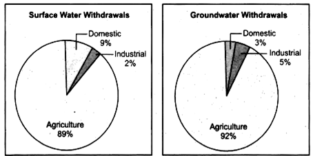
Figure 6.2 (a) Sectoral usage of surface water (b) Sectoral usage of groundwater
MAJOR RIVER SYSTEMS IN INDIA
India is the country of thousands of rivers. From north to south and east to west, there are many river systems in India. However, two major river systems are Ganges river system and Indus river system.
Ganges River System
There are many rivers in this system. The major rivers merging in this system move from west to east. The rivers are as follows:
1. Chambal
2. Betwa
3. Yamuna
4. Gomti
5. Ghaghra
6. Son
7. Gandaki
8. Koshi
9. Brahmaputra
Indus River System
It originates in the northern Kailash range near Manasarovar Lake in Tibet. The major rivers of this system are as follows:
1. Indus
2. Chenab
3. Jhelum
4. Ravi
5. Sutlej
6. Beas
7. Shyok
8. Zanskar
Famous Lakes of India
The famous lakes of India are as follows:
1. Wular Lake (Jammu and Kashmir): It is the largest freshwater lake in India. The length and width of the lake are approximately 16 km and 9.6 km, respectively.
2. Dal Lake (Jammu and Kashmir): It is located in Srinagar. It is also known as Crown of Kashmir.
3. Chilika Lake (Odisha): It is the second largest lagoon lake of the world.
4. Pangong Lake (Ladakh): It is situated at the height of about 4,350 m.
5. Sambhar Salt Lake (Rajasthan): It is the largest inland salt lake of India. It is a bowl-shaped lake.
6. Bhimtal Lake (Uttarakhand): It has a large variety of aquatic life and winter stoppage of birds from trans-Himalayan region.
7. Lonar Lake (Maharashtra): It is a crater lake.


You need to login to perform this action.
You will be redirected in
3 sec