ATMOSPHERE
Category : UPSC
ATMOSPHERE
INTRODUCTION
Atmosphere is a gaseous envelope surrounding the earth extending thousands of kilometers above the earth's surface. Life on earth exists at the bottom of the atmosphere where it meets with the lithosphere and the hydrosphere. The atmosphere directly or indirectly influences the vegetation pattern, soil type and topography of earth. About 99% of the total atmosphere mass concentrated found within 32 kms from earth's surface. The atmosphere is held close to earth because of the earth's gravity and is energized by the sun.

COMPOSITION OF THE ATMOSPHERE
The atmosphere is composed of different types of gases, dust particles and water vapour. Such compositions in the atmosphere is hot static but it changes with time. The composition of the atmosphere are as follows:
|
Component |
Percent by Volume |
|
Nitrogen |
78.08 % |
|
Oxygen |
20.94 % |
|
Argon |
0.93% |
|
Carbon dioxide |
0.03% |
|
Neon |
0.0018% |
|
Helium |
0.0005% |
|
Ozone |
0.00006% |
|
Hydrogen |
0.00005% |
STRUCTURE OF THE ATMOSPHERE
The atmosphere consists of concentric layers of gases, with varying density and temperature. Generally the atmosphere extends upto 1600 kms from the surface of the earth. On the basis of chemical composition, the atmosphere is divided into:
Homosphere and Heterosphere.
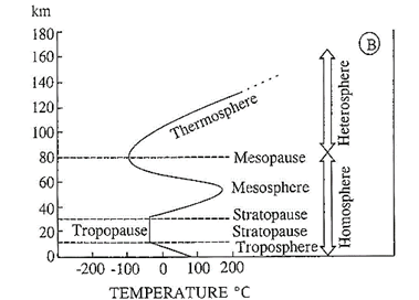
1. Homosphere
This extends up to the height of 90 kms and is characterized by uniformity in chemical composition. It consists of three thermal layers - troposphere, stratosphere and mesosphere.
[a] Troposphere
Lowest layer of the atmosphere.
[b] Stratosphere
[c] Mesosphere
2. Heterosphere
Proportions of gases are not constant in this layer.
[a] Thermosphere
It lies 80 kms above the mesosphere. In this layer the temperature increases rapidly with increase in height. The gases become very light due to extremely low density. Further it divided into two layers:
(i) Ionosphere spread between 80 km to 400 km above the surface of the earth. There are number of ionic layers in the sphere, e.g. D layer, E layer, F layer and G layer.
- D layer disappears with sunset as it is associated with solar radiation.
- E layer is known as Kennelly-Heaviside which is confined to the height between 99 km - 130 kms.
- It reflects the medium and high frequency radio waves.
- \[{{F}_{2}}\] layer is called as appleton layer, lying between 150km-380km.
- \[{{F}_{1}}\]and \[{{F}_{2}}\] area the two sub layers of \[{{E}_{2}}\] layer combinedly known as Appleton Layer.
- G layer is beyond 400 kms.
(ii) Exosphere lies extend to beyond 400 kms above the surface of the earth. Density of air is very less here because of no gravitational force and the atmosphere resembles as nebula because it is highly rarefied.
INSOLATION
Distribution of Insolation
Factors affecting the Distribution of Insolation
The non-uniformity in the amount of insolation received on the earth's surface is mostly due to following factors:
(i) Angle of incidence of the sun's rays depends on the latitude of a place. Higher the latitude less is the angle it makes with the surface of the earth causing slanting rays. The area covered by slanting rays is larger than vertical rays. The energy is distributed over a larger area. The net energy received per unit area decreases. Also slanted rays pass through a greater depth of the atmosphere resulting in more absorption, scattering and diffusion.
(ii) Length of the day : During summer, days are longer than nights. The situation is reversed with winter. Longer the day, greater will be the insolation received.
(iii) Distance between the earth and the sun: The distance between the earth and the sun is not uniform throughout the year. It is nearest to the sun (147 million km) on 3rd January and farthest (152 million km) on 4th July. It is mainly to the orbit of the earth which is elliptical in shape. When the earth is nearest to the sun it is called as perihelion and when farthest is called as aphelion.
(iv) Sunspots: Sunspots created on the outer surface due to periodic disturbance and explosions. The number of sunspots varies from year to year. Its cycle is completed in every 11 years. The energy radiated from the sun increases. When the number of sunspots increases and therefore the amount of insolation received by the earth surface is also increases.
Factors responsible for heating the atmosphere
Radiation
The process of heat transfer in the form of emitted electromagnetic waves is known as thermal radiation. The process of radiation of heat energy back from ground is known as ground radiation.
When part of ground radiation is radiated back to earth after getting absorbed by earth's atmosphere is known as counter- radiation.
(i) Wien's displacement law: According to this law wave length of the radiation is inversely proportional to the absolute temperature of the emitting body.
(ii) Stefan-Boltzman law: This law states that flow or influx, of radiation is proportional to the fourth power of the absolute temperature of radiating body.
(i) The first spectrum includes, gama rays, hard x-rays, soft x-rays and ultra violet rays. Measured in angstrom (10~8 cm) and have short wave lengths.
(ii) The second spectrum consists of visible rays. It is measured in micron and ranges between 0.4 to 0.07 micron.
(iii)The third spectrum of electromagnetic waves covers infrared spectrum. It ranges between 0.7 to 300 microns.
(iv) The fourth spectrum consists of long waves which include micro-waves, radar waves and radio waves. These waves are measured in cm and m.
Convection
The transfer of heat energy due to the movement of a mass or substance from one place to another mostly vertical is known as convection.
Conduction
The transfer of heat through molecules of an object is known as conduction. Which can be accomplished via two ways:
Advection
Advection is the lateral or horizontal transport of heat from one place to another. It generally takes place in the ocean in the form of ocean currents.
Heat Budget
Regional Distribution of Temperature
The three major heat zones based on the distance from the equal on the earth are temperate zone, the Torrid Zone and the Frigid Zone.
Torrid Zone (Tropical Zone)
This is the hottest zone of the earth. The region that lies from the Tropic of Cancer \[({{23.5}^{0}}N)\], across equator \[({{0}^{0}})\]to the Tropical of Capricorn \[({{23.5}^{0}}S)\] is considered as the torrid zone (Tropical Zone) Zone). The sun's rays directly fall at least once a year in this region.
Frigid Zone
This is the coldest zone on the earth. This region lies to the north of Arctic circle \[({{23.5}^{0}}N)\] and to the south of the Antarctic circle \[({{23.5}^{0}}S)\] and is permanently frozen. There is no sunlight for most of the months in a year in this zone.
Temperate Zone

Importance of the Heat Zones
This division of the Earth into different heat zones helps in understanding the climate changes and to study weather conditions acners the world.
ATMOSPHERIC PRESSURE
A column of air exerts weight in terms of pressure on the surface of the earth. The weight of the column of air at a given place and time is called atmospheric pressure. Air pressure is maximum at sea level. Pressure exerted by air at a particular point is determined by temperature and density.
There is inverse relation between temperature and pressure.
Air pressure is measured as a force per unit area. The unit of measuring air pressure is milibar or mb measured by an instrument called barometer.
The distribution of atmospheric pressure is shown on a map by isobars. An isobar is an imaginary line drawn through points of equal atmospheric pressure at the sea level. The spacing of isobars expresses the rate and direction of pressure change and is called pressure gradients.
Major Pressure Belts
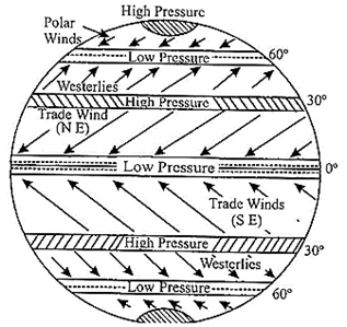
The planetary System of Pressure and Winds at the Equinoxes
Shifting of Pressure Belts
During late June, sun is overhead at the tropic of cancer. The doldrum (low pressure belt) moves northward from the equator along with other belts shifting in the northern hemisphere. In late December, when the sun is overhead at the tropic of Capricorn, the belts move southwards in a similar.
WIND
Air in motion called wind, can move in any direction. Wind is caused by spatial differences in atmospheric pressure and flows from areas of high pressure to those of low pressure. These differences are caused by uneven absorption of solar radiation at the earth's surface. Wind speed is greater during daytime when the greatest spatial extremes in atmospheric temperature and pressure exist. Wind direction is measured as the direction from where a wind comes from.
Coriolis Force
Rotation of Earth creates Coriolis force. The consequence of Coriolis force is that the moving air get deflected from their original path. Instead of wind blowing directly from high to low pressure, rotation of the earth causes wind to deflect. In the northern hemisphere, wind is deflected towards their right, while in the southern hemisphere it is deflected towards their left. This is also known as the Parrel's law. Magnitude of the Coriolis force varies with the velocity and the latitude of the object. Coriolis force is absent along equator but its strength progressively increases towards the poles.
Geostrophic Wind
Air under the influence of both the pressure gradient and
Coriolis force moves parallel to isobars in conditions where friction is low (1000 meters above the surface of the earth) and isobars are straight. Such winds are called geostrophic winds.
Gradient Wind
Wind above the earth's surface do not travel in straight lines. The winds blow along the curved isobars of a high (anticyclone) or low (cyclone) pressure center. A wind that blows around curved isobars above the level of friction is called a gradient wind.
Types of Winds
(1) Planetary winds or permanent winds
(i) Trade wind
(ii) Westerlies
(iii) Polar wind
(2) Periodic winds
(i) Seasonal wind
(ii) Local wind
(iii) Land and sea breeze
(3) Local winds
|
Local Winds |
||
|
Nature |
Nature |
Region |
|
Fohn |
Warm |
Alps |
|
Chinook (snow eater) |
Warm |
Rockies |
|
Kalbaisakhi |
Warm |
North India |
|
Berg |
Warm |
S. Africa |
|
Zonda |
Warm |
Andes |
|
Loo |
Warm |
Indian subcontinent |
|
Santa Ana |
Warm |
Coastal Southern California |
|
Southerly |
Cold |
New South Wales Burster |
|
Khamsin |
Warm |
Egypt |
|
Harmattan (Doctor) |
Warm |
Guinea Coast |
|
Mistral |
Cold |
S.E. France |
|
Samun |
Warm |
Iran |
|
Purga |
Cold |
Russia |
|
Levanter |
Cold |
France |
|
Pampero |
Cold |
S. America |
|
Norwester |
Warm, dry |
New Zealand |
|
Harmattan |
Warm, dry |
Eastern part of sahara |
Planetary winds or permanent winds blow from high pressure region to low pressure region in a fixed direction throughout the year. They are a major part of general global circulation of air. They occur due to temperature and pressure variance existing throughout the world.
They are of following types:
(i) Trade winds or easterly winds
(ii) Westerlies
(iii) Polar winds
(i) Trade Winds or Easterly Winds
Blowing from the subtropical highs or horse latitudes (between \[30{}^\circ N\] and \[30{}^\circ S\]) towards the equatorial low pressure are the trade winds or easterly winds.
(ii) Westerlies Winds
The winds that move polwards in the middle latitudes between \[35{}^\circ \] and \[65{}^\circ \] latitude, blowing from high pressure area in the latitudes towards the poles are called as Westerlies wind.
(iii) Polar Wind
Winds blowing in the arctic and the Antarctic latitudes polar winds. They blow from polar high pressure towards sub-polar low pressure belt. In the northern hemisphere they blow from north-east, and are called the north-east, and are called polar winds. In the southern hemisphere, they blow from south-east and are called south-east polar winds. As these winds blow from ice-capped landmass, which are cold.
Periodic winds changes its direction with the change seasons.
(i) Seasonal Winds
- Specific heat differences between land and water.
- Greater evaporation over water surfaces.
- Subsurface mixing in ocean basins, which redistributes heat energy to a deeper layer.
During summer the monsoon winds blow from sea towards in land area while during winter from in land area towards the seas.
(ii) Local winds: Such winds blow in comparatively small area and have special characteristics. They are generated by purely local factors (local temperature differences) and their zone of influence is quite limited. They play an important role in the weather of a particular locality.
(iii) Land and Sea Breezes: Generally, the land and seat breezes are prevalent in narrow strips along the coast or a lake. Sometimes local conditions may set air in continuous motion. Even in calm days in summer, heated air rising from land surface may cause strong breezes to move in from over the cooler sea. During night, land cools more rapidly than the sea, cool air may move seawards as land breeze, usually a gentle flow. In some countries, if the hot desert borders with the sea, strong winds may develop. Sea breeze will be felt in miles inland.
Jet Streams: These are strong, rapid and narrow air currents circumpolar westerlies blowing in upper atmosphere or into troposphere.
The minimum velocity is 108 km/hr and the average summer velocity is 130 km/hr and average winter velocity is 65 km/hr. The maximum velocity is 480 km/hr.
AIR MASS, FRONTS, CYCLONE AND ANTI-CYCLONE
Air Mass
An air mass is defined as a large part of atmosphere, having similar physical properties (especially temperature and humidity) spreading over hundreds of kilometers.
The notable centre for the development is anticyclone area which is characterised by high pressure and low pressure regions.
Classification of Air mass
Generally the air mass is classified into 4 types:
(1) Polar Air mass (P) - It originates in polar region between \[{{60}^{0}}\]N and S. Polar air mass is cold.
(2) Tropical Air mass (T) - It originates between\[{{60}^{0}}\]N and S upto equator. Tropical air mass is warm.
(3) Continental Air mass (C) - It originates over continents (land mass) and is dry in nature.
(4) Marine Air mass (M) - It originates over the oceans and in moist in nature.
These four air masses are combined with one other to form four principal air masses such as:
(1) Continental polar mass air (CP) - Cold, air and stable.
(2) Maritime polar mass air (MP) - Cold, air and unstable.
(3) Continental Tropical air mass air (CT) - hot, dry, stable (at height) and at surface Instable.
(4) Maritime Tropical air mass air (MT) - warm, moist and unstable.
Front
It is the transition zone between two air masses (warm and cold) with different properties (temperature, humidity, density, pressure and wind direction). An extensive transitional zone between two converging air masses is called as frontal zone on frontal surface. The process associated with the creation of new fronts or the regeneration decaying fronts is called frontogenesis. The process of destruction or dying of fronts is called frontolysis.
Types of Fronts
Fronts are of four principal types on the basis of their different characteristic features such as warm front, cold front, occluded front and Stationary front.
(1) Warm front
In other wards when the warm air mass moves upwards over the cold air mass is termed as front. It has gentle sloping frontal surface along with warm and light air. As they are warm and light they rise up slowly over cold and dense air. This warm air is cooled adiabatically. It saturated and gets condensed resulting in precipitation over a larger area for several hours. The precipitation varies from moderate to gentle. It is associated with Ci, Cs, As, Ns, St and fog.
(2) Cold front
It can be defined as the boundary between warm and cool air masses wherein cold air displaces warm air. It has a steep edge and move aggressively towards the warm air territory. As they remain denser at the ground, forcing the warm air to rise. The cold air mass is associated with bad weather-thick clouds, which further heavy downpour with thunderstorms and lightning. At times it results in snowfall and hailstorms. Cloud, associated with this type of front is Ci, Cs and Cb.
(3) Occluded front
When the cold front completely overtakes warm front, displacing the warm air by cold air from the ground system.
(4) Stationary front
It is the stage when the two contrasting air masses become parallel to each other and there is no ascenstet of air.
Cyclones
Cyclone in centre of low pressure surrounded by elliptical arrangement isobars. The pressure increases outward and the air move inward as the centre has low pressure. In the northern hemisphere it has anticlockwise movement and clockwise in the southern hemisphere.
It can be circular, elliptical or 'V shape.
It is of two types
(1) Extra tropical/Temperate cyclone
It is a simple depression or atmospheric disturbance having low pressure in the centre and pressure increases outward. It is found in the middle latitude \[({{35}^{0}}-{{65}^{0}})\]in both opposing air masses (warm, moist and light tropical air mass, front is created where these two air masses converge and lead to the development of temperate cyclone. The size of cyclones varies from 150 km to 3000 km. On an average vertical extent is 10-12 km. Its average summers velocity is 32 km per hours for winter it is 48 km per hour.
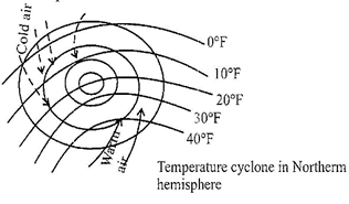
(1) Life Cycle of Cyclone
The period of cyclone from its inception (cyclogenesis) to its termination (eyclolysis) is called as life cycle of cyclone. There are six stages in a life cyclone of a cyclone:
(2) Tropical Cyclone
The development of the cyclone over the tropical region lying between tropic of cancer to Capricorn are called as Tropical Cyclones. Generally the tropical cyclones are formed along the zone of confluence of south-east and north-east trade winds. The confluence zone of these two winds is also known as the Inter Tropical Convergence Zone (ITCZ).
Types of Tropical Cyclone
Tropical cyclone are divided into 4 major types:
(1) Tropical disturbance
(2) Tropical depression
(3) Tropical storms
(4) Hurricane or typhoon
It is associated with easterly trade winds. The easterly wave develops between 5° to 20° N latitude in the western part of the oceans. It is associated with large amount of cumulus or cumulonimbus cloud. These clouds bring heavy to moderate rainfall.
This region is the centre of low pressure and characterized by closed isobars, which are small in size. The wind velocity at the centre is 40-50 km/hr. It is usually influenced by summer weather of India and Australia. Sometimes, it becomes strong and give heavy rainfall, further resulting in floods.
Tropical storm is related with low pressure centre, closed isobars which rushes towards the centre with the velocity ranging between 40 to 120 km/hr. Generally, it developes over Caribbean sea, near Philippines and Bay of Bengal causing devastation of lives and properties in the coastal regions.
It is a form of massive tropical cyclone surrounded by several closed isobars. It moves with an average speed of 120 km/ hr. Hurricane has more symmetrical and circular isobars.
The pressure increases sharply from centre towards the outermargin, resulting in pressure gradient. Heavy downpour occurs, which is often uniformly distributed over a larger area as compared to other types of tropical cyclones.
|
Tropical Cyclones are known by different names: Hurricanes - Carbbean and Pacific coast of Mexico. Typhoons - Sea of China and Japan Cyclones - India / Australia Willy-Willies - North Australia Tornado - South and Eastern USA. Bagguio - Philippines |
Comparison between Temperature and Tropical cyclones.
|
Tropical Cyclone |
Extra-tropical cyclone |
|
The tropical cyclone have a thermal origin, exclusively over the tropical seas. |
Formed in middle or high latitudes, due to the development of front (\[{{35}^{0}}-{{65}^{0}}N\]and S) |
|
The size of the tropical cyclone is 1/3 of temperate cyclone |
It is much extensive size. |
|
Strongest winds of tropical cyclones take place at surface. |
Strongest winds of mid-latitude cyclones are higher up in atmosphere. |
|
It is associated with single eye |
There is more than one place where wind and rain is active. |
|
Wind velocity is very high |
It is low in comparison to tropical cyclone. |
|
Its relation with upper level air is not clear |
It has a distinct relation with upper level of air. |
Anticyclones
The air mass in which the pressure is high at the centre but decreases outwards is anti-cyclone. Winds move in a clockwise out-spiral in the northern hemisphre but in an anticlockwise out-spiral in the southern hemisphere.
HUMIDITY
It is the amount of water vapour present in the air at a particular period of time and place. Humidity of a place can be expressed in three ways:
|
Specific Humidity Another way to express humidity as the mass of water vapour per unit weight of air or the proportion of the mass of water vapour to the total mass of air is called the specific humidity. Specific humidity is not affected by changes in pressure or temperature. |
|
Relative Humidity This is a ratio expressed between actual quantity of water vapour present in the air at a given temperature absolute humidity and the maximum quantity of water vapour that the atmosphere can hold at that temperature. Relative humidity determines the amount and rate of evaporation. |

CLOUDS
Clouds are mass of very fine water droplets, ice particles or mixture suspended in the atmosphere. They are formed by the adiabatic cooling of air when it is below its dew point. Cooling process is created by upward movement of light and warm moist air which reduces pressure, expands and reaches its dew point. There is further cooling below dew point causing condensation. Adiabatic process involves change in temperature of an ascending or descending air. The air which ascends (due to expansion of volume) results in cooling of air, whereas the air which descends results in warming a air at the rate of \[{{10}^{0}}\]per 1000 meters. This rate of shade change is called as adiabatic lapse rate. \[{{10}^{0}}\] per 1000 meters change is only before dew point (condensation level) and after dew point is achieved the rate of change in \[{{5}^{0}}\]C per 1000 m.
Types of Cloud
Usually clouds are classified in terms of their vertical arrangement in the atmosphere of high, middle and low clouds.
PRECIPITATION
It is defined as water in the form of liquid and solid falls on earth that falls under the gravity is called as precipitation. This could be in the form of rain, snow or hail etc. Its form depend on the temperature at which water vapour condenses.
Forms of Precipitation
The precipitation has several forms like droplets of water, ice flakes and solid balls or hails etc.
Hail
It is a form of solid precipitation consisting of large pellets or spheres of ice balls with the diameter varing between 5m to 50 mm. The falling of hail on the ground surface is called hailstorm. It is destructive as it destroys agricultural crops and claim human and animal lives.
Snowfall
It is the fall of large snowflakes from clouds on the ground surface. The dew point should be below freezing point for receiving snowfall. It is a result of sublimation.
Sleet
It is a mixture of snow and rain. It is a small pellets formed by freezing of raindrops or melting snowflakes.
Rainfall
It is the most common form of precipitation. It is a process wherein mass of moist air ascends, saturates and condenses.
A diabatic cooling takes place when the air rises and the relative humidity becomes 100 per cent. The condensation of water vapour takes place where large hygroscopic nuclei (salt and dust) is formed. Such droplets are called as cloud dropletsshade. Rainfall occurs when cloud droplets change to raindrops which involves two processes:
Types of Rainfall
Rainfall can be classified into three types:
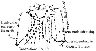
(i) The supply of moisture through evaporation should be abundant so that its relative humidity becomes high.
(ii) There should be intense heating through insolation process.
The process of convectional rainfall involves intense heating ground surface though solar radiation. As the warm air rises, the vacant shape is filled by surrounding air which too up when come in contact with already warm air. Ascending warm and moist air cools according to dry adiabatic lapse rate (\[{{10}^{0}}\]C per 1000 metres) increasing the relative humidity. The moist air becomes saturated soon (relative humid becomes 100 percent) and futher rising of saturated air causes condensation and cloud formation cumulo-nimbus clouds. The air further rises and cools with moist adiabatic lapse rate (\[{{5}^{0}}\]C per 1000 metre). When the air reaches the temperature of its surrounding cumulo-nimbus cloud is formed and there instantaneous heavy rainfall.
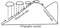
When the warm and moist air rises and is obstructed by any hill or mountain, it starts ascending along the slope of the hill or mountain and get saturated after reaching a height. As a result condenses around hygroscopic nuclei. The presence of hill or mountain triggers the process of ascending of moist air, becoming cool and unstable. The slope of the mountain facing the wind is called as windward side and the other side of that mountain is known as Leeward side. Windward side receives maximum rain and leeward side receives no or little rain. The leeward side is also known as rain shadow region. This type of rainfall is called as orographic rainfall.
When the air currents converge and rise, the convergence rainfall occurs. In tropical regions, the lifting of air is more or less vertical due to comparable temperatures of opposing air currents and usually accompanied by convention. When two large mass of air currents having unequal densities and temperature came into contact, the rising warm moist air mass reaches above the colder one. The rising warm moist air condenses to form clouds and then cause heavy rainfall. Such rainfall associated with thunder and lightning is also called as the frontal rainfall.
Distribution of precipitation
There is no uniformity of precipitation all over the world. The average annual precipitation for the world is 97.5 centimeters. The land area receives lesser amount of rainfall as compared to oceans while the different places on earth's surface receive different amount of annual rainfall and also in different seasons. On the basis of global pressure, wind bells, distribution of land and water bodies and nature of relief feature on earth, the distribution of precipitation can be explained:
(i) Equatorial regions: Amazon and Congo Basins, Malaysia, Indonesia and New Guinea.
(ii) Tropical Monsoon regions: Parts of India, South- east Asia and South China.
(iii) Mid-latitude West Margin regions: Coastal regions of British Columbia, North-west Europe, South Chile and South Island of New Zealand.
(i) Eastern margins of continents in the trade-wind belt e.g. eastern margin of China, U.S.A., Brazil, South Africa and Australia.
(i) Tropical deserts - Western margins of continents in the trade wind belt, Californian desert (USA), Atacama (South America), Kalahari (Southern Africa), Sahara, Arabian Desert and West Australian desert.
(ii) Mid-latitude desert - Interiors of large continents like Asia and North America.
(iii) Polar Regions -Arctic and Antarctic.
WORLD CLIMATIC ZONES
Forest Climate
Location
South America: Largest area is in the Amazon lowlands.
It also occurs along the coast of Guinea
Africa: Part of the Congo basin and Guinea coast Africa.
Southern Asia: Malaysia, Indonesia, New Guinea and parts of Philippines.
Climate
Vegetation
High temperature and rain throughout the year produce most luxuriant vegetation in the region which are tropical rainforest or Selvas in South America.
Location
This transitional type of climate is bounded between equatorial rainforest and semi-arid and subtropical humid climate. This lies between \[{{5}^{0}}\] to \[{{20}^{0}}\] north and south of equator.
Climate
Vegetation
Location
Arid deserts lie close to the tropic of cancer and tropic of
Capricorn in the western margins of continents, between\[{{15}^{0}}-{{30}^{0}}\] in both the hemispheres.
Climate
Vegetation
Location
These are also called mid-latitude grasslands. They are far away from any influence of the sea as they are in the heart of the continents. Examples:
Climate
Vegetation
Short grass grows everywhere. Trees are found only mountain slopes.
Location
The zone lies between \[{{30}^{0}}-{{40}^{0}}\]N and Southern latitudes on the western edge of the continents.
Vegetation
Location
Climate
Vegetation
Location
Climate
Vegetation
Location
Monsoon region includes the eastern margins of continents which lies between \[{{5}^{0}}\]to \[{{30}^{0}}\] N and Southern latitude of equator.
Climate
Vegetation
Location
This climate type is named after the coniferous forest cover found in the region.
Sweden, Finland, Northern Russia, Northern Siberia, and Sakhalin Island.
Climate
Vegetation
Location
Climate
Vegetation


You need to login to perform this action.
You will be redirected in
3 sec

