NCERT Extracts - Drainage System of India
Category : UPSC
Drainage System
- An area drained by a river and its tributaries is called a drainage basin. The boundary line separating one drainage basin from the other is known as the watershed.
- The catchments of large rivers are called river basins while those of small rivulets and rills are often referred to as watersheds.
- On the basis of the mode of origin, nature and characteristics, the Indian drainage may also be classified into the Himalayan drainage and the Peninsular drainage.
- Although it has the problem of including the Chambal, the Betwa, the Son, etc. which are much older in age and origin than other rivers that have their origin in the Himalayas, it is the most accepted basis of classification.
Important Drainage Patterns
- The drainage pattern resembling the branches of a tree is known as "dendritic" the examples: of which are the rivers of northern plain.
- When the rivers originate from a hill and flow in all directions, the drainage pattern is known as 'radial'. The rivers originating from the Amarkantak range present a good example of it.
- When the primary tributaries of rivers flow parallel to each other and secondary tributaries join them at right angles, the pattern is known as 'trellis'.
- When the rivers discharge their waters from all directions in a lake or depression, the pattern is know as 'centripetal'.
The Himalayan Drainage
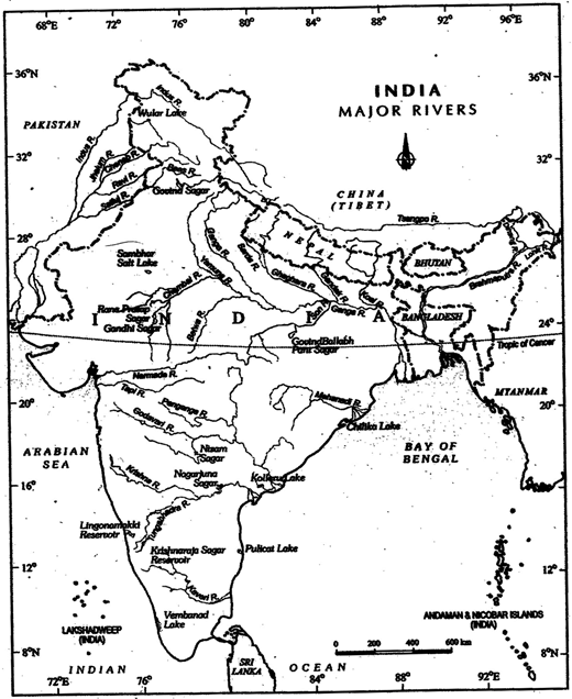
Major Rivers and Lakes
- The Himalayan drainage system has evolved through a long geological history. It mainly includes the Ganga, the Indus and the Brahmaputra river basins.
- Since these are fed both by melting of snow and precipitation, rivers of this system are perennial.
- These rivers pass through the giant gorges carved out by the erosional activity carried on simultaneously with the uplift of the Himalayas.
- Besides deep gorges, these rivers also form V-shaped valleys, rapids and waterfalls in their mountainous course.
- While entering the plains, they form depositional features like flat valleys, ox-bow lakes, flood plains, braided channels, and deltas near the river mouth.
- In the Himalayan reaches, the course of these rivers is highly tortous, but over the plains they display a strong meandering tendency and shift their courses frequently.
- River Kosi, also know as the 'sorrow of Bihar', has been notorious for frequently changing its course. The Kosi brings huge quantity of sediments from its upper reaches and deposits it in the plains. The course gets blocked, and consequently, the river changes its course.
Evolution of the Himalayan Drainage
- There are difference of opinion about the evolution of the Himalayan rivers.
- However, geologists believe that a mighty river called Shiwalik or mdo-Brahma
- traversed the entire longitudinal extent of the Himalaya from Assam to Punjab and onwards to Sind, and finally discharged into the Gulf of Sind near lower Punjab during the Miocene period some 5-24 million years ago.
- It is opined mat in due course of time Indo-Brahma river was dismembered into three main drainage systems:
- the Indus and its five tributaries in the western part;
- the Ganga and its Himalayan tributaries in the central part; and
- the stretch of the Brahmaputra in Assam and its Himalayan tributaries in the eastern part.
- The dismemberment was probably due to the Pleistocene upheaval in the western Himalayas, including the uplift of the Potwar Plateau (Delhi Ridge), which acted as the water divide between the Indus and Ganga drainage systems.
- Likewise, the downthrusting of me Malda gap area between the Rajmahal hills and the Meghalaya plateau during the mid-pleistocene period, diverted the Ganga and the Brahmaputra systems to flow towards the Bay of Bengal.
The River Systems of the Himalayan Drainage
- The Indus System
- It is one of the largest river basins of the world, a total length of 2,880 km (in India 1,114 km).
- The Indus also known as the Sindhu, is the westernmost of the Himalayan rivers in India.
- It originates from a glacier near Bokhar Chu (31°15'N in the Tibetan region at an altitude of 4,164 m in the Kailash Mountain range.
- In Tibet, it is known as 'Singi Khamban; or Lion's mouth.
- After flowing in the northwest direction between the Ladakh and Zaskar ranges, it passes through Ladakh and Baltistan. It cuts across the Ladakh range, forming a spectacular gorge near Gilgit in Jammu and Kashmir.
- It enters into Pakistan near Chillar in the Dardistan region.
- The Indus receives a number of Himalayan tributaries such as the Shyok, the Gilgit, the Zaskar, the Hunza, the Nubra, the Shigar, the Gasting and the Dras.
- It finally emerges out of the hills near Attack where it receives the Kabul river on its right bank.
- The other important tributaries joining me right bank of the Indus are the Khurram, the Tochi, the Gomal the Viboa and the Sangar.
- They all originate in the Sulaiman ranges. The river flows southward and receives 'Panjnad' a little above Mithankot.
- The Panjnad is the name given to the five rivers of Punjab, namely the Satluj, the Beas, the Ravi, the Chenab and the Jhelum.
- It finally discharges into the Arabian Sea, east of Karachi. The Indus flows in India only through the Leh district in Jammu and Kashmir.
- The Jhelum, an important tributary of the Indus, rises from a spring at Verinag situated at the foot of the Pir Panjal in the south-eastern part of the valley of Kashmir.
- It flows through Srinagar and the Wular lake before entering Pakistan through a deep narrow gorge. It joins the Chenab near Jhang in Pakistan.
- The Chenab is the largest tributary of the Indus.
- It is formed by two streams, the Chandra and the Bhaga, which join at Tandi near Keylong in Himachal Pradesh.
- Hence, it is also known as Chandrabhaga. The river flows for 1,180 km before entering into Pakistan.
- The Ravi is another important tributary of the Indus. It rises west of the Rohtang pass in the Kullu hills of Himachal Pradesh and flows through the Chamba valley of the state.
- Before entering Pakistan and joining the Chenab near Sarai Sidhu, it drains the area lying between the southeastern part of the Pir Panjal and the Dhauladhar ranges.
- The Beas is another important tributary of the Indus, originating from the Beas Kund near the Rohtang Pass at an elevation of 4,000 m above the mean sea level.
- The river flows through the Kullu valley and forms gorges at Kati and Largi in the Dhaoladhar range.
- It enters the Punjab plains where it meets the Satluj near Harike.
- The Satluj originates in the Rakas lake near Mansarovar at an altitude of 4,555 m in Tibet where it is known as Langchen Khambab.
- It flows almost parallel to the Indus for about 400 km before entering India, and comes out of a gorge at Rupar.
- It passes through the Shipki La on the Himalayan ranges and enters the Punjab plains.
- It is an antecedent river. It is a very important tributary as it feeds the canal system of the Bhakra Nangal project.
The Ganga System
- The Ganga is the most important river of India both from the point of view of its basin and cultural significance. It rises in the Gangotri glacier near Gaumukh (3,900 m) in the Uttarkashi district of Uttarakhand. Here, it is known as the Bhagirathi.
- It cuts through the Central and the Lesser Himalayas in narrow gorges.
- At Devprayag, the Bhagirathi meets the Alaknanda; hereafter, it is known as the Ganga. The Alaknanda has its source in the Satopanth glacier above Badrinath.
- The Alaknanda consists of the Dhauli and the Vishnu Ganga which meet at Joshimath or Vishnu Prayag.
- The other tributaries of Alaknanda such as the Pindar joins it at Kama Prayag while Mandakini or Kali Ganga meets it at Rudra Prayag.
- The Ganga enters the plains at Haridwar. From here, it flows first to the south, then to the south-east and east before splitting into two distributaries, namely the Bhagirathi and the Hugli.
- The river has a length of 2,525 km. It is shared by Uttarakhand (110 km) and Uttar Pradesh (1,450 km), Bihar (445 km) and West Bengal (520 km).
- The Ganga basin covers about 8.6 lakh sq.km area in India alone. The Ganga river system is the largest in India having a number of perennial and non- perennial rivers originating in the Himalayas in the north and the Peninsula in the south, respectively.
- The Son is its major right bank tributary.
- The important left bank tributaries are the Ramganga, the Gomati, the Ghaghara, the Gandak, the Kosi and the Mahananda.
- The river finally discharges itself into the Bay of Bengal near the Sagar Island.
- The Yamuna, the western most and the longest tributary of the Ganga, has its source in the Yamunotri glacier on the western slopes of Banderpunch range (6,316km).
- It joins the Ganga at Prayag (Allahabad). It is joined by the Chambal, the Sind, the Betwa and the Ken on its right bank which originates from the Peninsular plateau while the Hindan, the Rind, the Sengar, the Varuna, etc. join it on its left bank.
- Much of its water feeds the western and eastern Yamuna and the Agra canals for irrigation purposes.
- The Chambal rises near Mhow in the Malwa plateau of Madhya Pradesh and flows northwards through a gorge up wards of Kota in Rajasthan, where the Gandhisagar dam has been constructed.
- From Kota, it traverses down to Bundi, Sawai Madhopur and Dholpur, and finally joins the Yamuna.
- The Chambal is famous for its badland topography called the Chambal ravines.
- The Gandak comprises two streams, namely Kaligandak and Trishulganga.
- It rises in the Nepal Himalayas between the Dhaulagiri and Mount Everest and drains the central part of Nepal.
- It enters the Ganga plain in Champaran district of Bihar and joins the Ganga at Sonpur near Patna.
- The Ghaghara originates in the glaciers of Mapchachungo.
- After collecting the waters of its tributaries - TUa, Seti and Beri, it comes out of the mountain, cutting a deep gorge at Shishapani.
- The river Sarda (Kali or Kali Ganga) joins it in me plain before it finally meets the Ganga at Chhapra.
- The Kosi is an antecedent river with its source to the north of Mount Everest in Tibet, where its main stream Arun rises.
- After crossing the Central Himalayas in Nepal, it is joined by the Son Kosi from the West and the Tamur Kosi from the east.
- It forms Sapt Kosi after uniting with the river Arun.
- The Ramganga is comparatively a small river rising in the Garhwal hills near Gairsain.
- It changes its course to the southwest direction after crossing the Shiwalik and enters into the plains of Uttar Pradesh near Najibabad. Finally, it joins the Ganga near Kannauj.
- The Damodar occupies the eastern margins of the Chotanagpur Plateau where it flows through a rift valley and finally joins the Hugli. The Barakar is its main tributary.
- Once known as the 'sorrow of Bengal', the Damodar has been now tamed by the Damodar Valley corporation, a multipurpose project.
- The Sarda or Saryu river rises in the Milam glacier in the Nepal Himalayas where it is known as the Goriganga. Along the mdo-Nepal border, it is called Kali or Ghauk, where it joins the Ghaghara.
- The Mahananda is another important tributary of the Ganga rising in the Dariiling hills. It joins the Ganga as its last left bank tributary in West Bengal.
- The son is a large south bank tributary of the Ganga, originating in the Amarkantak plateau. After forming a series of waterfalls at the edge of the plateau, it reaches Arrah, west of Patna, to join the Ganga.
The Brahmaputra System
- The Brahmaputra, one of the largest rivers of me world, has its origin in the Chemayungdung glacier of the Kailash range near the Mansarovar lake.
- From here, it traverses eastward longitudinally for a distance of nearly 1,200 km in a dry and flat region of southern Tibet, where it is known as the Tsangpo, which means'the purifier'.
- The Rango Tsangpo is the major right bank tributary of this river in Tibet.
- It emerges as a turbulent and dynamic river after carving out a deep gorge in the central Himalayas' near Namcha Barwa (7,755 m).
- The river emerges from the foothills under the name of Siang or Dihang.
- It enters India west of Sadiya town in Arunachal Pradesh.
- Flowing southwest, it receives its main left bank tributaries, viz., Dibang or Sikang and Lohit; thereafter, it is known as the Brahmaputra.
- The Brahmaputra receives numerous tributaries in its 750 km long journey through me Assam valley.
- Its major left bank tributaries are the Burhi Dihing and Dhansari (South) whereas the important right bank tributaries are the Subansiri, Kameng, Manas and Sankosh.
- The Subansiri which has its origin in Tibet, is an antecedent river.
- The Brahmaputra enters into Bangladesh near Dhubri and flows southward.
- In Bangladesh, the Tista joins it on its right bank from where the river is known as the Yamuna.
- It finally merges with the river Padma, which falls in the Bay of Bengal.
- The Brahmaputra is well-known for floods, channel shifting and bank erosion.
- This is due to the fact that most of its tributaries are large, and bring large quantity of sediments owing to heavy rainfall in its catchment area.
The Peninsular Drainage System
- The Peninsular drainage system is older than the Himalayan one. This is evident from the broad, largely-graded shallow valleys, and the maturity of the rivers.
- The Western Gnats running close to the western coast act as the water divide between the major Peninsular rivers, discharging their water in the Bay of Bengal and as small rivulets joining the Arabian Sea.
- Mask of the major Peninsular rivers except Narmada and Tapi flow from west to east.
- The Chambal, the Sind, the Betwa, the Ken, the Son, originating in the northern part of the Peninsula belong to the Ganga river system.
- The other major river systems of the Peninsular drainage are - the Mahanadi the Godavari, the Krishna and the Kaveri.
- Peninsular rivers are characterised by fixed course, absence of meanders and nonperennial flow of water.
- The Narmada and the Tapi which flow through the rift valley are, however, exceptions.
The Evolution of Peninsular Drainage System
- Three major geological events in the distant past have shaped the present drainage systems of Peninsular India :
- Subsidence of the western flank of the Peninsula leading to its submergence below the sea during the early tertiary period. Generally, it has disturbed the symmetrical plan of the river on either side of the original watershed.
- Upheaval of the Himalayas when the northern flank of the Peninsular block was subjected to subsidence and the consequent trough faulting. The Narmada and The Tapi flow in trough faults and fill the original cracks with their detritus materials. Hence, there is a lack of alluvial and deltaic deposits in these rivers.
- Slight tilting of the Peninsular block from northwest to the southeastern direction gave orientation to the entire drainage system towards the Bay of Bengal during the same period.
River Systems of the Peninsular Drainage
- The Mahanadi rises near Sihawa in Raipur district of Chhattisgarh and runs through Odisha to discharge its water into the Bay of Bengal.
- 53 per cent of the drainage basin of this river lies in Madhya Pradesh and Chhattisgarh; while 47 per cent lies in Odisha.
- The Godavari is the largest Peninsular river system. It is also called the Dakshin Ganga. It rises in the Nasik district of Maharashtra and discharges its water into the Bay of Bengal.
- Its tributaries run through the states of Maharashtra, Madhya Pradesh, Chhattisgarh, Odisha and Andhra Pradesh.
- It is 1,465 km long with a catchment area spreading over 3.13 lakh sq.km 49 per cent of this, lies in Maharashtra, 20 per cent in Madhya Pradesh and Chhattisgarh, and the rest in Andhra Pradesh.
- The Penganga, the Indravati, the Pranhita, and the Manjra are its principal tributaries.
- The Godavari is subjected to heavy floods in its lower reaches to the south of Polavaram, where it forms a picturesque gorge.
- It is navigable only in the deltaic stretch. The river after Rajamundri splits into several branches 'forming a large delta.
- The Krishna is the second largest eastflowing Peninsular river which rises near Mahabaleshwar in Sahyadri. Its total length is 1,401 km.
- The Koyna, the Tungbhadra and the Bhima are its major tributaries. Of the total catchment area of the Krishna, 27 per cent lies in Maharashtra, 44 per cent in Kamataka and 29 per cent in Andhra Pradesh.
- The Kaveri rises in Brahmagiri hills (1,341 m) of Kogadu district in Kamataka. Its length is 800 km and it drains an area of 81,155 sq.km.
- Since the upper catehment area receives rainfall during the southwest monsoon (summer) and the lower part during the northeast monsoon season (winter), the river carries water throughout the year with comparatively less fluctuation than the other Peninsular rivers.
- About 3 per cent of the Kaveri basin falls in Kerala, 41 per cent in Kamataka and 56 per cent in Tamil Nadu.
- Its important tributaries are the Kabini, the Bhavani and the Amravati.
- The Narmada originates on the western flank of the Amarkantak plateau at a height of about 1,057m.
- Flowing in a rift valley between the Satpura in the south and the Vindhyan range in the north, it forms a picturesque gorge in marble rocks and Dhuandhar waterfall near Jabalpur.
- After flowing a distance of about 1,312 km, it meets the Arabian sea south of Bharuch, forming broad-27km long estuary.
- Its catchment area is about 98,796 sq.km. The Sardar Sarovar Project has been constructed on this river.
- The Tapi is the other important westward flowing river. It originates from Multai in the Betel district of Madhya Pradesh.
- It is 724 km long and drains an area of 65,145 sq.km7 Nearly 79 per cent of its basin lies in Maharashtra, 15 per cent in Madhya Pradesh and the remaining 6 per cent in Gujarat.
- Luni is the largest river system of Rajasthan, west of Aravali.
- It originates near Pushkar in two branches, i.e. the Saraswati and the Sabarmati, which join with each other at Govindgarh.
- From here, the river comes out of Aravali and is known as Luni.
- It flows towards the west till Telwara and then takes a southwest direction to join the Rann of Kuchchh. The entire river system is ephemeral.
Smaller Rivers Flowing Towards the West
- The rivers flowing towards the Arabian sea have short courses. The Shetruniji is one such river which rises near Dalkahwa in Amreli district.
- The Bhadra originates near Aniali village in Rajkot district.
- The Dhadhar rises near Ghantar village m Panchmahal district. Sabarmati and Mahi are the two famous rivers of Gujarat.
- The Vaitama rises from the Trimbak hills in Nasik district at an elevation of 670 m.
|
S.No.
|
Aspects
|
Himalayan River
|
Peninsular River
|
|
1.
|
Place of origin
|
Himalayan mountain covered with glaciers
|
Peninsular plateau and central highland
|
|
2.
|
Nature of flow
|
Perennial; receive water from glacier and rainfall
|
Seasonal; dependent on monsoon rainfall
|
|
3.
|
Type of drainage
|
Antecedent and consequent leading to dendritic pattern in plains
|
Super imposed, rejuvenated resulting in trellis, radial and rectangular patterns
|
|
4.
|
Nature of river
|
Long course, flowing through the rugged mountains experiencing headward erosion and river capturing; In plains meandering and shifting of course
|
Smaller, fixed course with well-adjusted valleys
|
|
5.
|
Catchment area
|
Very large basins
|
Relatively smaller basin
|
|
6.
|
Age of the river
|
Young and youthful, active and deepening in the valleys
|
Old rivers with graded profile, and have almost reached their base levels
|
Comparison between the Himalayan and the Peninsular River
- The Kalinadi rises from Belgaum district and falls in the Karwar Bay.
- The source of Bedti river lies in Hubli Dharwar and traverses a course of 161 km.
- The Sharavati is another important river in Kamataka flowing towards the west.
- The Sharavati originates in Shimoga district of Kamataka and drains a catchment area of 2,209 sq.km.
- Goa has two important rivers which can be mentioned here. One is Mandovi and the other is Juari.
- Kerala has a narrow coastline. The longest river of Kerala, Bharathapuzha rises near Annamalai hills.
- It is also known as Ponnani. It drains an area of 5,397 sq.km.
- The Periyar is the second largest river of Kerala.
- Another river of Kerala worth mentioning is the Pamba river which falls in the Vemobanad lake after traversing a course of 177 km.
Some Important Facts
- The north Indian rivers originating from the Himalayas are perennial as they are fed by glaciers through snow melt and also receive rainfall water during rainy season.
- The rivers of South India do not originate from glaciers and their flow pattern witnesses fluctuations.
- The flow increases considerably during monsoon rains.
- Thus, me regime of the rivers of South India is controlled by rainfall which also varies from one part of the Peninsular plateau to the other.
- The discharge is the volume of water flowing in a river measured over time. It is measured either in cusecs (cubic feet per second) or cumecs (cubic metres per second).