Hydrological Cycle
- Water is an essential component of all life forms that exist over the surface of the earth.
- The creatures on the earth are lucky that it is a water planet, otherwise we all would have no existence.
- Water is a rare commodity in our solar system. There is no water on the sun or anywhere else in the solar system.
- The earth, fortunately has an abundant supply of water on its surface. Hence, our planet is called the 'Blue Planet'.
- Water is a cyclic resource. It can be used and re-used.
- Water also undergoes a cycle from the ocean to land and land to ocean.
- Next to air, water is the most important element required for the existence of life on earth.
- The hydrological cycle, is the circulation of water within the earth's hydrosphere in different forms i.e. the liquid, solid and the gaseous phases.
- About 71 per cent of the planetary water is found in the oceans.
- The remaining is held as freshwater in glaciers and icecaps, groundwater sources, lakes, soil moisture, atmosphere, streams and within life.
- Nearly 59 per cent of the water that falls on land returns to the atmosphere through evaporation from over the oceans as well as from other places.
Relief of the Ocean Floor
- The oceans are confined to the great depressions of the earth's outer layer.
- The geographers have divided the oceanic part of the earth into five oceans, namely the Pacific, the Atlantic, the Indian, Southern ocean and the Arctic.
- The various seas, bays, gulfs and other inlets are parts of these four large oceans.
- The floors of the oceans are rugged with the world's largest mountain ranges, deepest trenches and the largest plains.
- These features are formed, like those of the continents, by the factors of tectonic, volcanic and depositional processes.
Divisions of the Ocean Floors
- The ocean floors can be divided into four major divisions :
- the Continental Shelf
- the Continental Slope
- the Deep Sea Plain
- the Oceanic Deeps
- Besides, these divisions there are also major and minor relief features in the ocean floors like ridges, hills, sea mounts, guyots, trenches, canyons, etc.
Continental Shelf
- The continental shelf is the extended margin of each continent occupied by relatively shallow seas and gulfs.
- It is the shallowest part of the ocean showing an average gradient of 1° or even less.
- The shelf typically ends at a very steep slope, called the shelf break.
- The width of the continental shelves vary from one ocean to another.
- The average width of continental shelves is about 80 km.
- The shelves are almost absent or very narrow along some of the margins like the coasts of Chile, the west coast of Sumatra, etc.
- On the contrary, the Siberian shelf in the Arctic Ocean, the largest in the world, stretches to 1,500 km in width.
- The depth of the shelves also varies. It may be as shallow as 30 m in some areas while in some areas it is as deep as 600 m.
- The continental shelves are covered with variable thicknesses of sediments brought down by rivers, glaciers, wind, from the land and distributed by waves and currents.
- Massive sedimentary deposits received over a long time by the continental shelves, ; become the source of fossil fuels.
Continental Slope
- The continental slope connects the continental shelf and the ocean basins.
- It begins where the bottom of the continental shelf sharply drops off into a steep slope.
- The gradient of the slope region varies between 2-5°.
- The depth of the slope region varies between 200 and 3,000 m.
- The slope boundary indicates the end of the continents. Canyons and trenches are observed in this region.
Deep Sea Plain
- Deep sea plains are gently sloping areas of the ocean basins.
- These are the flattest and smoothest regions of the world.
- The depths vary between 3,000 and 6,000 m. These plains are covered with fine grained sediments like clay and silt.
Oceanic Deeps or Trenches
- These areas are the deepest parts of the oceans. The trenches are relatively steep sided, narrow basins.
- They are some 3-5 km deeper than the surrounding ocean floor.
- They occur at the bases of continental slopes and along island arcs and are associated with active volcanoes and strong earthquakes.
- That is why they are very significant in the study of plate movements.
- As many as 57 deeps have been explored so far; of which 32 are in the Pacific Ocean; 19 in the Atlantic Ocean and 6 in the Indian Ocean.
Minor Relief Features
- Apart from the above mentioned major relief features of the ocean floor, some minor but significant features predominate in different parts of the oceans.
Mid-Oceanic Ridges
- A mid-oceanic ridge is composed of two chains of mountains separated by a large depression.
- The mountain ranges can have peaks as high as 2,500 m and some even reach above the ocean's surface. Iceland, a part of the mid-Atlantic Ridge, is an example.
Seamount
- It is a mountain with pointed summits, rising from the seafloor that does not reach the surface of the ocean.
- Seamounts are volcanic in origin. These can be 3,000-4,500 m tall.
- The Emperor seamount, an extension of the Hawaiian Islands in the Pacific Ocean, is a good example.
Submarine Canyons
- These are deep valleys, some comparable to the Grand Canyon of the Colorado river.
- They are sometimes found cutting across the continental shelves and slopes, often extending from the mouths of large rivers.
- The Hudson Canyon is the best known submarine canyon in the world.
Guyots
- It is a flat topped seamount. They show evidences of gradual subsidence through stages to become flat topped submerged mountains.
- It is estimated that more than 10,000 seamounts and guyots exist in the Pacific Ocean alone.
Atoll
- These are low islands found in the tropical oceans consisting of coral reefs surrounding a central depression.
- It may be a part of the sea (lagoon), or sometimes form enclosing a body of fresh, brackish, or highly saline water.
Temperature of Ocean Waters
- This section deals with the spatial and vertical variations of temperature in various oceans.
- Ocean waters get heated up by the solar energy just as land.
- The process of heating and cooling of the oceanic water is slower than land.
- Factors Affecting Temperature Distribution The factors which affect the distribution of temperature of ocean water are:
- Latitude: The temperature of surface water decreases from the equator towards the poles because the amount of insolation decreases poleward.
- Unequal distribution of land and water: The oceans in the northern hemisphere receive more heat due to their contact with larger extent of land than the oceans in the southern hemisphere.
- Prevailing wind: The winds blowing from the land towards the oceans drive warm surface water away form the coast resulting in the upwelling of cold water from below. It results into the longitudinal variation in the temperature. Contrary to this, the onshore winds pile up warm water near the coast and this raises the temperature.
- Ocean currents: Warm ocean currents raise the temperature in cold areas while the cold currents decrease the temperature in warm ocean areas. Gulf stream (warm current) raises the temperature near the eastern coast of North America and the West Coast of Europe while the Labrador current (cold current) lowers the temperature near the north-east coast of North America.
- All these factors influence the temperature of the ocean currents locally.
- The enclosed seas in the low latitudes record relatively higher temperature than the open seas; whereas the enclosed seas in the high latitudes have lower temperature than the open seas.
Horizontal and Vertical Distribution of Temperature
- The temperature-depth profile for the ocean water shows how the temperature decreases with the increasing depth.
- This boundary region, from where there is a rapid decrease of temperature, is called the thennocline.
- About 90 per cent of the total volume of water is found below the thennocline in the deep ocean. In this zone, temperatures approach 0°C.
- The third layer is very cold and extends upto the deep ocean floor. In the Arctic and Antartic circles, the surface water temperatures are close to 0°C and so the temperature change with the depth is very slight.
- Here, only one layer of cold water exists, which extends from surface to deep ocean floor.
- The average temperature of surface water of the oceans is about 27°C and it gradually decreases from the equator towards the poles.
- The rate of decrease of temperature with increasing latitude is generally 0.5°C per latitude.
- The average temperature is around 22°C at 20° latitudes, 14°C at 40° latitudes and 0°C near poles.
- The oceans in the northern hemisphere record relatively higher temperature than in the southern hemisphere.
- The highest temperature is not recorded at the equator but slightly towards north of it.
- The average annual temperatures for the northern and southern hemisphere are around 19°C and 16°C respectively.
- This variation is due to the unequal distribution of land and water in the northern and southern hemispheres.
- It is a well known fact that the maximum temperature of the oceans is always at their surfaces because they directly receive the heat from the sun and the heat is transmitted to the lower sections of the oceans through the process of convection.
- It results into decrease of temperature with the increasing depth, but the rate of decrease is not uniform throughout.
- The temperature falls very rapidly up to the depth of 200 m and thereafter, the rate of decrease of temperature is slowed down.
Salinity of Ocean Waters
- All waters in nature, whether rain water or ocean water, contain dissolved mineral salts.
- Salinity is the term used to define the total content of dissolved salts in sea water.
- It is calculated as the amount of salt (in gm) dissolved in 1,000 gm (1 kg) of seawater.
- It is usually expressed as parts per thousand \[({o}/{oo}\;)\]or ppt. Salinity is an important property of sea water.
- Salinity of \[24.7{o}/{oo}\;\] has been considered as the upper limit to demarcate 'brackish water'.
- Factors affecting ocean salinity are mentioned below :
- The salinity of water in the surface layer of oceans depend mainly on evaporation and precipitation.
- Surface salinity is greatly influenced in coastal regions by the fresh water flow from rivers, and in polar regions by the processes of freezing and thawing of ice.
- Wind, also influences salinity of an area by transferring water to other areas.
- The ocean currents contribute to the salinity variations. Salinity, temperature and density of water are interrelated. Hence, any change in the temperature or density influences the salinity of water in an area.
- Highest salinity in water bodies Lake Van in Turkey \[(330{o}/{oo}\;),\] Dead Sea \[(238{o}/{oo}\;),\] Great Salt Lake \[(220{o}/{oo}\;).\]
Horizontal Distribution of Salinity
- The salinity for normal open ocean ranges between \[33{o}/{oo}\;\] and \[37{o}/{oo}\;.\]
- In the land locked Red Sea, it is as high as \[41{o}/{oo}\;,\]while in the estuaries and the Arctic, the salinity fluctuates from \[0-35{o}/{oo}\;,\] seasonally.
- In hot and dry regions, where evaporation is high, the salinity sometimes reaches to \[70{o}/{oo}\;.\]
- salinity variation in the Pacific Ocean is mainly due to its shape and larger areal extent.
- Salinity decreases from \[35{o}/{oo}\;-31{o}/{oo}\;\] on the western parts of the northern hemisphere because of the influx of melted water from the Arctic region. In the same way, after 15°-20° south, it decreases to \[33{o}/{oo}\;.\]
- The average salinity of the Atlantic Ocean is around \[36{o}/{oo}\;.\] The highest salinity is recorded between 15° and 20° latitudes.
- Maximum salinity \[(37{o}/{oo}\;)\]is observed between 20°N and 30°N and 20°W- 60°W. It gradually decreases towards the north.
- The North Sea, in spite of its location in higher latitudes, records higher salinity due to more saline water brought by the North Atlantic Drift.
- Baltic Sea records low salinity due to influx of river waters in large quantity.
- The Mediterranean Sea records higher salinity due to high evaporation.
- Salinity is, however, very low in Black Sea due to enormous fresh water influx by rivers. The average salinity of the Indian Ocean is \[35{o}/{oo}\;.\]
- The low salinity trend is observed in the Bay of Bengal due to influx of river water.
- On the contrary, the Arabian Sea shows higher salinity due to high evaporation and low influx of fresh water.
Vertical Distribution of Salinity
- Salinity changes with depth, but the way it changes depends upon the location of the sea.
- Salinity at the surface increases by the loss of water to ice or evaporation, or decreased by the input of fresh waters, such as from the rivers.
- Salinity at depth is very much fixed, because there is no way that water is 'lost', or the salt is 'added.'
- There is a marked difference in the salinity between the surface zones and the deep zones of the oceans. The lower salinity water rests above the higher salinity dense water.
- Salinity, generally, increases with depth and there is a distinct zone called the halocline, where salinity increases sharply.
- Other factors being constant, increasing salinity of seawater causes its density to increase.
- High salinity seawater, generally, sinks below the lower salinity water. This leads to stratification by salinity.
Movements of Ocean Water
- The ocean water is dynamic.
- Its physical characteristics like temperature, salinity, density and the external forces like of. the sun, moon and the winds influence the movement of ocean water.
- The horizontal and vertical motions are common in ocean water bodies. The horizontal motion refers to the ocean currents and waves. The vertical motion refers to tides.
- Ocean currents are the continuous flow of huge amount of water in a definite direction while the waves are the horizontal motion of water.
- Water moves ahead from one place to another through ocean currents while the water in the waves does not move, but the wave trains move ahead.
- The vertical motion refers to the rise and fall of water in the oceans and seas.
- Due to attraction of the sun and the moon, the ocean water is raised up and falls down twice a day.
- The upwelling of cold water from subsurface and the sinking of surface water are also forms of vertical motion of ocean water.
Waves
- Waves are actually the energy, not the water as such, which moves across the ocean surface.
- Water particles only travel in a small circle as a wave passes.
- Wind provides energy to the waves.
- Wind causes waves to travel in the ocean and the energy is released on shorelines.
- The motion of the surface water seldom affects the stagnant deep bottom water of the oceans.
- As a wave approaches the beach, it slows down.
- This is due to the friction occurring between the dynamic water and the sea floor.
- And, when the depth of water is less than half the wavelength of the wave, the wave breaks.
- The largest waves are found in the open oceans.
- Waves continue to grow larger as they move and absorb energy from the wind.
- Most of the waves are caused by the wind driving against water.
- When a breeze of two knots or less blows over calm water, small ripples form and grow as the wind speed increases until white caps appear in the breaking waves.
- Waves may travel thousands of km before rolling ashore, breaking and dissolving as surf.
Tides
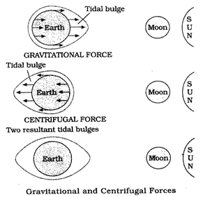
Figure : Relation between gravitational forces and tides
- The periodical rise and fall of the sea level, once or twice a day, mainly due to the attraction of the sun and the moon, is called a tide.
- Movement of water caused by meteorological effects (winds and atmospheric pressure changes) are called surges. Surges are not regular like tides.
- The study of tides is very complex, spatially and temporally, as it has great variations in frequency, magnitude and height.
- The moon's gravitational pull to a great extent and to a lesser extent the sun's gravitational pull, are the major causes for the occurrence of tides.
- Another factor is centrifugal force, which is the force that acts to counter balance the gravity. Q Together, the gravitational pull and the centrifugal force are responsible for creating the two major tidal bulges on the earth.
- On the side of the earth facing the moon, a tidal bulge occurs while on the opposite side though the gravitational attraction of the moon is less as it is farther away, the centrifugal force causes tidal bulge on the other side.
- The 'tide-generating' force is the difference between these two forces; i.e. the gravitational attraction of the moon and the centrifugal force.
- On the surface of the earth, nearest the moon, pull or the attractive force of the moon is greater than the centrifugal force, and so there is a net force causing a bulge towards the moon.
- On the opposite side of the earth, the attractive force is less, as it is farther away from the moon, the centrifugal force is dominant.
- Hence, there is a net force away from the moon. It creates the second bulge away from the moon.
- On the surface of the earth, the horizontal tide generating forces are more important than the vertical forces in generating the tidal bulges.
- The tidal bulges on wide continental shelves, have greater height.
- When tidal bulges hit the mid-oceanic islands they become low.
- The shape of bays and estuaries along a coastline can also magnify the intensity of tides.
- Funnel-shaped bays greatly change tidal magnitudes.
- When the tide is channelled between islands or into bays and estuaries they are called tidal currents.
- The highest tides in the world occur in the Bay of Fundy in Nova Scotia, Canada. The tidal bulge is 15-16 m.
- Because there are two high tides and two low tides every day (roughly a 24 hour period); then a tide must come in within about a six hour period.
Types of Tides
Spring tides:
- The position of both the sun and the moon in relation to the earth has direct bearing on tide height.
- When the sun, the moon and the earth are in a straight line, the height of the tide will be higher,
- These are called spring tides and they occur twice a month, one on full moon period and another during new moon period.
Neap tides :
- Normally, there is a seven day interval between the spring tides and neap tides.
- At this time the sun and moon are at right angles to each other and the forces of the sun and moon tend to counteract one another.
- The Moon's attraction, though more than twice as strong as the sun's, is diminished by the counteracting force of the sun's gravitational pull.
- Once in a month, when the moon's orbit is closest to the earth (perigee), unusually high and low tides occur.
- During this time the tidal range is greater than normal.
- Two weeks later, when the moon is farthest from earth (apogee), the moon's gravitational force is limited and the tidal ranges are less than their average heights.
- When the earth is closest to the sun (perihelion), around 3 January each year, tidal ranges are also much greater, with unusually high and unusually low tides.
- When the earth is farthest from the sun (aphelion), around 4 July each year, tidal ranges are much less than average.
- The time between the high tide and low tide, when the water level is falling, is called the ebb.
- The time between the low tide and high tide, when the tide is rising, is called the flow or flood.
Importance of Tides
- Since tides are caused by the earth-moon-sun positions which are known accurately, the tides can be predicted well in advance.
- This helps the navigators and fishermen plan their activities. Tidal flows are of great importance in navigation.
- Tidal heights are very important, especially harbours near rivers and within estuaries having shallow 'bars' at the entrance, which prevent ships and boats from entering into the harbour.
- Tides are also helpful in desilting the sediments and in removing polluted water from river estuaries.
- Tides are used to generate electrical power (in Canada, France, Russia, and China). A 3 MW tidal power project at Durgaduani in Sunderbans of West Bengal is under way.
Ocean Currents
- Ocean currents are like river flow in oceans.
- They represent a regular volume of water in a definite path and direction.
- Ocean currents are influenced by two types of forces namely :
- primary forces that initiate the movement of water;
- secondary forces that influence the currents to flow.
- The primary forces that influence the currents are :
- heating by solar energy;
- wind;
- gravity;
- coriolis force.
- Heating by solar energy causes the water to expand. That is why, near the equator the ocean water is about 8 cm higher in level than in the middle latitudes.
- This causes a very slight gradient and water tends to flow down the slope.
- Wind blowing on the surface of the ocean pushes the water to move.
- Friction between the wind and the water surface affects the movement of the water body in its course.
- Gravity tends to pull the water down the pile and create gradient variation.
- The Coriolis force intervenes and causes the water to move to the right in the northern hemisphere and to the left in the southern hemisphere.
Ocean Currents
- These large accumulations of water and the flow around them are called Gyres. These produce large circular currents in all the ocean basins.
- Characteristics of Ocean Currents
- Currents are referred to by their "drift".
- Usually, the currents are strongest near the surface and may attain speeds over five knots.
- At depths, currents are generally slow with speeds less than 0.5 knots.
- We refer to the speed of a current as its "drift." Drift is measured in terms of knots.
- The strength of a current refers to the speed of the current.
- A fast current is considered strong. A current is usually strongest at the surface and decreases in strength (speed) with depth. Most currents have speeds less than or equal to 5 knots.
- Differences in water density affect vertical mobility of ocean currents.
- Water with high salinity is denser than water with low salinity and in the same way cold water is denser than warm water.
- Denser water tends to sink, while relatively lighter water tends to rise.
- Cold-water ocean currents occur when the cold water at the poles sinks and slowly moves towards the equator.
- Warm-water currents travel out from the equator along the surface, flowing towards the poles to replace the sinking cold water.
Types of Ocean Currents
- The ocean currents may be classified based on their depth as surface currents and deep water currents :
- surface currents constitute about 10 per cent of all the water in the ocean, these waters are the upper 400 m of the ocean;
- deep water currents make up the other 90 per cent of the ocean water.
- These waters move around the ocean basins due to variations in the density and gravity.
- Deep waters sink into the deep ocean basins at high latitudes, where the temperatures are cold enough to cause the density to increase.
- Ocean currents can also be classified based on temperature : as cold currents and warm currents :
- cold currents bring cold water into warm water areas. These currents are usually found on the west coast of the continents in the low and middle latitudes (true in both hemispheres) and on the east coast in the higher latitudes in the Northern Hemisphere;
- warm currents bring warm water into cold water areas and are usually observed on the east coast of continents in the low and middle latitudes (true in both hemispheres). In the northern hemisphere they are found on the west coasts of continents in high latitudes.
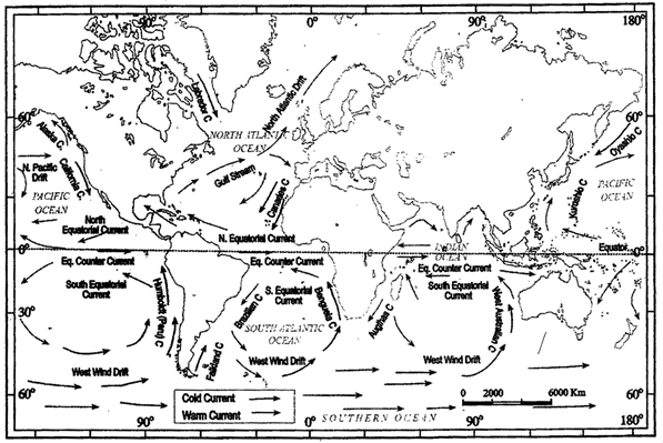
Major Ocean Currents
- Major ocean currents are greatly influenced by the stresses exerted by the prevailing winds and coriolis force.
- The oceanic circulation pattern roughly corresponds to the earth's atmospheric circulation pattern.
- The air circulation over the oceans in the middle latitudes is mainly anticyclonic (more pronounced in the southern hemisphere than in the northern hemisphere).
- The oceanic circulation pattern also corresponds with the same.
- At higher latitudes, where the wind flow is mostly cyclonic, the oceanic circulation follows this pattern.
- In regions of pronounced monsoonal flow, the monsoon winds influence the current movements.
- Due to the coriolis force, the warm currents from low latitudes tend to move to the right in the northern hemisphere and to their left in the southern hemisphere.
- The oceanic circulation transports heat from one latitude belt to another in a manner similar to the heat transported by the general circulation of the atmosphere.
- The cold waters of the Arctic and Antarctic circles move towards warmer water in tropical and equatorial regions, while the warm waters of the lower latitudes move polewards
Effects of Ocean Currents
Ocean currents have a nurftber of direct and indirect influences on human activities.
- West coasts of the continents in tropical and subtropical latitudes (except close to the equator) are bordered by cool waters.
- Their average temperatures are relatively low with a narrow diurnal and annual ranges.
- There is fog, but generally the areas are arid. West coasts of the continents in the middle and higher latitudes are bordered by warm waters which cause a distinct marine climate.
- They are characterised by cool summers and relatively mild winters with a narrow annual range of temperatures.
- Warm currents flow parallel to the east coasts of the continents in tropical and subtropical latitudes. This results in warm and rainy climates.
- These areas lie in the western margins of the subtropical anti-cyclones.
- The mixing of warm and cold currents help to replenish the oxygen and favour the growth of planktons, the primary food for fish population.
- The best fishing grounds of the world exist mainly in these mixing zones.