Soil, Natural Vegetation, Wildlife and Agriculture of India
Category : UPSC
Soil, Natural Vegetation, Wildlife and Agriculture of India
INTRODUCTION
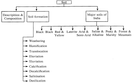
Soil is the mixture of rock debris and organic materials which develop on the earth's surface. Soil forms different layers of particles of different sizes. A vertical section that shows different layers of soil is called a Soil Profile. Each layer is called a Horizon.
Basic Facts
Primary minerals and Secondary minerals.
Soil Forming Processes - The transformation of rocks into soil is called soil formation.
The fundamental & specific process of soil formation are as follows -
Major Soil Groups of India
(i) Alluvial Soil
Difference between khadar and Bhangar
|
|
Khadar |
Bhangar |
|
(i) |
khadar is the newer and younger deposits of the flood plains |
Bhangar is the older alluvium. It forms the largest part of the Northern plains |
|
(ii) |
This type of alluvial soil found in the lower levels in the plains near the rivers. |
Bhangar found in higher up in the plains at river terraces away from rivers |
|
(iii) |
It is loamy and porous soil. |
It is clayey and non-porous soil |
|
(iv) |
It is more fertile than Bhangar as new layers are deposited year after year during monsoonal floods |
It is less fertile than khadar as it is not renewed. |
|
(v) |
It is pale brown, sandy clays & loams, more dry & leached less calcareous & carbonaceous |
It is generally dark coloured & of a more clayey composition. |
(ii) Black soils
(iii) Red and Yellow Soils
(iv) Laterite soils
(v) Arid and semi-arid soils
(vi) Saline and Alkaline soils
(vii) Peaty and Organic soils
(viii) Forest and Mountain soils
|
Soil Conservation Soil Conservation includes all those measures which help in protecting the soil from erosion and exhaustion. Following methods are normally adopted for conservation soil (1) Afforestatioh (2) Checking overgrazing: (3) Constructing Dams (4) Changing Agricultural Practices • crap rotation • strip cropping • contour ploughing • checking shifting cultivation |
Soils of India: Types, Depth, pH Range and Regional Distribution
|
Type |
pH range |
Distribution Predominant Crops |
Predominant Crops |
|
|
|
Alluvial Soil |
6.5-8.4 |
Ganga and Brahmaputra river valleys; deltas of Godavari and Krishna; Plains of Uttar Pradesh, Uttarakhand, Punjab, Haryana, West Bengal and Bihar; Coastal strip of peninsular India |
Rice, wheat, sugarcane, oilseeds, Jute, maize, vegetables & fruits. |
||
|
Desert Soil |
7.6-8.4 |
Rajasthan, northern Gujarat and southern Punjab |
Wheat, grams, melon, bajra (with irrigation), barley, cotton, maize, pulses. |
||
|
Black Soil |
6.5-8.4 |
Maharashtra and Malwa plateaus, Kathiawar peninsula, Telengana and Rayalasema region of Andhra and northern part of Karnataka, some parts of Tamil Nadu. |
Cotton, millets, tobacco, sugarcane (Millets include jowar, bajra and ragi), castor, sunflower. |
||
|
Red & yellow Soil |
Below 5.5- 7.5 |
Scattered in peninsular India, Eastern parts of Deccan plateau, southern states of Kerala, Tamil |
Millets, wheat, tobacco, rice, cotton, sugarcane, pulses, groundnut, potatoes, |
||
|
Latente Soil |
Below 5.5 |
Assam hills, Tamil Nadu, Madhya Pradesh, Kerala, Karnataka, and Eastern Ghat region of Orissa. |
Coffee, rubber, cashewnut, tapioca |
|
|
|
Mountain Soil (It includes peat, forest and hill soils) |
5.0-6.5 |
Coniferous forest belt of Jammu and Kashmir, Himachal Pradesh, Uttarakhand and Sikkim. |
Fruits, tea, coffee, wheat, maize, barley. |
|
|
|
Saline Soils |
|
Western Gujarat, deltas of Eastern Coast & in Sunderban areas of West Bengal |
|
|
|
|
Peaty & Marshy Soils |
|
Northern part of Bihar, Southern part of Uttaranchal & the coastal areas of West Bengal, Orissa & Tamil Nadu |
|
|
|
Rainfall
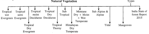
Natural Vegetation refers to a plant community that has been left undisturbed over a long time, so as to allow its individual species to adjust themselves to climate & soil conditions as fully as possible.
India State of Forest Report
The word forest is derived from Latin ‘fores’ meaning outside, the reference beging to a fence & it must have included all uncultivated & unhabited land.
Forest cover of India
|
Class Forest cover Very Dense Forest |
Area (sq. km) 85,904 |
Percentage of Geographical Area 2.61 |
|
Moderately Dense Forest |
315,374. |
9.59 |
|
Open Forest |
300,374 |
9,14 |
|
Total Forest Cover |
701,673 |
21.34 |
|
Scrub |
41,362 |
1.26 |
|
Non-Forest |
2,544,228 |
77.40 |
|
Total Geographical Area |
3,287,263 |
100.00 |
India’s Nature Vegetation
|
No. |
Vegetation type |
Distribution |
Characteristic vegetation |
|
1. |
Tropical Wet Evergreen Vegetation |
In areas where the annual rainfall is over 250 cm and the average annual humidity exceeds 77 per cent (North-East states, western portions of the Western Ghats and Andaman and Nicobar). |
Lofty, very dense, multilayered forest with mesosphytic evergreens, e.g., bamboos, ebony, rose- wood, champa, toon, jamun, mesa, white cedar, mahogony. |
|
2. |
Tropical Semi-Evergreen Vegetation |
Found in regions where the annual rainfall is between 200-250 cm and the humidity approaches 75% (Upper Assam, lower eastern Himalayas, Orissa, the Andaman and Nicobar islands & Western Coast). |
Evergreen trees mixed with deciduous ones, less dense but more gregarious e.g., aini, semul, gutel, kadam, irul, thorny bamboo, rosewood, Kusum, hollock bonsum, white cedar, Indian chestnut, champa, mango, bamboos etc. |
|
3. |
Tropical Dry Evergreen Vegetation |
In areas where the mean rainfall is about 100 cm, mostly from north-east monsoon, the mean annual humidity is 75%, and the mean annual temperature is \[28\text{ }{}^\circ \]C (Tamil Nadu coast). |
Short statured trees, with complete canopy, coriaceous leaved trees of short boles, no canopy layer differentiation, e.g., khirmi, jamun, kokko, toddy palm, tarrina, ritha, neem etc. |
|
4. |
Tropical Moist Deciduous Vegetation (Also known as monsoon forest) |
In areas having moderate rainfall of 100- 200 cm, a mean annual temperature of about \[27\text{ }{}^\circ \]C, and an average relative humidity of 60 to 75% (Western Ghats, Odisha, eastern coastal plains, and Himalayan foothills). |
Trees which shed their leaves during spring & early summer season, very useful forests because they yield valuable timber & several other forest products, heavily buttressed trees, shrubby undergrowth with patches of bamboos, climbers & canes, e.g. sal, teak, sandalwood, siris, palas, mahua, sisam, amia etc. |
|
5. |
Tropical Dry Deciduous Vegetation |
In areas where rainfall is less than 150 cm and dry period is relatively long (eastern Rajasthan, Kathiawar, rain shadow area of the Deccan plateau, Central India). |
Trees which grow relativity shorter then the tropical moist deciduous trees closed & uneven canopy. Examples include teak, sal, bijasal, palas, khair, tendu, rosewood, anjar etc. |
|
6. |
Tropical Thorny Vegetation |
Mostly prevalent in areas having very low rainfall, i.e., 50 cm to 75 cm, the annual mean temperature between \[25\text{ }{}^\circ \]C and \[30{}^\circ \]C, and the annual humidity less than 50% (Kutchh, Saurashtra, Punjab, Haryana, Rajasthan, Upper Ganga plains and the Deccan plateau). |
Open stunted forest breaking down into xerophytic bush, e.g., babul, accasia, Senegal, ber, khair, ak, neem, Cactii etc. |
|
7. |
Sub-Tropical Vegetation |
Found at 1,000-2000 m altitude in eastern and western Himalayas, and drier areas of Kashmir. |
Luxurious forests of evergreen species. Eg. - Oak, chestnut, ash, birch, pine, sal, chir pine, oak, wild olives. |
|
8. |
Himalayan Dry Temperate |
In the inner dry ranges of the Himalayas where precipitation is below 10 cm. (Ladakh Lahul, |
Predominantly coniferous forests with xerophytic shrubs, e.g., chilgoza, deodar, oak, maple, ash, |
|
9. |
Himalayan or Montane/ Mountain Moist Temperate Vegetation |
In the temperate eastern and western Himalayas, between 1,500 m and 3,300 m (Jammu and Kashmir, Himachal Pradesh, Uttarakhand, Sikkim and Darjeeling). |
Broad leaved evergreens mixed with dominant coniferous species, generally 30 to 50 m high, open forest with shrubby undergrowth, e.g., deodar, spruce, maple, ash, pine, fir, beach, etc. |
|
10. |
Himalayan or Montane/ Mountain Wet Temperate Vegetation |
Found between 1,800 m and 3,000 m of altitude (eastern Himalayas, Nilgiris, the Aruiamalai, Paini hills of South India, Sikkim, Nagaland, hills of West Bengal, Assam, Arunachal Pradesh) where average rainfall is between 150 cm and 300 cm. & humidity is over 80%. |
Evergreen forests, short-boleds branchy trees, dense and rounded leaves. Examples include oak, magnolia, chilauni, birch, plum, deodar, laurel and maple. |
|
11. |
Sub-Alpine and Alpine Vegetation |
Above 2,900 m of altitude in the eastern Himalayas and above 3,500 m of altitude in the western Himalayas and extends up to the snowline. |
Dwarf shrubs which degenerate into a low evergreen scrubs and into xerophytic vegetation; examples include fir, juniper, pine birch and Rhododendron, spruce. |
|
12. |
Littoral or Tidal or Delta or Swamp Vegetation |
In and around the tidal creeks and along the deltas of the rivers Ganga, Mahanadi, Krishna and Godavari. |
Evergreen trees having profuse growth and stiltlike roots, e.g., sundari in the great Sunderban delta, Rhiwphora, nipa fruiticans (a type of palm), palms, keora, amur etc. |
Mangroves
|
Mangroves of India |
|
|
State |
Mangrove |
|
East coast |
|
|
West Bengal |
Sunderbans |
|
Orissa |
Mahanadi, Bhitarkanika |
|
Andhra Pradesh |
Godavari, Krishna |
|
Tamil Nadu |
Pichavaram, Muthupet, Point Calimere |
|
West coast |
|
|
Gujarat |
Gulf of Kutch, Gulf of Khambat |
|
Goa |
Goa |
|
Karnataka |
Coondapur |
|
Maharashtra |
Achra/Ratnagiri |
|
Kerala |
Vembanad |
|
Other mangroves |
|
|
Andaman & Nicobar Islands |
Andaman islands & Nicobar islands |
|
State/UT |
Forest cover as Percentage of geographical area (%) |
|
Andhra Pradesh |
16.86 |
|
Arunachal Pradesh |
80.50 |
|
Assam |
35.28 |
|
Bihar |
37.27 |
|
Chhattisgarh |
41.18 |
|
Delhi |
11.88 |
|
Goa |
59.94 |
|
Gujarat |
7.46 |
|
Haryana |
3.64 |
|
Himachal Pradesh |
26.37 |
|
Jammu & Kashmir |
10.14 |
|
Jharkhand |
28.82 |
|
Karnatka |
18.87 |
|
Kerala |
44.52 |
|
Madhya Pradesh |
25.21 |
|
Lakshadeep |
84.96 |
|
Puduchery |
10.43 |
|
State/UT |
Forest Cover as Percentage of Geographical Area (%) |
|
Maharashtra |
16.46 |
|
Manipur |
76.54 |
|
Meghalya |
77.02 |
|
Mizoram |
90.68 |
|
Nagaland |
80.33 |
|
Punjab |
3.50 |
|
Rajasthan |
4.70 |
|
Sikkim |
47.34 |
|
Tamil Nadu |
18.16 |
|
Tripura |
76.04 |
|
Uttar Pradesh |
5.95 |
|
West Bengal |
14.64 |
|
Andman & Nicobar |
81.51 |
|
Chandigarh |
14.72 |
|
Dadra & Nagar Haveli |
42.97 |
|
Daman & Diu |
5.49 |
|
Uttrakhand |
45.80 |
WILDLIFE
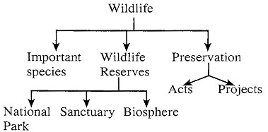
National Park: A reserved area meant for preserving its natural vegetation, wildlife and natural beauty.
Sanctuary: A reserved area meant for preservation and development of endangered species.
Biosphere: Multipurpose protected areas to preserve genetic diversity in representative ecosystems.
As of July 2015, there were 105 National Parks.
Number of wildlife Sanctuaries - 531
Number of Biosphere Reserves - 18.
Preservation of Wildlife
|
Distinction between National Park, Sanctuary and Biosphere Reserve |
||
|
National Park |
Sanctuary |
Biosphere Reserve |
|
• Habitat for particular wild animal species |
• Generally species-oriented such as citrus, pitcher plant. etc. |
• Ecosystem-oriented i.e. All forms of life |
|
• The general size range is 0.04 to 3162 sq. km. |
• The general size range is 0.61 to 7818 sq. km. |
• The general size range is over 5670 sq. km |
|
• Boundaries fixed by legislation |
|
• Boundaries fixed by legislation |
|
• Except the buffer zone, no interference |
• Boundaries are not sacrosanct |
|
|
|
• Limited biotic interference |
• Except the buffer zone, |
|
• Tourism permissible |
• Tourism permissible |
• no biotic interference |
|
• Research and Scientific management lacking |
• Research and Scientific management lacking |
• Tourism normally not permissible |
|
• So far no gene pool and |
• So far no gene pool and conservation given |
• Managed attention |
Endangered Species Projects
Project Tiger: The sort of India has taken a pioneering initiative for consuming tiger by launching the 'Project Tiger’ is 1973. India is home to 70% of tigers in the world. In 2014, there were 2,226 tigers. Statewise, Karnataka has the highest number of tigers (406) followed by 340 in Uttarakhand, 308 in Madhya Pradesh, 229 in Tamil Nadu. The project tiger aims to foster as exclusives tiger agenda in the core area of tiger reserves, which an inclusive people oriented agenda in the buffer. The largest tiger reserve is the Nagarjunsagar- Srisailam tiger reserve of Andhra Pradesh which covers the area of 3538 km2.
Project Elephant: Project elephant, a centrally sponsored scheme was launched in February 1992 to provide surgical and technical support to major elephant bearing states in the country for protection of elephants, their habitats and corridor.
The project is being implemented in 13 states/UT's viz. Andhra Kerala Meghlaya, Nagaland, Orissa, Tamilnadu, Utttranchal, Uttar Pradesh and West Bengal. There are 28 notified elephant reserve in India covering approximately 60,000 89 km area.
The Singhbhum Elephant Reserve, the first Elephant Reserve of India was created in 2001 under the Elephant project in Jharkhand.
India’s first exclusive hospital for Elephant will come up in
Kerala.
Project Snow Leopard: This project was lunched to safe guard and conserve India's unique natural habitats of high altitude wildlife population and their habitats by promoting conservation through participatory policies and actions. This project was drifted by Ministry of Environment and Forests, Govt. of India. It was launched in January. There are nearly 750 snow leopards in the country.
Memorandum of Understanding (MOU) or Siberian
Crane: This memorandum came into effect 1st July, 1993 and was amended is January, 1999. This memorandum was focuses on conserving the Siberian crane as one of these rarest crane species. India had signed the MOU on 13th Dec. 1998.
Siberian crane are migratory visitors to India in winter season.
MOU for Marine Twotle: Major threats to marine turtle include unexceptionable exploitation, distinction of resting and feeding habitats and incidental morality is fishing operations.
The objectives of this memorandum are conservation and management of Marine turtles and their habitats. India had signed this memo random on 20 February, 2007.
MOU for Dugong: The dugong is a seagrass dependent
Marine’s mammal of tropical and subtropical coastal water.
The dugong are vulnarable to human related influences due to their life history. Dugong is commonly known as sea cow.
In India, these are found is Indian waters. From Gujarat to Andaman and Nicobar Islands India had signed mou for Dugong on 28 May, 2008
|
Major Wildlife Reserves |
|||
|
1. Jammuand Kashmir |
Raksham Chitkul |
Keladevi |
Sanctuaries |
|
National Parks |
Renuka |
Kumbhalgarh |
Askot |
|
Dachigam |
Rupi Bhabha |
Mount Abu |
Binsar |
|
Hemis |
Sechu Tuan Nala |
Nahargarh |
Govind Pashu |
|
Kishtwar |
Shikari Devi |
National Chambal |
Kedarnath |
|
Sanctuaries |
Shilli |
National Garhial |
Sonanadi |
|
Baltal |
Simbalbara |
Phulwari |
|
|
Changthang |
Taira |
Ramgarh Bundi |
10. Madhya Pradesh |
|
Gulmarg |
Tirthan |
Sawai Mansingh |
National Parks |
|
Hirpora |
Tundah |
Shergarh |
Bandhavgarh |
|
Hokarsar |
|
Sita Mata |
Dinosaur Fossils |
|
Kanji |
3. Punjab |
Sunda Mata |
|
|
Karakoram |
Sanctuaries |
Todgarh Raoli |
Ghati |
|
Lachipora |
Abohar |
TalChapper |
Kanha |
|
Limber |
Harike Lake |
Van Vihar |
Madhav |
|
Nandini |
Bir Gurdialpura |
|
Panna |
|
Overa |
Bir Bunnerheri |
8. Uttar Pradesh |
Pench |
|
Overa-Aru |
Bir Motibagh |
|
Sanjay |
|
Ramnagar |
4. Haryana |
Dudwa |
Satpura |
|
Surinsar-Mansar |
Sultanpur |
Sanctuaries |
Van Vihar |
|
Tongri |
Sanctuaries |
|
Sanctuaries |
|
2. Himachal Pradesh |
Bir Shikargarh |
|
Achanakmar |
|
National Parks |
Chautala |
Chandra Prabha |
Badankhoh |
|
Great Himalayan |
|
Chilla |
Bagdara |
|
Pin Valley |
5. Delhi |
Hastinapur |
Barnawapara |
|
Sanctuaries |
Indira Priyadarshini |
Kaimur |
Bhairamgarh |
|
|
|
|
|
|
Bandii |
|
Kateraniaghat |
Bori |
|
Chail |
6. Chandigarh |
Kishanpur |
Gandhi Sagar |
|
Churdhar |
Sukhna |
Maahavir Swamy |
Ghatigaon |
|
Daranghati |
|
National Chambal |
Gomardah |
|
Darlaghat |
7. Rajasthan |
Nawabganj |
Karera |
|
Gamgul Siahbehi |
National Parks |
Ranipur |
Ken Gharial |
|
Gobind Sagar and Naina Devi |
Desert |
Samaspur |
Kuno-Palpur |
|
Kais |
Keoladeo |
Sohagabarwa |
Kheoni |
|
Kalatop & Khajjiar |
Ranthambore |
|
Narsingarh |
|
Kanawar |
Sariska |
|
National Chambal |
|
Khokhan |
Sanctuaries |
9. Uttaranchal |
Noradehi |
|
Kugti |
Bandh Bartha |
National Parks |
Pachmarhi |
|
Lippa Asrang |
Bassi |
Corbett |
Palpur |
|
Majathal |
Bhensrodgarh |
Gangotri |
Pamed Wild Buffalo |
|
Manali |
Darah |
Govind |
Panpatha |
|
Naina Devi |
Jaisamand |
Nanda Devi |
Pench |
|
Nargu |
Jamwa Ramgarh |
Rajaji |
Fensatallite |
|
Sailana Florican |
Udaipur |
16. Gujarat |
Jorpokhri |
|
Sanjay (Dubrj) |
|
Vansda |
Lothian Island |
|
Sardarpur Florican |
14. Jharkhand |
Gir |
Mahananda |
|
Samarsot |
Dalma |
Marine (Gulf of Kutch) |
Narendrapur |
|
Singhori (Sindhari) |
Gautam Buddha |
Velavadar/Blackbuck |
Pamadhan |
|
Sitanadi |
Hazaribagh |
|
Ramnabagan |
|
Sone Gharial |
Koderma |
Sanctuaries |
Raiganj |
|
Tamor Pingia |
Lawalong |
Balaram-Ambaji |
Sajnakhali |
|
Udanti Wild Buffalo |
Mahuadanr |
Barda |
Senchal |
|
11. Chhattisgarh |
Palamau |
Dhumkhal |
|
|
Indravati |
Parasnath |
Gir |
19. Sikkim |
|
Kanger Ghati |
Topchanchi |
Jambughoda |
National Parks |
|
|
|
Jessore |
Khangchendzonga |
|
12. Odisha |
I5. Maharashtra |
Khijadiya |
Sanctuaries |
|
National Parks |
National Parks |
Kutch Desert |
Fambong Lho |
|
Bhitar Kanika |
Gugamal |
Marine (Gulf of Kutch) |
Kyongasia Alpine |
|
Simlipal |
Nawegaon |
NalSarovar |
Maenam |
|
Sanctuaries |
Sanjay Gandhi |
Narayan (Chenkars) |
Shingba Rhododendron |
|
Badrama |
Tadoba |
Sarovar |
20. Manipur |
|
Baisipalli |
Sanctuaries |
Paniya |
Keibul Lamjao |
|
Balukhand Konark |
Andhari |
Purna |
Siroi |
|
Bhitarkanika |
Aner Dam |
Rampara |
Sanctuary |
|
Chandaka Dampara |
Bhimashankar |
Ratanmahal |
Yagoupokpi Lokchao |
|
Chilka Lake (Nalaban) |
Bor |
Shoolpaneshwar |
|
|
Debrigarh |
Chandoli . |
Wild Ass |
21. Meghalaya |
|
Hadgarh |
Chaprala |
|
Balphakram |
|
Karlapat |
Dhakna Kolkaz |
17. Goa, Daman and |
Nokrek |
|
Khalasuni |
Gandhari |
Diu |
Sanctuary |
|
Kotgarh |
Gautala Autramghat |
Bhagwan Mahavir |
Bhagmara |
|
Kuldiha |
Great Indian Bustard |
Sanctuaries |
Nongkhyllem |
|
Lakhari Valley |
Jaikwadi |
Bhagwan Mahavir |
Siju |
|
Satkosia Gorge |
Kalsubai Harishchandra |
Cotigao |
2 2. Arunachal Pradesh |
|
Simlipal Sunabeda |
Katepurna Koyna |
18. West Bengal National Parks |
Mouling Namdapha |
|
Ushakothi |
Malvan Marine |
Neora Valley |
|
|
|
Melghat |
|
Sanctuaries |
|
|
|
Singalila |
|
|
13. Bihar |
Nagzira |
Sundarban |
D'Ering Memorial |
|
Valmiki |
Nandur Madmeshwar |
|
Dibang Valley |
|
|
|
Sanctuaries |
|
|
Sanctuaries |
Painganga |
Buxa |
Eagle nest |
|
Bhimbandh |
Phansad |
Bibnutibhushan |
Itanagar |
|
Chandra Prabha |
Radhangiri |
Betuadahary |
Kamlang |
|
Kabar |
Sagareshwar |
Ballavpur |
Kane |
|
Kaimur |
Tansa |
Chapramari |
Mehao |
|
Nakti Dam |
Wainganga |
Gorumara |
Pakhui |
|
Rajgir |
Yawal |
Hallidav Island |
Sessa Orchid |
|
23. Mizoram |
Kawai |
Talakaveri |
Sanctuaries |
|
Murlen |
Kinnerasani |
|
Barren Island |
|
Phawngpui |
Kolleru |
29. Kerala |
Battimalve Island |
|
Sanctuaries |
Krishna |
Eravikulam |
Benett Island |
|
Dampa |
Lanjamadugu |
Periyar |
Bluff Island |
|
Khawnglung |
Manjira |
Silent Valley |
Bondoville Island |
|
Ngengpui |
Nagarjunasagar-Srisailam |
|
Buchaan Island |
|
|
Neelapattu |
Sanctuaries |
Cinque Island |
|
24. Nagaland |
Pakhal |
Aralam |
Crocodile (Lohabrrack) |
|
Nitangki |
Papikonda |
Chimony |
Defence Island |
|
Pulebatze |
Pocharam |
Chinnar |
East (Inglis) Island |
|
Fakim |
Pranahita |
Idukki |
East Island |
|
|
Pulicat |
Neyyar |
Flat Island |
|
25. Tripura |
Rollapadu |
Parambikulam |
Interview Island |
|
Charilam |
Srilanka Malleswara |
Peechi Vazhani |
James Island |
|
Sepahijala |
Siwaram |
Peppara |
Kyd Island |
|
Rishna |
|
Periyar |
Landfall Island |
|
Bison |
28. Karnataka |
Shendurney |
Narcondum Island |
|
Clouded Leopard |
National Parks |
Thattekkad Bird |
North Reef Island |
|
|
Anshi |
Wynad |
|
|
|
|
|
Paget Island |
|
26. Assam |
Bandipur |
30. Tamil Nadu |
|
|
Kaziranga |
Bannerghatta |
Guindy |
Pitman Island |
|
Nambiar |
Kudremukh |
Indira Gandhi |
Point Island |
|
Dibru-Saikhowa |
Nagarhole |
or Anamalai |
Ranger Island |
|
Sanctuaries |
|
Sanctuaries |
Fleet Island |
|
Dipor Beel |
Sanctuaries |
Kalakad |
Roper Island |
|
Garampani |
Arabithittu |
Karikili |
Ross Island |
|
Laokhowa |
Bhadra |
Mudumalai |
Sandy Island |
|
Manas |
Rangaswamy- Temple |
Mukurthi |
Shearme Island |
|
Nameri |
Biligiri |
Mundanthurai |
Sir Hugh Rose Island |
|
Orang |
Bramhagiri |
Point Call mere |
South Brother Island |
|
Pabha |
Cauvery |
Pulicat |
South Reef Island |
|
Pobitara |
Dandeli |
Srivilliputhur |
South Sentinel Island |
|
Sonai Rupai |
Ghataprabha |
Vedantangal |
Spike Island |
|
27. Andhra Pradesh |
Melkote Temple Mukambika |
Vettangudi |
Swamp Island |
|
National Parks |
Nugu |
31. The Andaman Islands |
Table (Delgarno) Island |
|
Shri Venkataswara |
Pushpagiri |
National Parks |
Table (Excelsior) Island |
|
Sanctuaries |
Ranganthittu |
Campbell Bay |
Talabaicha Island |
|
Coringa |
Ranebennur |
Galathea |
Temple Island |
|
Eturnagaram |
Sharavathi Valley |
Wandur |
Tillonchang Island |
|
Gundlabrahmeswaram |
Shettihally |
Mount Harriet Island |
West Island |
|
Koundinya |
Someswara |
Saddle Peak |
|
Biosphere Reserves of India
|
S. No. |
Name |
Type |
Key Funna |
Area (In Km2) |
|
1. |
Nilgiri Biosphere \[\Delta \] |
Western Ghat |
Nilgiri Tahr, |
5520 |
|
|
Reserve, Tamilnadu, Kerala Karnataka |
|
Lion talked macaque |
|
|
2. |
Nanda Devi, Utrakhand \[\Delta \] |
Western Himalyas Coast |
— |
5860 |
|
3. |
Gulf of Mannar, Tamilnadu \[\Delta \] |
East Himalayas |
Dugong |
10500 |
|
4. |
Nokrek, Meghalya \[\Delta \] |
Gangatic Delta |
Red Panda |
820 |
|
5. |
Sunderbans, West Bengal \[\Delta \] |
East Himalayas |
Royal Bengal Tiger |
9630 |
|
6. |
Manas, Assam |
Deccan Peniusula |
Red Panda |
2837 |
|
7. |
Simlipal, Odissa \[\Delta \] |
|
Royal Bengal Tiger, |
4374 |
|
|
|
Eastern Himalayas Semi-Arid |
Ganv, Wild elephant |
|
|
8. |
Dihang - dibang, Arunachal Pradesh |
Maikals Hills |
— |
5112 |
|
9. |
Panchmarhi Biosphere \[\Delta \] |
Desert |
Flying sq.uirrel |
4981.72 |
|
10. |
Amerkantak, Madhya Padesh Chhatisgarh \[\Delta \] |
Western Himalayas |
Giant Sq.uirrel |
3835 |
|
11. |
Rann of Kutch, Gujarat |
|
Indian wild ass |
12454 |
|
12. |
Pin valley national park |
East Himalayas |
Show Leopased |
7770 |
|
|
(Cold Desert), Himachal Pradesh |
Western Glats |
|
|
|
13. |
Khangchendzonga, Sikkim |
|
Red Panda |
2620 |
|
14. |
Agasthyamalai Biosphere resurve, Kerala, Tamilnadu |
Islands |
Nilgiri Tahr Elephants |
1828 |
|
15. |
Nicobar Biosphere Reserve, A & Nicobar, Islands \[\Delta \] |
East Himalayas |
Saltwater Crocodile |
885 |
|
|
|
Eastern Ghats |
|
|
|
16. |
Dibru-Saikhowa, Assam |
Catchment area of Ken River |
Golden Langur |
765 |
|
17. |
Seshachalam Hills, Andhra Pradesh |
|
|
|
|
18. |
Panna, Madhya Pradesh |
|
Tiger, Chital, Chinkara, |
543 |
|
|
|
|
Sembhar and Sloth bear |
|
|
\[\Delta \]Biosphere Reserves listed in UNESCO World Network of Biosphere Reserves. |
||||
|
Specialities of National Park and Sanctuary |
|
• Gir National Park in Gujarat is the only existent habitat for the nearly extinct Asiatic Lions in India. • The Kaziranga Sanctuary in Assam is a major habitat of the endangered Rhinoceros. • Periyar in Kerala is famous for the the wild Elephants • Dachigam National Park is natural habitat of Kashmiri Stag. • Nandankanan national park in Orissa serves as the natural habitat of white tigers. • The Padmaja Naidu Himalayan Zoological Park in Darjeeling (West Bengal) has undertaken Project Red Panda with a view to conserving this species. • The entire Little Rann of Kutch in Gujarat is known as the “Indian Wild Ass Sanctuary”. • Bhitarkanika in Orissa is a hot-spot of biodiversity. It’s home to largest population of giant salt water crocodile in India. • Gahirmatha, the only marine wildlife sanctuary of Orissa, is the most suitable natural place for Olive Ridley sea turtles’ for mating and nesting. • The National Chambal Sanctuary is famous for the rare gangetic dolphin and also for magar (crocodile) and gharial (alligator). • Ranganathittu Bird Sanctuary in Karnataka is a favourite abode for birds • Pakke Tiger reserve in East Kameng district of Arunachal Pradesh has won the ‘India Biodiversity Award 2016. |
|
National Parks by the largest area |
Wildlife Sanctuaries by the largest area |
||||
|
National Parks |
State |
Area (sq. km) |
Wildlife Sanctuary |
State |
Area (sq. km) |
|
1. Hemis |
Jammu & Kashmir |
4,100.00 |
1. Great Indian Bustard |
Maharashtra |
8,496.44 |
|
2. Desert |
Rajasthan |
3,162.00 |
2. Kachchh Desert |
Gujarat |
7,506.22 |
|
3. Namdapha |
Arunachal Pradesh |
1,807.82 |
3. Karakoram |
Jammu & Kashmir |
5,000.00 |
|
4. Khangchendzonga |
Sikkim |
1,784.00 |
4. Wild Ass |
Gujarat |
4,953.71 |
|
5. Gangotri |
Uttarakhand |
1,552.00 |
5. Dibang |
Arunachal Pradesh |
4,149.00 |
|
Western Ghats The Western Ghats (or Sahyadri) is a mountain range that runs parallel to the western coast of the Indian peninsula. It is a UNESCO World Heritage Site and is one of the 8 “hottest hotspots” of biological diversity in the world. The Western Ghats stretches into 6 states - Tamil Nadu, Kerala, Karnataka, Gujarat, Goa & Maharashtra. It hosts a large list of exceptional endemic species, the International Union for Conservation (IUCN) lists 5,000 vascular plant species, 228 freshwater fish species, 179 amphibians, 157 reptiles, 508 birds & 139 mammal species, some of the very rare species include the Great Indian Hornbill, Lion-Tailed Macaque, Travancore Turtles & Nilgiri Martens. In recent times 2 panels have been set up, under Madhav Gadgil & Kasturirangan, for protection of the Western Ghats. |
Agriculture
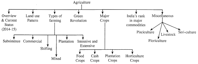
Agriculture includes raising of crops from the land, animal husbandry, agroforestry & pisciculture. India is an agriculturally important country. Two-thirds of its population is engaged in agricultural activities. Agriculture is a primary activity, which produces most of the food that we consume and raw material for various industries.
Overview of Agricultural Sector: Highlights (Source: - Economic Survey 2016-17)
|
(A) Foodgrains |
271.98 MT |
|
· Rice |
108.84 MT |
|
· Wheat |
96.64 MT |
|
· Coarse Cereals |
44.34 MT |
|
· Maize |
26.15MT |
|
· Pulses |
22.14MT |
|
· Tur |
4.23 MT |
|
· Gram |
9.12MT |
|
(B) Oilseeds |
33.60MT |
|
· Soyabean |
14.13MT |
|
· Groundnut |
8.47 MT |
|
(C) Cotton |
32.51 million bales |
|
(D) Sugarcane |
309.98 MT |
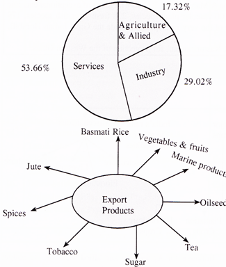
Diagram - Sectoral Share (%) in GVA at factor cost at current prices 2016-17
Land use Pattern
Area sown more than once: This area is used to grow more than one crop in a year. This accounts for 34.3% of the net sown area and 16.6 % of the total reporting area of the country.
This type of area comprises land with rich fertile soil and regulars water supply.
Forests: It is the area which the govt. has identified & demarcated for forest growth.
Land not available for cultivation: This class consists of two types of land (i) Land put to non-agricultural uses (ii) barren and unculturable waste.
Permanent pastures and other grazing land: It amounts to about 3.45% (i.e. 11.8 mha) of the total reporting area. The area presently under pastures is not sufficient keeping in view the large population of livestock in the country.
Land under miscellaneous tree crops and groves: It includes all cultivable land which is not included under net area sown, but is put to some agricultural use.
Culturable Wasteland: It includes all lands available for cultivation, but not cultivated for one reason or the other.
Types of Farming
India is a vast country and had various climatic patters and geographical condition, so these are different types of farming.
Advance machinery, chemical fertilizers, hybrid seeds and pesticides are used.
Cotton, sugarcane, tobacco, oil seeds, chillies etc. are commercial crops.
‘podu’ in Andhra Pradesh, 'Bewar' in M.P., ‘Kumari’ in Western Ghats.
Use of high efficiency machinery for planting, cultivating and harvesting as well as latest irrigation equipment.
Main crops season in India
|
Season |
Ground is Prepared |
Harvest |
Major crops of the season |
|
Kharif |
In April, May and the seeds are sown in June on arrival of rain. |
Beginning of November |
Rice, maize, Jowar, bajara, cotton, jute, groundnut, pulses etc. |
|
Rabi |
By end of October or beginning of November. |
April to June |
Wheat, barley, peas, gram, oilseeds, tobacco etc. |
|
Zaid |
It is summer season crops sown at beginning of the season in February and March |
April and May |
Urad, moong, melons, cucumber |
|
Wheat is cultivated with high yielding varieties of seeds like Lerma, Rajo, Sonora 63 and 64 (Mexican varieties), Sona 227, Kalyan Sona, Sonalika, Chhoti Lerma, Sharbati Sonora, Shera, Heera, Safed Lerma, UP 302, Saran, Champaran and C-l-7 etc. |
Green Revolution
The term “Green Revolution” is applied to the period from
1967 to 1978. The green revolution started by Dr. Norman
Borlaug in Mexico. Between 1947 and 1967, efforts at achieving food self-sufficiency were not entirely successful.
Population was growing at a much faster rate than good production. This called for drastic action to increase yield.
The action came in the form of the green revolution. The term green revolution is a general one that is applied to successful agricultural experiments in many countries. But it was most successful in India.
There were three basic elements in India regarding Green revolution
12 Components of the Green Revolution
High yield varieties (seeds), irrigation, use of fertilizers, use of insecticide and pesticide, command area development, consolidation of holding, land reform, supply of agricultural credit, rural electrification, rural roads and marketing, farm mechanisation, agricultural universities.
Impacts of Green Revolution
Impacts of Green Revolution are as follows
Positive Impact Increase in agricultural production, reduction of the import of foodgrains, capitalistic farming, industrial growth and rural employment.
Negative Impact Inter-crop imbalance, increase in regional imbalance, unemployment due to mechanisation. Increase in inter-regional migration, ecological problems and social conflict between large and small farmers.
Various Revolutions in Agriculture
|
Revolutions |
Area |
|
Green Revolution |
Agriculture (Food Production) |
|
Yellow Revolution |
Oil seeds production (Edible oil) |
|
White Revolution |
Milk |
|
Blue Revolution |
Fish |
|
Pink Revolution |
Shrimp, food processing |
|
Brown Revolution |
Coffee/Cocoa |
|
Red Revolution |
Meat/Tomato |
|
Golden Revolution |
Fruits/Apple/Honey/Horticulture |
|
Grey Revolution |
Fertilizers |
|
Silver Revolution |
Eggs/Poultry |
|
Golden Fibre |
Jute |
|
Silver Fibre |
Cotton |
MAJOR CROPS
Indian crops can be divided into following categories:
|
Crops |
Temp. (\[0{}^\circ \]C) |
Rainfall (cm) |
Soil |
Distribution |
|
Cash Crops |
|
|
|
|
|
Cotton (Gossypium) |
21-30 |
50-75 |
Black soil |
Gujarat, M.P., Kernataka, Maharashta, Punjab |
|
Jute (Corchorus Capsularis) |
24-35 |
125-200 |
Sandy or clayed loams, deep rich |
West Bengal Odisha Bihar Assam Meghalaya |
|
Sugarcane (saccnarum officinarum) |
20-26 |
75-150 |
Loamy soil |
Uttar Pradesh Maharashtra, Tamilnadu, Karnataka |
|
Tobacco (Nicotiana) |
15-38 |
50-100 |
Friable sandy soil |
Uttar Pradesh, Andhra Pradesh, Gujarat, Karnataka |
|
Food Crops |
|
|
|
|
|
Rice (oryza sativa) |
24-27 |
150 |
Clayed and loamy soil |
West Bengal, Karnataka, Andhara Pradesh, Assam Odisha, Uttar Punjab, Pradesh Telangana, Chhattisgarh |
|
Wheat (triticum) |
10-15 |
75 |
Light, sandy, clayed loamy soil |
Uttar Pradesh Punjab, Haryana, Rajasthan |
|
Jowar (Sorghum) |
27-32 |
30-65 |
Black clayed loamy soil |
Maharashtra, Karnataka, Madhya Pradesh, Andhra Pradesh |
|
Bajra (Penisetu Typhoidum) |
25-35 |
40-50 |
Loamy soil |
Rajasthan, Uttar Pradesh, Haryana, Maharashtra, Gujarat |
|
Plantation Crops |
|
|
|
|
|
Tea (Camellia Thea) |
24-30 |
150-250 |
Loamy forest soil |
Kerala, Tamil Nadu, West Bengal, Assam |
|
Coffee (coffea) |
16-28 |
150-250 |
Friable forest loamy soils |
Karnataka, Kerala, Tamil Nadu |
|
Rubber (Hevea Brasiliensis) |
25-35 |
300 |
Loamy soils |
Kerala, Karnataka, Tamil Nadu |
|
Spices (plantation crop) |
|
• India is the second largest producer of pepper. • India is the largest producer of ginger, cardamom and arecanut. • India is the third largest producer of coconut next to Philippines and Indonesia. • Kerala leads in the production of pepper, cardamom, ginger, arecanut and coconut among Indian states. • Andhra Pradesh is the largest producer of chillies and turmeric. • India is the largest producer, processor, consumer and exporter of cashew nut in the world. |
|
India’s Ranks in Major Commodity |
|
|
Rice |
2 |
|
Wheat |
2 |
|
Millets |
1 |
|
Tea |
2 |
|
Sugarcane |
2 |
|
Jute |
1 |
|
Silk |
2 |
|
Banana |
1 |
|
Mangoes |
1 |
|
Apple |
3 |
|
Cotton |
2 |
|
Buffalo Milk |
1 |
|
Pulses |
1 |
Fisheries/pisciculture
Livestock and Dairy Farming
Livestock includes domestic animals such as cattle, buffaloes, sheep, goats, horses, ponies, donkeys, camels, pigs etc. India’s Dairy Farming includes a class of agricultural enterprise for long-term production of milk which is processed for eventual sale of a dairy product. India is endowed with largest livestock population in the world. It accounts for about 57.3% of the world's buffalo population and 14.7% of the cattle population.
|
Different Breeds of Animals Milch Breeds of Cattle Gir, Sindhi, Red Sindhi, Sahiwal, Tharparkar and Deoni Draught Breeds of Cattle Nagori, Bauchaur, Malvi Hallikar, Ponwar, Siri, Bargur. Dual Purposse Breeds of Cattle Tharparkar, Haryana, Mewati, Kankrej, Rath, Nimari, Dangi, Ongole. Goats Breeds Angora, Pashmina, Barabari, Marwari, Mehsana Beetal, Kathiawari and Zaiwadi. Buffaloes Breeds Murrah, Jafarabadi, Shruti, Mehsana, Nagpuri, Nili Ravi, Bhadawari. Horses and Ponies Breeds Marwari, Kathiawari, Manipuri, Bhutani, Spiti and Chummarti. |
Sericulture
Sericulture refers to the rearing of the silk worms for the raw silk production. Silk is a protein produced form the salivary gland of silk worms.
Horticulture
Horticulture is a comprehensive term and includes fruits vegetables, spices, floriculture and coconut. Some of the most important crops grown in India as a part of the horticulture sector are: mango, cashewnut, apple, banana, orange, grape, peach, pear, apricot, strawberry and vegetables. Some important information regarding these fruits is given in the table.
Fruits Crops and their Favourable Climate, Distribution and Relevant Information
|
Fruit Crops |
Favorable Climate |
Distribution |
Relevant Information |
|
Apple |
Temperate fruit crop- It requires average temperature from \[21{}^\circ C\] to 4 C during the active growing season, 100-125 cm rainfall well distributed throughout the growing season. These conditions are found on the hill slopes at altitudes arranging from 1500-2700 m above sea level. |
Kullu and Shimla in Himachal Pradesh, Kashmir valley and hilly areas of Uttarakhand. |
Loamy soil, rich in organic matter, free from water logging are suitable for apple cultivation. |
|
Banana |
Primarily a tropical and sub-tropical crop requiring average temperature of \[20{}^\circ C\] to \[30{}^\circ C\] throughout the growing period and rainfall fairly above 150 cm. |
Tamil Nadu and Maharashtra are the two main producers |
India is the largest producer of banana in the world. |
|
Mango |
It is native of monsoon land and is grown in areas with temperature \[20{}^\circ C\] to \[30{}^\circ C\] and rainfall 75 cm to 250 cm. |
Uttar Pradesh. Bihar, Andhra Pradesh, West Bengal, Odisha, Kerala, Tamil Nadu are the major producers. |
India is the largest producer of mango and contributes 54 % of the world production of mango. |
|
Grapes |
It requires long summer, short winter and moderately fertile well drained soil. |
The major producing States are Uttarakhand, Himachal Pradesh. Jammu and Kashmir. |
In Northern India, the plant gives only one crop during summer, but in South India, the plant grows throughout the year, one in March, April and the other in August and September. |
|
Strawberry |
It requires above \[16{}^\circ C\] temperature during its growing season and lots of water because its fields are sub-merges under 10 cm of fresh and slowly moving water for atleast three months. |
The main producers are the hilly areas of Jammu and Kashmir, Himachal Pradesh, Uttarakhand. |
Water retaining fertile soil is most suitable. |
Floriculture
Government of India has identified floriculture as a sunrise industry and accorded it 100% export oriented status. Owing to steady increase in demand of flower, floriculture has become one of the important commercial trades in agriculture. Floriculture products mainly consist of cut flowers, pot plants, cut foilage, seeds bulbs, tubers, rooted cuttings and dried flowers or leaves.


You need to login to perform this action.
You will be redirected in
3 sec

