NCERT Extracts - Transport and Communication in India
Category : UPSC
Road Transport
- Road transport in modem sense was very limited in India before World War-II.
- The first serious attempt was made in 1943 when 'Nagpur Plan' was drawn. This plan could not be implemented due to lack of coordination among the princely states and British India.
- After Independence, twenty-year road plan (1961) was introduced to improve the conditions of roads in India. However, roads continue to concentrate in and around urban centres. Rural and remote areas had the least connectivity by road.
- Sher Shah Suri built the Shahi (Royal) road to strengthen and consolidate his empire from the Indus Valley to the Sonar Valley in Bengal.
- This road was renamed the Grand Trunk (GT) road during the British period, connecting Calcutta and Peshawar.
- At present, it extends from Amritsar to Kolkata. It is bifurcated into 2 segments:
- National Highway(NH)-l from Delhi to Amritsar, and
- NH-2 from Delhi to Kolkata.
National Highways
- The main roads which are constructed and maintained by the Central Government are known as the National Highways.
- The length of the National Highways has increased from 19,700 km in 1951 to 70,934 km in 2008-09.
- The National Highways constitute only 1.67 per cent of the total road length but carry 40 per cent of the road traffic.
- The National Highways Authority of India (NHAI) was operationalised in 1995.
- It is an autonomous body under the Ministry of Surface Transport. It is entrusted with the responsibility of development, maintenance and operation of National Highways. This is also the apex body to improve the quality of the roads designated as National Highways.
National Highways Development Projects
- NHAI has taken up some major projects in the country under different phases:
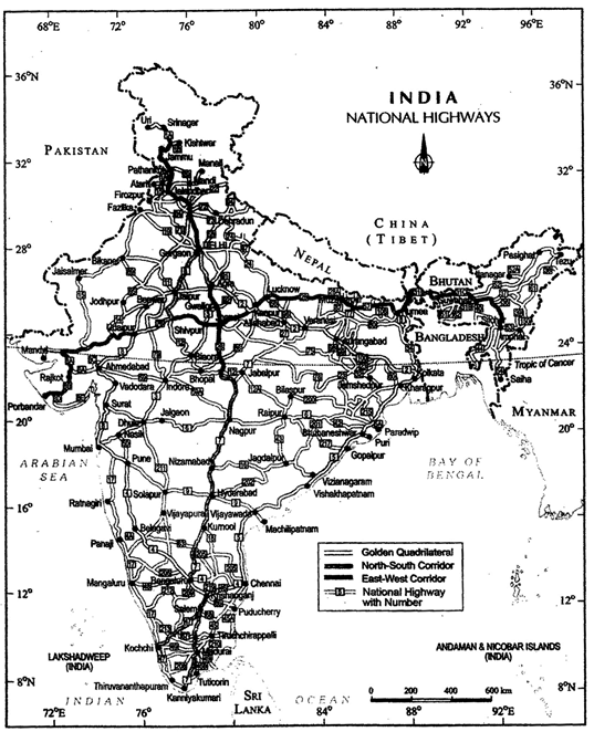
- Golden Quadrilateral: It comprises construction of 5,846 km long 4/6 lane, high density traffic corridor, to connect India's four big metro cities of Delhi-Mumbai- Chennai-Kolkata. With the construction of Golden Quadrilateral, the time-distance and cost of movement among the mega cities of India will be considerably minimised.
- North-South and East-West Corridors: North-South corridor aims at connecting Srinagar in Jammu and Kashmir with Kaniyakumari in Tamil Nadu (including Kochchi- Salem Spur) with 4,076 km long road. The East-West Corridor has been planned to connect Silchar in Assam with the port town of Porbandar in Gujarat with 3,640 km of road length.
National Highways
State Highways
- These are constructed and maintained by state governments. They join the state capitals with district headquarters and other important towns.
- These roads are connected to the National Highways. These constitute 4 per cent of total road length in the country.
District Roads
- These roads are the connecting link between District Headquarters and the other important nodes in the district. They account for 14 per cent of the total road length of the country.
Rural Roads
- These roads are vital for providing links in the rural areas. About 80 per cent of the total road length in India are categorised as rural roads.
Other Roads
- Other roads include Border Roads and International Highways.
- The Border Road Organisation (BRO) was established in May, 1960 for accelerating economic development and strengthening defence preparedness through rapid and coordinated improvement of strategically important roads along the northern and north-eastern boundary of the country.
- It is a premier multifaceted construction agency. It has constructed roads in high altitude mountainous terrain joining Chandigarh with Manali (Himachal Pradesh) and Leh (Ladakh). This road runs at an average altitude of 4,270 metres above the mean sea level.
- Apart from the construction and maintenance of roads in strategically sensitive areas, the BRO also undertakes snow clearance in high altitude areas.
- The international highways are meant to promote the harmonious relationship with the neighbouring countries by providing effective links with India.
- The distribution of roads is not uniform in the country. The density of road is high in most of the northern states and major southern states.
- It is low in the Himalayan region, northeastern region, Madhya Pradesh and Rajasthan.
- Why does this variation occur? Nature of terrain and the level of economic development are the main determinants of density of roads.
- Construction of roads is easy and cheaper in the plain areas while it is difficult and costly in hilly and plateau areas.
Rail Transport
|
Railway Zone
|
Headquarter
|
|
Central
|
Mumbai CST
|
|
Eastern
|
Kolkata
|
|
East Central
|
Hajipur
|
|
East Coast
|
Bhubaneswar
|
|
Northem
|
New Delhi
|
|
North Central
|
Allahabad
|
|
North Eastern
|
Gorakhpur
|
|
North East Frontier
|
Maligaon (Guwahati)
|
|
North Western
|
Jaipur
|
|
Southern
|
Chennai
|
|
South Central
|
Secunderabad
|
|
South Eastern
|
Kolkata
|
|
South East Central
|
Bilaspur
|
|
South Western
|
Hubli
|
|
Western
|
Mumbai (Church Gate)
|
|
West Central
|
Jabalpur
|
Railway Zone
- Indian railways network is one of the longest in the world. Mahatma Gandhi said, the Indian railways "brought people of diverse cultures together to contribute to India's freedom struggle."
- Indian Railway was introduced in 1853, when a line was constructed from Bombay to Thane covering a distance of 34 km.
- Indian Railways is the largest government undertaking in the country, in India, the railway system has been divided into sixteen zones.
- On the basis of width of the track of Indian Railways, three categories have been made:
- Broad gauge: The distance between rails in broad gauge is 1.676 metre. The total length of broad gauge lines was 55,188 km in 2011.
- Metre gauge: The distance between rails is one metre. Its total length was 6,809 km in 2011.
- Narrow gauge: The distance between the rails in this case is 0.762 metre or 0.610 metre. The total length of narrow guage was 2,463 km in 2011. It is generally confined to hilly areas.
Konkan Railway
- One of the important achievements of Indian Railways has been the construction of Konkan Railway in 1998. It is 760 km long rail route connecting Roha in Maharashtra to Mangalore in Kamataka.
- It is considered an engineering marvel. It crosses 146 rivers, streams, nearly 2,000 bridges and 91 tunnels.
- Asia's largest tunnel which is nearly 6.5 km long, also lies on this route. The states of Maharashtra, Goa and Kamataka are partners in this undertaking.
Water Transport
- It is a fuel-efficient and eco-friendly mode of transport.
- It was the chief mode of transport before the advent of railways. It, however, faced tough competition from road and railway transport.
- Moreover, diversion of river water for irrigation purposes made them non navigable in large parts of their courses. India has 14,500 km of navigable waterways, contributing about 1 per cent to the country's transportation. It comprises rivers, canals, backwaters, creeks, etc.
National Waterways of India
|
Waterways
|
Stretch
|
Specification
|
|
NW1
|
Allahabad-Haldia stretch (1,620km)
|
It is one of the most important waterways in India, which is navigable by mechanical boats up to Patna and by ordinary boats up to Haridwar. It is divided into three parts for developmental purposes- (i) Haldia-Farakka (560 km), (ii) Farakka-Patna (460 km), (iii) Patna-Allahabad (600 km).
|
|
NW2
|
NW 2 Sadiya-Dhubri stretch (891km)
|
.Brahmaputra is navigable by steamers up to Dibrugarh (1,3 84 km) which is shared by India and Bangladesh
|
|
NW3
|
Kottapuram-Kollam stretch (205 km)
|
It includes 168 km of west coast canal along with Champakara canal (23 km) and Udyogmandal canal (14 km). NW 4 Specified streches of Godavari and Krishna rivers along with Kakinada Puducherry stretch of canals (1078 km) NW 5 Specified stretches of river Brahmani along with Matai river, delta channels of Mahanadi and Brahmani rivers and East Coast canals (588km).
|
- At present, 5,685 km of major rivers are navigable by mechanised flat bottom vessels.
- For the development, maintenance and regulation of national waterways in the country, the Inland Waterways Authority was set up in 1986.
- Inland Waterways Authority has also identified ten other inland waterways, which could be upgraded. The backwaters (Kadal) of Kerala has special significance in Inland Waterway.
- Apart from providing cheap means of transport, they are also attracting large number of tourists in Kerala.
- The famous Nehru Trophy Boat Race (VALLAMKALI) is also held in the backwaters.
Indian Ports
- India has a vast coastline of approximate 7,517 km, including islands.
- Twelve major and 185 minor ports provide infrastructural support to these routes.
- Oceanic routes play an important role in the transport sector of India's economy.
- Approximately 95 per cent of India's foreign trade by volume and 70 per cent by value moves through ocean routes.
- Apart from international trade, these are also used for the purpose of transportation between the islands and the rest of the country.
- Kandia in Kuchchh was the first port developed soon after Independence to ease the volume of trade on the Mumbai port, in the wake of loss of Karachi port to Pakistan after the Partition.
- Kandia is a tidal port. It caters to the convenient handling of exports and imports of highly productive granary and industrial belt stretching across the states of Jammu and Kashmir, Himachal Pradesh, Punjab, Haryana, Rajasthan and Gujarat.
- Mumbai is the biggest port with a spacious natural and well-sheltered harbour.
- The Jawaharlal Nehru port was planned with a view to decongest the Mumbai port and serve as a hub port for this region.
- Marmagao port (Goa) is the premier iron ore exporting port of the country.
- This port accounts for about fifty per cent of India's iron ore export.
- New Mangalore port, located in Karnataka caters to the export of iron ore concentrates from Kudremukh mines.
- Kochchi is the extreme south-western port, located at the entrance of a lagoon with a natural harbour.
- Moving along the east coast, you would see the extreme south-eastern port of Tuticorin, in Tamil Nadu. This port has a natural harbour and rich hinterland. Thus, it has a flourishing trade handling of a large variety of cargoes to even our neighbouring countries like Sri Lanka, Maldives, etc. and the coastal regions of India.
- Chennai is one of the oldest artificial ports of the country. It is ranked next to Mumbai in terms of the volume of trade and cargo.
- Vishakhapatnam is the deepest landlocked and well-protected port. This port was, originally, conceived as an outlet for iron ore exports.
- Paradwip port located in Odisha, specialises in the export of iron ore.
- Kolkata is an inland riverine port. This port serves a very large and rich hinterland of Ganga- Brahmaputra basin. Being a tidal port, it requires constant dredging of Hoogly.
- Haldia port was developed as a subsidiary port, in order to relieve growing pressure on the Kolkata port.
Air Transportation
- Air transport in India made a beginning in 1911 when airmail operation commenced over a little distance of 10 km between Allahabad and Naini. But its real development took place in post-Independent period.
- The Airport Authority of India is responsible for providing safe, efficient air traffic and aeronautical communication services in the Indian Air Space.
- The air transport in India is managed by two corporations, Air India and Indian Airlines after nationalisation. Now many private companies have also started passenger services.
Air India
- Air India provides International Air Services for both passengers and cargo traffic. It connects all the continents of the world through its services.
- Pawan Hans is the helicopter service operating in hilly areas and is widely used by tourists in north-eastern sector.
- In addition, Pawan Hans Limited mainly provides helicopter services to petroleum sector and for tourism.
History of Indian Airlines
- 1947 - Air transport was provided by four major companies namely Indian National Airways, Tata Sons Limited, Air Services of India and Deccan Airways.
- 1951 - Four more companies joined the services, Bharat Airways, Himalayan Aviation Limited, Airways India and Kalinga Airlines.
- 1953 - Air transport was nationalised and two Corporations, Air India International and Indian Airlines were formed. Now Indian Airlines is known as 'Indian'.
- The country's largest state-owned domestic carrier, Indian Airlines dropped the word 'Airlines' from its name and is known as 'Indian' w.e.f. 8 December, 2005.
- The new brand name 'Indian' now appears on both sides of the fuselage. The logo on the orange tail depicting 'IA' has also been changed.
- It has been replaced by a new logo which is a partly visible blue wheel and is inspired by the Sun Temple at Konark (Odisha), symbolising timeless motion, convergence and divergence. It also embodies strength as well as trust that has stood the test of time.
Open Sky Policy
- To help the Indian exporters and make their export more competitive, the government had introduced an Open Sky Policy for cargo in April, 1992.
- Under this policy, foreign airlines or association of exporters can bring any freighters to the country.
Oil and Gas Pipelines
- Pipelines are the most convenient and efficient mode of transporting liquids and gases over long distances.
- Even solids can also be transported by pipelines after converting them into slurry. Oil India Limited (OIL) under the administrative set up of the Ministry of Petroleum and Natural Gas is engaged in the exploration, production and transportation of crude oil and natural gas. It was incorporated in 1959 as a company.
- Asia's first cross country pipeline covering a distance of 1,157 km was constructed by OIL from Naharkatiya oilfield in Assam to Barauni refinery in Bihar. It was further extended up to Kanpur in 1966.
- Another extensive network of pipelines has been constructed in the western region of India of which Ankleshwar-Koyali, Mumbai High-Koyali and Hazira-Vijaipur-Jagdishpur (HVJ) are most important.
- Recently, a 1,256 km long pipeline connecting Salaya (Gujarat) with Mathura (U.P.) has been constructed.
- It supplies crude oil from Gujarat to Punjab (Jalandhar) via Mathura. OIL is in the process of constructing of 660 km long pipeline from Numaligarh KySiliguri.
Communication Networks
- Radio broadcasting started in India in 1923 by the Radio Club of Bombay. Since then, it gained immense popularity and changed the sociocultural life of people. Within no time, it made a place in every household of the country.
- Government took this opportunity and brought this popular mode of communication under its control in 1930 under the Indian Broadcasting System. It was changed to All India Radio in 1936 and to Akashwani in 1957.
- Initially, the T.V. services were limited only to the National Capital where it began in 1959. After 1972, several other centres became operational.
- In 1976, TV was delinked from All India Radio (AIR) and got a separate identity as Doordarshan (DD).
- After INSAT-IA (National Television-DDl) became operational, Common National Programmes (CNP) were started for the entire network and its services were extended to the backward and remote rural areas.
- On the basis of configuration and purposes, satellite system in India can be grouped into two : Indian National Satellite System (INSAT) and Indian Remote Sensing Satellite System (IRS).
- The INSAT, which was established in 1983, is a multipurpose satellite system for telecommunication, meteorological observation and for various other data and programmes.
- The IRS satellite system became operational with the launching of IRS-IA in March, 1988 from Vaikanour in Russia. India has also developed her own Launching Vehicle PSLV (Polar Satellite Launch Vehicle).
- These satellites collect data in several spectral bands and transmit them to the ground stations for various uses.
- The National Remote Sensing Centre (NRSC) at Hyderabad provides facilities for acquisition of data and its processing. These are very useful in the management of natural resources.
Some Important Facts
- National Highway-7 is the longest and traverses 2,369 km between Varanasi and Kanyakumari via Jabalpur, Nagpur, Hyderabad, Bangalore and Madurai. Delhi and Mumbai are connected by National Highway-8, while National Highway-15 covers most of Rajasthan.
- Initial cost of laying pipelines is high but subsequent running costs are minimal. It rules out trans-shipment losses or delays.
- There are three important networks of pipeline transportation in the country.
- From oil field in upper Assam to Kanpur (Uttar Pradesh), via Guwahati, Barauni and Allahabad. It has branches from Barauni to Haldia, via Rajbandh, Rajbandh to Maurigram and Guwahati to Siliguri.
- From Salaya in Gujarat to Jalandhar in Punjab, via Viramgam, Mathura, Delhi and Sonipat. It has branches to connect Koyali (near Vadodara, Gujarat) Chakshu and other places.
- Gas pipeline from Hazira in Gujarat connects Jagdishpur in Uttar Pradesh, via Vijaipur in Madhya Pradesh. It has branches to Kota in Rajasthan, Shahajahanpur, Babrala and other places in Uttar Pradesh.
- Marmagao port (Goa) is the premier iron ore exporting port of the country
- This port accounts for about fifty per cent of India's iron ore export. New Mangalore port, located in Kamataka caters to the export of iron ore concentrates from Kudremukh mines.
- Kochchi is the extreme south-western port, located at the entrance of a lagoon with a natural harbour.
- Kolkata is an inland riverine port. This port serves a very large and rich hinterland of Ganga-Brahmaputra basin. Being a tidal port, it requires constant dredging of Hoogly.
- Haldia port was developed as a subsidiary port, in order to relieve growing pressure on the Kolkata port.
- The air transport was nationalised in 1953.
- The Central Board of Film Certification is the authority to certify both Indian and foreign films.