Solved papers for 12th Class Geography Solved Paper - Geography 2013 Delhi Set-I

done Solved Paper - Geography 2013 Delhi Set-I Total Questions - 26

  • question_answer1) Give the meaning of 'Crude Birth Rate' (CBR).

    View Answer play_arrow
  • question_answer2) How is sex ratio calculated in different countries of the world?

    View Answer play_arrow
  • question_answer3) State and two functions of World Trade Organization (W.T.O.).

    View Answer play_arrow
  • question_answer4) Which State of India has the lowest female literacy rate?

    View Answer play_arrow
  • question_answer5) Mention any two causes of the negative growth rate of population in India during 1911-1921.

    View Answer play_arrow
  • question_answer6) Give any two examples of mining towns in India.

    View Answer play_arrow
  • question_answer7) What is 'sectoral planning'?

    View Answer play_arrow
  • question_answer8) Why is the density of rural roads very low in the hilly areas of India? Give one reason.

    View Answer play_arrow
  • question_answer9) Give the meaning of the term hinterland.

    View Answer play_arrow
  • question_answer10) Mention any two sources of water pollution in India.

    View Answer play_arrow
  • question_answer11) Explain the concept of 'possibilism', with three suitable examples.

    View Answer play_arrow
  • question_answer12) Analyze any three major problems of slum dwellers in India.

    View Answer play_arrow
  • question_answer13) Explain any three points of economic significance of 'Trans-Siberian Railway'.

    View Answer play_arrow
  • question_answer14) What is cyber space? Describe any two advantages of internet.

    View Answer play_arrow
  • question_answer15) Explain with example, how 'stage of economic development' and foreign investment? become the basis of international trade.

    View Answer play_arrow
  • question_answer16) Explain any three push factors that have caused rural to urban migration in India.    

    View Answer play_arrow
  • question_answer17) What are hamleted settlements? Mention any two areas of India where such settlements are found.

    View Answer play_arrow
  • question_answer18) Give two advantages of 'copper' Mention four main copper mining areas of India.

    View Answer play_arrow
  • question_answer19) Explain the role of 'power' and 'raw-material' in the location of heavy industries in India.

    View Answer play_arrow
  • question_answer20) Explain any three human values which are required to empower socially and economically disadvantaged people.

    View Answer play_arrow
  • question_answer21) 
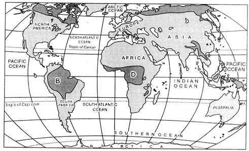
    Study the given map, showing areas of subsistence gathering carefully and answer the following questions:
    (i) Identify and name the areas marked A, B, C and D in your answer-book.                          
    (ii) Explain any four characteristics of gathering.
    (iii) Why can't gathering become important at the global level? Give two reasons.
     

    View Answer play_arrow
  • question_answer22) Define 'manufacturing'. Classify manufacturing industries on the basis of size into three categories. Explain an important characteristic of each category.

    View Answer play_arrow
  • question_answer23) Classify urban settlements on the basis of size, functions and services available into five categories and explain an important characteristic of each type.

    View Answer play_arrow
  • question_answer24) Explain any three factors responsible for the depletion of water resources. Examine any two legislative measures for controlling water pollution in India.

    View Answer play_arrow
  • question_answer25) Explain with five suitable examples, how the 'level of economic development' and 'nature of terrain' \[a\hat{u}ect\] the density of roads in India.

    View Answer play_arrow
  • question_answer26) 
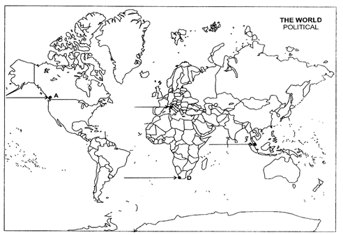
    (a) In the given political outline Map of the World, four features have been marked as A, B, C and D. Identify these features with the help of information given below and write their correct names on the lines drawn near them.
    A: A major sea port.
    B: A major airport.
    C: The country having the highest density of population in Asia.
    D: An area of extensive commercial grain farming.
    (b) Locate and label the following on the given political outline Map of India with appropriate symbols:
    (i) Mayurbhanj - iron ore mining area
    (ii) A major seaport which has been developed after independence to cater the needs of Western and North-western parts of the country.
    (iii) A state having highest female literacy rate.

    View Answer play_arrow

Study Package

Solved Paper - Geography 2013 Delhi Set-I


You need to login to perform this action.
You will be redirected in 3 sec spinner