
| Study the diagram given below and answer the questions that follow: |
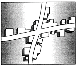 |
| (i) Identify and name the given rural settlement pattern. |
| (ii) In which type of areas do we find such type of settlement patterns? |
| (iii) Give an important characteristic of this type of settlement pattern. |
| Study the following diagram and answer the questions that follow: |
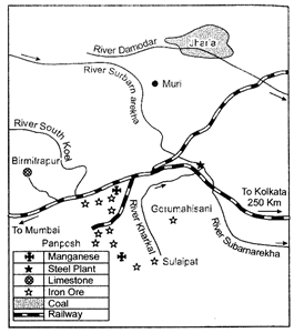 |
| (i) Identify and name the steel plant shown in this diagram. |
| (ii) Name the mining fields which supply coal and limestone to this plant. |
| (iii) Mention the source of water for this plant. |
| Five Geographical features shown on the given political outline map of the world as A, B, C, D and E. Identify these features with the help of the information given below and write their correct names on the lines marked near them: |
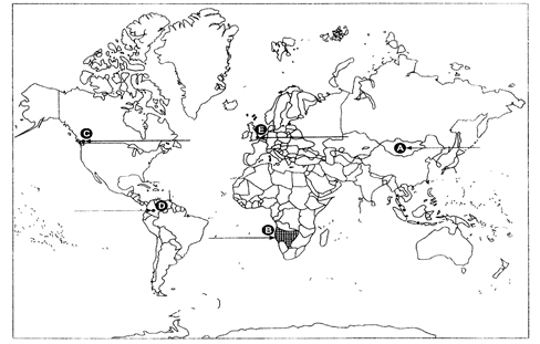 |
| (A) The country with lowest density of population in Asia. |
| (B) An area of nomadic herding. |
| (C) A major sea port |
| (D) An international airport |
| (E) A mega city |
| Locate and label the following on the given political outline map of India with appropriate symbols. |
| (i) The state having the highest density of population (2011). |
| (ii) The state with smallest rural population. |
| (iii) Mayurbhanj - an iron ore mining area. |
| (iv) An oil refinery in Karnataka state. |
| (v) The headquarter of South Central Railway Zone. |







You need to login to perform this action.
You will be redirected in
3 sec