CHAPTER-6 SOIL
Soils form an important part of the physical landscape of any region and linked with other components of physical landscape e.g. landforms, natural vegetation and the climate.
Soil is the thin layer of minerals covering the earth's surface and is formed from the weathering of rocks. It is made up mainly of mineral particles, organic materials, air, water and living organisms- all are interact with each other slowly but constantly.
Soil can be defined as the surface material accumulated on the bedrock over a period of time. It is made up of fine mineral fragments provided by the weathering of rocks and organic matter obtained from the remains of plants and animals. Soils are dynamic in their character and subject to change in its physical as well as chemical properties, under the influence of the local environmental and anthropological conditions.
Composition
Soil is a complex body composed of five major components -
- Mineral matter obtained by the disintegration and decomposition of rocks
- Organic matter, obtained by the decay of plant residues, animal remains and microbial tissues;
- Water, obtained from the atmosphere and the reactions in soil (chemical, physical and microbial).
- Air or gases, from atmosphere, reactions of roots, microbes and chemicals in the soil
- Organisms, both big (worms, insects) and small (microbes).
Soil Properties
All soils contain mineral particles, organic matter, water and air. The combinations of these determine the soil's properties-such as texture, structure, porosity, chemistry and colour.

Physical properties of Soil
Soil Colour
The most obvious feature of soil is its colour. Colour sometimes suggests the composition and chemical makeup of the soil. For example, the soils of the Deccan plateau region have a black colour which indicate its volcanic origin while those of deserts have a light yellow or reddish colour indicate having particles of salt and iron.
Soil color is influenced primarily by soil mineralogy - telling us what is specific in a soil. Soils which are high in iron are deep orange-brown to yellowish-brown. Those soils that are high in organic matter are dark brown or black. Color can also tell us how a soil ?behaves?? - a soil that drains well is brightly colored and one that is often wet and soggy will have a mottled pattern of grays, reds, and yellows.
Soil texture
The particles that make up soil are categorized into three groups by size - sand, silt, and clay. Sand particles and clay particles are the largest and the smallest respectively. Most soils are combination of these three. The relative percentage of sand, silt, and clay gives texture to soil. For instance a clay loam texture soil has nearly equal parts of sand, slit, and clay.
Soil structure
Soil structure is the arrangement of soil particles into small clumps, called Peds or aggregates. Soil particles (sand, silt, clay and even organic matter) bind together to form Peds. Depending on the composition and the conditions in which the peds formed (getting wet and drying out, or freezing and thawing, foot traffic, farming, etc.), the peds has a specific shape.
They could be granular (like gardening soil), blocky, columnar, platy, massive (like modeling clay) or single-grained (like beach sand). Structure correlates to the pore space in the soil which influences root growth and air and water movement.
Soil density
Soil density is the mass of dry soil per unit of volume, including the air space. Soil bulk density can vary substantially among different soil types and it is affected by arrangement of particles.
Soil porosity
Soil Porosity refers to the amount of pores or open space, between soil particles. Pore spaces may be formed due to the movements of roots, worms and insects; expandable gases trapped within these spaces by groundwater and the dissolution of the soil parent material. Soil texture can also affect soil porosity.
In healthy soil, these pores are large and plentiful enough to contain water, oxygen and nutrients that plants need to absorbs through their roots.

SOIL TEXTURES
|
Soil Types
|
Sand
|
Clay
|
Silt
|
|
Sandy Loam
|
65%
|
15%
|
20%
|
|
Clay Loam
|
33%
|
33.5%
|
33.5%
|
|
Loam
|
40%
|
18%
|
42%
|
|
Silty Clay
|
10%
|
45%
|
45%
|
|
Silt Loam
|
17%
|
13%
|
70%
|
Chemical properties of Soil
Soil colloids
Soil colloids are most active constituent of the soil and it determine the physical and chemical properties of the soil. These particles are smaller than one hundred thousandth of a millimeter. Like other soil particles, some colloids are mineral while others are organic. They are important because their surface attract soil nutrients, which are in the form of ions dissolved in soil water.
Soil acidity and alkalinity
- The soil solution also contains Hydrogen (H+) and Aluminum (Al+++) ions.
- The presence of these acid ions in the soil solution tends to make the solution acidic. As the acidic ions accumulate, the bases are released to the soil solution and they are generally leached below the root level, resulting into reduction of soil fertility.
- The degree of acidity or alkalinity of a solution is determined by the Ph value.
- A lower Ph value indicates a greater degree of acidity.
- The Ph value of 7 indicates a neutral soil while values greater than 7 indicate increasing Alkalinity.
- Slightly acidic soil is the most fertile for agricultural work; higher soil acidity is typical in areas of cold humid climate due to low decomposition of organic matter and accumulation of humus.
- On the other hand, the soils in arid and semi-arid regions are typically alkaline. Acidity of soil can be reduced by application of lime
Biological properties
- Microorganisms- Soil microorganisms occur in huge numbers and display an enormous diversity of forms and functions. Major microbial groups in soil are bacteria (including actinomycetes), fungi, algae (including cyanobacteria) and protozoa.
- Other organisms- Soil animals, especially the earthworms and some insects tend to affect the soil favorably through their burrowing and feeding activities which tend to improve aeration and drainage through structural modification of the soil column. In general, they affect soil chemical properties to a lesser extent though their actions indirectly enhance microbial activities due to creation of a more favorable soil environment
Soil Formation Process
There are five key processes by which soil is formed. They are following-
Leaching
Leaching is the removal of soluble components from the soil column. As water went down through the soil, it can carry away bases such as calcium, which is exchangeable ion in clay-humus complexes, lead to acidification through the substitution of hydrogen ions.
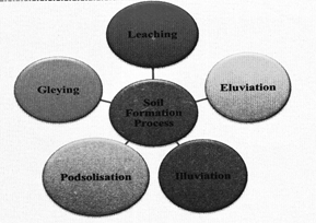
Eluviation
- It is the downward transport of fine particles from the uppermost part of the soil. Here soil particles held in suspension and clay are washed away.
Illuviation
- It is the accumulation of materials that are brought downward normally from E horizon to B horizon, here soil particles held in suspension and clay accumulated (eg. deposited).
Podzolization
- Podzolization occurs when strongly acid soil solutions cause the breakdown of clay minerals. As a result silica, aluminium and iron form complexes with organic substances in the soil. These minerals are removed from the surface zone of the soil and can accumulate in distinct dark sub-surface layers which are very evident on inspection. Upland heaths and moors often contain podzols.
Gleying
- Gleying occurs in waterlogged and in anaerobic conditions where iron compounds are reduced or either removed from the soil, or segregated out as mottles or concretions in the soil. Marshy wetlands often contain gleyed soils.
Process of Soil Formation
Soil formation or pedogenesis depends first on weathering. This weathering mantel (depth of the weathered material) is the basic input for soil to form. First, the weathered material or transported deposits are colonized by bacteria and other inferior plant bodies like mosses and lichens. Also, several minor organisms may take shelter within the mantle and deposits. The dead remains of organisms and plants help in humus accumulatioa. Minor grasses and ferns may grow; later, bushes and trees will start growing through seeds brought in by birds and wind. Plant roots penetrate down. Burrowing animals bring up particles as a result mass of material becomes porous and sponge-like with a capacity to retain water and to permit the passage of air and finally a mature soil which is the complex mixture of mineral and organic products forms.
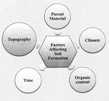
Soil-forming Factors
Five basic factors which control the formation of soils are following-
1. Parent material
2. Topography
3. Climate
4. Biological activity/Organic content
5. Time
Parent Material
Parent material is a passive control factor in soil formation. Parent materials can be any in-situ or on-site weathered rock debris (residual soils) or transported deposits (transported soils). Soil formation depends upon the texture (sizes of debris) and structure (disposition of individual grain/particles of debris) as well as on the mineral and chemical composition of the rock debris/deposits.
Nature and rate of weathering and depth of weathering mantle are important considerations under parent materials. There may be differences in soil over similar bedrock and dissimilar bedrocks may have similar soils above them. But when soils are very young and have not matured these show strong links with the different type of parent rock. Also, in case of some limestone areas, where the weathering processes are specific and peculiar, soils will show clear relation with the parent rock.
Topography
Topography like parent materials is another passive control factor. The influence of topography is felt through the amount of exposure of a surface covered by parent materials to sunlight and the amount of surface and sub-surface drainage over and through the parent materials. Soils will be thin on steep slopes and thick over flat upland areas. Over gentle slopes where erosion is slow and percolation of water is good, soil formation is very favorable. Soils over flat areas may develop a thick layer of clay with good accumulation of organic matter giving the soil dark colour.
Climate
Climate is an important active factor in soil formation. The climate elements involved in soil development are: (i) Moisture in terms of its intensity, frequency and duration of precipitation-evaporation and humidity; (ii) temperature in terms of seasonal and diurnal variations.
Precipitation gives soil its moisture content which makes the chemical and biological activities possible. Excess of water helps in the downward transportation of soil components through the soil (eluviations) and deposits the same down below (illuviation). In climates like wet equatorial rainy areas with high rainfall. Not only calcium, sodium, magnesium, potassium etc. but also a major part of silica is removed from the soil. Removal of silica from the soil is known as Desilication. In dry climates, because of high temperature, evaporation exceeds precipitation and hence ground water is brought up to the surface by capillary action and in the process the water evaporates leaving behind salts in the soil. Such salts form into a crust and in the soil known as hardpans. In tropical climates and in areas with intermediate precipitation conditions, calcium carbonate nodules (kanker) are formed.
Temperature acts in two ways- Increasing or reducing chemical and biological activity. Chemical activity is increased in higher temperatures, reduced in cooler temperatures (with an exception of carbonation) and stops in freezing conditions. That is why, tropical soils with higher temperatures show deeper profiles and in the frozen tundra regions soils contain largely mechanically broken materials.
Biological Activity/Organic content
The vegetative cover and organisms that occupy the parent materials from the beginning and also at later stages help in adding organic matter, moisture retention, nitrogen etc. Dead plants provide humus, the finely divided organic matter of the soil. Some organic acids which form during humification aid in decomposing the minerals of the soil parent materials.
Intensity of bacterial activity shows up differences between soils of cold and warm climates. Humus accumulates in cold climates as bacterial growth is slow. With undecomposed organic matter because of low bacterial activity, layers of peat develop in subarctic and tundra climates. In humid tropical and equatorial climates, bacterial action is intense and dead vegetation is rapidly oxidized leaving very low humus content in the soil. Further, bacteria and other soil organisms take gaseous nitrogen from the air and convert it into a chemical form that can be used by plants. This process is known as nitrogen
fixation. Rhizobium, a type of bacteria, lives in the root nodules of leguminous plants and fixes nitrogen beneficial to the host plant. The influence of large animals like ants, termites, earthworms, rodents etc., is mechanical. But, it is nevertheless important in soil formation as they rework the soil up and down. In case of earthworms, as they feed on soil, the texture and
chemistry of the soil that comes out of their body changes.
Time
Time is the third important controlling factor in soil formation. The time period that was taken during soil formation also determines maturation of soils and profile development. A soil becomes mature when all soil-forming processes act for a sufficiently long time and developing a profile. Soils developing from recently deposited alluvium or glacial till are considered young and they exhibit no horizons or only poorly developed horizons. No specific length of time in absolute terms can be fixed for soils to develop and mature.
Soil Horizon
A soil horizon is a layer parallel to the soil surface whose physical, chemical and biological characteristics differ from the layers of above and beneath. Horizons are defined in many cases by obvious physical features, mainly colour and texture. These may be described both in absolute terms (particle size distribution for texture, for instance) and in terms relative to the surrounding material, i.e. 'coarser' or 'sandier' than the horizons above and below.
1. O Horizon (Organic)
- It is composed of mainly organic matter such as decomposing leaves.
- It is thin in some soils, thick in others, while absent in many soils.
2. A Horizon or Topsail
- It is also called Humus Layer, which is rich in organic material.
- It gives the topsoil dark brown colour. The humus makes the topsoil soft, porous to hold enough air and water.
- In this layer, the seeds germinate and roots of the plants grow. Many living organisms like earthworms, millipedes, centipedes, bacteria and fungi are found in this layer of soil.
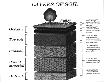
3. E Horizon - (Eluviated)
- It is also called subsurface horizon leached by process of irrigation and precipitation,
- This soil is leached of clay, minerals, and organic matter, leaving a concentration of sand and silt particles of quartz or other resistant materials. It is missing in some soils but often found in older soils and forest soils.
4. B Horizon or subsoil
- Just below the Horizon-E lies another layer called subsoil or horizon - B. It is comparatively harder and compact then topsoil.
- It is lighter in color than the topsoil because there is less humus in this layer. This layer is less organic but rich in minerals brought down from the topsoil.
- It contains metal salts, especially iron oxide in a large proportion Farmers often mix horizon- A and horizon- B while ploughing their fields.
5. Parent Material or Horizon- C
- It lies just below the subsoil. It contains no organic matter and made up of stones and rocks, so it is very hard.
- This layer represents a transition zone between the earth's bedrock and horizon A and B.
6. R Horizon of Bedrock
- Mass of rock such as granite, basalt, quartzite, limestone or sandstone that from the parent material for some soils. It is not a soil and is located below the C horizon. It is also called Saprolite.
Ingredients of Soil
The constituents of soil are as follows:-
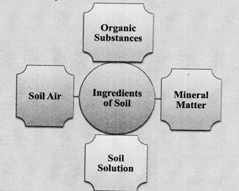
1. Organic substances
- Humus
- Vegetation and animal groups, organic matter
- Micro flora and micro organism
Humus
Humus is dark, organic material that forms in soil when plant and animal matter decays. When plants drop leaves, twigs, and other material to the ground, it piles up. This material is called leaf litter. When animals die, their remains add to the litter. Over time, all this litter decomposes. This means it decays, or breaks down, into its most basic chemical elements. Many of these chemicals are important nutrients for the soil and organisms that depend on soil for life, such as plants. The thick brown or black substance that remains after most of the organic litter has decomposed is called humus. Earthworms often mix humus
with minerals in the soil.
Humus contains many useful nutrients for healthy soil. One of the most important is nitrogen. Nitrogen is a key nutrient for plants. Agriculture depends on nitrogen and other utrients found in humus. Humus makes soil more fertile and helps prevent disease in plants and food crops.
When humus is in soil, the soil will crumble. Air and Water move easily through the loose soil, and oxygen can reach to the roots of plants.
Humus can be produced naturally or through a process called composting.
The functions of humus:-
- Increase the soil's ability to hold water.
- This makes the soil resistant and creates air gaps in the soil.
- It provides nitrogen and other nutrients to the plants for growth.
- It keeps the soil warm by absorbing heat.
- Organic acids produced by complete decomposition of humus act as solvents for soil materials.
- Humus increase immunity and exchange capacity of soil against chemical activity.
- It affects the soluble capacity of the mineral and acts as an energy source for the growth of microorganisms.
Vegetation and Animal groups and Organic matter
Soil components include plants and organisms (micro) and substances derived from them. These collectively contribute 5 to 12 percent of the total composition of the soil.
Organisms that live in soil are called Edaphons or soil organisms. The size of living organisms in soil varies from 20 centimeters to 20 micrometers in length. Soil organism are divided into three types-
1. Large-sized animals live in the soil and on the pile of leaves. Their length is more than one centimeter. They are both spinal and non-spinal. Some important ones in bone bearing spinal mammals are Mole rat. Armadillo, Rabbit, Squirrel, Gopher, Mole, Prairie dog, sharp-toothed animals such as a rat etc. Among the animals crawling with the
stomach are lizards and Snakes etc. Snail, Shambuk, Coat, Spider, Kutki, Kilni etc. are prominent under the bone bearing spineless animals.
2. Medium-sized animals have a body length of one centimeter to 0.2 millimeters. Among them are small sized gnat, various species of spider, Springtails, insect larvae, innumerable footed insect (Millipods), equal-footed animals etc.
3. Small-sized animals have a body length of less than 0.2 millimeters. Bacteria are prominent among them.
Some aspects of Soil organisms are very important for soil properties and their characteristics, such as-
- The length of time that animals spend in the soil.
- Eating habit of animals.
- Habitat of animals
- Mobility of animals
Micro-vegetation and Micro-organisms
Under the micro vegetation and micro-organisms the roots of trees, fungus, bacteria, Algae and soil protozoa are included. These organisms influence and determine the properties and characteristics of soils in any area or region on a large scale. Bacteria and fungi are helpful in the transfer, movement, transmission of energy and nutrients in the natural ecosystem Bacteria perform the following functions in soils-
- Rotting vegetation leaves and wood.
- Creating Humus.
- Separate and decompose organic materials.
- Rotating nutrients etc.
Functions of Algae and Moss-
- To supply organic materials in the minerals of the soil.
- Providing durability to soil structure.
- Providing nutrients to large plants.
- To ventilate the flounder soils.
- Getting atmospheric nitrogen and accumulating into soil etc.
Organic materials include the dead and decomposed parts of living plants and animals.
These have great importance in the soil such as-
- They are the main source of energy and food of the organisms.
- These provide nutrients to the plants.
- They are helpful in the manufacturing of soils.
- After the death of plants and animals, there is a continuous mixing of the decomposed material from them in the soil division.
- These are constantly decomposed and dissolved by the micro-organisms.
- They are always moving, rotating, shifting and recycling in the natural ecosystem.
Organic materials are composed in the following form- Dead organic matter and substances obtained from separation 85 percent,
- Plant root-10 percent.
- Edaphons - 5 percent.
Edaphons is composed of following -
- Bacteria and antinomycetes-40 percent.
- Other micro vegetation (fungi, moss and algae) - 40 percent.
- Earthworm etc-12 percent.
- Middle level animals- 3 percent.
- Other large animals - 5 percent.
2. Mineral Substances
Many mineral substances are found in the soil, which are called nutrients. Depending on the requirement, these mineral substances may be micronutrients that plants require in relatively small amounts or it can be Macronutrients whose plants have require in relatively high amounts.
Macronutrients
- Macronutrients can be broken into two more groups:-Primary and secondary nutrients
- The primary nutrients are nitrogen (N), phosphorus (P), and potassium (K). These major nutrients usually are lacking from the soil first because plants use large amounts for their growth and survival.
- The secondary nutrients are calcium (Ca), magnesium (Mg), and sulror (S). There are usually enough of these nutrients in the soil so fertilization is not always needed. Also, large amounts of Calcium and Magnesium are added when lime is applied to acidic soils. Sulfur is usually found in sufficient amounts from the slow decomposition of soil organic matter.
1. Primary Nutrients
Nitrogen (N)
- Nitrogen is a part of all living cells and is a necessary part of all proteins, enzymes and metabolic processes involved in the synthesis and transfer of energy.
- Nitrogen is a part of chlorophyll, the green pigment of the plant that is responsible for photosynthesis.
- Helps plants with rapid growth, increasing seed and fruit production and improving the quality of leaf and forage crops.
- Nitrogen often comes from fertilizer application and from the air (legumes get their N from the atmosphere, water or rainfall contributes very little nitrogen)
- A Nitrogen deficiency results in a loss of vigor and color, growth of plant became slow and leaves starts falling at the bottom of plants.
Phosphorus (P)
- Like nitrogen, phosphorus (P) is an essential part of the process of photosynthesis.
- Involved in the formation of all oils, sugars, starches, etc.
- Helps with the transformation and storation of solar energy into chemical energy; proper plant maturation; withstanding stress.
- Effects rapid growth.
- Encourages blooming and root growth.
- Phosphorus often comes from fertilizer, bone meal, and superphosphate.
- A shortage of phosphorous result in a late, deficient flowering, and wrinkling of the leaves, and a lack of vigor in general.
Potassium (K)
- It involved in regulation of water and transport of plant reserve substance.
- Potassium is absorbed by plants in larger amounts than any other mineral element except nitrogen and, in some cases, calcium.
- Helps in the building of protein, photosynthesis, fruit quality and reduction of diseases.
- Lack of potassium reduces plant resilience to dry spells and frosts or to a fungus attack this in turn result of lack of balance among nutrients
- Potassium is supplied to plants by soil minerals, organic materials, and fertilizer.
2. Secondary Nutrients
Calcium (Ca)
- In sufficiency causes yellow and brown spots on leaves.
- Calcium, an essential part of plant cell wall structure, provides for normal transport and retention of other elements as well as strength in the plant. It is also thought to counteract the effect of alkali salts and organic acids within a plant.
- Sources of calcium are dolomitic lime, gypsum, and superphosphate.
Magnesium (Mg)
- Magnesium is part of the chlorophyll in all green plants and essential for photosynthesis. It also helps activate many plant enzymes needed for growth.
- Soil minerals, organic material, fertilizers, and dolomitic limestone are sources of magnesium for plants.
- Deficiencies result in weak stalk, loss greenness and appearance of yellow brown spots
Sulfur(S)
- Essential plant food for production of protein.
- Promotes activity and development of enzymes and vitamins.
- Helps in chlorophyll formation.
- Improves root growth and seed production.
- Helps with vigorous plant growth and resistance to cold.
- Sulfur may be supplied to the soil from rainwater. It is also added in some fertilizers as an impurity, especially the lower grade fertilizers. The use of gypsum also increases soil sulfur levels.
Micronutrients
- Micronutrients are those elements essential for plant growth which are needed in only very small (micro) quantities. These elements are sometimes called minor elements or trace elements, but use of the term micronutrient is encouraged by the American Society of Agronomy and the Soil Science Society of America. The micronutrients are boron (B) copper (Cu), iron (Fe), chloride (Cl), manganese (Mn), molybdenum (Mo) and zinc (Zn). Recycling organic matter such as grass clippings and tree leaves is an excellent way of providing micronutrients (as well as macronutrients) to growing plants.
Boron (B)
- Helps in the use of nutrients and regulates other nutrients.
- Aids production of sugar and carbohydrates.
- Essential for seed and fruit development.
- Sources of boron are organic matter and borax
Copper (Cu)
- Important for reproductive growth.
- Aids in root metabolism and helps in the utilization of proteins.
Chloride (Cl)
- Aids plant metabolism.
- Chloride is found in the soil.
Iron(Fe)
- Essential for formation of chlorophyll.
- Sources of iron are the soil, iron sulfate, iron chelate.
Manganese (Mn)
- Functions with enzyme systems involved in breakdown of carbohydrates, and nitrogen metabolism.
- Soil is a source of manganese.
Molybdenum (Mo)
- Helps in the use of nitrogen
- Soil is a source of molybdenum.
Zinc (Zn)
- Essential for the transformation of carbohydrates.
- Regulates consumption of sugars.
- Part of the enzyme systems which regulate plant growth.
- Sources of zinc are soil, zinc oxide, zinc sulfate, zinc chelate.
Role of nutrients
- Structural components of cell constituents and its metabolically active compounds.
- In the maintenance of cellular organization e.g. Turgidity etc.
- In energy transformation.
- Enzyme-catalyzed reactions
- Plant reproduction.
3. Soil Solution
Soil in water occurs in the pore spaces in the soil and some of the particles of the soil absorb this water. The soil water is in fact a complex solution of minerals like carbonates, sulphates, chlorides, nitrates, phosphates etc. Too little of soil water precludes the utility of the soil for cropping and too much of soil water is also injurious to most of the plants.
4. Soil Air
Soil air also occupies the pores of the soils and the amount of air in a particular soil is dependent upon the pore space and the fact whether the soil is dry or wet. The dry soils have larger proportion of the pore space occupied by air. Soil air is usually rich in carbon dioxide which is important source of carbon for plants.
Soil Fertility
Soil fertility shows the ability of the soil to provide the right amount and balance of nutrients that the growth of crops and plants are going to depend on. To optimize crop production, it is important to maintain fertile soil with the right combination of plant nutrients as well as an optimum soil ph.
Soil productivity is heavily dependent on the fertility of the soil. It shows the soil?s ability to support plant and crop growth in its optimal environment. As it is dependent on the soil?s fertility, high soil productivity would need the soil is to be properly fertilized.
Factors of footing soil fertility
- Infiltration of water
- Soil structure
- Active Soil life
- Content of organic matter
- Minerals present in the soil
- Acidity or Soil pH
- Water Retention capacity of soil
- Water draining ability of the soil
- Nutrient release capability
- Parent soil characteristics
- Ground water
- Exploitable depth of the soil
Importance of Soil
- Soil is the backbone of our food security. Without healthy soils, farmers wouldn?t be able to provide us with food, fiber and fuel.
- Healthy soils act as a foundation for plants by supporting plant roots and keeping plants upright for growth.
- Soils act as a pantry for plants, storing and cycling essential nutrients and minerals that plants need to grow.
- Soils store water for plants.
- Soils maintain adequate aeration for plants, providing oxygen for microbes, insects and plant roots.
- Soils are habitats for beneficial soil microbes; these organisms are nature?s hidden helpers. They form synergistic relationships with plants to protect them from stress and provide them with nutrients, among other tasks.
- Soils are homes for many other organisms like insects that lay and hatch eggs in the soil.
- Soils filter surface water of dust, chemicals and other contaminants. This is why underground water is some of the cleanest sources of water
- Healthy soils help protect the plant from climate change.
- Healthy soils provide farmers with better crop yields and protect plants from stress.
- Healthy soils protect the land from erosion.
- Soils help control weeds, plant pests, and disease.?
- Soil acts as a holding facility for solid waste.
- Soils help regulate the Earth's temperature
- Healthy soils mitigate the impacts of extreme weather events.
- Soil is made up of 45% minerals, 25% water, 5% organic matter and 25% air.
Soil is a nonrenewable natural resource. According to the Food and Agriculture Organization (FAO), it can take hundreds to thousands of years to form a centimeter of soil. But, that single centimeter of soil can be lost in a single year due to erosion.
Problems Of Indian Soil
- Soil erosion
- Water logging
- Soil salinity and alkalinity
- Desertification
Soil Erosion
Soil erosion is a naturally occurring process that affects all landforms. In agriculture, soil erosion refers to the wearing away of a field's topsoil by the natural physical forces of water and wind or through forces associated with farming activities such as tillage.
Erosion, whether it is by water, wind or tillage, involves three distinct actions soil detachment, movement and deposition. Topsoil, which is high in organic matter, fertility and soil life, is relocated elsewhere "on-site" where it builds up over time or is carried "off-site" where it fills in drainage channels. Soil erosion reduces cropland productivity and contributes to the pollution of adjacent watercourses, wetlands and lakes.
Soil erosion can be a slow process that continues relatively unnoticed or can occur at an alarming rate, causing serious loss of topsoil. Soil compaction, less organic matter, loss of soil structure, poor internal drainage, salinisation and soil acidity problems are other serious soil degradation conditions that can accelerate the soil erosion process.
Types of Soil Erosion
Wind erosion
- Wind is a very important agent of soil erosion. The wind removes the dry, unconsolidated material. Wind erosion is more prevalent in the arid and semi-arid climates. The main remedy of wind erosion has been to keep as much of land as possible covered with vegetation and the planting of long lines of trees as wind breaks.
- Thousands of hectares of fertile lands of Rajasthan, Gujarat, western UP and Haryana are affected by wind erosion.
- Arid zones of North-western India are highly affected by wind erosion.
Water Erosion
- Water erosion is very simplistically speaking caused by rainfall, river flow, waves (wave action, hydraulic action and abrasion), corrosion, glacier movement, thawing, etc., while wind erosion is caused by wind picking up loose particles (deflation) that better the ground as they fly by (abrasion), causing additional particles to become loose and fly away.
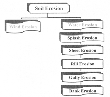
Types of Water erosion
Splash erosion is the first stage of the erosion process. It occurs when raindrops hit bare soil. The explosive impact breaks up soil aggregates so that individual soil particles are 'splashed' onto the soil surface.
It is widespread removal of surface debris and occurs because of the overland flow on low gradient slope generally at relatively slow speeds and over long periods. When continuously heavy rainfall occurs, sheet wash becomes sheet flood, and soil erosion becomes extremely severe as sheet erosion is accelerated. This type of soil erosion is widespread in the humid region.
The removal of surface material by the action of running water creates numerous tiny channels of few centimeters in depth, most of which carry water only during storms. Rilling is one of the most common forms of erosion. The rill channels can temporarily be obliterated by tillage. Tillage loosens the soil making it more susceptible to rill erosion. Thus, every time they are destroyed - the rills can reform, resulting in much more soil lost.
Gully erosion takes place when the storming rains produce a concentrated run-off thereby removing soil and other poorly consolidated sediments. The main cause of gully erosion is the removal of vegetation.
Natural streams and constructed drainage channels act as outlets for surface water runoff and subsurface drainage systems. Bank erosion is the progressive undercutting, scouring and slumping of these drainage ways. Poor. construction practices, inadequate maintenance, uncontrolled livestock access and cropping too close can all lead to bank erosion problems.
Soil erosion is the result of a number of factors working in isolation or in association with one another. Apart from the natural factors such as torrential rainfall, strong winds, nature of soil and slope, anthropogenic factors e.g. deforestation, overgrazing faulty methods of agriculture etc. are reasons of the erosion.
- Other causes of Soil Erosion
1. River- The River erodes soil in three ways
- The river forms a ravine by erosion. Examples of ravines are found in the alluvial regions of Chambal and Yamuna
- When the river changes its course, it erodes the surrounding area.
- At the time of flood, the water of river spreads far and wide and takes away the upper fertile layer of soil.
2. Torrential rainfall
- When there is torrential rainfall, the rainwater flows on the ground at a rapid rate and erodes the upper layer of soil. This type of rainfall is very harmful for agricultural field.
3. Slope of land
- Erosion is less on flat land but more on slopy land like mountains and hills.
4. Air
- Air is the biggest cause of soil erosion in arid desert areas. Soil erosion by wind depends on wind speed. Fast moving air erodes in large quantities.
5. Farming
- Agriculture is probably the most significant activity that accelerates soil erosion because of the amount of land that is farmed and how much farming practices disturb the ground. Farmers remove native vegetation and then plough the land to plant new seeds. Because most crops grow only in spring and summer, the land lies fallow during the remaining part of the year. So wind and rain are available to wash soil away. Tractor tyres make deep grooves, which are natural pathways for water. Fine soil is blown away by wind. The soil that is most likely to erode is the nutrient-rich topsoil, which degrades the farmland.
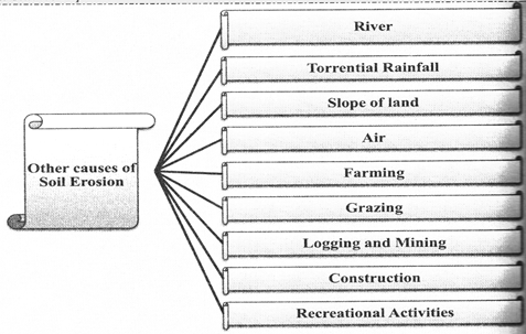
6. Grazing
- Grazing animals, wander over large areas of pasture or natural grasslands eating grasses and shrubs. Grazers expose soil by removing the plant cover for an area. They also chum up the ground with their hooves. If too many animals graze the same land area, the animal hooves pull plants out by their roots. A land is overgrazed if too many animals are living there.
7. Logging and Mining
- Logging removes trees that protect the ground from soil erosion. The tree roots hold the soil together and the tree canopy protects the soil from hard falling rain. Logging results in the loss of leaf litter, or dead leaves, bark, and branches on the forest floor.
- Leaf litter plays an important role in protecting forest soils from erosion
8. Construction
- Constructing buildings and roads chums up the ground and exposes soil to erosion. In some locations, native landscapes, such as forest and grassland, are cleared, exposing the surface to erosion.
9. Recreational Activities
- Recreational activities may accelerate soil erosion. Off-road vehicles disturb the landscape and the area eventually develops bare spots where no plants can grow. In some delicate habitats, even hikers' boots can disturb the ground, so it's important to stay on the trailSoil erosion is as natural as any other type of erosion, but human activities have greatly accelerated soil erosion. In some locations soil erosion may occur about 10 times faster than its natural rate.
Effects of Soil erosion
Soil erosion has adverse effects which are reflected in following points:
- Top soil is eroded which leads to loss of soil fertility and fall in agricultural productivity.
- Flooding and leaching result in loss of mineral nutrient.
- Ground water level is lowered and there is decrease in soil moisture
- Natural vegetation cover dries up and arid land expand
- Frequency and intensity of floods and drought increases.
- Rivers, canals and tanks are silted and their water holding capacity decreasing.
- The incidence and damaging power of landslides increases.
- Due to the excessive soil erosion may cause the problem of food security.
Water Logging
- Water logging is the phenomenon of a rising water-table. If the water table rises close to the root systems, it affects the oxygen absorption by the roots and the crop yield.
- As moisture in the soil evaporates transpired salt are left behind and there occurs no leaching, this affects the soil quality. It mainly affects fertile land.
- Water logging has affected substantial tracts of land along the Indira Gandhi Canal (Rajasthan) and the canals of Punjab, Haryana and Uttar Pradesh.
- Major Causes of Water logging:-
- Seepage of water from canals
- Fault on farm water management
- Lack of adequate drainage
- Interception of natural drainage
- Indiscriminate cultivation in bed of drainage channel
- Inundation in coastal areas during cyclonic storms.
Salinity and Alkalinity
- Soil salinity and alkalinity are found in the relatively less rainfall recording areas where the rate of evaporation is generally high than the rate of precipitation.
- Also because of over-irrigation, a large area of irrigated land has become saline. The salt lodged in the lower profiles of the soil comes up the surface by capillary action and destroys its fertility.
- It also develops in the khaddar lands and the canal irrigated areas.
- Under such conditions, the ground water level rises and saline, alkaline efflorescence consisting of salts of sodium, calcium and magnesium appear on the surface as a layer of white salt through capillary action.
Desertification
Desertification can be defined as spread of desert like condition in arid or semi-arid areas due to anthropogenic cause or climate change. These areas are characterized by scanty rainfall, sparse vegetation cover and acute scarcity of water. Desert soils suffer maximum erosion by wind. The sand carried by wind is deposited on the adjoining fertile lands where
fertility dwindles and sometimes the fertile land merges with the advancing desert. Desertification results in persistent degradation of dry land and fragile ecosystems due to man-made activities and variations in climate.
Causes
The process of desertification is attributed to various causes of which more important are overgrazing, reckless felling of trees, growing population, climate change. Other factors that cause desertification include urbanization, overdrawing of groundwater deforestation, natural disasters, and tillage practices in agriculture that makes soils more vulnerable to wind erosion.
- Measures of controlling desertification
- Intensive tree plantation programme should be initiated.
- Grazing should be controlled and new pastures should be developed
- Mulching of shifting sand dunes should be put in place
- Indiscriminate felling of trees should be banned
- Alternative sources of fuel can reduce the demand for fuel wood
Soil Degradation
- Soil degradation is the decline in soil condition caused by its improper use or poor management, usually for agricultural, industrial or urban purposes. It is a serious environmental problem. Soils are a fundamental natural resource, and are the basis for all terrestrial life. Avoiding soil degradation is crucial for our well-being.
- Depletion of nutrients and soil organic matter and erosion are the principal forms of soil degradation. The intensive and increasing pressure on land leads to its degradstion and pollution, which may result in a partial or complete loss of its productive capacity. Soil degradation can be defined as a process by which one or more of the potential ecological functions of the soil are harmed or destroyed. Soil degradation is a process that lowers the current and future capacity of the soil to produce goods and services.
- Soil degradation can be either a result of natural hazards or due to unsuitable land use and inappropriate land management practices. Mismanagement of arable areas by farmers, cultivation practices that are not adapted to local environments and overgrazing by livestock are seen as the major causes of soil degradation.
- Natural hazards which can lead to soil degradation include land topography and climatic factors such as steep slopes, frequent floods and tornadoes, blowing of high velocity wind, rains of high intensity and drought conditions in dry regions. The most prominent degradation feature worldwide is erosion by water.
Soil Conservation
- Soil conservation is the prevention of loss of the top most layer of the soil from erosion.
- Reversing the degradation of soil, water and biological resources and enhancing crop and livestock production through appropriate land use and management practices are essential components in achieving food and livelihood security.
- Symptoms of soil degradation are numerous and include decline of soil fertility, development of acidity, salinization, alkalization, deterioration of soil structure, accelerated wind and water erosion, loss of organic matter and biodiversity.
- As a result, farm labour productivity and revenues from agriculture are falling, migration to urban areas is increasing, and rural poverty is exacerbated.
- Efforts to restore productivity of degraded soils must be coupled with other measures that affect the land use practices in particular conservation agriculture, good agricultural practices and irrigation management and integrated plant nutrient management.
Methods of Soil Conservation
1. Crop Rotation
- In many parts of India, a particular crop is sown in the same field year after year. It leads to exhaustion of certain nutrients in the soil and making it infertile.
- Crop rotation is a practice in which a different crop is cultivated on a piece of land each year. It helps to conserve soil fertility as different crops require different nutrients from the soil.
- Crop rotation provides enough time to restore lost nutrients.
- For example, potatoes require much potash but wheat requires nitrate. Thus, it is best to alternate crops in the field.
- Legumes such as peas, beans, and many other plants add nitrates to the soil by converting free nitrogen in the air into nitrogenous compounds by bacteria present in the root nodules.
2. Strip Cropping
- Crops may be cultivated in alternate strips, parallel to one another, Some strips may be allowed to lie fallow while in others different crops may be sown.
- Various crops are harvested at different intervals. This ensures that at no time of the year the entire area is left bare or exposed.
- The tall growing crops act as wind breaks and the strips which are often parallel to the contours help in the increasing water absorption by the soil by slowing down run off.
3. Contour Ploughing
- It involves ploughing parallel to the contours of a hill slope to form a natural barrier of water to flow down the slope
- If ploughing is done at right angles to the hill slope, the ridges and furrows break the flow of water down the hill.
- It prevents excessive soil loss and gullies are less likely to develop and also reduce run-off so that plants receive more water.
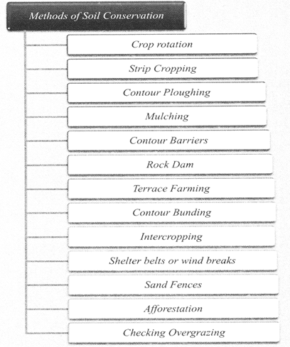
4. Mulching
- The bare ground (top soil) between plants is covered with a protective layer of organic matter like grass clippings, straw, etc.
- It retains soil moisture and thus protects the soil from erosion. It also reduces compaction from the impact of heavy rains.
- It conserves moisture, reducing the need for frequent watering and maintains even soil temperature. It also prevents weed growth.
- Organic mulches also improve the condition of the soil. As these mulches slowly decompose, it provides organic matter which keeps the soil loose.
5. Contour Barriers
- Stone, grass, soil are used to build barriers along contours. Trenches are made in front of the barriers to collect water.
- hey intercept down slope flowing water and soil particles. These barriers slow down the water movement and reduce its erosive force.
- They also litter out and trap many of the suspended soil particles, keeping them from being washed out of the field.
- A long term advantage of barriers is that soil tends to build up behind them, creating a terrace effect.
- Barriers can be classified as live (strips of living plants), dead (rock, crop residues), or mixed (a combination of the previous two).
6. Rock dam
- Rocks are piled up across a channel to slow down the flow of water which prevents gully formation and further soil loss.
7. Terrace farming
- In terracing, a number of terraces are cut along the hill slope.
- It is made on the steep slopes so that flat surfaces are available to grow crops. It can reduce surface run-off and soil erosion.
8. Contour Bunding
- It involves the construction of banks along the contours.
- Terracing and contour bunding divide the hill slope into numerous small slopes, check the flow of water and promote absorption of water by soil and save soil from erosion.
- Retaining walls of terraces control the flow of water and help in reducing soil erosion.
9. Intercropping
- It involves growing different crops in alternate rows to protect the soil from rain wash.
10. Shelter belts or Wind breaks
- In the coastal and dry region, rows of trees are planted to check the wind movement and to protect soil cover.
11. Sand Fences
- Sand fences are barriers made of small, evenly spaced wooden slate or fabric. They are erected to reduce wind velocity and to trap blowing sand.
- Sand fences can be used as perimeter controls around open construction sites to keep sediments from being blown offsite by the wind.
12. Afforestation
- It includes the prevention of forest destruction along with growing new forests or increase area under forests.
- Tree reduces the intensity of runoff and increase the seepage of water to the underground water-table.
- Social forestry can be developed along the banks of rivers, canals, lakes, roads, and railway tracts
13. Checking Overgrazing
- Overgrazing accentuates erosion. During the dry period, there is shortage of fodder and the grass is grazed to the ground and torn out the roots by animals.
- Soil is pulverized (reduce to fine particles) by the hoofs of animals. All this leads to weakened the top layer
- Over grazing can be checked by creating grazing grounds and producing larger quantities of fodder.
Soil Health Card
- Soil Health Card Scheme is a scheme launched by the ministry of agriculture in 19 February 2015.
- SHC is a printed report that a farmer will be handed over for each of his holdings. It will contain the status of his soil with respect to 12 parameters, namely N,P,K (Macro- nutrients); S (Secondary- nutrient); Zn, Fe, Cu, Mn, Bo (Micro - nutrients); and pH, EC, OC (Physical parameters). Based on this, the SHC will also indicate fertilizer recommendations and soil amendment required for the farm.
- The card will contain an advisory based on the soil nutrient status of a farmer's holding. It will show recommendations on dosage of different nutrients needed. Further, it will advise the farmer on the fertilizers and their quantities he should apply, and also the soil amendments that he should undertake, so as to realize optimal yields.
- The State Government will collect samples through the staff of their Department of Agriculture or through the staff of an outsourced agency. The State Govemment may also involve the students of local Agriculture/Science Colleges.
- Soil Samples are collected generally two times in a year, after harvesting of Rabi and Kharif Crop respectively or when there is no standing crop in the field.
Objectives of SHC
- To improve soil quality and profitability of farmers.
- Employment generation for rural youth.
- To update information on soil analysis.
- To provide soil testing facilities to farmers at their doorstep.
Benefits of the Soil Health Card Scheme
- The scheme will monitor the soil of the farmers and will give them a formatted report. So, they can decide in better way which crops they should cultivate and which ones they should skip.
- The authorities will monitor the soil on a regular basis. One in every 3 years, they will provide a report to farmers. So, farmers need not worry if the nature of the soil changes due to certain factors. Also, they will always have updated data about their soil.
- The work of the government does not stop at listing down measures required to improve the quality of the soil. In fact, they will also employ experts to help farmers in carrying out the corrective measures.
- Farmers will get a proper soil health report Also they can study the soil management practices. Accordingly, they can plan the future of their crops and land.
- Generally, in government schemes, the person carrying out the study for a particular farmer gets changed. But in the Soil Health Card Scheme, the government is paying attention that the same person carries out soil analysis for a farmer. This will further enhance the effectiveness of the scheme.
- The soil card will give the farmers a proper idea of which nutrients their soil is lacking. And hence, which crops they should invest in, they will also know which fertilizers they need. So, ultimately, the crop yield will see a rise.
- The main aim behind the scheme was to find out the type of particular soil and then provide ways in which we can improve it. Even if a soil has some limitations, we can do something to get the most out of it. And that is what the government is trying to do with the help of this scheme.
- After getting SHC farmers have reduced N, P and K use, especially nitrogen use has decreased and increased micronutrients use which helped them to increase the fertility.
problems with Soil Health Card
- Many farmers are unable to understand the content, hence unable to follow the recommended practices.
- Number of soil samples per unit area is not based on soil variability.
- Lack of Coordination among agricultural extension officers and farmers.
- Microbial activity, moisture retention activities are essential but missing in SHC.
- The soil health card is more focused on chemical nutrient indicators; among physical and biological properties only soil color is included.
- Some important indicators (i) Cropping history,(ii) Water resources (soil moisture), (iii) Slope of soil, (iv) Depth of soil (v) Color of soil, (vi) Soil texture (bulk density) and (vii) Micro-biological activity etc are not included.
Inadequate soil testing infrastructure.
What needs to be done?
There is a need for demonstration of benefits of SHC on an experimental basis in each block by adopting a comprehensive approach (systematic and scientific analysis of soil and water) and adoption of recommended doses.
- A specialized body is needed both at central as well as at state government leve for the management of soils. They should be given responsibility of monitoring the quality of service by various agencies. This also provides continuity of the work by the department.
- SHC distribution and awareness campaigns needs to be arranged before sowing season, so that farmers will practice recommended crop choice and fertilizers.
- The country wide application of soil health card has led to a decline in the use of chemical fertilizer by 10%.
Soil Conservation Planning on Watershed Basis
A watershed is an area of land that feeds all the water running under it and draining of it into a body of water. It combines with other watersheds to form a network of rivers and streams that progressively drain into larger water areas.
A watershed is an area of land and water bounded by a drainage divide within which the surface runoff collects and flows out of the watershed through a single outlet into a lager river or lake.
Watershed management
Watershed management is the process of guiding and organizing the use of land and other resources in a watershed to provide desired goods and services without adversely affecting soil and water resources.
Types of watershed
Watersheds are classified depending upon the size, drainage, shape and land use pattern.
- Macro watershed (50,000 Hectare)
- Sub-watershed (10,000 to 50,000 Hectare)
- Mili-watershed (1000 to 10000 Hectare)
- Micro watershed (100 to 1000 Hectare)
- Mini watershed (1-100 Hectare)
Objectives of watershed management
The different objectives of watershed management programmes are:
1. To control damaging runoff and degradation and thereby conservation of soil and water.
2. To manage and utilize the runoff water for useful purpose.
3. To protect, conserve and improve the land of watershed for more efficient and sustain production.
4. To protect and enhance the water resource originating in the watershed.
5. To check soil erosion and to reduce the effect of sediment yield on the watershed.
6. To rehabilitate the deteriorating lands.
7. To moderate the floods peaks at downstream areas.
8. To increase infiltration of rainwater.
9. To improve and increase the production of timbers, fodder and wild life resource.
10. To enhance the ground water recharge, wherever applicable.
The main aim of watershed management is to conserve the soil, plant and water resources of a catchment area while benefiting humanity. It combines environmental, social, and economic concerns with approaches to treat forest, range, agricultural and urban parcels in an integrated manner.
Watershed management helps by improving drainage patterns the run-off can be slowed down, water can be retained and soil erosion reduced.
Land development including in-situ soil and moisture conservation measures like contour and graded bunds fortified by plantation, bench terracing in hilly terrain, nursery rising for fodder, timber, fuel wood, horticulture and non-timber forest product species. Repair, restoration and upgradation of existing common property assets and structures in the watershed to obtain optimum & sustained benefits from previous public investments.
- Watershed management helps in soil conservation in following ways
- It reduces the runoff of the top soil
- It checks the deforestation at the watershed level thus improving the vegetation cover for soil protection.
- It reduces the desertification and helps in conserving the soils
- Watershed management helps in the maintaining the moisture balance in the soil.
- Diversification of the cropping pattern is one of the important components of the watershed management which helps in the soil conservation.
Waterhed Managent Programmes in India
- The watershed development projects in India are sponsored and implemented by the Government of India. Various state departments, non-governmental organizations (NGOs) and self-help groups (SHGs) assist these programmes.
- The "Drought-Prone Area Programme" (DPAP), "Desert Development Programme" (DDP), "National Watershed Development Project for Rainfed Areas" (NWDPRA), "Watershed Development in Shifting Cultivation Areas" (WDSCA) and the "Integrated Watershed Development Project" (IWDP) are some of the important development programmes.
- The first generation watershed projects were designed for soil conservation. However, the second generation aimed at conserving degraded land areas. The third-generation watershed projects were introduced that emphasized participatory approaches. The new approach focuses on raising crop productivity and improving livelihoods.
1. Integrated wasteland development programme (IWDP)-
The Integrated Wastelands Development Programme (IWDP) had been under implementation since 1989-90 by the NWDB in the Ministry of Environment and Forests, and was transferred to the Ministry of Rural Development in July 1992. The IWDP envisages development of all the non-forest wastelands in the country.
National Wasteland Development Board was established in 1985 under the Ministry of Forests and Environment mainly to tackle the problem of degradation of lands, restoration of ecology and to meet the growing demands of fuel wood and fodder at the national level.
The basic objective of this scheme is an integrated wastelands development based on village/micro watershed plans. These plans are prepared after taking into consideration the land capability, site condition and local needs of the people.
The scheme also aims at rural employment besides enhancing the contents of people?s participation in the wastelands development programmes at all stages, which is ensured by providing modalities for equitable and sustainable sharing of benefits and usufructs arising from such projects.
Activities
The major activities taken up under the scheme are
- In situ soil and moisture conservation measures like terracing, bunding, trenching, vegetative barriers and drainage line treatment.
- Planting and sowing of multi-purpose trees, shrubs, grasses, legumes and pasture land development.
- Encouraging regeneration of Nature.
- Promotion of agro-forestry.
- Raising awareness. Training & extension.
- Encouraging people's participation through community organization and capacity building.
- Drainage Line treatment by vegetative and engineering structures
- Development of small water Harvesting Structures.
- Afforestation of degraded forest and non-forest wasteland.
- Development and conservation of common Property Resources.
2. Integrated Watershed Management Programme(IWMP)-
The Integrated Watershed Management Programme (IWMP) one of the Flagship programme of Ministry of Rural Development is under implementation by the Department of Land Resources since 2009-10 after integrating three area development programmes namely for development of rainfed/degraded land in the country.
Around 60% of cultivated area across India is rain-fed. Besides, these areas are also blighted by poverty, water scarcity, low productivity, and malnutrition and prone to severe land degradation. The watershed development programme has been adopted as a tool to address problems of the rain-fed or degraded areas in the country.
The main aims of IWMP are- -harnessing, conserving and developing degraded natural resources such as soil, forest-cover and water;
- Prevention of soil run-off;
- Rain water harvesting and recharging of the ground water table;
- Increasing the productivity of crops;
- Introduction of multi-cropping and diverse agro-based activities;
- Promoting sustainable livelihoods and increasing the household incomes.
- Key Points of IWMP
- Cost sharing ratio of Central Government: State Government 90 : 10
- 9% of the project cost is earmarked for development of livelihoods for asset-less people
- 10% of the project cost is for productivity enhancement and development of micro- enterprises for small & marginal farmers.
- A portion of institution & capacity building (5% of the total project cost) has been provided to set up institutional mechanism at State, District, Project and Village levels and to build capacities of stakeholders.
3. National Watershed Development Programme for Rain fed Areas (NWDPRA) -
National Watershed Development Programme for Rain fed Areas (NWDPRA) is a programme subsumed under Macro Management of Agriculture (MMA) Scheme of Department of Agriculture & Cooperation. The NWDPRA was launched in 1990-91.
Project activities
- Treatment of non-arable lands for soil and moisture conservation and biomass production through afforestation, horticulture and pasture development.
- Treatment of arable lands for better in-situ soil and moisture conservation and to enhance production through cost effective, sustainable and replicable cropping techniques with minimum infrastructure and soil conservation measures.
- Adoption of alternate land use to prevent ploughing of steep slopes and thereby reducing runoff and soil erosion by taking up horticulture, silviculture and silvipasture.
- Development of water resources and improve recharge of underground aquifers.
- To increase the average income of small and marginal farmers and landless families through increased casual employment on marketable surplus of agricultural and dairy produce and by growing cash crops like vegetables.
- To improve the social status and living standard of watershed inhabitants.
Madhya Pradesh Government Watershed Management Plan
1. Integrated Watershed Development Rajiv Gandhi Watershed Management Mission, Madhya Pradesh- Rajiv Gandhi Watershed Management Mission (RGWMM), initiated in 1994, aims at improving the land and water resources in environmentally degraded villages. The larger goal is to move watershed management from being a techno-centric programme to a people's movement.
2. Integrated Watershed Management Programme (IWMP) in Mandla district
3. NABARD Watershed Development Project in Banar and Barbati villages
4. NABARD Watershed Development Project in Mukhas and Kinha villages of Mandla district
5. Watershed Management Programme in Chhindwara, Mandia and Anuppur districts
6. Jalabhishek Campaign
Introduction
On 2 April 2006, it is being organized as a mass movement at community lever in every village to rejuvenate states old rivers, drains and ponds etc. by mp Government.
50,000 Rural Jalabhishek samitis have been formed for the successful operation of the compaign
Objectives
- To create new ponds at every village
- To rejuvenate old water bodies such as rivers pounds, lakes etc.
- To harness rain water.
- To increase the level of ground water in the state.
- To provide irrigation facilities by recharging old water bodies of the state.
Mp Government stated Water Gem Award (Jal Ratna Award) to motivate the peoples for special achievement in this field.
Major Soils of Madhya Pradesh
In Madhya Pradesh, soils are varying from region to region on the basis of color, texture, composition and structure. Madhya Pradesh is the part of oldest rock system (Gondwanaland) and therefore the soil is well matured. Soils of Madhya Pradesh rich in organic materials and humus. Although in Madhya Pradesh the problem of soil erosion is almost negligible but misuse of land increasing the acceleration of soil degradation.
Madhya Pradesh soil divided into five major groups according to Indian land and soil survey Department-
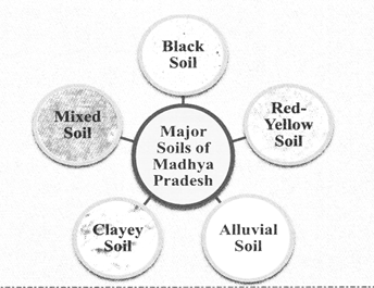
Black Soil
- This soil is composed of basaltic rocks of Deccan Trap. It is also known as Regur soil and local people also called it Kanhar or Bharhi.
- It is found in 47.6% geographical area of the state and it is the largest soil group of Madhya Pradesh.
- In Madhya Pradesh, Black soil is found in Malwa plateau, some parts of Satpura and Narmada valley.
- At the district level, it is found in Mandsaur, Ratlam, Jhabua, Dhar, Khandwa, Khargone, Indore, Dewas, Sehore, Ujjain, Shajapur, Rajgarh, Bhopal, Raisen, Vidisha, Sagar, Damoh, Jabalpur, Narsinghpur, Hoshangabad, Betual, Chhindwara, Shivni, Guna, Shivpuri, Sidhi, and other districts.

- The soil is rich in calcium, magnesium, aluminium, iron, potassium, magnesium carbonate.
- Black soil lacks in nitrogen, phosphorous and organic elements.
- It is acidic in nature.
- The pH value of black soil is 7.5-8.5. It becomes sticky when it is wet and shrinks when it is dried.
- The parent material of the black soil is the weathered material of the igneous basalt rocks. It is black in colour due to the presence of iron and lime in excess.
- As it has excellent capacity for water retention, it is most suitable for the cultivation of cotton, wheat and soybean.
- On the basis of colour and its profile, black soil can further be classified as:-
- Dark Black Soil- This soil is found in abundance in Narmada-Son valley and Malwa plateau of Satpura. It is found around 1.4 lakh hectare of land, out of which 20-60% is clayey soil. It covers 3.5% area of the total area of black soil. The soil mainly consists of iron, lime and it is acidic in nature. In Madhya Pradesh, this soil is highly fertile for the production of wheat, oilseeds and Jowar crops.
- Normal Black Soil -This soil is found in Malwa Plateau, Northern Madhya Pradesh and Nimar region. It covers an area of about 400 lakh acres, which is 37% area of the total area of black soil. This is the most abundant soil type in Madhya Pradesh. This soil does not require much irrigation. Its depth varies from 15 cm to 1 m.
- Layered Black Soil- This soil is mainly found in Chhindwara, Seoni and Betul districts. Its area of coverage in Madhya Pradesh is around 57 lakh acres, out of which 15-30% is clayey soil. It covers 7.1% of area of the total area of black soil. The soil lacks in phosphorus, nitrogen and humus. It is preferred for the cultivation of wheat and rice.
Red-Yellow Soil
- Red soil is the second largest soil group in Madhya Pradesh. It is distributed over 390 lakh acres of the state i.e. 37% of the total land.
- Red soil is found in those areas which receive low rainfall and this soil generally builds up on metamorphic rocks.
- At district level in Madhya Pradesh, this soil is majorly found in Mandla, Katni, Umaria Balaghat, Shahdol and Sidhi districts.
- This soil is composed of Archaean, Dharwar and Gondwana rocks.
- The red colour is because of the oxidation of iron and the yellow colour is because of the hydrolysis of ferric oxide in the soil.
- This soil is generally sandy but due to leaching, very low contents of humus, nitrogen and phosphorus, it has become acidic in nature.
- This soil is rich in iron, aluminium and lime. This soil is porous soil. Its pH varies between 5.5 to 8.5 and hence it is not very fertile.
- In the Baghelkhand region of red-yellow soil, the paddy is cultivated. The main crops grown in this soil group are wheat, rice cotton, potato, rough grains, millets, sugarcane, etc.
- It is mostly found in Bundelkhand and Baghelkhand region of the state.
Alluvial Soil
- This is depositional soil which is composed by the depositions brought by the rivers, It covers about 30 lakh acres area of the state i.e. 3% of the total land area in the state.
- This soil is basic in nature and lacks humus, organic material, nitrogen and phosphorus. This soil is poor in water retention capacity. It is the most fertile soil.
- It is a fined grained fertile soil deposited in river beds or by water flowing over flood plains. Its pH value is above 7.
- This soil is mostly found in North-Western districts of Madhya Pradesh, in the plains of Bundelkhand and Chambal region.
- At district level, it is found in Morena, Bhind, Gwalior and Shivpuri districts of Madhya Pradesh.
- The ratio of sand, silt and clay in this soil is 50:20:30. The soil is suitable for the cultivation of wheat, cotton, sugarcane, rice, jute, barley, cloves, oilseeds, coffee, etc.
Clayey Soil
- This soil is spread by rivers due to flooding in their runoff areas.
- The clayey soil consists of very fine particles of soil. Its water holding capacity is very high. Wet clay soil is very sticky. It contains very little air. The size of soil particles are in clay is less than 0.2mm.
- This soil has been brought to Bhind, Morena, Gwalior (Chambal region) by Chambal and its tributaries.
- This soil is good for crops like wheat, sugarcane and cotton.
- Its pH value is below 5.5. It is suitable for the cultivation of wheat, sugarcane, cotton,cashew, rubber, coconut, coffee, tea, cardamom, pepper, etc.
Mixed Soil
- In different regions of the state, yellow and black soils are found in mixed forms.
- This soil lacks in phosphate, nitrogen, and carbonic compounds and is not so fertile.
- It is mainly used for the cultivation of coarse grains like jowar, barley, bajra, etc.
- It is found in parts of Bundelkhand, Tikamgarh, Rewa and Sidhi.
Other Soils Found in the State
Apart from black, red, yellow, alluvial, laterite and mixed soil loamy and also found in the
state. These are discussed below:
- Loamy Soil- This soil is light in texture and mostly found in the plains and river belts. Fertility level of this soil is medium, contains sand and clay in almost equal proportion.
- Sandy Soil- This soil is mainly composed of green granite rock and parts of stones and sand. It is basically found in the region of Bundelkhnad.
- Sandy soils are mostly suitable for forestation purpose.
- It is also called as light soil.
- Laterite Soil-
This soil is composed by the weathering of the parent rock. It is also known as Bhata. It is rich in aluminum and iron oxides.
- It is acidic in nature because it lacks in potash, phosphoric acid, lime and nitrogen.
- It is composed of the sediments of rivers.
- It covers 4% area of the state. In Madhya Pradesh, it is found in Shivpuri, Gwalior, Chhindwara, Balaghat, Bhind and Morena.
- It is found in about 70% area of Chhindwara and Balaghat districts
Soil Degradation in Madhya Pradesh
Soil Erosion in Madhya Pradesh
Soil degradation and erosion is the major problem in the central India region. The plateau region and steep gradient causes soil erosion and affects the soil fertility of the state.
The soil degradation status in Madhya Pradesh was assessed for its kind, degree, extent and severity and mapped into 55 soil degradation units. It is found that 59.1 per cent of the total geographical area is degraded by various factors and processes. The soil degradation in the state is mainly due to water erosion, specifically loss of top soil and terrain deformation which amounts to 55.66 per cent.
Soil erosion is the removal of the layer of the soil through various environment forces. One of the main factors of soil erosion is deforestation. Soil erosion in Madhya Pradesh is mainly in two regions:
1. Chambal valley Region
2. Balaghat-Satpura Region

Ravine affected areas in Madhya Pradesh
Ravines affected districts in Madhya Pradesh Morena, Gwalior, Shivpuri and Mandsaur.
1. Chambal valley Region
- Land degradation by ravines and gullies is widespread in India, but the most critical zone is the Chambal Valley. The high rate of soil loss due to topsoil erosion, encroachment of gullies, and ravine formation is a severe threat for the overall development for the region
- Gwalior, Morena, Sheopur belt is affected by the gully erosion and ravine formation. Most of the soil erosion in the state is done by the Chambal River. This river causes gully erosion in the state
2. Balaghat-Satpura Region
- Due to excessive rainfall in the Satpura- Balaghat region, the fertility of the soil decreased as the Layer erosion and Leaching increasing the rate of soil erosion.
- Balaghat, Seoni, Chhindwara region is affected by the sheet erosion and leaching.
Summary
Soil
Soil is the thin layer of material covering the earth's surface and is formed from the weathering of rocks. It is made up mainly of mineral particles, organic materials, air, water and living organisms-all of which interact slowly yet constantly.
Physical Properties of Soil
- Soil Colour
- Soil Structure
- Soil Texture
- Soil Porosity
- Soil Density
Chemical properties of Soil
- Soil colloids
- Soil acidity and alkalinity
Biological properties of soil
1. Microorganism- Major microbial groups in soil are bacteria (including actinomycetes), fungi, algae (including cyanobacteria) and protozoa.
2. Other organism-Soil animals, especially, the earthworms and some insects tend to affect the soil favorably through their burrowing and feeding activities which tend to improve aeration and drainage through structural modifications of the soil solum.
Soil Formation Process
There are five key processes by which soil is formed, they are:-
- Leaching
- Eluviation
- Illuviation
- Podszlization
- Gleying
Factors affecting soil formation
- Parent material
- Climate
- Organisms
- Topography
- Time
Soil profile
The soil is the topmost layer of the earth's crust mainly composed of organic minerals and rock \
particles that support life. A soil profile is a vertical cross-section of the soil, made of layers running parallel to the surface. These layers are known as soil horizons.
Soil Horizon
- A soil horizon is a layer parallel to the soil surface whose physical, chemical and biological characteristics differ from the layers above and beneath. Horizons are defined in many cases by obvious physical features, mainly colour and texture. These may be described both in absolute terms (particle size distribution for texture, for instance) and in terms relative to the surrounding material, i.e. 'coarser' or 'sandier' than the horizons above and below.
Soil Degradation
- Soil degradation is the decline in soil condition caused by its improper use or poor management, usually for agricultural, industrial or urban purposes. It is a serious environmental problem. Soils are a fundamental natural resource, and are the basis for all terrestrial life. Avoiding soil degradation is crucial to our well-being.
Soil Erosion
- Soil erosion is a naturally occurring process that affects all landforms. In agriculture, soil erosion refers to the wearing away of a field's topsoil by the natural physical forces of water and wind or through forces associated with farming activities such as tillage.
- Erosion, whether it is by water, wind or tillage, involves three distinct actions- soil detachment, movement and deposition.
Types of Water erosion
- Splash erosion
- Sheet erosion
- Rill erosion
- Gully erosion
- Bank Erosion
Effects of Soil erosion
Soil erosion has adverse effects which are reflected in following points:
- Top soil is eroded which leads to loss of soil fertility and fall in agricultural productivity.
- Flooding and leaching result in loss of mineral nutrient.
- Ground water level is lowered and there is decrease in soil moisture
- Natural vegetation cover dries up and arid land expand
- Frequency and intensity of floods and drought increases.
- Rivers, canals and tanks are silted and
- their water holding capacity decreasing.
Water Logging
- Water logging is the phenomenon of a rising water-table. If the water table rises close to the root systems, it affects the oxygen absorption by the roots and the crop yield.
- As moisture in the soil evaporates transpired salt are left behind and there occurs no leaching, this affects the soil quality. It mainly affects fertile land.
Major Causes of Water logging
- Seepage of water from canals
- Faulty on farm water management
- Lack of adequate drainage
- Interception of natural drainage
Salinity and Alkalinity
- Soil salinity and alkalinity are found in the relatively less rainfall recording areas where the rate of evaporation is generally than the rate of evaporation.
- Also because of over-irrigation, a large area of irrigated land has become saline. The salt lodged in the lower profiles of the soil comes up the surface by capillary action and destroys its fertile.
Desertification
- Desertification can be defined as spread of desert like condition in arid or semi- arid areas due to man's influence or climate change. These areas are characterized by scanty rainfall, sparse vegetation cover and acute scarcity of water. Desert soils suffer maximum erosion by wind.
Causes of Desertification
- The process of desertification is attributed to various causes of which more important are overgrazing, reckless felling of trees, growing population climate change. Other factors that cause desertification include urbanization, climate change, overdrawing of groundwater, deforestation, natural disasters, and tillage practices in agriculture that makes soils more vulnerable to wind erosion.
Measures of controlling desertification
- Intensive tree plantation programme should be initiated.
- Grazing should be controlled and new pastures should be developed
- Mulching of shifting sand dunes should be put in place
- Indiscriminate felling of trees should be banned
- Alternative sources of fuel can reduce the demand for fuel wood
Soil conservation
- Soil conservation is a methodology to maintain soil fertility, prevent soil erosion and exhaustion, and improve the degraded condition of the soil.
Methods of Soil conservation
- Strip Cropping
- Contour Ploughing
- Mulching
- Contour Barriers
- Terrace farming
- Contour Bunding
- Intercropping
- Sand Fences
- Afforestation
- Crop Rotation
Watershed
A watershed is an area of land that feeds all the water running under it and draining off of it into a body of water. It combines with other watersheds to form a network of rivers and streams that progressively drain into larger
water areas.
Watershed Management
Watershed management is the process of guiding and organizing the use of land and other resources in a watershed to provide desired goods and services without adversely affecting soil and water resources.
Types of Watershed
Watersheds are classified depending upon the size, drainage, shape and land use pattern.
- Macro watershed (50,000 Hectare)
- Sub-watershed (10,000 to 50,000 Hectare)
- Mili-watershed (1000 to 10000 Hectare)
- Micro watershed (100 to 1000 Hectare)
- Mini watershed (1-100 Hectare)
Objectives of Watershed Management
The different objectives of watershed management programmes are:
- To control damaging runoff and degradation and thereby conservation of soil and water.
- To manage and utilize the runoff water for useful purpose.
- To protect, conserve and improve me land of watershed for more efficient and sustain production.
- To protect and enhance the water resource originating in the watershed.
- To check soil erosion and to reduce the effect of sediment yield on the watershed.
- To rehabilitate the deteriorating lands.
- To moderate the floods peaks at downstream areas.
- To increase infiltration of rainwater.
Major Soils of Madhya Pradesh
Soils of Madhya Pradesh are broadly classified into five types:
- Black soil
- Red-Yellow soil
- Alluvial soil
- Clayey soil
- Mixed soil
Probable Questions
1. Very Short Questions
- Define Soil?
- Define Humus.
- Define Soil profile?
- Define Soil Horizon?
- What do you mean by soil degradation?
- Name the major soils of Madhya Pradesh
- Define Watershed.
- Define Desertification.
- What are the causes of Desertification?
- Name the regions of alluvial soils in Madhya Pradesh.
- Define Soil Conservation.
- Name those districts of Madhya Pradesh, which have highest ravine affected land. (MPPSC 2015)
2. Short Questions:
- What is Watershed? How can it help in the soil conservation and development of the region?
- What is the importance of soil or why do we need to study soil.
- Briefly describe the problems of Madhya Pradesh soil.
- Describe the main characteristics of soils of Madhya Pradesh. (MPPSC 2018)
3. Long Questions
- Give a detailed account of the types of soils found in Madhya Pradesh.
- Discuss the physical, chemical and biological properties of soil.
- Give a detailed account of soil degradation.
- Give a detailed account of various soil conservation methods.
- Give a detailed account of the soil types, their characteristics and their distribution in Madhya Pradesh. (MPPSC 2016)
- Discuss the problems of soil erosion and soil degradation in Madhya Pradesh and point out their remedies. (MPPSC 2017)
- Give account of areas of Madhya Pradesh which are affected by soil erosion and given measures to prevent soil erosion. . (MPPSC 2018)