-
question_answer1)
Match the following
| List-I (Peaks) | List-II (Range) |
| A. Gurushikhar | 1. Anaimala |
| B. Doddabetta | 2. Aravali |
| C. Anamudi | 3. Nilgiri |
| D. Dhupgarh | 4. Satpura |
A)
A-2 B-1 C-3 D-4 done
clear
B)
A-2 B-3 C-1 D-4 done
clear
C)
A-2 B-4 C-3 D-1 done
clear
D)
A-3 B-2 C-1 D-4 done
clear
View Solution play_arrow
-
question_answer2)
Consider the following statements about our country India:
| I. India has an area of about 3.28 million sq. km. |
| II. India is located in the south-eastern hemisphere. |
| III. The latitudinal extent of India is \[{{8}^{o}}4'N\]and \[37{}^\circ \text{ }6'N\] |
| IV The longitudinal extent of India is \[68{}^\circ 7'E\] and \[97{}^\circ \text{ }25'\text{ }E\] longitudes. |
Of these statements:
A)
Only I is correct done
clear
B)
I, II and III are correct done
clear
C)
Only III and IV are correct done
clear
D)
I, III and IV are correct done
clear
View Solution play_arrow
-
question_answer3)
What would be the influence on the weather conditions when in mid-winter a feeble high pressure develops over the North-Western part of India?
| 1. High and dry winds would blow outward from this high pressure area. |
| 2. The Northern plain would become cold. |
| 3. Scorching winds (locally called loo) would blow during the day time. |
| 4. There would be torrential rains brought by thunderstorms. |
Select the correct answer using the codes given below
A)
1 and 2 done
clear
B)
2 and 3 done
clear
C)
3 and 4 done
clear
D)
All of these done
clear
View Solution play_arrow
-
question_answer4)
Consider the following statements regarding Andaman and Nicobar Islands
| I. enjoys equatorial climate |
| II. This is the only place in India where a volcano is |
| III. This is the only place in India here coral bed is found. |
Which of the statements given above is/arc correct?
A)
I, II and III done
clear
B)
I and II only done
clear
C)
II and III only done
clear
D)
I only done
clear
View Solution play_arrow
-
question_answer5)
Consider the following statements :
| 1. In the coastal regions, the land breeze blows over to the sea during night. |
| 2. In the coastal regions, during night, the air over the sea is warmer than the air over land. |
Which of the statements given above is/are correct?
A)
Only 1 done
clear
B)
Only 2 done
clear
C)
Both 1 and 2 done
clear
D)
Neither 1 nor 2 done
clear
View Solution play_arrow
-
question_answer6)
Which of the following statements is/arc correct?
| 1. Inter-Tropical Convergence Zone is a low pressure belt which forms an important zone of contact over Northern India and Pakistan. |
| 2. Inter-Tropical Convergence Zone invites inflow of winds from different directions. |
Select the correct answer using the code given below:
A)
1 only done
clear
B)
2 only done
clear
C)
Both 1 and 2 done
clear
D)
Neither 1 nor 2 done
clear
View Solution play_arrow
-
question_answer7)
Consider the following statements regarding El Nino effect on Indian Monsoon :
| 1. The surface temperature goes up in (lie Southern Pacific Ocean and there is deficient rainfall in India. |
| 2. The Walker Circulation shifts cast ward from its normal position and reduces monsoon rainfall in India. |
Which of the statements given above is are correct?
A)
` 1 only done
clear
B)
2 only done
clear
C)
Both 1 and 2 done
clear
D)
Neither 1 nor 2 done
clear
View Solution play_arrow
-
question_answer8)
Doddabetta Peak is located in the
A)
Anaimalai done
clear
B)
Mahendragiri done
clear
C)
Nilgiris done
clear
D)
Shevaroys done
clear
View Solution play_arrow
-
question_answer9)
The Himalyas are approximately kilometer long
A)
2000 done
clear
B)
2500 done
clear
C)
3000 done
clear
D)
1500 done
clear
View Solution play_arrow
-
question_answer10)
'Kal Baisakhi' gives rainfall to
A)
Rajasthan done
clear
B)
West Bengal done
clear
C)
Punjab done
clear
D)
Goa done
clear
View Solution play_arrow
-
question_answer11)
The retreating Monsoon gives rainfall to
A)
Gujarat done
clear
B)
Goa done
clear
C)
Tamil Nadu done
clear
D)
Maharashtra done
clear
View Solution play_arrow
-
question_answer12)
Which one of the following is the wettest place in India?
A)
Udhagamandalam done
clear
B)
Mahabaleshwar done
clear
C)
Cherrapunji done
clear
D)
Mawsynram done
clear
View Solution play_arrow
-
question_answer13)
South-West Monsoon reaches Kerala in
A)
End of May done
clear
B)
Mid-June done
clear
C)
Last June done
clear
D)
First week of July done
clear
View Solution play_arrow
-
question_answer14)
South-West monsoon contributes to India's total rainfall up to the extent of
A)
80-90% done
clear
B)
50-55% done
clear
C)
100% done
clear
D)
75% done
clear
View Solution play_arrow
-
question_answer15)
The Deccan trap was formed by the
A)
Dharwar Vulcanicity done
clear
B)
Mesozoic Vulcanicity done
clear
C)
Cretaceous Vulcanicity done
clear
D)
Paleozoic Vulcanicity done
clear
View Solution play_arrow
-
question_answer16)
Which of the following is a part of Eastern coast?
A)
Coromandel coast done
clear
B)
Konkan coast done
clear
C)
Malabar coast done
clear
D)
None of these done
clear
View Solution play_arrow
-
question_answer17)
What is the other name of the highest range in the Western Ghats?
A)
Pir Panjal done
clear
B)
Siwalik range done
clear
C)
Sahyadris done
clear
D)
Namcha Barwa done
clear
View Solution play_arrow
-
question_answer18)
The longest beach of India is situated at
A)
Mumbai done
clear
B)
Chennai done
clear
C)
Mangalore done
clear
D)
Tuticorin done
clear
View Solution play_arrow
-
question_answer19)
What is the name given to the foothills zone of Himalayas?
A)
Inner Himalayas done
clear
B)
Central Himalayas done
clear
C)
Middle Himalayas done
clear
D)
Siwalik done
clear
View Solution play_arrow
-
question_answer20)
In which part of India is Dandakaranaya situated?
A)
Northern done
clear
B)
Eastern done
clear
C)
Central done
clear
D)
Western done
clear
View Solution play_arrow
-
question_answer21)
The Mt. Everest is situated in the region of
A)
Assam Himalayas done
clear
B)
Kumaon Himalayas done
clear
C)
Nepal Himalayas done
clear
D)
Punjab Himalayas done
clear
View Solution play_arrow
-
question_answer22)
The Raman Peak is situated in
A)
Andaman and Nicobar done
clear
B)
Arabian Sea done
clear
C)
Siwaliks done
clear
D)
Zaskar Range done
clear
View Solution play_arrow
-
question_answer23)
The highest peak of south India is
A)
Dodabeta done
clear
B)
Anamudi done
clear
C)
Mahendragire done
clear
D)
Yercaud done
clear
View Solution play_arrow
-
question_answer24)
In which range is the Nathu La Pass situated?
A)
Himalayas done
clear
B)
Sahyadris done
clear
C)
Vindhyas done
clear
D)
Karakoram done
clear
View Solution play_arrow
-
question_answer25)
Consider the following statements and select the correct answer by using the codes given below:
| Assertion [A]: In South India, semiarid steppe climate is found in parts of Karnataka plateau. |
| Reason [R]: It lies in rain shadow area of Sahyadris. |
A)
Both A and R are correct and R is the correct explanation of A. done
clear
B)
Both A and R are correct, but R is not the correct explanation of A. done
clear
C)
A is true, but R is false. done
clear
D)
A is false, but R is true. done
clear
View Solution play_arrow
-
question_answer26)
Match List-I with List-II and select the correct answer from the codes given below:
| List-I (Hill resorts) | List-II (State) |
| A. Dalhousie | 1. Jammu and Kashmir |
| B. Darjeeling | 2. Himachal Pradesh |
| C. Mussoorie | 3. West Bengal |
| D. Pahalgam | 4. Uttarakhand |
A)
A-2 B-4 C-3 D-1 done
clear
B)
A-1 B-3 C-2 D-4 done
clear
C)
A-2 B-3 C-4 D-1 done
clear
D)
A-3 B-1 C-4 D-2 done
clear
View Solution play_arrow
-
question_answer27)
Consider the following statements about south-west monsoon.
| 1. It occurs from June to September. |
| 2. Its direction is north-east to south-west. |
| 3. It gives maximum rainfall as compared to other monsoon. |
| 4. It has no branch. |
Of these statement(s) is/are correct?
A)
1, 2, 3 and 4 done
clear
B)
1 and 3 done
clear
C)
2, 3 and 4 done
clear
D)
2 and 4 done
clear
View Solution play_arrow
-
question_answer28)
Interior of the Deccan plateau receives an annual rainfall of less than 60 cm, mainly because
A)
It is a rain shadow zone/region, done
clear
B)
It is located parallel to wind direction. done
clear
C)
It is away from the coast. done
clear
D)
Rain-bearing clouds are absent. done
clear
View Solution play_arrow
-
question_answer29)
As per geological periods the correct sequence of older of the following is
| 1. Aravali |
| 2. Himalayas |
| 3. Deccan plateau |
| 4. Eastern Ghat |
A)
1, 2, 3, 4 done
clear
B)
4, 3, 2, 1 done
clear
C)
1, 4, 3, 2 done
clear
D)
2, 1, 4, 3 done
clear
View Solution play_arrow
-
question_answer30)
Consider the following statements and select the correct answer by using the codes given below:
| Assertion [A]: India enjoys tropical monsoon climate. |
| Reason [R]: India is located within the tropics. |
Select the correct answer from the following codes:
A)
Both A and R are true and R is the correct explanation of A. done
clear
B)
Both A and R are true, but R is not the correct explanation of A. done
clear
C)
A is true, but R is false. done
clear
D)
A is false, but R is true. done
clear
View Solution play_arrow
-
question_answer31)
Arrange the following mountain ranges from north south order and select the correct answer from the codes
| 1. Dholadhar |
| 2. Ladakh |
| 3. Pirpanjal |
| 4. Zaskar |
A)
2, 4, 1, 3 done
clear
B)
4, 2, 1, 3 done
clear
C)
2, 4, 3, 1 done
clear
D)
4, 2, 3, 1 done
clear
View Solution play_arrow
-
question_answer32)
Which of the following shows the correct geographical spread of the plateaus?
| 1. Chota Nagpur Plateau - much of Jharkhand. West Bengal and adjacent parts of Orissa, Bihar and Chhattisgarh. |
| 2. Deccan Plateau - Vindhyas to the north and flanked by the Eastern and Western Ghats. |
| 3. Malwa Plateau - Rajasthan, Madhya Pradesh and |
| 4. Malwa Plateau - Rajasthan, Maharashtra and Gujarat. |
A)
1 and 2 done
clear
B)
2 and 3 done
clear
C)
3 and 4 done
clear
D)
1, 2 and 3 done
clear
View Solution play_arrow
-
question_answer33)
Match List-I with List-II and select the correct answer from the codes given below:
| List-I (Pass) | List-II (State) |
| A. Shipki La | 1. Arunachal Pradesh |
| B. Niti pass | 2. Himachal Pradesh |
| C. Nathula | 3. Uttarakhand |
| D. Bomdi La | 4. Sikkim |
A)
A-2 B-3 C-4 D-1 done
clear
B)
A-2 B-3 C-1 D-4 done
clear
C)
A-4 B-2 C-1 D-3 done
clear
D)
A-4 B-2 C-3 D-1 done
clear
View Solution play_arrow
-
question_answer34)
Which of the following statements about Nathu La Pass are correct?
| 1. It links Sikkim with Tibet |
| 2. It was the main artery of the ancient Silk Route |
| 3. It was reopened in the year 2006 |
Select the correct answer using the codes given below
A)
1, 2 and 3 done
clear
B)
1 and 2 done
clear
C)
2 and 3 done
clear
D)
1 and 3 done
clear
View Solution play_arrow
-
question_answer35)
Which of the following statements with regard to the expansion of the desert in Rajasthan is/are correct?
| 1. The predominant wind direction in Rajasthan in North-East to South-West, so the tendency for desertification has been more in that direction. |
| 2. The Thar Desert is dominantly a monsoon driven sand desert where wind erosion is a major problem during the summer months. While the Aravali range is a major barrier in the spread of the desert, rampant mining creating cuts in the range is leading to the spread of the desert. |
Select the correct answer using the codes given below
A)
Only 1 done
clear
B)
Only 2 done
clear
C)
Both 1 and 2 done
clear
D)
Neither 1 nor 2 done
clear
View Solution play_arrow
-
question_answer36)
Which of the following statements with regard to rainfall in India is/are correct?
| 1. Most of the rainfall in India is due to the South-West monsoon. |
| 2. In South India, rainfall decreases away from the Eastern Ghats. |
Select the correct answer using the codes given below
A)
Only 1 done
clear
B)
Only 2 done
clear
C)
Both 1 and 2 done
clear
D)
Neither 1 nor 2 done
clear
View Solution play_arrow
-
question_answer37)
Consider the following regions of India
| 1. Western Ghats |
| 2. Aravali Hills |
| 3. Eastern Himalayas |
Which of the above is/are biodiversity hot spot/hot spots?
A)
Only 1 done
clear
B)
1 and 3 done
clear
C)
2 and 3 done
clear
D)
All of the above done
clear
View Solution play_arrow
-
question_answer38)
Match the following
| List-I (Pass) | List-II (State) |
| A. Zoji La Pass | 1. Sikkim |
| B. Bara Lacha Pass | 2. Uttarakhand |
| C. Jelep La Pass | 3. Himachal Pradesh |
| D. Niti Pass | 4. Jammu and Kashmir |
A)
A-4 B-1 C-3 D-2 done
clear
B)
A-2 B-3 C-1 D-4 done
clear
C)
A-4 B-3 C-1 D-2 done
clear
D)
A-2 B-1 C-3 D-4 done
clear
View Solution play_arrow
-
question_answer39)
Consider the following statements. The South-West monsoon originates in India due to
| 1. low pressure in the Punjab plain. |
| 2. high pressure in areas South of India |
| 3. equatorial low being filled up by descending air current. |
| 4. the Himalayas. |
Which of the statements given above arc correct?
A)
1 and 4 done
clear
B)
1 and 2 done
clear
C)
1 and 3 done
clear
D)
2 and 4 done
clear
View Solution play_arrow
-
question_answer40)
Which of the following statements is/are correct?
| I. Mumbai receives more rainfall than Pune because it is located at the windward side of Western Ghats |
| II. Vidarbha region experiences semi-arid climate as it is located in a rain shadow region |
| III. In India monsoon readies Kashmir valley at the last |
Select the correct answer using the code given below:
A)
I, II and III done
clear
B)
I and II only done
clear
C)
II and III only done
clear
D)
I only done
clear
View Solution play_arrow
-
question_answer41)
Which of the following statements regarding south-west monsoon in India is/are correct?
| I. Monsoon reaches the Malabar Coast first |
| II. Rajasthan does not get rainfall from south west monsoon |
| III. South-west monsoon retreats when the permanent wind belts start shifting to the south |
Select the correct answer using the code given below:
A)
I, II and III done
clear
B)
I and II only done
clear
C)
III only done
clear
D)
I and III only done
clear
View Solution play_arrow
-
question_answer42)
Match List-I with List-II and select the correct answer using the code given below the Lists :
| List-I (Mountain pass) | List-II (State) |
| A. Zoji La | 1. Himachal Pradesh |
| B. Lipulekh | 2. Sikkim |
| C. Shipki La | 3. Uttarakhand |
| D. Nathu La | 4. Jammu and Kashmir |
A)
A-2 B-1 C-3 D-4 done
clear
B)
A-2 B-3 C-1 D-4 done
clear
C)
A-4 B-1 C-3 D-2 done
clear
D)
A-4 B-3 C-1 D-2 done
clear
View Solution play_arrow
-
question_answer43)
Match List I with List II and select the correct answer using the code given below the Lists:
| List-I (Himalayan Peak) | List-II (State) |
| A. K2 | 1. Uttarakhand |
| B. Nanda Devi | 2. Jammu & Kashmir |
| C. Tara Pahar | 3. Sikkim |
| D. Kanchenjunga | 4. Himachal Pradesh |
A)
A-2 B-4 C-1 D-3 done
clear
B)
A-2 B-1 C-4 D-3 done
clear
C)
A-3 B-1 C-4 D-2 done
clear
D)
A-3 B-4 C-1 D-2 done
clear
View Solution play_arrow
-
question_answer44)
Which one of the following islands is of volcanic origin? [CDS 2016-I]
A)
Reunion Island done
clear
B)
Andaman & Nicobar Island done
clear
C)
Lakshadweep Island done
clear
D)
Maldives done
clear
View Solution play_arrow
-
question_answer45)
Pir Panjal Range in the Himalayas is a part of: [CDS 2016-I]
A)
Shiwalik done
clear
B)
Trans Himalaya done
clear
C)
Central Himalaya done
clear
D)
Lesser Himalaya done
clear
View Solution play_arrow
-
question_answer46)
Which of the following are the major factors responsible for the monsoon type of climate in India? [CDS 2016-II]
| 1. Location |
| 2. Thermal contrast |
| 3. Upper air circulation |
| 4. The Himalayan Mountains |
Select the correct answer using the code given below.
A)
1 and 4 only done
clear
B)
1, 2, 3 and 4 done
clear
C)
2, 3 and 4 only done
clear
D)
1, 2 and 3 only done
clear
View Solution play_arrow
-
question_answer47)
Match List-I with List-II and select the correct answer using the code given below the Lists: [CDS 2016-II]
| List-I (City) | List-II (Earthquake zone) |
| A. Kolkata | 1. Zone V |
| B. Guwahati | 2. Zone IV |
| C. Delhi | 3. Zone III |
| D. Chennai | 4. Zone II |
A)
A-3 B-2 C-1 D-4 done
clear
B)
A-3 B-1 C-2 D-4 done
clear
C)
A-4 B-1 C-2 D-3 done
clear
D)
A-4 B-2 C-1 D-3 done
clear
View Solution play_arrow
-
question_answer48)
Which one of the following is correct? The Palghat Gap serves inland communications from [2007-II]
A)
Madurai to Thiruvananthapuram done
clear
B)
Chennai to Kochi done
clear
C)
Pune to Mumbai done
clear
D)
Bengaluru to Mangalore done
clear
View Solution play_arrow
-
question_answer49)
Which of the following divides India into northern and Southern parts? [2008-]
A)
Equator done
clear
B)
Tropic of cancer done
clear
C)
Tropic of Capricorn done
clear
D)
Arctic Circle done
clear
View Solution play_arrow
-
question_answer50)
Consider the following statements [2008-] The South-West monsoon originates in India due to
| 1. low pressure in the Punjab plain. |
| 2. high pressure in areas South of India equatorial low being filled up by descending air current |
| 4. the Himalayas. |
Which of the statements given above are correct?
A)
1 and 4 done
clear
B)
1 and 2 done
clear
C)
1 and 3 done
clear
D)
2 and 4 done
clear
View Solution play_arrow
-
question_answer51)
Which waterway separates India from Sri Lanka? [2008-I]
A)
\[{{8}^{o}}\] Channel done
clear
B)
Palk Strait done
clear
C)
\[{{10}^{o}}\]Channel done
clear
D)
Andaman Sea done
clear
View Solution play_arrow
-
question_answer52)
Which one of the following peaks is the highest? [2008-I]
A)
Nanda Devi done
clear
B)
Kanchenjunga done
clear
C)
Godwin Austin done
clear
D)
Nanga Parbat done
clear
View Solution play_arrow
-
question_answer53)
With which one of the following countries, India shares maximum length of the border? [2008-I]
A)
Bangladesh done
clear
B)
Pakistan done
clear
C)
China done
clear
D)
Nepal done
clear
View Solution play_arrow
-
question_answer54)
The hill station of Coonoor is located in which one of following states? [2008-II]
A)
Karnataka done
clear
B)
Andhra Pradesh done
clear
C)
Kerala done
clear
D)
Tamil Nadu done
clear
View Solution play_arrow
-
question_answer55)
Which one of the following is the oldest mountain rang in India? [2009-I]
A)
Himalayas done
clear
B)
Aravalli done
clear
C)
Satpura done
clear
D)
Nilgiri done
clear
View Solution play_arrow
-
question_answer56)
Which one of the following longitudes determines the Indian standard time? [2009-I]
A)
\[85.5{}^\circ \text{ }E\] done
clear
B)
\[86.5{}^\circ \text{ }E\] done
clear
C)
\[84.5{}^\circ \text{ }E\] done
clear
D)
\[82.5{}^\circ \text{ }E\] done
clear
View Solution play_arrow
-
question_answer57)
In which one of the following islands of India is an active volcano found? [2009-I]
A)
Car Nicobar Island done
clear
B)
Nancowry Island done
clear
C)
Barren Island done
clear
D)
May a Bunder Island done
clear
View Solution play_arrow
-
question_answer58)
Consider the following statements
| 1. In the month of July, the Inter Tropical Convergence Zone is located in the Indo Gangetic plain. |
| 2. Northen Inter Tropical Convergence Zone is the zone of clouds and heavy rainfall. |
Which of the statement given above is/are correct? [2009-II]
A)
Only 1 done
clear
B)
Only 2 done
clear
C)
Both 1 and 2 done
clear
D)
Neither 1 nor 2 done
clear
View Solution play_arrow
-
question_answer59)
The hill range that separates the State of Manipur from Bile-State of Nagaland is known as [2009-II]
A)
Arakan hills done
clear
B)
Patkai hills done
clear
C)
Barail hills done
clear
D)
Manipur lulls done
clear
View Solution play_arrow
-
question_answer60)
Which one of the following is not associated with Monsoon climate in India? [2010-I]
A)
El Nino temporary warm currents done
clear
B)
South-equatorial warm currents of Indian Ocean done
clear
C)
Western disturbances done
clear
D)
Cyclones of Bay of Bengal done
clear
View Solution play_arrow
-
question_answer61)
Which one of the following statements is not correct regarding the Himalayas? [2010-II]
A)
Himalayas have nappe and recumbent folds done
clear
B)
Himalayas rose up from the Tethys Sea done
clear
C)
Himalayas contain three mountain ranges-Siwaliks, Great Himalayas and kunlun Ranges done
clear
D)
The orogeny took place in the Tertiary Era done
clear
View Solution play_arrow
-
question_answer62)
Consider the following places of Kashmir region
| (1) Srinagar |
| (2) Gilgit |
| (3) Kargil |
| (4) Banihal |
Arrange the above place from North to South using the code given below [2010-II]
A)
1, 2, 3, 4 done
clear
B)
4, 3, 2, 1 done
clear
C)
2, 3, 1, 4 done
clear
D)
2, 1, 3, 4 done
clear
View Solution play_arrow
-
question_answer63)
During the Indian monsoon season [2010-II]
A)
the Westerly jet stream alone exists in the Indian region done
clear
B)
the Easterly jet stream alone exists in the Indian region done
clear
C)
both Westerly and Easterly jet streams exist in the Indian region done
clear
D)
both Westerly and Easterly jet streams disappear done
clear
View Solution play_arrow
-
question_answer64)
What is the characteristic feature of Narmada Valley? [2010-II]
A)
Volcanic origin done
clear
B)
Structural origin done
clear
C)
Glacial origin done
clear
D)
Aeolian origin done
clear
View Solution play_arrow
-
question_answer65)
The rainfall distribution pattern over the Ganga basin decreases from the [2011-11
A)
West to East and North to South done
clear
B)
East to West and North to South done
clear
C)
West to East and South to North done
clear
D)
East to West and South to North done
clear
View Solution play_arrow
-
question_answer66)
'El Nino' associated with the formation of the South West Monsoon of India is [2011 -II]
A)
an abnormally w arm ocean current done
clear
B)
a periodic warm air-mass done
clear
C)
a periodic warm wind done
clear
D)
a periodic low pressure centre done
clear
View Solution play_arrow
-
question_answer67)
Duncan Passage is located between [2012-I]
A)
South and little Andaman done
clear
B)
Little and Great Nicobar done
clear
C)
North and Middle Andaman done
clear
D)
Middle and South Andaman done
clear
View Solution play_arrow
-
question_answer68)
Match the following [2012-11]
| List-I (Hill Station) | List-II (Location in Map) |
| A. Dharamsala |  |
| B. Almora |
| C. Nainital |
| D. Darjeeling |
A)
A-1 B-2 C-3 D-4 done
clear
B)
A-1 B-3 C-2 D-4 done
clear
C)
A-2 B-1 C-4 D-3 done
clear
D)
A-2 B-4 C-1 D-3 done
clear
View Solution play_arrow
-
question_answer69)
The Karewas of Kashmir refers to which among the following types of deposits? [2013-I]
A)
Aeolian and glacial done
clear
B)
Fluvial done
clear
C)
Lacustrine done
clear
D)
Volcanic done
clear
View Solution play_arrow
-
question_answer70)
Veliconda group of low lulls is a structural part of [2014-II]
A)
Nilgiri Hills done
clear
B)
Western Ghats done
clear
C)
Eastern Ghats. done
clear
D)
Cardamom Hills done
clear
View Solution play_arrow
-
question_answer71)
Which one of the following is depositional landform? [2014-I]
A)
Stalagmite done
clear
B)
Lapis done
clear
C)
Sinkhole done
clear
D)
Cave done
clear
View Solution play_arrow
-
question_answer72)
What would be the influence on the weather conditions when in mid-winter a feeble high pressure develops over North-Western part of India? [2014-I]
| 1. High and dry winds would blow outward from this high pressure area. |
| 2. The Northern plain would become cold. |
| 3. Scorching winds (locally called loo) would blow during the day time. |
| 4. There would be torrential rains brought by thunderstorms. |
Select the correct answer using the codes given below
A)
1 and 2 done
clear
B)
2 and 3 done
clear
C)
3 and 4 done
clear
D)
All of these done
clear
View Solution play_arrow
-
question_answer73)
Which one of the following would have happened if the Himalayas did not exist? [2014-II]
A)
Monsoon rains would have taken place in winter months done
clear
B)
Coastal India would have experienced Mediterranean done
clear
C)
North Indian plain would have been much cooler in winter done
clear
D)
North western part of India would have experienced humid condition done
clear
View Solution play_arrow
-
question_answer74)
Match List I with List II and select the correct answer using the code given below the Lists: [2014-II]
| List-I (Hill range of Central India) | List-II (II) |
| A. Satpura | 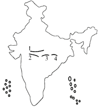 |
| B. Mahadeo |
| C. Vindhya |
| D. Maikala |
A)
A-4 B-3 C-1 D-2 done
clear
B)
A-4 B-1 C-3 D-2 done
clear
C)
A-2 B-1 C-3 D-4 done
clear
D)
A-2 B-3 C-1 D-4 done
clear
View Solution play_arrow
-
question_answer75)
DIRECTION: The following questions consist of two statements, Statement I and Statement II. You are to exam me these two statements carefully and select the answers to these questions using the code given below: [2014-II]
| Statement I: India's off shore and deep sea fish catch is very poor considering the marine potential. |
| Statement II: Indian coast does not have many gulfs, bays, estuaries and backwaters. [2015-I] |
A)
Both the statements are individually true and Statement II is the correct explanation of Statement I done
clear
B)
Both the statements are individually true but Statement II is not the correct explanation of Statement I done
clear
C)
Statement I is true but Statement II is false done
clear
D)
Statement I is false but Statement II is true done
clear
View Solution play_arrow
-
question_answer76)
Consider the following statements with regard to cold waves in winter season in northern India: [2015-I]
| 1. There is lack of maritime influence. |
| 2. Northern India is nearer to the Himalayan region. |
| 3. Air mass comes from Polar Regions to northern India. |
Which of the statements given above is/are correct?
A)
1 only done
clear
B)
2 and 3 done
clear
C)
1 and 3 done
clear
D)
1 and 2 done
clear
View Solution play_arrow
-
question_answer77)
In India, glacial terraces known as 'Karewas' are found in [NDA/NA 2016-I]
A)
Sapt Kosi Valley done
clear
B)
Jhelum Valley done
clear
C)
Alakananda Valley done
clear
D)
Teesta Valley done
clear
View Solution play_arrow
-
question_answer78)
Consider the following statements: [NDA/NA 2016-I]
| 1. Rajmahal highlands consist of lava flow deposits. |
| 2. Bundelkhand gneiss belong to the oldest Archaean rocks of India. |
Which of the statements given above is/are correct?
A)
1 only done
clear
B)
2 only done
clear
C)
Both 1 and 2 done
clear
D)
Neither 1 nor 2 done
clear
View Solution play_arrow
-
question_answer79)
Deserts, fertile plains and moderately forested mountains are the characteristic features of which one of the following regions of India? [NDA/NA 2016-]
A)
South-Western border along Arabian Sea done
clear
B)
Coromandel Coast done
clear
C)
North-Eastern Frontier done
clear
D)
North-Western India done
clear
View Solution play_arrow
-
question_answer80)
In Thar region, the shifting sand dunes are locally known as [NDA/NA 2016-I]
A)
Dhrian done
clear
B)
Daurs done
clear
C)
Dhoros done
clear
D)
Dhaya done
clear
View Solution play_arrow
-
question_answer81)
Jelep La pass is located in [NDA/NA 2016-I]
A)
Punjab Himalaya done
clear
B)
Sikkim Himalaya done
clear
C)
Kumaon Himalaya done
clear
D)
Kashmir Himalaya done
clear
View Solution play_arrow
-
question_answer82)
DIRECTIONS: The following six (6) items consist of two statements, Statement I and Statement II. You are to examine these two statements carefully and select the answers to these items using the code given below: [NDA/NA 2014-II]
| Statement I: The Kullu Valley in Himachal Pradesh receives copious snowfall during winter. |
| Statement II: The Kullu Valley receives moisture-bearing wind of the Western Disturbances during winter. |
A)
Both the statements are individually true and Statement I is the correct explanation of Statement I done
clear
B)
Both the statements are individually true but Statement II is not the correct explanation of Statement I done
clear
C)
Statement I is true but Statement II is false done
clear
D)
Statement I is false but Statement II is true done
clear
View Solution play_arrow
-
question_answer83)
Which one among the following is the coral group of island of India? [NDA/NA 2014]
A)
Andaman done
clear
B)
Nicobar done
clear
C)
Minicoy done
clear
D)
Lakshadweep done
clear
View Solution play_arrow
-
question_answer84)
Consider the following statements: [NDA/NA 2014-4]
| 1. Crystallization is a form of mechanical weathering. |
| 2. Hydration causes granular disintegration. |
| 3. Frost action is synonymous with freeze-thaw action. |
Which of the statements given above are correct?
A)
1 and 2 only done
clear
B)
2 and 3 only done
clear
C)
1 and 3 only done
clear
D)
1, 2 and 3 done
clear
View Solution play_arrow
-
question_answer85)
Considering the locations of mountains in India, which one among the following is in right sequence from south north? [NDA/NA 2014-I]
A)
Doddabetta, Kailash, Dhaulagiri, Vindhyachal done
clear
B)
Doddabetta, Vindhyaclial, Dhaulagiri, Kailash done
clear
C)
Dhaulagiri, Kailash, Doddabetta, Vindhyachal done
clear
D)
Dhaulagiri, Vindhyachal Doddabetta, Kailash done
clear
View Solution play_arrow
-
question_answer86)
Match List I with List II and select the correct answer using the code given below the lists: [NDA/NA2013-II]
| List-I (Land form of peninsular India) | List-II (Predominant rock) |
| A. Marwar upland | 1. Quartzites Shales, Schists |
| B. Bundelkhand upland | 2. Sandstone, Shale, Limestone |
| C. Meghalaya upland | 3. Granite and Gneiss |
| D. Maharashtra plateau | 4. Basalt |
A)
A-2 B-3 C-1 D-4 done
clear
B)
A-2 B-1 C-3 D-4 done
clear
C)
A-4 B-3 C-1 D-2 done
clear
D)
A-4 B-1 C-3 D-2 done
clear
View Solution play_arrow
-
question_answer87)
Cardamom hills lie along the border of [UP-PCS 2008]
A)
Karnataka and Tamil Nadu done
clear
B)
Karnataka and Kerala done
clear
C)
Kerala and Tamil Nadu done
clear
D)
Tamil Nadu and Andhra Pradesh done
clear
View Solution play_arrow
-
question_answer88)
In which Slate of India. Fulhar Lake is situated?[UP-PCS 2009-I]
A)
Madhya Pradesh done
clear
B)
Uttarakhand done
clear
C)
Uttar Pradesh done
clear
D)
Bihar done
clear
View Solution play_arrow
-
question_answer89)
Which is the highest peak in Andaman and Nicobar Islands? [UP-PCS 2009]
A)
Saddle Peak done
clear
B)
Mount Thuiller done
clear
C)
Mount Diavolo done
clear
D)
Mount Key ale done
clear
View Solution play_arrow
-
question_answer90)
Which of the following rivers flows through a "rift' valley? [UP-PCS 2010]
A)
Ganga done
clear
B)
Brahmaputra done
clear
C)
Narmada done
clear
D)
Krishna done
clear
View Solution play_arrow
-
question_answer91)
If the Sun rises at Tirap in Arunachal Pradesh al 5.00 am (1ST), then what time (1ST) the Sun will rise in Kandia in Gujarat? [UP-PCS 2010-I]
A)
About 5.30 a.m. done
clear
B)
About 6.00 a.m. done
clear
C)
About 7.00 a.m. done
clear
D)
About 7.30 a.m. done
clear
View Solution play_arrow
-
question_answer92)
Which one of the following does NOT lie in Maharashtra? [UP-PCS 2011]
A)
Balaghat Range done
clear
B)
Harishchandra Range done
clear
C)
Mandav Hills done
clear
D)
Satmala Hills done
clear
View Solution play_arrow
-
question_answer93)
Which of the following wetlands are designated as Ramsar sites? [UP-PCS 2013]
| 1. Chilka Lake |
| 2. Loktak |
| 3. Keoladeo |
| 4. Wullar Lake |
Select the Correct answer from the code given below;
A)
1 and 2 only done
clear
B)
2 and 3 only done
clear
C)
1, 2 and 3 done
clear
D)
All done
clear
View Solution play_arrow
-
question_answer94)
Which one of the following coasts of India is located between Krishna delta and Cape Comorin?
A)
Coromandel Coast done
clear
B)
North Circar done
clear
C)
Malabar Coast done
clear
D)
Konkan Coast done
clear
View Solution play_arrow
-
question_answer95)
In which of the following areas of India goo-thermal energy sources have not been found? [UP PCS (M) 2016]
A)
Godavari Delta done
clear
B)
Ganga Delta done
clear
C)
Himalayas done
clear
D)
West Coast done
clear
View Solution play_arrow
-
question_answer96)
Which amongst the following States gets the highest average annual rainfall? [UP PCS (M) 2016]
A)
Arunachal Pradesh done
clear
B)
Sikkim done
clear
C)
Kerala done
clear
D)
Jammu & Kashmir done
clear
View Solution play_arrow
-
question_answer97)
Rohtang pass connects the valleys of- [Bihar J. Service 2016]
A)
Bhagirathi and Alaknanda done
clear
B)
Kali and Dholi done
clear
C)
Kullu and Spill done
clear
D)
Jhelam and Ravi done
clear
View Solution play_arrow
-
question_answer98)
The basic reason of winter rainfall in northwestern part of India is- [Bihar J. Sen ice 2016]
A)
south-west monsoon done
clear
B)
trade wind done
clear
C)
retreating of monsoon done
clear
D)
western disturbances done
clear
View Solution play_arrow
-
question_answer99)
The maximum rainfall in India is received from- [UK-PSC (F) 2015]
A)
South-West monsoon done
clear
B)
Retreating monsoon done
clear
C)
North-Eastern monsoon done
clear
D)
Cyclones done
clear
View Solution play_arrow
-
question_answer100)
Himalayan mountain system originated out of the following geosynclines-[UK-PSC (F) 2015]
A)
Ural geosyncline done
clear
B)
Rocky geosyncline done
clear
C)
Tethys geosynclines done
clear
D)
None of the above done
clear
View Solution play_arrow
-
question_answer101)
In how many districts of Uttarakhand the Greater Himalaya is spread over? [UK-PSC (F) 2015]
A)
3 districts done
clear
B)
4 districts done
clear
C)
6 districts done
clear
D)
5 districts done
clear
View Solution play_arrow
-
question_answer102)
Which among the following rock systems in India is also known as storehouse of minerals?
A)
The Cudappah system done
clear
B)
Archaean Rock system done
clear
C)
Dharwar system done
clear
D)
The Vindhyan System done
clear
View Solution play_arrow
-
question_answer103)
Consider the following statements-
| 1. Himalayan mountain chain was part of Laurasia or Angaral and geological divisions. |
| 2. Peninsular India was part of Gondwanaland of Geological divisions. |
Select the correct answer from the following codes:
A)
Only 1 done
clear
B)
Only 2 done
clear
C)
Both 1 and 2 done
clear
D)
Neither 1 nor 2 done
clear
View Solution play_arrow
-
question_answer104)
Which one of the following mountain ranges is spread over only one stale in India? [MP-PSC 2017]
A)
Aravali done
clear
B)
Salpura done
clear
C)
Ajanta done
clear
D)
Sahyadri done
clear
View Solution play_arrow
-
question_answer105)
What is Kayal? [MP- PSC 2017]
A)
Terai-Plain done
clear
B)
Ganges Delta done
clear
C)
Regur of Deccan Plateau done
clear
D)
Lagoon of Kerala done
clear
View Solution play_arrow
-
question_answer106)
Which of die following pairs is not correctly matched? [MP- PSC 2017]
A)
Lipulekh - Uttarakhand done
clear
B)
Nathu La - Arunachal Pradesh done
clear
C)
Rohtang - Himachal Pradesh done
clear
D)
Palghat - Kerala done
clear
View Solution play_arrow
-
question_answer107)
With reference to the wetlands of India, consider the following statements-
| 1. The Country's total geographical area under the category of wetlands is recorded more in Gujarat as compared to other states. |
| 2. In India, the total geographical area of coastal wetlands is larger than that of inland wetlands. |
Which of the statements given above is/are correct?
A)
1 only done
clear
B)
2 only done
clear
C)
Both 1 and 2 done
clear
D)
Neither 1 nor 2 done
clear
View Solution play_arrow
-
question_answer108)
Consider the following statements-
| 1. Zojila Pass in Pir Panzal range connects Jammu and Srinagar |
| 2. Banihal Pass connects Srinagar to Drass and Kargil. |
Which of the above statements) is/are correct?
A)
1 only done
clear
B)
2 only done
clear
C)
Both 1 and 2 done
clear
D)
None of the above done
clear
View Solution play_arrow
-
question_answer109)
Match the following-
| Mountain Pass | State |
| A. Zoji La | 1. Himachal Pradesh |
| B. Lipulekh | 2. Sikkim |
| C. Shipkila | 3. Uttarakhand |
| D. Nathu La | 4. Jammu-Kashmir |
Select the correct answer using the codes given below the lists-
A)
A-2 B-1 C-3 D-4 done
clear
B)
A-2 B-3 C-1 D-4 done
clear
C)
A-4 B-1 C-3 D-2 done
clear
D)
A-4 B-3 C-1 D-2 done
clear
View Solution play_arrow
-
question_answer110)
Which of the following landforms occupy the North- Western parts of Bihar State? [BPSC (PT) 2017]
A)
Someshwar Hilly Range done
clear
B)
Kaimur Plateau done
clear
C)
Nawada Hilly Region done
clear
D)
Rajgir Hilly Region done
clear
E)
(e) None of the above/More than one of the above done
clear
View Solution play_arrow
-
question_answer111)
What is the height of parasnath Hill? [Jharkh-PSC 2016]
A)
1600 Meter done
clear
B)
1565 Meter done
clear
C)
1365 Meter done
clear
D)
1260 Meter done
clear
View Solution play_arrow
-
question_answer112)
Arrange the following from North to South-
| 1. Coco channel |
| 2. Little Andaman |
| 3. Narcondam Island |
| 4. Barren Island |
A)
1, 2, 3, 4 done
clear
B)
1, 3, 4, 2 done
clear
C)
1, 2, 3, 4 done
clear
D)
2, 1, 3, 4 done
clear
View Solution play_arrow
-
question_answer113)
Which one of die following regions separates the Great Plains of North India from Ac plateaus and coastal plains of the Deccan?
A)
Central Highlands done
clear
B)
Western Himalayas done
clear
C)
Eastern Himalayas done
clear
D)
Western Arid Plains done
clear
View Solution play_arrow
-
question_answer114)
Which one of the following regions has been classified as the 'Western Dry Region' by the Planning Commission? [UGC-II(Geog) 2016]
A)
North Bihar Dry Region done
clear
B)
Rajasthan Dry Region done
clear
C)
NEFA Region done
clear
D)
West Bengal Duars done
clear
View Solution play_arrow
-
question_answer115)
Given below are two statements, one labelled as Assertion and other labelled as Reason (R). Select your answer from the codes given below- [UGC-II (Geog) 2016]
| Assertion [A]: The Tarai region represents a marsh landscapes |
| Reason [R]: The Tarai region is a zone of seepage where the fine sand, silt and clay are deposited the emerging streams. |
A)
Both A and R are true and R is the correct explanation of A done
clear
B)
Both A and R are true, but R is not the correct explanation of A done
clear
C)
A is true, but R is false. done
clear
D)
A is false, but R is true. done
clear
View Solution play_arrow
-
question_answer116)
Which one of the following statements is correct? [UGC-II (Geog) 2016]
A)
One Himalayas were formed due to faulting of the earth's crust done
clear
B)
Himalayas are the oldest mountains done
clear
C)
Himalayas belong to the Caledonian mountain system done
clear
D)
Himalayas have risen from the Tethys Sea when the sea got compressed, done
clear
View Solution play_arrow
-
question_answer117)
What are Kingri-Bingri, Neeti-Mana? [UK-PSC 2016]
A)
Passes done
clear
B)
Rivers done
clear
C)
Mountains done
clear
D)
Religious places done
clear
View Solution play_arrow
-
question_answer118)
Where in Uttarakhand is the Kaliasaur Landslide Zonel situated? [UK-PSC 2016]
A)
Between Chamba and Narendra Nagar done
clear
B)
Between Kotdwara and Dogadda done
clear
C)
Between Agastyamuni and Guptkashi done
clear
D)
Between Srinagar and Rudra Prayag done
clear
View Solution play_arrow
-
question_answer119)
As per Koppen's classification of climate, which one of the following is the suitable description of North-East India including North Bengal? [UK-PSC 2016]
A)
Tropical monsoon rainforest (Amw) done
clear
B)
Sub-tropical monsoon rainforest (Am) done
clear
C)
Tropical wet and dry climate (Monsoon Savannah) (Aw) done
clear
D)
Humid sub-tropical climate with dry winter (Cwg) done
clear
View Solution play_arrow
-
question_answer120)
Which of the following passes is in Arunachal Pradesh?
A)
Bomdila Pass done
clear
B)
Rohtang Pass done
clear
C)
Bara Lachan Pass done
clear
D)
Shipki La Pass done
clear
View Solution play_arrow
-
question_answer121)
Among the following which mountain range is the oldest in India? [Chhatis-PSC 2016]
A)
Nilgiri done
clear
B)
Aravali done
clear
C)
Satpura done
clear
D)
Western Ghat done
clear
View Solution play_arrow
-
question_answer122)
Which of the following regions is NOT affected much by the Arabian Sea branch of Monsoon? [Chhatis- PSC 2016]
A)
The Western Ghat done
clear
B)
Deccan Plateau done
clear
C)
Madhya Pradesh done
clear
D)
Chhattisgarh Basin done
clear
View Solution play_arrow
-
question_answer123)
India has................. seismic zones.
A)
3 done
clear
B)
4 done
clear
C)
5 done
clear
D)
6 done
clear
View Solution play_arrow
-
question_answer124)
Consider the following statements:
| 1. In India, the Himalayas are spread over five States only. |
| 2. Western Ghats are spread over five States only. |
| 3. Pulicat Lake is spread over two States only. |
Which of the statements given above is/are correct?
A)
1 and 2 only done
clear
B)
3 only done
clear
C)
2 and 3 only done
clear
D)
1 and 3 only done
clear
View Solution play_arrow
-
question_answer125)
If you travel by road from Kohima to Koltayam, what is the minimum number of States within India through which you can travel, including the origin and the destination?
A)
6 done
clear
B)
7 done
clear
C)
8 done
clear
D)
9 done
clear
View Solution play_arrow


