-
question_answer1)
Which one of the following is a temperate desert?
A)
Arabian desert done
clear
B)
Atacama desert done
clear
C)
Kalahari desert done
clear
D)
Patagonia n desert done
clear
View Solution play_arrow
-
question_answer2)
Which one of the following is not a tropical desert?
A)
Atacama done
clear
B)
Arabia done
clear
C)
Gobi done
clear
D)
Kalahari done
clear
View Solution play_arrow
-
question_answer3)
Bhabar is an example of
A)
Pan plane done
clear
B)
Piedmont plain done
clear
C)
Till plain done
clear
D)
Deltaic plain done
clear
View Solution play_arrow
-
question_answer4)
Where is the Blind valley found?
A)
River valley region done
clear
B)
Arid region done
clear
C)
Karst region done
clear
D)
Glacier region done
clear
View Solution play_arrow
-
question_answer5)
Rift valley is formed by
A)
Earthquake done
clear
B)
Folding done
clear
C)
Faulting done
clear
D)
All of these done
clear
View Solution play_arrow
-
question_answer6)
U-shaped valley develops in
A)
Karst region done
clear
B)
Glacial region done
clear
C)
Desert region done
clear
D)
All of these done
clear
View Solution play_arrow
-
question_answer7)
Landscapes, developed due to Rejuvenation activity are called
A)
Polycyclic landscapes done
clear
B)
Monocyclic landscape done
clear
C)
Mixed landscape done
clear
D)
Compound landscape done
clear
View Solution play_arrow
-
question_answer8)
Which of the following land forms is not formed by wind action?
A)
Stone Latice done
clear
B)
Mushroom or Gara done
clear
C)
Sandbars done
clear
D)
Inselberg done
clear
View Solution play_arrow
-
question_answer9)
Karst landforms are made by
A)
waves in coastal areas done
clear
B)
wind in the semi-arid regions done
clear
C)
water in limestone regions done
clear
D)
glaciers in the coasal regions done
clear
View Solution play_arrow
-
question_answer10)
Hanging valleys are associated with
A)
winds action done
clear
B)
glacial action done
clear
C)
wave action done
clear
D)
river action done
clear
View Solution play_arrow
-
question_answer11)
Bays and gulfs are usually made by the erosional work of
A)
waves done
clear
B)
large streams done
clear
C)
coastal glaciers done
clear
D)
underground water done
clear
View Solution play_arrow
-
question_answer12)
Consider the following statements and select the correct answer from the codes given below:
| Assertion [A]: Aridity is the distinctive characteristic of the deserts. |
| Reason [R]: They receive low rainfall and have high evaporation. |
A)
Both A and R are true and R is the correct explanation of A. done
clear
B)
Both A and R are true, but R is not the correct explanation of A. done
clear
C)
A is true, but R is false. done
clear
D)
A is false, but R is true. done
clear
View Solution play_arrow
-
question_answer13)
Match List-I and List-II and select the correct answer from the codes given below:
| List-I (Processes) | List-II (Land forms) |
| A. Permafrost | 1. Flood plain |
| B. Diastrophism | 2. Pingo |
| C. Running water | 3. Stack |
| D. Sea waves | 4. Horst |
A)
A-2 B-4 C-1 D-3 done
clear
B)
A-2 B-1 C-4 D-3 done
clear
C)
A-1 B-2 C-2 D-4 done
clear
D)
A-4 B-3 C-2 D-1 done
clear
View Solution play_arrow
-
question_answer14)
Select the correct chronological order of the following organic cycles from the codes given below:
| 1. Alpine |
| 2. Torridonian |
| 3. Caledonian |
| 4. Hercynian |
A)
2, 4, 1, 3 done
clear
B)
2, 3, 4, 1 done
clear
C)
1, 3, 4, 2 done
clear
D)
4, 3, 2, 1 done
clear
View Solution play_arrow
-
question_answer15)
Consider the following statements and select the correct answer from codes given below:
| Assertion [A]: Tropical areas get more insolation than the temperate area. |
| Reason [R]: Tropical areas have larger length of day than the temperate areas. |
A)
Both A and R are true and R is the correct explanation of A. done
clear
B)
Both A and R are true, but R is not the correct explanation of A. done
clear
C)
A is true, but R is false. done
clear
D)
A is false, but R is true. done
clear
View Solution play_arrow
-
question_answer16)
Match List-I with List-II and choose the correct answer with the help of the codes:
| List-I (Land forms) | List-II (Agents of formation) |
| A. Faults | 1. Glacial activity |
| B. Flood plains | 2. Fluvial effects |
| C. Coral reefs | 3. Organic activity |
| D. Moraines | 4. Earth movement |
A)
A-1 B-3 C-2 D-4 done
clear
B)
A-4 B-2 C-3 D-1 done
clear
C)
A-3 B-1 C-4 D-2 done
clear
D)
A-2 B-3 C-1 D-4 done
clear
View Solution play_arrow
-
question_answer17)
Match List-I with List-II and select the correct answer using the codes given below:
| List-I (Soils) | List-II (Climatic region) |
| A. Podzol | 1. Temperate grass lands |
| B. Chemozem | 2. Cool temperate |
| C. Spodsols | 3. Hot and humid |
| D. Laterite | 4. Humid cool temperate |
A)
A-2 B-1 C-4 D-3 done
clear
B)
A-3 B-4 C-2 D-1 done
clear
C)
A-2 B-3 C-4 D-1 done
clear
D)
A-4 B-1 C-3 D-2 done
clear
View Solution play_arrow
-
question_answer18)
Match the following
| List-I | List-II |
| A. Isobars | 1. Temperature |
| B. Isohyets | 2. Pressure |
| C. Isotherms | 3. Rainfall |
| D. Isohel | 4. Snowfall |
| | 5. Sunshine |
A)
A-2 B-4 C-1 D-3 done
clear
B)
A-2 B-3 C-1 D-5 done
clear
C)
A-2 B-3 C-5 D-1 done
clear
D)
A-2 B-1 C-3 D-5 done
clear
View Solution play_arrow
-
question_answer19)
Match column I with column II and select the correct answer using the code given below the columns:
| Column A | Column B |
| A. Oasis | (i) Glacier |
| B. Oil | (ii) Depressions with water |
| C. Gangri | (iii) Sahara |
| D. Bedouins | (iv) Libya |
A)
A - (i); B - (ii); C - (iii); D - (iv) done
clear
B)
A - (iii); B - (ii); C - (i); D - (iv) done
clear
C)
A - (iii); B - (iv); C - (ii); D - (i) done
clear
D)
A - (ii); B - (iv); C - (i); D - (iii) done
clear
View Solution play_arrow
-
question_answer20)
Match the deserts with their locations and select the correct alternative:
| Column I (Desert) | Column II (Location) |
| A. Gobi | (i) Chile |
| B. Kalahari | (ii) Sudan and Egypt |
| C. Atacama | (iii) China and Mongolia |
| D. Nubian | (iv) Namibia and Botswana |
A)
A - (iii), B - (i), C- (iv), D - (ii) done
clear
B)
A - (iii), B - (iv), C - (i), D - (ii) done
clear
C)
A - (ii), B - (iv), C - (i), D - (iii) done
clear
D)
A - (iv), B - (ii), C - (iii), D - (i) done
clear
View Solution play_arrow
-
question_answer21)
Match column I with column II and select the correct answer using the code given below the columns:
| Column I (Waterfalls) | Column II (Countries) |
| A. Angel falls | (i) Africa |
| B. Niagara falls | (ii) India |
| C. Victoria falls | (iii) South America |
| D. Jog falls | (iv) North America |
A)
A - (i), B - (iv), C - (i), D - (ii) done
clear
B)
A - (ii), B - (iii), C - (iv), D - (i) done
clear
C)
A - (i), B - (ii), C - (iii), D - (iv) done
clear
D)
A - (iii), B - (ii), C - (i), D - (iv) done
clear
View Solution play_arrow
-
question_answer22)
Match column I with column II and select the correct answer using the code given below the columns:
| Column I (Land forms) | Column II (Exogenic forces) |
| A. Flood plain | (i) Sea waves |
| B. Sea cliff | (ii) Glaciers |
| C. Moraines | (iii) Wind |
| D. Sand dunes | (iv) River |
A)
A - (iv), B - (iii), C - (ii), D - (i) done
clear
B)
A - (iii), B - (ii), C - (i), D - (iv) done
clear
C)
A - (iv), B - (i), C - (ii), D - (iii) done
clear
D)
A - (iii), B - (iv), C - (i), D - (ii) done
clear
View Solution play_arrow
-
question_answer23)
Consider the following statements?
| I. The oasis in the Sahara and the Nile Valley in Egypt supports settled population. |
| II. Trucks are replacing camels in the salt trade. |
| III. The discovery of oil in Algeria, Libya and Egypt is constantly transforming the Sahara desert. |
Of these statements:
A)
I and II are correct done
clear
B)
I, II and III are correct done
clear
C)
Only III is correct done
clear
D)
II and III are correct done
clear
View Solution play_arrow
-
question_answer24)
Match list I with list II and select the correct answer using the code given below the lists:
| List-I (Agents of erosion) | List-II (Topographical feature) |
| A. Running water | 1. Cirque |
| B. Glacier | 2. Barchan |
| C. Wind | 3. Rift Valley |
| D. Underground Water | 4. Do line |
| | 5. Gorge |
A)
A-5; B-1; C-2; D-4 done
clear
B)
A-5; B-2; C-1; D-3 done
clear
C)
A-4; B-2; C-1; D-5 done
clear
D)
A-3; B-4; C-1; D-2 done
clear
View Solution play_arrow
-
question_answer25)
What is the most commonly used building material in deserts?
A)
Mud and clay done
clear
B)
Wood done
clear
C)
Bricks done
clear
D)
Thatch and reeds done
clear
View Solution play_arrow
-
question_answer26)
The Death Valley in South California, USA is an example of
A)
Anticlinal valley done
clear
B)
Synclinal valley done
clear
C)
Antecedent valley done
clear
D)
Rift valley done
clear
View Solution play_arrow
-
question_answer27)
Which one of the following islands of the East Indies is divided into three countries?
A)
Borneo done
clear
B)
Celebes done
clear
C)
New Guinea done
clear
D)
Timor done
clear
View Solution play_arrow
-
question_answer28)
The driest area of the Earth is
A)
Arabian Desert done
clear
B)
Atacama Desert done
clear
C)
Gobi Desert done
clear
D)
Thar Desert done
clear
View Solution play_arrow
-
question_answer29)
In which of the following the west European type of climate is found?
A)
British Columbia done
clear
B)
California done
clear
C)
North Chile done
clear
D)
Algeria done
clear
View Solution play_arrow
-
question_answer30)
Foehn is a local wind of
A)
China done
clear
B)
Japan done
clear
C)
Korea done
clear
D)
Switzerland done
clear
View Solution play_arrow
-
question_answer31)
The coldest place on the earth is
A)
Halifax done
clear
B)
Chicago done
clear
C)
Siachin done
clear
D)
Verkhoyansk done
clear
View Solution play_arrow
-
question_answer32)
The general climate of the equatorial regions is
A)
hot and humid done
clear
B)
warm and humid done
clear
C)
hot and dry done
clear
D)
highly seasonal done
clear
View Solution play_arrow
-
question_answer33)
The Santa Anna is local
A)
hot wind in southern California done
clear
B)
cold wind in southern California done
clear
C)
hot wind in northern California done
clear
D)
cold wind in northern California done
clear
View Solution play_arrow
-
question_answer34)
Gobi Desert is situated in
A)
Pakistan done
clear
B)
Arabia done
clear
C)
China done
clear
D)
South Africa done
clear
View Solution play_arrow
-
question_answer35)
What is referred to as the Sorrow of China?
A)
Taklamakan Desert done
clear
B)
Tibetan region done
clear
C)
Hwang He River done
clear
D)
Nei Mongol done
clear
View Solution play_arrow
-
question_answer36)
The Gibraltar is a/an
A)
peninsula done
clear
B)
strait done
clear
C)
isthmus done
clear
D)
river done
clear
View Solution play_arrow
-
question_answer37)
Which is called the Emerald Island?
A)
Britain done
clear
B)
Ireland done
clear
C)
Gibraltar done
clear
D)
Sicily done
clear
View Solution play_arrow
-
question_answer38)
Which of the following pairs are correctly matched'?
| (River) | (Countries) |
| 1. Niger | Guinea |
| 2. Orange | S. Africa |
| 3. Karai | Egypt |
| 4. Nile | Mali |
Select the correct answer using the codes given below:
A)
1 and 2 done
clear
B)
1 and 3 done
clear
C)
1, 3 and 4 done
clear
D)
2, 3 and 4 done
clear
View Solution play_arrow
-
question_answer39)
Match List-I and List-II and select the correct answer from the codes given below:
| List-I (Type of winds) | List-II (Region) |
| A. Blizzard | 1. Pairie Plains |
| B. Chinook | 2. Siberian Plains |
| C. Bora | 3. Greenland |
| D. Khamsin | 4. Egypt |
A)
A-3 B-1 C-4 D-2 done
clear
B)
A-1 B-2 C-3 D-4 done
clear
C)
A-2 B-1 C-3 D-4 done
clear
D)
A-4 B-3 C-1 D-2 done
clear
View Solution play_arrow
-
question_answer40)
Consider the following statements:
| 1. A desert is a barren area of land where little precipitation occurs. |
| 2. The Sahara desert is the largest singles stretch desert. |
| 3. The next biggest desert is the Great Australian desert. |
Which of the statement(s) given is/are correct?
A)
1 only done
clear
B)
1 and 2 done
clear
C)
2 and 3 done
clear
D)
1, 2 and 3 done
clear
View Solution play_arrow
-
question_answer41)
Examine the following statements and select the correct answer using the codes given below:
| 1. The greater part of Russia is having cold climate. |
| 2. Development of Russia is largely concentrated west of Ural Mountains. |
| 3. Siberia is an important agricultural region of Russia. |
| 4. In Russia, Ural mountains separate the two extensive plains. |
A)
1, 2 and 3 are correct. done
clear
B)
1, 3 and 4 are correct. done
clear
C)
1, 2 and 4 are correct. done
clear
D)
2, 3 and 4 are correct. done
clear
View Solution play_arrow
-
question_answer42)
Match List-I with List-II and select the correct answer using the codes given below:
| List-I (Continent) | List-II (Desert) |
| A. Asia | 1. Atacama |
| B. Africa | 2. Great Sandy Desert |
| C. Australia | 3. Kalahari |
| D. South America | 4. Gobi |
A)
A-4 B-2 C-3 D-1 done
clear
B)
A-4 B-3 C-2 D-1 done
clear
C)
A-1 B-4 C-3 D-2 done
clear
D)
A-1 B-2 C-3 D-4 done
clear
View Solution play_arrow
-
question_answer43)
Match List-I with List-II and select the correct answer from the codes given below.
| List-I (Mountains peak) | List-II (Country) |
| A. Mt. Everest | 1. India |
| B. K2 | 2. Nepal |
| C. Mt. Mc Kinley | 3. North America (USA) |
| D. Mt Aconcagua | 4. South America |
A)
A-2 B-1 C-3 D-4 done
clear
B)
A-1 B-2 C-3 D-4 done
clear
C)
A-4 B-3 C-2 D-1 done
clear
D)
A-3 B-4 C-1 D-2 done
clear
View Solution play_arrow
-
question_answer44)
Match die following
| List-I (Local wind) | List-II (Area of Prevalence) |
| A. Chinook | 1. North African desert |
| B. Foehn | 2. Rocky mountain slopes of the USA |
| C. Sirocco | 3. Northern slopes of Alps |
| D. Mistral | 4. Sourthern slopes of Alps |
A)
A-2 B-3 C-1 D-4 done
clear
B)
A-2 B-1 C-3 D-4 done
clear
C)
A-4 B-1 C-3 D-2 done
clear
D)
A-4 B-3 C-1 D-2 done
clear
View Solution play_arrow
-
question_answer45)
Which one of the following pairs is not correctly matched?
A)
Kuroshio : Warm ocean current done
clear
B)
Labrador : Warm ocean current done
clear
C)
Benguela : Cold ocean current done
clear
D)
Oyashio : Cold ocean current done
clear
View Solution play_arrow
-
question_answer46)
Consider the following statements :
| 1. The Labrador Current is a cold current in the North Atlantic Ocean. |
| 2. The Falkland current is a warm current that flows along the Chile coast of South Pacific Ocean. |
Which of the statements given above is/are correct?
A)
Only 1 done
clear
B)
Only 2 done
clear
C)
Both 1 and 2 done
clear
D)
Neither 1 nor 2 done
clear
View Solution play_arrow
-
question_answer47)
Consider the following statements:
| 1. In tropical grassland regions rainfall mainly occurs in the short summer season with a long dry season. |
| 2. In Mediterranean region the winter rainfall is caused the passage of cyclones in the westerly wind be which lies over this area. |
Which of the statements given above is/are correct?
A)
1 only done
clear
B)
2 only done
clear
C)
Both 3 and 2 done
clear
D)
Neither 1 nor 2 done
clear
View Solution play_arrow
-
question_answer48)
Which among the following statements about has North Atlantic Drift is/are correct?
| I. It keeps the west coast of Northern Europe ice free |
| II. It is responsible for the w arm air mass which interact with the cold air mass from the Polar region and causes rainfall in Western Europe. |
| III. It meets the Labrador Current near Vancouver Island and causes dense fog. |
Select the correct answer using the code given below
A)
I, II and III done
clear
B)
I and II only done
clear
C)
II only done
clear
D)
I and III only done
clear
View Solution play_arrow
-
question_answer49)
Match List I with List II and select the correct answer using the code given below the lists:
| List-I (Current) | List-II (Feature) |
| A. Kuroshio current | 1. Warm current in Atlantic Ocean |
| B. Cold current in the Atlantic Ocean | 2. Peru current |
| C. Warm current in the Pacific Ocean | 3. Labrador current |
| D. Cold current in the Pacific Ocean | 4. Florida current |
A)
A-3; B-4; C-2; D-1 done
clear
B)
A-3; B-2 C-4; D-1 done
clear
C)
A-1; B-4; C-2; D-3 done
clear
D)
A-1; B-2; C-4; D-3 done
clear
View Solution play_arrow
-
question_answer50)
Which of the following statements regarding hurricanes is are correct?
| 1. They develop over the ocean between\[{{8}^{o}}-{{15}^{o}}N\]. |
| 2. They are almost absent in the South Atlantic Ocean. |
| 3. They do not develop close to the equator. |
Select the correct answer using the code given below.
A)
1 only done
clear
B)
2 and 3 only done
clear
C)
1 and 3 only done
clear
D)
1, 2 and 3 done
clear
View Solution play_arrow
-
question_answer51)
Which of the following straits is not in Asia? [NDA 2007-II]
A)
Malacca Strait done
clear
B)
Bass Strait done
clear
C)
Formosa Strait done
clear
D)
Molucca Strait done
clear
View Solution play_arrow
-
question_answer52)
What is the other name for the equatorial rain forests? [NDA 2007-II]
A)
Lianos done
clear
B)
Campos done
clear
C)
Gran Chaco done
clear
D)
Selvas done
clear
View Solution play_arrow
-
question_answer53)
The Great Barrier Reef is located in which country? [NDA 2007-II]
A)
Chile done
clear
B)
Australia done
clear
C)
USA done
clear
D)
Indonesia done
clear
View Solution play_arrow
-
question_answer54)
In which one of the following countries is the volcano 'Guallatiri' located? [NDA 2008-II]
A)
Peru done
clear
B)
Chile done
clear
C)
Tanzania done
clear
D)
Ecuador done
clear
View Solution play_arrow
-
question_answer55)
The Island of Honshu is located in which one of the following countries? [NDA 2008-II]
A)
Indonesia done
clear
B)
Malaysia done
clear
C)
Japan done
clear
D)
South Korea done
clear
View Solution play_arrow
-
question_answer56)
The pacific Islands from new Guinea South East-wards to the Fiji Islands' group is called [NDA 2009-II]
A)
The Polynesia done
clear
B)
The Mellanesia done
clear
C)
The Micronesia done
clear
D)
The Autralasia done
clear
View Solution play_arrow
-
question_answer57)
Which among the following pairs are correct? [NDA 2010-II]
| 1. | Cirque and Col | Glacial topography |
| 2. | 2. Barkhans and Yardans | Desert topography |
| 3. | Eddies and Potholes | Fluvial topography |
Select the correct answer using the code given below
A)
1, 2 and 3 done
clear
B)
1 and 2 done
clear
C)
2 and 3 done
clear
D)
1 and 3 done
clear
View Solution play_arrow
-
question_answer58)
Match the following [NDA 2010-II]
| List I | List II |
| (Region) | (Characteristic Vegetation) |
| A. | Selvas | 1. | Mosses and Lichens |
| B. | Savanas | 2. | Epiphytes |
| C. | Tundra | 3. | Tropophytes |
| D | Monsoon lands | 4. | Grasses and trees |
A)
A-3 B-1 C-4 D-2 done
clear
B)
A-3 B-4 C-1 D-2 done
clear
C)
A-2 B-4 C-1 D-3 done
clear
D)
A-2 B-1 C-4 D-3 done
clear
View Solution play_arrow
-
question_answer59)
Which one among the following statement is correct? [NDA 2011-I]
A)
In summer season, the duration of day is more in Northern Hemisphere done
clear
B)
In winter season, the duration of day is more in Northern Hemisphere done
clear
C)
In summer season, the duration of day is less in Northern Hemisphere done
clear
D)
In winter season, the duration of day is more in Southern Hemisphere done
clear
View Solution play_arrow
-
question_answer60)
Climate change resulting in the rise of temperature may benefit which of the countries/regions? [NDA 2011-II]
A)
South Africa done
clear
B)
East Indies islands comprising of Java, Sumatra and Borneo done
clear
C)
The Western coasts of South America done
clear
D)
Russia and Northern Europe done
clear
View Solution play_arrow
-
question_answer61)
Which one among the following is not an important factor of climate of an area? [NDA 2011-II]
A)
Latitude done
clear
B)
Longitude done
clear
C)
Altitude done
clear
D)
Distance from the sea done
clear
View Solution play_arrow
-
question_answer62)
Which one among the following is the type of the Comoros Islands, which lie in the Indian Ocean between Northern Madagascar and the African Coast? [NDA 2012-II]
A)
Volcanic done
clear
B)
Glacial eroded done
clear
C)
Eolian deposited done
clear
D)
Folded done
clear
View Solution play_arrow
-
question_answer63)
The soil formed by wind dust in and around hot deserts is called [NDA 2012-I]
A)
silly soil done
clear
B)
loamy soil done
clear
C)
sandy soil done
clear
D)
loess soil done
clear
View Solution play_arrow
-
question_answer64)
Cordillera in North America is a [NDA 2013-II]
A)
river basin done
clear
B)
high plateau done
clear
C)
inland lake done
clear
D)
mountain system done
clear
View Solution play_arrow
-
question_answer65)
Consider the contour plot given below: [NDA 2015-]
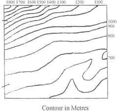
The above contours of an area indicate several, relief features. Which one among the following relief features is not depicted here?
A)
Steep slope done
clear
B)
River valley done
clear
C)
Conical hill done
clear
D)
Gentle slope done
clear
View Solution play_arrow
-
question_answer66)
Which of the following statements concerning Mediterranean climatic region are correct? [NDA/NA 2016-II]
| 1. It is found in the latitude range 30° to 45° northern and southern hemisphere |
| 2. Mediterranean climate experiences extreme temperature conditions. |
| 3. In Mediterranean climate, rainfall occurs mainly during summer season |
| 4. Mediterranean climate, rainfall is mainly due to westerlies. |
Select the correct answer using the code given below:
A)
1, 2 and 4 done
clear
B)
1 and 4 only done
clear
C)
1, 2 and 3 done
clear
D)
3 and 4 done
clear
View Solution play_arrow
-
question_answer67)
Which one of the following is the correct descending order of countries in terms of per capita availability of arable land? [NDA/NA2016-II]
A)
India- China - Brazil done
clear
B)
China - Brazil - India done
clear
C)
Brazil - China - India done
clear
D)
Brazil - India - China done
clear
View Solution play_arrow
-
question_answer68)
Which of the following statement(s) concerning natural regions of the world is/are correct?
| 1. Equatorial climate regions have less urbanization |
| 2. Mediterranean climatic region have high level of urbanization |
| 3. Equatorial climatic regions have high concentration of human population |
| 4. Mediterranean climate regions practice plantation fanning |
Select the correct answer using the code given below:
A)
1 and 2 only done
clear
B)
1, 2 and 3 done
clear
C)
2 and 4 done
clear
D)
1 only done
clear
View Solution play_arrow
-
question_answer69)
Match List I with List II and select the correct answer using the code given below the Lists: [NDA/NA 2015-II]
| List-I (Low-Latitude Climate) | List-II (Characteristic) |
| A. | A. Wet Equatorial | 1. | 1.Uniform temperatures, mean near \[{{27}^{o}}C\] |
| B. | B. Monsoon and trade wind coastal | 2. | 2.Marked temperature cycle with very high temperature before the rainy season |
| C. | C. Wet-dry tropical | 3. | 3. Temperatures show an annual cycle with high temperature in the high Sun season |
| D. | D. Dry tropical | 4. | 4. Strong temperature cycle, with intense temperature during high-Sun season |
A)
A-2 B-3 C-4 D-1 done
clear
B)
A-1 B-2 C-3 D-4 done
clear
C)
A-2 B-4 C-3 D-1 done
clear
D)
A-1 B-3 C-2 D-4 done
clear
View Solution play_arrow
-
question_answer70)
DIRECTIONS: The following six (6) items consist of have statements, Statement I and Statement II. You are to examine these two statements carefully and select the answers to these items using the code given below: [NDA/NA 2014-I]
| Statement I: Chemical weathering processes are found more active in hot and humid environment. |
| Statement II: High temperature and rainfall help in the process of decomposition of rocks. |
A)
Both the statements are individually true and Statement II is the correct explanation of Statement I done
clear
B)
Both the statements are individually true but Statement II is not the correct explanation of Statement I done
clear
C)
Statement I is true but Statement II is false done
clear
D)
Statement I is false but Statement II is true done
clear
View Solution play_arrow
-
question_answer71)
The Faroe is a group of islands lying in the Atlantic Ocean between Scotland and Iceland. This island group is also known as [NDA/NA 2014-I]
A)
Island of Sheep done
clear
B)
Island of Goats done
clear
C)
Island of Cows done
clear
D)
Island of Buffaloes done
clear
View Solution play_arrow
-
question_answer72)
The rigid lithospheric slabs are known as 'Pates'. What would be the result, if the oceanic plate collides with the continental plate? [NDA/NA2013-II]
| 1. Oceanic plate is forced below the continental plate. |
| 2. Continental plate is forced below the oceanic plate. |
| 3. Continental and oceanic plates never collide. |
Select the correct answer using the code given below:
A)
1 only done
clear
B)
2 only done
clear
C)
1 and 2 only done
clear
D)
1, 2 and 3 done
clear
View Solution play_arrow
-
question_answer73)
The 'Ring of Fire' is associated with [UP-PCS 2008]
| 1. Earthquake |
| 2. Volcanoes |
| 3. Pacific Ocean |
| 4. Forestres |
Choose your answer with the help of codes given below Code:
A)
1, 2 and 3 done
clear
B)
2 and 3 done
clear
C)
2 and 4 done
clear
D)
1, 2, 3 and 4 done
clear
View Solution play_arrow
-
question_answer74)
Which of the following are cold ocean currents? [UP-PCS 2009]
| 1. Humboldt current |
| 2. Brazil current |
| 3. Oyashio |
| 4. Canary current |
Select the correct answer from the codes given below:
A)
1 and 2 done
clear
B)
2 and 3 done
clear
C)
1, 3 and 4 done
clear
D)
2, 3 and 4 done
clear
View Solution play_arrow
-
question_answer75)
Which one of the following is a warm ocean current? [UP-PCS 2009]
A)
East Australian current done
clear
B)
West Australian current done
clear
C)
Benguela current done
clear
D)
Peru current done
clear
View Solution play_arrow
-
question_answer76)
Which of the following seas has the highest salinity? [UP-PCS 2012]
A)
Caspian sea done
clear
B)
Mediterranean sea done
clear
C)
Red sea done
clear
D)
Dead Sea done
clear
View Solution play_arrow
-
question_answer77)
Match List -I with List - II and select the correct answer from the codes given below the lists: [UP-PCS 2013]
| List-I (River) | List-II (Dam) |
| A. Colorado | 1. Aswan |
| B. Damodar | 2. Kariba |
| C. Nile | 3. Panchet |
| D. Zambezi | 4. Hoover |
A)
A-1 B-2 C-3 D-4 done
clear
B)
A-1 B-3 C-4 D-2 done
clear
C)
A-3 B-4 C-1 D-2 done
clear
D)
A-4 B-3 C-1 D-2 done
clear
View Solution play_arrow
-
question_answer78)
Match List -I with List - II and select the correct answer using the codes given below: [UP-PCS 2014]
| List-I | List-II |
| A. Bushfires | 1. U.S.A. |
| B. Hurricanes | 2. Australia |
| C. Typhoons | 3. Philippines |
| D. Baguio | 4. China |
A)
A-1 B-2 C-3 D-4 done
clear
B)
A-2 B-1 C-4 D-3 done
clear
C)
A-1 B-2 C-4 D-3 done
clear
D)
A-2 B-1 C-3 D-4 done
clear
View Solution play_arrow
-
question_answer79)
Which of the following temperate grasslands are found in Eurasia? [UP-PCS 2014]
A)
Downs done
clear
B)
Velds done
clear
C)
Steppes done
clear
D)
Praires done
clear
View Solution play_arrow
-
question_answer80)
Which one of the following is the highest volcanic mountain of the world [UP-PCS 2015]
A)
Mount Pinatubo done
clear
B)
Mount Kilimanjaro done
clear
C)
Mount Taal done
clear
D)
Mount Cotopaxi done
clear
View Solution play_arrow
-
question_answer81)
Which pair amongst the following is not correctly matched? [UP-PCS 2015]
A)
The queen of Adriatic sea - Rome done
clear
B)
Lorraine coal fields - France done
clear
C)
West Midlands - Birmingham done
clear
D)
Tula - Russia done
clear
View Solution play_arrow
-
question_answer82)
Match List - I with List -II and select the correct answer from the codes given below the lists: [UP-PCS 2015]
| List -1 (Volcano) | List - II (Country) |
| A. Sabancaya | 1. Italy |
| B. Mount Etna | 2. Peru |
| C. Colima | 3. Indonesia |
| D. Merapi | 4. Mexico |
A)
A-3 B-1 C-4 D-2 done
clear
B)
A-3 B-2 C-1 D-4 done
clear
C)
A-2 B-1 C-4 D-3 done
clear
D)
A-4 B-3 C-2 D-1 done
clear
View Solution play_arrow
-
question_answer83)
Which one of the following countries has the longest coastal line? [UP-PCS 2015]
A)
Mia done
clear
B)
Canada done
clear
C)
Australia done
clear
D)
Brazil done
clear
View Solution play_arrow
-
question_answer84)
Which one of the following pairs is not correctly matched? [UP-PCS 2015]
A)
Boiling lake - Dominica done
clear
B)
Five Flower lake - Mangolia done
clear
C)
Red Lagoon - Bolivia done
clear
D)
Great Slave Lake - Canada done
clear
View Solution play_arrow
-
question_answer85)
The largest river of Asia is- [UP PCS (M) 2016]
A)
Indus done
clear
B)
Brahmputra done
clear
C)
Yangtze done
clear
D)
Hwang Ho done
clear
View Solution play_arrow
-
question_answer86)
Which one of the following continents was not a part of Gondwana Land? [UP PCS (M) 2016]
A)
North America done
clear
B)
South America done
clear
C)
Africa done
clear
D)
Australia done
clear
View Solution play_arrow
-
question_answer87)
Which of the following is not correctly matched? [UP PCS (M) 2016]
A)
B)
C)
D)
View Solution play_arrow
-
question_answer88)
Which one of the following continents has all types of climatic zones? [UP PCS (M) 2016]
A)
South America done
clear
B)
North America done
clear
C)
Australia done
clear
D)
Asia done
clear
View Solution play_arrow
-
question_answer89)
What does 'ITCZ' mean? [Bihar J. Service 2016]
A)
Inter-Temperate Convergence Zone done
clear
B)
Inter-Topical Convergence Zone done
clear
C)
India-Thailand Convergence Zone done
clear
D)
Inter-Tropical Convergence Zone done
clear
View Solution play_arrow
-
question_answer90)
Match the List-I and List-II and choose the correct code given below:
| List-I (Plateau) | List-II (Country) |
| A. Pamir | 1. Australia |
| B. Kimberley | 2. Spain |
| C. Meseta | 3. Tajikistan |
| D. Yukon | 4. Canada |
A)
A-1 B-2 C-3 D-4 done
clear
B)
A-4 B-3 C-2 D-1 done
clear
C)
A-3 B-1 C-2 D-4 done
clear
D)
A-3 B-2 C-1 D-4 done
clear
View Solution play_arrow
-
question_answer91)
Which is the largest riverine Islands of the World'?
A)
Majuli Island in Brahmaputra River in Assam done
clear
B)
Marajo Island in Amazon River in Brazil done
clear
C)
Tupinambarana Island in Amazon River in Brazil done
clear
D)
Boven Digul Island in Digul River in Indonesia done
clear
View Solution play_arrow
-
question_answer92)
The Tatagonian Desert' is situated in- [BOM-PO 2016]
A)
Central Africa done
clear
B)
Eastern Europe done
clear
C)
Central Asia done
clear
D)
South America done
clear
View Solution play_arrow
-
question_answer93)
At what altitude are Alpine forests found'? [UK-PSC(F)2015]
A)
1800 - 2000 m done
clear
B)
900 - 1800 m done
clear
C)
2000 - 2500 m done
clear
D)
2900 - 3500 m done
clear
View Solution play_arrow
-
question_answer94)
Which of the following is not a major plate of the world'?
A)
American plate done
clear
B)
Caribbean plate done
clear
C)
Australian plate done
clear
D)
Pacific plate done
clear
View Solution play_arrow
-
question_answer95)
Given below are two statements, one labelled as Assertion and other labelled as Reason (R). Select your answer from the codes given below: [LGC (Geog) 2016]
| Assertion [A]: Land surface is heated more quickly and to a greater extent than the water surface when subjected to equal amount of insolation. |
| Reason [R]: The land is opaque while water is transparent to solar radiation. |
A)
Both A and R are true, and R is correct explanation of A. done
clear
B)
Both A and R are true, but R is not correct explanation of A. done
clear
C)
A is true, but R is false. done
clear
D)
A is false, but R is true. done
clear
View Solution play_arrow
-
question_answer96)
Stromboli is a/an- [M P - PSC 2017]
A)
dormant volcano done
clear
B)
active volcano done
clear
C)
extinct volcano done
clear
D)
None of the above done
clear
View Solution play_arrow
-
question_answer97)
Huangpu River flows through which one of the following cities?
A)
Beijing done
clear
B)
Ho Chi Minch City done
clear
C)
Shanghai done
clear
D)
Manila done
clear
View Solution play_arrow
-
question_answer98)
'Palk Strait' is a narrow channel of sea between-
A)
India and Sri Lanka done
clear
B)
Bangladesh and Myanmar done
clear
C)
Egypt and Iraq done
clear
D)
France and England done
clear
View Solution play_arrow
-
question_answer99)
Severe tropical typhoon 'Nida' in (August 2016) hit the city of Shenzhen- [RBI 2016]
A)
China done
clear
B)
Thailand done
clear
C)
Japan done
clear
D)
Indonesia done
clear
View Solution play_arrow
-
question_answer100)
Which one of the following processes is responsible for the weathering of rocks in a Karst region? [UGC-II (Geog) 2016]
A)
Hydrolysis done
clear
B)
Carbonation done
clear
C)
Oxidation done
clear
D)
Scree formation done
clear
View Solution play_arrow
-
question_answer101)
The term pan plane refers to- [UGC-II (Geog) 2016]
A)
A level surface formed by wind erosion done
clear
B)
A plane formed by joining of flood-plains done
clear
C)
A level surface formed by the fluvial cycle at the old age done
clear
D)
A level plain formed by human intervention done
clear
View Solution play_arrow
-
question_answer102)
Which one of the following deserts is famous for the deposits of Nitrates? [UGC-II (Geog) 2016]
A)
Sahara done
clear
B)
Gobi done
clear
C)
Kalahari done
clear
D)
Atacama done
clear
View Solution play_arrow
-
question_answer103)
Maximum Coastal erosion is caused by- [UK-PSC 2016]
A)
Waves done
clear
B)
Tides done
clear
C)
Currents done
clear
D)
Tsunami waves done
clear
View Solution play_arrow
-
question_answer104)
Which of the following statements is correct about cryosphere?
A)
These are such parts of earth's system where temperature goes down below \[{{0}^{o}}C\] at least one year done
clear
B)
The largest component of Cryosphere is the belt of Greenland and Antarctica. done
clear
C)
Marine snow, ice shelf, frozen land and ice caps the components of Cryosphere done
clear
D)
All the above done
clear
View Solution play_arrow
-
question_answer105)
Which of the following is not correctly matched?
A)
Mt. Rainier-USA done
clear
B)
Mt. Etna - Italy done
clear
C)
Paricutin - Mexico done
clear
D)
Taal-Argentina done
clear
View Solution play_arrow
-
question_answer106)
Summer rains in Australia broadly decreases from- [SSC 2016]
A)
east to west done
clear
B)
west to east done
clear
C)
north to south done
clear
D)
south to north done
clear
View Solution play_arrow


