| Study the map given below carefully and answer the questions that follow: |
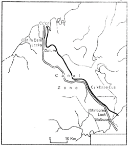 |
| 1. Identify and name the canal shown in the map. |
| 2. State any four features of this canal. |
| Study the given diagram carefully and answer the questions that follow: |
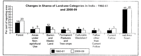 |
| (1) Which land use category has shown the highest increasing trend? What percentage in reporting area has increased in that category, during the given period? |
| (2) Explain any two reasong responsible for the increasing trend in that category. |
| Identify the five Geographical features shown on the political outline map of the World as A, B, C, D and E and write their correct names on the lines marked near them with the help of following information: |
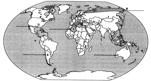 |
| (A) A large country of Europe in area. |
| (B) An area of subsistence gathering. |
| (C) The terminal station of a 'trans-continental railway'. |
| (D) A major sea-port. |
| (E) An international airport. |
| Locate the label the following features with approximate symbols on the given political outline map of India. |
| (i) The most urbanized state (2011) |
| (ii) The leading cotton producing state. |
| (iii) The Software Technology Park located in Punjab. |
| (iv) The major coal field located in Chhattisgarh. |
| (v) The international airport located in Karnataka. |


You need to login to perform this action.
You will be redirected in
3 sec

