HYDROSPHERE
Category : UPSC
HYDROSPHERE
INTRODUCTION
Hydrosphere refers to the total amount of water present on or under the surface of a planet. About three-Perth of the globe is covered by hydrosphere. Out of the total surface area of the globe (509, 950, 000\[k{{m}^{2}}\]) hydrosphere and Lithosphere cover 361,060,000\[k{{m}^{2}}\] (about 71 percent) and 148,890,000 \[k{{m}^{2}}\](about 29 percent) respectively. Hydrosphere plays significant role in the biosphere as:
HYDROLOGICAL CYCLE
Commonly known as the water cycle. It is the circular flow
of water within earth's atmosphere, involving all the three
forms of matter such as solid, liquid and gaseous forms. It also refers to the continuous exchange of water from the one form to another with the application of external energy. Through various process of physical action such as evaporation, condensation, precipitation, interception, infiltration, runoff, surface flow.
Evaporation is the process of transformation of water from the water bodies to water vapour in the atmosphere.
Condensation is the process of changing the state from water vapour to water in the upper air. It generally takes the form of cloud.
Precipitation is the downpour of condensed cloud mostly in the form of rainfall, and sometimes as snow, hails, fog, drop, etc.
Infiltration is the process of penetration of water into
underground strata of earth's crust.
Interception is the precipitation trapped by vegetation instead of falling on ground.
Run off is the movement of water on the earth, surface through different channels such as river, streams, etc.
Subsurface Flow is the movement of w''ater within the earth's crust after infiltration which eventually either come up through artesian well or seep to the ocean. Fishes are the important members of there community. They are further categorised into
Pelagic fish - who leaves neither too close to share nor to the bottom.
Demersal fish - On the contrary these fishes occupy the bottom area of the sea. Other than fishes this community is also famous for marine mammals which are again divided into two categories The mammals who can stay both in water and land for example seal
The second category of mammals spend their entire life in side the sea.
COMPONENTS OF HYDROSPHERE
There are four major components of Hydrosphere.
Oceans
Fresh water
Glacial water
Atmospheric water vapour
(a) Surface water
(b) Ground water
(a) Surface water: Oceans, seas, lakes, ponds, rivers and
streams are main examples of surface water.
(b) Ground water: Ground water is found in soil pores,
rocks, aquifers and springs. The water percolates through
pores in rock and soil filling all the available spaces.
|
Distribution of water through different Sources (in %) |
|
|
Oceans |
97.3 Saline Water |
|
Ice-cap and glaciers |
2.05 |
|
Ground water |
0.68 |
|
Fresh water lakeO.009 |
Fresh Water |
|
Inland sea and salt lakes |
0.009 |
|
Atmosphere |
0.0019 |
|
Rivers |
0.0001 |
Oceans
As major portion of Earth's Hydrosphere is covered by ocean we are now going to discuss. Ocean and its various features. An ocean (from Ancient Greek Okeanos,) is a body of saline water that composes much of a planet's hydrosphere. One Earth, an ocean is one of the major conventional divisions of the world Ocean, which covers almost 71% of its surface. These are, in descending order by area, the pacific, Atlantic, Indian, Southern and Arctic Oceans. The word sea is often used interchangeably with "ocean" in American English but, strictly speaking, a sea is a body of saline water (generally a division of the world ocean) partly or fully enclosed by land.
Ocean Structure
(i) the ocean
(ii) the sea.
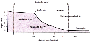
Ocean Relief
Ocean floor is characterized by four relief zone which are as follows:
(1) Continental Shelf
(2) Continental Slope
(3) Deep Sea Plain / Abyssal Plain
(4) Ocean Deep
Hypsometric/Hypsographic curve
Hypsometric/Hypsographic curve
The continental shelf is margin of continent are submerged under ocean water upto 100 fathoms (600 feet).
Origin
Origin
Continental slope is formed due to erosion, tectonic and aggradations (increase in land elevation).
(i) Deep - It has great depth and is less extensive
depression.
(ii) Trenches - It is a long and narrow linear depression.
Submarine Canyon
It is long, narrow and very deep valley or trenches. It is located on the continent shelf and slope with vertical walls. It is at maximum 16 km long. Morphogenetic classification:
(i) Glacially eroded and
(ii) Non-glacial eroded
|
Continental Rise It is a depositional feature made up of thick sequences of continental material that accumulate between the continental slope and the abyssal plain. |
|
Sea Mount Mountain within ocean does not reaches the water surface is called sea mount. When the top of this mount is eroded by currents making its top flat, it is known as guyot. |
Ocean Ridge
It is a continuous submarine mountain chain extending to thousands of kilometers. The ridges rise from depths near 5 km (3 miles) to an essentially uniform depth of about 2.6 km (1.6 miles) and are roughly symmetrical in cross section. It is formed across transform faults within fracture zones. World
Major Trenches and Ridges in World
The cavity located near the Mariana Islands, where the Pacific Plate and the Philippine Plate converge; it is the world's deepest trench (about 36,000 feet).
It is located off the coast of Puerto Rico, on the boundary between the South American and Caribbean plates; it features the deepest point in the Atlantic Ocean (27,493 feet).
The trench (26,460 feet) borders South America and it is the world's longest trench (3,700 mi), located on the boundary between the Nazca Plate and the South American Plate.
Mountain range separating the Pacific and Antarctic plates; it joins the eastern Pacific Ridge off the coast of South America.
Ridge that marks the boundary between the Pacific and Cocos Islands plates to the north, and the Pacific and Nazca plates to the south.
Trench (25,600 feet) extending from Alaska to the
Kamchatka Peninsula; it results from the Pacific Plate sliding beneath the North American Plate.
Its area (9.3 million sq. mi) represents about 16% of the world's land; the Central American isthmus is an extension of North America.
Mountain range in the middle of the Indian Ocean that separates the African and Australian-Indian plates.
Ridge separating the African and Antarctic plates; it joins the Mid-Indian and Southeast Indian ridges off the coast of Madagascar.
Represents about 12% of the world's land and is linked to North America by Central! America; its features include the Andes in the west and plains and plateaus in east and central regions,
Ridge about 7,000 miles long, located in the middle of the Atlantic Ocean; some of its mountains reach the surface, forming islands such as Iceland.
Trench (24,629 feet) located near the Ryukyu Islands; it marks the boundary between the Philippine Plate and the Eurasian Plate.
Trench (27,929 feet) located east of Japan, on the boundary between the Pacific Plate and the Eurasian Plate; this zone is marked by intense seismic activity.
Trench (34,587 feet) located northeast of Japan; it results from the Pacific Plate sliding beneath the Eurasian Plate.
Trench bordering the eastern Philippines, reaching depths of 34,578 feet; it results from the Philippine Plate sinking beneath the Eurasian Plate.
Cavity located north of New Zealand, where the Pacific Plate meets the Australian-Indian Plate; it reaches depths of 35,702 feet.
Ridge separating the Antarctic Plate from the Australian- Indian Plate; its topography is more regular than the topography of the Southwest Indian and Mid-Indian ridges.
Trench located south of Indonesia, between the Australian- Indian and the Eurasian Plates; it is the deepest point inthe Indian Ocean (24,440 ft).
Temperature of Ocean
(i) Epilimnion Layer is the first layer which is upto 500 m from top having temperature of \[20{}^\circ \] - \[25{}^\circ \]C.
(ii) Thermocline Layer is below 500 m to 1000 in where temperature decreases at a rapid rate with the increase in depth,
(iii) Hypolimnion Layer is the third layer, very cold in nature and extend upto deep ocean floor from 1000 m. Only Polar region has this layer starting from surface to deep ocean form.
Daily Range of temperature is the difference of maximum and minimum temperature of a day
Annual Range of Temperature
|
Mean Annual Temperature of Water |
|
|
Ocean |
Mean Temperature (in \[{}^\circ C\]) |
|
Pacific |
19.1 |
|
Atlantic |
16.9 |
|
Indian |
17.0 |
|
Average |
17.4 |
Factors affecting Distribution of Temperature
Other factors: Submarine ridges, shape of sea, local weather conditions.
Horizontal distribution
Vertical Distribution
(i) Photic/ Euphotic zone is the upper surface upto the depth of 200 m and receives solar radiation.
(ii) Alphatic zone goes beyond 200 m depth to the bottom and receives no solar ray.
Density of Ocean
Factors controlling density
Temperature is inversely proportional to density, whereas pressure and salinity are directly related to it.
Density stratification of Ocean
(i) Surface layer
It has lowest density, having thickness of 100 to 200 m and is called as photic zone. Only 2% of seawater is found there. The zone is important for the growth of phytoplankton through the process of photosynthesis. Phytoplankton is eaten by zooplankton, it initiates food chain process.
(ii) Pycocline layer
It is a transition zone characterized by rapid change of density. It is found between 300 m - 1000 m depth of ocean water. 18% of the total volume of the ocean water lies in this zone.
(iii) Deep layer
It has high density. Water mass beyond 1000 m depth to the ocean floor contain 80% of the total volume of ocean water. It denotes high density and low temperature.
Salinity of the Ocean
|
(Salts in Ocean Water) |
|
|
Name of Salts |
In% |
|
Sodium Chloride \[(NaCL)\] |
77.8 |
|
Magnesium Chloride \[(MgC{{L}_{2}})\] |
10.9 |
|
Magnesium Sulphate \[(MgS{{O}_{4}})\] |
04.7 |
|
Calcium Sulphate \[(CaS{{O}_{4}})\] |
03.6 |
|
Potassium Sulphate \[({{K}_{2}}S{{O}_{4}})\] |
02.5 |
|
Calcium Carbonate \[(CaC{{O}_{3}})\] |
00.3 |
|
Magnesium Bromide \[(MgB{{r}_{2}})\] |
00.2 |
Factors controlling salinity
Distribution
Ocean Deposits
Sources and Types of Marine Deposits
On the basis of origin Marine deposits can be classified into the following groups:
(1) Terrigenous deposits
(2) Volcanic deposits
(3) Biotic matter/ Organic deposits
(4) Abiotic matter/ Inorganic deposits
(1) Terrigenous deposits
(2) Volcanic deposits
Derived from two sources:
(i) Volcanic eruption on level (land) and
(ii) Volcanic eruption in the ocean.
(3) Organic deposits
Skeleton of marine organism divided into two:
(i) Neretic matter: Skeletons of organism.
(ii) Pelagic matter: Remains of algae found in liquid mud, generally called as ooze.
Oozes are divided into two
(a) Calcareous oozes contain lime and are of two types:
(i) Pteropod oozes are formed of floating shells of pteropod molluscs. These shells are conical in shape and 'A inches in diameter. Contain 80% of calcium and found in tropics at depth of 300-1000 fathoms of water and disappears at 2000 fathoms.
(ii) Globigerina oozes are formed from the shells of foraminifera. They contain 64% of calcium, 1.64% of silica and 3.3% of mineral. Usually found in topics and temperate zone of Atlantic Ocean, west coast of Indian Ocean and in eastern Pacific oceans continental shelves.
(b) Siliceous oozes: Derive from a group of protozoa or radiolarian and benthic animals (sponges). These oozes do not dissolve unlike calcareous oozes. They are found in both warm and cold water at great depth and are of two types such as:
(i) Radiolarian oozes are fanned by shells of radiolarian and foraminifera. Silica dominates and lime content increases with increasing depth. 2000 to 5000 fathoms is the depth between which they are found.
(ii) Diatom oozes are formed of shells of very microscopic plants rich in silica. They are blue near land and yellow or cream away from land.
(4) Inorganic deposits
Red Clay
Previously considered to be of organic origin, is the most significant inorganic matter and very important member of pelagic deposits.
Coral Reefs and Atoll
Condition for Growth
Mainly Found in Tropical Oceans and seas.
Types of Coral Reef
The submarine reefs are classified on the basis of nature, shape and mode of occurrence: (i) fringing reef, (ii) barrier reef, and atoll.
(i) Fringing Reef
Fringing Reefs are found in Sakau island southern florida, mehetia island, etc.
(ii) Barrier Reef
Great Barrier rief located parallel to the east coast of Australia is the largest barrier reef.
(iii) Atoll
(i) True atoll: Characterized by circular reef enclosing a shallow lagoon but without Island.
(ii) Island atoll: having on Island in the central part of the lagoon enclosed by circular reef, and
(iii) Coral Island or atoll Island does not have island in the beginning but later on Island is formed due to erosion and deposition by marine waves.
Some Famous Coral Reefs in the World
The Great Barrier Reef
It is the large coral reef in the world. It is located in eastern coast of Queensland in Australia. It has 2,900 individual reefs, and 900 islands stretching for over 2,300 kilometers within an area of approximately 344,400 square kilometers.
The Belize Barrier Reef
The coastal area of Belize consists of the largest barrier reef in the northern hemisphere, offshore atolls, several hundredsand cays, mangrove forests, coastal lagoons and estuaries. It is habitat for threatened species, including marine turtles, manatees and the American marine crocodile.
The Red Sea Reef
It is found on the coast of Red sea and is the northern most reef found in Indian ocean, extending 2,000 km. Fringing reef systems is developed enormously over here.
The Pulley Reef
It is located on the coast of Florida, USA. The corals Agaricia sp. is found here in tan-brown shade largely.
Coral Bleaching
Coral bleaching refers to loss of algae from the corals resulting into the white colour which is indicative of death of corals. Scientifically it is the process of loss of intracellular endosymbionts or zoonanthellae either through expulsion or lost of algae pigmentation. In general it can be viewed as the indicative death of corals with the increase in ocean temperature the coral starts expelling the algae living in their tissue and as a result the corals get completely white.
Causes
Global warming which leads to increase in the temperature of ocean water. Near share corals bleach due to storm generated precipitation which cany pollutants and contaminate ocean water. Over exposure to sunlight leads to the increase in temperature of ocean water and hence result into coral bleaching. Expocure to air due to extreame lowtides.
Ocean Tide
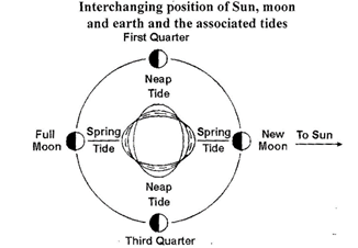
Origin
The tidal force of moon is maximum during perigee as the distance is less. The resultant tide is known as perigean tide which is 15-20%. Higher than normal tides.
On the contrary during Apoge, due to maximum distance of moon from earth the tidal force is less hence resulting into
Apogean tides 20% lesser than normal tides.
Types of Tide
(i) Spring Tide
(ii) Neap tide
(iii) Apogean and Pengean tide
(iv) Tropical and Equatorial tide
(v) Daily and semi durinal tide
(vi) Equenoctical tide
Apogean & Perigean Tides
(i) Spring tide
When the sun, the moon and the earth are in the same line, there is formation of spring tide.
Types of Tide
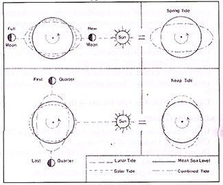
(ii) Neap tide
It is a quadrature position between the earth, the sun and the moon on seventh or eighth day of the fort night. During this time the forces of the sun and the moon acts in opposite direction. It is 20% lower than normal tide. Tides clear the sediments brought by rivers, retarding the development of delta and clean the coast.
(iii) Perigean and Apogean Tides
When the moon is nearest to the earth in its orbit (at perigee), its tide-producing power is greater than average, resulting in perigean tides. These are 15-20% greater than average. When the moon is farthest from the earth (apogee), the tides are called apogean tide, which are about 15-20% less than average. Coincidence of spring and perigean tides results in an abnormally great tidal range, while when neap and apogean tides coincide the range is abnormally small.
(iv) Tropical and Equatorial Tides
Like the sun moon also undergoes the process of north and southward declination and to complete it. Moon requires 27.5 days of time, which is known as synodic month. During mainmum declination the moon rays are vertical on the tide centre and results into formation of spring tides near Tropic of cancer in northward position and tropic of Capricorn in southward position.
When the moon is vertical on the equator there is no such diurnal change between the neap and spring tides in terms of their height. These types of tides are called as Equatorial tides.
(v) Daily & Semi-diurnal Tides
The tides only verity in terms of time duration daily tides occure in an interval of 24 hrs. and 52 min where on semi- diurnal tides occur in 12 hours and 26 min.
(vi) Equinoctical Spring tides
These are forms of spring tides which occurs in a time interval of 6 months.
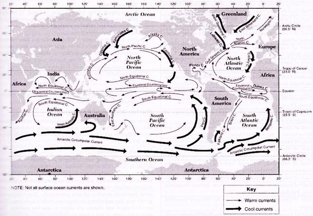
Ocean Currents
The movement of a mass of oceanic water parallel to the coast is called as ocean current.
Currents are of two types on the basis of temperature.
(i) Warm current
(ii) Cold current
On the bases of velocity, dimension and direction.
Drift: It is slow movement of the ocean current under the influence of prevailing wind.
Current: Movement or circulation of ocean water in a definite path having great velocity.
Stream: Movement of ocean water involving large volume in a definite direction with velocity. It is a continuous flow.
Origin
Origin of ocean current occurs due to following factors:
(i) Rotation of earth
(ii) Temperature difference in ocean
(iii) Salinity difference in ocean
(iv) Density Difference
(v) Air pressure and wind
(vi) Rainfall and Evaporation
(vii) Direction, shape and configuration of coast
(viii) Bottom relief
(ix) Seasonal variation
Distribution of Currents
Atlantic Ocean
North Equatorial Current (warm)
South Equatorial Current (warm)
Counter Equatorial Current (warm)
Gulf Stream (warm)
Canary Current (Cold)
Labrador Current (Cold)
Brazil Current (warm)
Falkland Current (Cold)
South Atlantic Drift (Cold)
Benguela Current (Cold)
Pacific Ocean
(i) Kuroshio Current
(ii) Kuroshio extension
(iii) North Pacific Drift
(iv) Tsushima Current
(v) Counter Kuroshio Current
Indian Ocean
SEAS OF OCEAN
Pacific Ocean
Arafura sea, Bering sea, Celebes sea, Coral sea, Java sea, Gulf of Carpentria, Yellow sea, Japan sea, Bohol sea. Gulf of Alaska, Molucca Sea and South China Sea.
Indian Ocean
Arabian sea, Andaman Sea, Bay of Bengal, Timor sea, Red sea, Laccadive sea, Gulf of Oman, Gulf of Aden, Mozambique Channel.
Atlantic Ocean
Caribbean sea, Celtic sea, Labrador sea, Marmara sea, Norwegian sea, Bothnia sea, Gulf of Finlang, Bay of Fundy, Barents sea, Beaufort sea, Amunden sea, Baffin Bay, Laptev sea, White sea, Pechora sea, Kara sea, East Siberian sea, Greenland sea, Prince Gustav Adolf sea.
Inland Seas
Caspian Sea, Aral Sea, SaIton Sea. Dead Sea and Black sea.
Strait is a narrow passage of water connecting two seas or two other large areas of water.
Strait of Malacca is a funnel-shaped narrow waterway of 800 km long that connects the South China & Andaman Sea.
Bass Strait is the widest (240 km). The narrowest strait in world used for international navigation, the Bosporus connects the Black Sea with the Sea of Marmara.
|
Major Strait of the World |
||
|
Name |
Joins |
Location |
|
Malacca Strait |
Andaman Sea & South China Sea |
Indonesia - Malaysia |
|
Palk Strait |
Palk Bay & Bay of Bengal |
India-Sri Lanka |
|
Sunda Strait |
Java Sea & Indian Ocean |
Indonesia |
|
Yucatan Strait |
Gulf of Mexico and Caribbean Sea |
Mexico-Cuba |
|
Messina Strait |
Mediterranean Sea |
Italy-Sicily |
|
Otranto Strait |
Adriatic Sea & Ionian Sea |
Italy-Albania |
|
Bab-el-Mandeb Strait |
Red Sea & Gulf of Aden |
Yemen-Djibouti |
|
Cook Strait |
South Pacific Ocean |
New Zealand (N & S islands) |
|
Mozambique Strait |
Indian Ocean |
Mozambique - Malagasy |
|
North Channel |
Irish Sea & Atlantic Ocean |
Ireland-England |
|
Taurus Strait |
Arafura Sea & Gulf of Papua |
Papua New Guinea - Australia |
|
Bass strait |
Tasman Sea & South Sea |
Australia |
|
Bering Strait |
Bering Sea & Chukchi Sea |
Alaska-Russia |
|
Bonne-Fasio Strait |
Mediterranean Sea |
Corsika-Sardinia |
|
Bosphorus Strait |
Black Sea and Marmara Sea |
Turkey |
|
Dardanelle Strait |
Marmara Sea and Aegean Sea |
Turkey |
|
Davis strait |
Baffin Bay & Atlantic Ocean |
Greenland-Canada |
|
Denmark strait |
North Atlantic and Arctic Ocean |
Greenland-Iceland |
|
Dover strait |
English Channel & North Sea |
England-France |
|
Florida Strait |
Gulf of Mexico and Atlantic Ocean |
USA-Cuba |
|
Honnuz strait |
Gulf of Persia & Gulf of Oman |
Oman-Iran |
|
Hudson strait |
Gulf of Hudson & Atlantic Ocean |
Canada |
|
Gibraltar Strait |
Mediterranean Sea & Atlantic Ocean |
Spain-Morocco |
|
Magellan strait |
Pacific and South Atlantic Ocean |
Chile |
|
Makassar Strait |
Java Sea & Celebeze Sea |
Indonesia |
|
Tsugaru Strait |
Japan Sea and Pacific Ocean |
Japan (Hokkaido-Honshu island) |
|
Tatar Strait |
Japan Sea & Okhotsk Sea |
Russia (E Russia-Sakhalin Island) |
Gulf
A large area of a sea or ocean partially enclosed by land, especially a long landlocked portion of sea opening through a strait. Gulf and Bay are of economic importance as they serve as excellent harbor in most of the cases. Many important trading centers are located on gulfs. It forms a good fishing ground and oil deposits.
Bay
A bay is a small body of water or a broad inlet that is set of from a larger body of water generally where the land curves inward Examples of bays include the Bay of Pigs (Cuba), Hudson Bay (Canada), Chesapeake Bay (Maryland and Virginia), and Bay of Bengal (near India).
When a body of water such as a strait is capable of being blocked or even closed in order to control transportation routes, the body is called a “choke point”
Estuaries
Estuaries are bodies of water and their surrounding coastal habitats typically found where rivers meet the sea. It becomes the home of numerous unique plant and animal communities because their waters are brackish. Brackish is a mixture of fresh water draining from the land and salty seawater.
Coastal Plain
Melting of snow in past rose the sea level as the stream and rivers got flooded with water. The Chesapeake Bay in Maryland and Narragansett Bay in Rhode Island are examples of such estuaries that were once river valleys.
Bar-built
Sandbars or barrier islands built up by ocean currents and waves in coastal areas created a protected area fed by small streams or rivers. The barrier islands off the Atlantic coastline of North
Carolina and Massachusetts enclose bar-built estuaries.
Delta system
Deltas are formed at the mouths of large rivers from sediment and silt depositing. When the river flow is restricted by the delta, an estuary may form. The Nile River in Egypt and the Mississippi River in Louisiana forms delta systems estuaries.
Tectonic
It is created when a major crack or a large landmass sink, often caused by earthquakes, produced a basin below sea level that fills with water. This type of estuaries usually occurs along fault lines. San Francisco Bay in California is an example of an estuary created by tectonics.
Fjords
Advancing glaciers ground out long, narrow valleys with steep sides. Then when glaciers melted, seawater flooded in. Glacier Bay in Alaska is an example of a fjord.
Surface Ocean Currents
|
Major Gulfs and their Location |
|
Gulf of Aden of the southwestern comer of the Arabian Peninsula |
|
Gulf of Alaska in the Pacific Ocean south of the state of Alaska |
|
Amundsen Gulf in the Arctic Ocean northwest of Canada |
|
Gulf of Aqaba in the northern end of the Red Sea, leading to Israel and Jordan |
|
Gulf of Bahrain, part of the Persian Gulf |
|
Gulf of Bothnia, part of the Baltic Sea between Sweden and Finland |
|
Gulf of Cadiz, part of the Atlantic Ocean off the southern border of Spam and Portugal |
|
Gulf of California in the Pacific Ocean in northwestern Mexico |
|
Gulf of Carpentaria a large bay off northern Australia |
|
Gulf of Cazones a large gulf in southern Cuba |
|
Gulf of Corinth, which extends into Greece from the Mediterranean |
|
Davao Gulf in the Philippines |
|
Gulf of the Farallones, westward from the opening of the San Francisco Bay and Drakes Bay to the Farallon Islands |
|
Gulf of Finland, between the southern coast of Finland and the northern coast of Estonia in the Baltic Sea. |
|
Gulf of Genoa inside the Ligurian Sea on the northwestern coast of Italy |
|
Gulf of Guinea in the Atlantic Ocean off the coast of Equatorial Africa |
|
Gulf of Izmir in the Aegean Sea between Turkey and Greece. It was formerly called the Gulf of Smyrna |
|
Gulf of Khambhat in the Arabian Sea, formerly known as the Gulf of Cambay |
|
Gulf ofKutch in the Arabian Sea |
|
Lingayen Gulf off western Luzon, the Philippines, in the South China Sea |
|
Gulf of Lion, a bay on the Mediterranean coastline of Languedoc-Roussillon and Provence in France |
|
Gulf of Maine, off the State of Maine, New Brunswick, and Nova Scotia in the Atlantic Ocean |
|
Gulf of Mannar, between India and Sri Lanka |
|
Gulf of Mexico, between Mexico, the United States, and Cuba |
|
Gulf of Morbihan, a natural harbor on the coast of the Departement of Morbihan in the south of Brittany |
|
Gulf of Nicoya, in Costa Rica. Central America. |
|
Gulf of Oman, between the southeastern Arabian Peninsula, Iran, Pakistan and Arabian Sea. |
|
Gulf of Oristano, near Oristano on the Western Sardinian coast |
|
Gulf of Panama in the Pacific Ocean south of Panama |
|
Persian Gulf between Iran and the Arabian Peninsula |
|
Gulf of Roses, the most northeastern bay on the Catalan coast |
|
Gulf of saint Lawrence, the world?s largest estuary and the outlet of the saint Lawrence River into the Atlantic Ocean |
|
Gulf St Vincent, Separated from Spencer Gulf by the York Peninsula |
|
Spencer Gulf, near Port Lincoln, South Australia |
|
Gulf of Suez in the northern end of the Red Sea, leading to the Suez Canal |
|
Gulf of Thailand just south of Thailand in the Indian Ocean |
|
Gulf of Tonkin just east of North Vietnam in the Pacific Ocean |
|
Gulf of Tunis in the Mediterranean off the Coast of Tunisia |
Marine Resources
The biotic and abiotic resources found in the oceanic water and bolloms are called as Marine resources. It includes marine water, inherent energy in ocean water (e.g. wave and tidal energy) biotic life (plants and animals), marine deposits and abiotic elements (minerals, fossils fuels, etc.).
Marine Zone
(i) Territoral Sea
It is a region lying between base line and 12 nautical miles towards sea. 12 nautical mile is the seaward limit of territoral sea and called as contiguous zone.
(ii) Exclusive Economic Zone
This zone extends upto a 200 nautical miles from the base line. The coastal state has the right of survey, exploitation, conservation and anagement of mineral resources of ocean deposits, ocean floor, marine water energy, water and ocean organisms with exclusive economic zone. No other country can venture without the permission of the concern state.
(iii) High Sea
It extends beyond sea limit of the exclusive economic zone and includes the vast ocean area.
Marine Biological Resources
Those marine - related biological resources such as flora, fauna and microorganism whose inter-community behaviour and action affect or get affected by the piece of marine ecosystem they are living in.
Plankton Community
Planktons are floating and drifting micro plants and animals in photic zone. These are divided into phytoplankton (plant planktons) and zooplanktons (animal planktons). Phytoplankton produces food through the process of photosynthesis with the help of sunlight, water and atmosphere. Algae and Diatoms are most important member of this community. This Community grows very fast and covers the large sea surface in time. This cover of algae and diatom are called as marine pasture. The over production of red - gray microscopic plant produces red tide. They are eaten by zooplanktons. Zooplanktons act as a bridge between marine pasture of phytoplankton of photic zone
The zooplanktons are divided into three types
(i) Herbivore zooplanktons
(ii) Carnivore zooplanktons
(iii) Detrivore zooplanktons
Nekton Community
It is the collection of actively swimming aquatic organisms in a body of water which are independently moveable without the help of water currents. Most of the animal of this community are vertebrate. Sea fishes are divided into groups:
Fishes are the important members of these community. They are further categorised into -
Pelagie fish - who leaves neither too close to share nor to the bottom.
Demersal fish - On the contrary these fishes occupy the bottom area of the sea.
Other than fishes of this community is also famous for marine mammals which are again divided into two categories:
(i) The manmals who can stay both in water and land for example seal.
(ii) The second category of mammals who spend their entire life in the sea.
Benthos Community
It includes the plants and animals which live on the sea bottoms right from littoral marine biomes to the open sea biome. Benthos includes worms, clams, crabs, lobsters, sharks, sponges, and other tiny organisms that live in the bottom sediments. Remineralization of organic matter is an important source of nutrients to the ocean which is done by benthos community as they pump a large amount of water through their body thus distributing the organic matter and sediments of the ocean floor.
Marine food resources
According to the uses marine food resources are divided into two types:
(i) Protein rich food resources for the use as food for human being: Fishes are the rich source of protein and amino acid along with vitamin B12 and small amount of saturated fat and cholesterol. It helps in reducing high blood pressure and heart diseases.
(ii) Animal feed mainly for domesticated animals: Fishes are used for feeding other animals also.
Fishing Zone of the World
A large share of world's annual income comes from trade and transport of fishes. 90% of world's total fish catches are of Fin fishes and remaining 10% is contributed by whales, lobster, molluscs and several invertebrate animals. There are five major fishing regions in the world according to the degree of development of fishing areas.
North-east Pacific region
This region extends from Aleutians and crossing Russia, China, S. Korea, Japan reaches south Philippines. Most of the catches include salmon, crab, herring, Pollock, halibut and cod.
North-east Atlantic region
This region extends along the European coasts from Iceland to Portugal. Herring and haddock are the important catches from this region.
North-west Atlantic region
It includes the New England region of USA, Newbrunswick, Novascotia and Newfoundland of Canada, Grand Bank and George Bank. Cod is the major catch here.
South-east Pacific region
Peruvian and Chilean coastal area are included in this region.
West central Pacific region
This region extends from Philippines to eastern coast of Australia. Major catches here are mackerel, tuna, mullet, redfish. bass, oyster, crab etc.
Conservation of Marine Resources
Marine conservation focuses on limiting human-caused damage to marine ecosystems, and on restoring damaged marine ecosystems. Marine conservation also focuses on preserving vulnerable marine species. Marine resources conservation is the protection and preservation of ecosystems in oceans and seas. It is the need of an hour to lay down step for the exploitation, utilization, conservation and preservation. Strategies and techniques for marine conservation combine theoretical disciplines (population biology with practical conservation strategies) such as setting up protected areas, as witli marine protected areas (MPAs) or Voluntary Marine Conservation Areas. National Ocean and Atmospheric Administration (NOAA) created the Damage Assessment, Remediation and Restoration Program (DARRP) to carry out the three steps such as Preliminary Assessment, Injury Assessment / Restoration Planning and Restoration Implementation.
Restoration actions fall into following categories:
Marine Mineral Resources
Marine ecosystem is the store house of variety of minerals both metallic and non-metallic which generally found in two form, mineral dissolved in sea water and minerals deposited on different landforms of sea.
Minerals dissolved in Sea water
Minerals such as salt, bromine, gold, zinc, uranium and thorium, etc. are present in sea water in soluble form. Approximately percent of salt dissolved in sea water constituted by sodium and chloride. The salt can be separated from sea water and thus it can be transformed into fresh water like salt all other minerals can be separated through different methods. The commercial value of such minerals depend upon the cost of refinement and real market place.
Minerals of sea Deposits
Location plays a vital role in categorizing the nature of mineral deposits which can be further divided into 3 categories:
(1) Mineral deposits of continental shelves
(2) Mineral deposits of deep sea bottom
(3) Sub surface minerals
(1) Mineral deposits on continental shelves are zircon, monazite, magnetite, gold places, diamond, platinum, sulphur, phosphorite and several types of building material.
(2) Minerals deposits on deep sea bottom: Pacific ocean is considered to have the largest deposits of manganese which is present upto a depth of 4000 m. Other than manganese many mineral such as nickel, copper, cobalt, lead, zine, iron, silicon, iron are found in deep sea bottom.
(3) Subsurface Deposits: The mineral stored in oceanic crust of continental shelves are mineral oils and natural gas. They are the most developed mineral resources and contribute around 90% of all marine resources. They provide sample of opportunity to the economic development of any country of shore oil field have developed in the continental shelves of Mexican gulf, North sea, North Alaska, Mexico, South California Arctic, Sea, India, Brazil, Australia, Taiwan and Japan.
Marine Energy Resources
Like minerals Ocean is also considered as the supplier of huge amount of energy resources, both renewable and non renewable.The non renewable sources of energy are petroleum and natural gas whereas the renewable sources are tide, wave and biomass. The main sources of generation of electricity from ocean tide, sea waves and thermal variation between upper arm surface of sea and lower cold water mass, etc. Tidal energy is produced in two sources firstly by tidal current and the other by tidal range.
Sea waves energy is processed by three methods
(i) vertical displacement methods,
(ii) salter device, and
(iii) dam atoll method.
Marine Resources Depletion
A long with other resources marine resources are also in the impact zone of depletion. Which leads to many catastrophic consequences such as extinction of major species, imbalance in marine ecosystems, etc. As oceans are the largest source of water on the earth surface its depletion is also quite noticeable. Increasing human activities play a major role in the polluting marine environment and the possible cares of marine pollution are spreading of harmful substances such as oil, plastics, industrial and agricultural wastes, etc. The impact of such degradation can be felt through various environmental prospect such as damage of estuaries due to human interventions, negative impacts on coral reef which leads to its continuous decay. These issues are gaining concerns of environmentalists as the loss once done cannot be recovered with due course of time.
Causes of Marine Depletion
The threat to marine depletion are the result of variety of factor such as:
Over exploitation of Marine species
The intensity and the magnitude of marine resource exploitation have increased the pressure due to over population. Some marine biological resources (fishes) are over exploited while abiotic (physical) resources (mineral, energy, building material) still await their exploitation. Some of the fishing regions have shown decreases in the Fish population due to over fishing. Most mammals, birds and reptiles in estuaries were depleted by 1900 and declined further by 1950 as a result of the ineresinag demand for food, oil, and luxury items (such as furs, feathers and ivory). Among fish, the highly desirable and easily accessible salmon and sturgeon were depleted first, followed by tuna and sharks, cod and halibut, and herring and sardines. Oysters were the first invertebrate resource to degrade because of their value and accessibility as well as destructive harvesting methods. Accurate estimate and prediction of future demand of fishes for human food and animal feed. Proper arrangement of canning and refrigeration for storage of fishes as it's a perishable good. This would to some extent reduce the catches. In New Zealand, fisheries are managed by a quota system that sets catch limits for commercially important species and aims at sustainable management of our fish stocks.
Pollution
Water bodies have been used as the universal dumping ground since ages be it lake, pond, river, sea or ocean. Land waste brought to ocean including sewage, industrial run-off and chemicals. The accident occurs due to Oil spilling in oceans threatens marine life at all levels. Indirect pollutants brought via storms and rivers also affect them. Some effects may not be immediately obvious, for example, bioaccumulation, and levels of toxic chemicals in organisms increase with successive trophic level in the food web. Marine pollution has the potential to seriously damage marine habitats and life there.
Eutrophication
Eutrophication is the result of a particular type of marine pollution. It is caused by the release of excess nutrients into coastal areas via streams and rivers. These nutrients come from fertilizers used in intensive fanning practices on land. Additional nutrients in the sea can lead to excessive phytoplankton growth which results in "blooms". Death of these over populated phytoplankton leads to the sharp increase in decomposition of the dead organisms by oxygen-using bacteria depletes oxygen levels. It may result in the death by oxygen starvation of large numbers of other organisms such as fish.
Ocean acidification
The amount of carbon dioxide in atmosphere has rise dramatically mainly due to human activities. Increase in carbon dioxide in the atmosphere will result in higher levels of dissolved \[C{{O}_{2}}\] in seawater. Recent discovery reveals that even small changes in water pH can have big impacts on marine biology. Ocean acidification is a worldwide issue, but as \[C{{O}_{2}}\] is more soluble in colder water, it is of particular concern in New Zealand's temperate oceans. It is difficult to predict the overall impact on the marine ecosystem but many scientists fear that ocean acidification has the potential to decrease marine biodiversity on a very large scale.
Excessive Human Interference.
The interference of Human being due to coastal tourism and industrial development has been increased to a great extent. It contributes to the degradation of local marine ecosystem in number of countries such as Kenya, Tanzania, etc. Medical Researches also added to the list of major polluting agent. These kind of researches focuses on the major ingredients of sea for possible cures of various desease of Sponges, raft corals and tunicates are used extensively for producing medicine to some of the rare diseases. The researches are otherwise known as bio- prospecting which has started using coral reef of eastern Africa which is a store house of such species.
Various Ocean Development Programmes in India
Department of Ocean Development (DOD) was created as a nodal and independent department in July 1981 for organising, co-ordinating and promoting ocean development activities. The Ocean Policy Statement is primarily aimed at utilising the marine living and non-living resources for societal benefits in a sustainable manner.
Salient features of the Policy Statement and thrust areas include:
Impact Assessment studies.
Integrated Coastal and Marine Area Management
United Nations Conference on Environment and Development (UNCED) in 1992, adopted the Agenda 21 which emphasized on the need to adopt the concept of Integrated Coastal Zone Management (ICZM) for sustainable utilisation of coastal and marine resources and prevention of degradation of marine environment. The Ministry of Earth Sciences established it on 2 January, 1998 at Chennai with following objectives:
It has established a strong database system related to coastal and marine resources and prevention of degradation of marine environment.
Coastal Ocean Monitoring and Prediction System
Extensive monitoring of marine pollution along the coastal waters was carried out at 70 locations and it has been found that the disposal of untreated sewage from towns, cities and villages cause decrease of dissolved oxygen and increase of nitrate and pathogenic bacteria in the sea close to the shore.
The study also concluded that -
From 120 class I and class A cites toward of coastal areas rearly 6835 ml of waste water being generated out of which on 1492 ml undergoes the process of various level of treatment.
The solid waste generated by these 120 coastal cities are not that much harmful as they can be used as dumping material in large dumping ground.
In case of coastal agriculture suspended solid and nutrient contents are causing harmful effect to coast.
Model to predict the movement of oil during oil spills has been developed for the coasts of Mumbai and Chennai. Works to develop similar models for the coasts of Goa, Kerala and Visakhapatnam have been undertaken.
The National Institute of Ocean Technology (NIOT)
The National Institute of Ocean Technology (NIOT) was established in November 1993 as an autonomous society under the Ministry of Earth Sciences, Government of India. The major aim of NIOT is to develop reliable indigenous technology to solve the various engineering problems associated with harvesting of non-living and living resources in the Indian Exclusive Economic Zone (EEZ), which are about two-thirds of the land area of India.
Indian Antarctic Program
The Indian Antarctic Program is a multi-disciplinary, multi- institutional program under the control of the National Centre for Antarctic and Ocean Research, Ministry of Earth Sciences,
Government of India (1981). The program gained global acceptance with India's signing of the Antarctic Treaty and subsequent construction of the Dakshin Gangotri Antarctic research base in 1983. Maitri is India's second permanent research station in Antarctica. It was built in 1989. Larsemann hill area became India's third station under the XXX Antarctic Treaty in 2007.
Indian Tsunami Warning System was established in 2006 by National Institute of Ocean Technology (NIOT), Chennai, Ministry of Earth Sciences, Government of India. It comprises of Data Buoys with Bottom Pressure Recorders in the deep seabed and Acoustic Tide Gauge Network in the coastal areas. For Tsunami monitoring applications India uses
Acoustic Tide Gauge.
Wetlands
Significance of Wetlands
Types of Wetland
(i) Marshes
Marshes are defined as palustrine wetlands because they are often or continually inundated with water, characterized by emergent soft-stemmed vegetation adapted to saturated soil conditions.
Nutrients are plentiful and the pH is usually neutral to alkaline. We have divided marshes into two primary categories: non-tidal and tidal.
Non-Tidal marshes are highly organic, and mineral rich soils of sand, silt, and clay underlie these wetlands. It provides excellent habitat for waterfowl and other small mammals, such as Red- winged Blackbirds, Great Blue Herons, otters and muskrats. Prairie potholes, playa lakes, vernal pools and wet meadows are all examples of non-tidal marshes.
Tidal marshes are saline. The lower marsh is normally covered and exposed daily by the tide. The saline marsh is characterized by Short mooth Cord grass, Spike Grass and Salt meadow Rush (Jiincus gerardii). Saline marshes support a highly specialized set of life adapted for saline conditions. These marshes generally harbour great biological diversity
(ii) Swamp
Swamps are the low lying uncultivated ground which generally collect water. There are many different kinds of swamps, ranging from the forested Red Maple, {Acer rubrum}, swamps of the Northeast to the extensive bottomland hardwood forests found along the sluggish rivers of the Southeast. Swamps are characterized by saturated soils during the growing season and standing water during certain times of the year. The highly organic soils of swamps form a thick, black, nutrient-rich environment for the growth of water-tolerant trees such as Cypress (Taxodium spp.), Atlantic White Cedar (Chamaecyparis thyoides), and Tupelo (Nyssa aquaticd). Some swamps are dominated by shrubs, such as Buttonbush or Smooth Alder. Plants, birds, fish, and invertebrates such as freshwater shrimp, crayfish, and clams require the habitats provided by swamps. Many rare species, such as the endangered American Crocodile, depend on these ecosystems as well. Swamps may be divided into two major classes, depending on the type of vegetation present: shrub swamps and forested swamps.
(iii) Bogs
Bogs are most distinctive kinds of wetlands. They are characterized by spongy peat deposits, acidic waters and a floor covered by a thick carpet of sphagnum moss. Bogs receive all or most of their water from precipitation rather than from runoff, groundwater or streams. As a result, bogs are low in the nutrients needed for plant growth, a condition that is enhanced by acid forming peat mosses. Bogs develop primary in two ways: as sphagnum moss grows over a lake or pond and slowly fills it (terrestrialization), or as sphagnum moss blankets dry land and prevents water from leaving the surface (paludification). Over time, many feet of acidic peat deposits build up in bogs of either origin. The unique and demanding physical and chemical characteristics of bogs result in the presence of plant and animal communities that demonstrate many special adaptations to low nutrient levels, waterlogged conditions, and acidic waters, such as carnivorous plants. Nevertheless, bogs support a number of species of plants in addition to the characteristic Sphagnum Moss, including Cotton Grass, Cranberry, Blueberry, Pine, Labrador Tea and Tamarack. Moose, deer, and lynx are a few of the animals that can be found in northern bogs. The Greater Sand hill Crane, the Sora Rail, and the Great Gray Owl depend on bogs for survival.
(iv) Fens
Fens are peat-forming wetlands that receive nutrients from sources other than precipitation, usually from upslope sources through drainage from surrounding mineral soils and from groundwater movement. As fens are less acidic and have higher nutrient levels than blog it supports diverse plant and animal community. These systems are often covered by grasses, sedges, rushes and wildflowers. Some fens are characterized by parallel ridges of vegetation separated by less productive hollows. The ridges of these patterned fens form perpendicular to the down slope direction of water movement. Over time, peat may buildup and separate the fen from its groundwater supply. When this happens, the fen receives fewer nutrients and may become a bog.
DISTRIBUTION OF WETLANDS IN WORLD
Major Wetland Regions of the World South America
(i) The Orinoco River delta of Venezuela
It is dominated by brackish shoreline mangrove forests.
(ii) The Llanos
It is located on the western part of the Orinoco River found in western Venezuela and northern Colombia. It's one of the largest inland wetland areas of South America. Here winters are wet (yearly flood occurs) and summers are dry. It is dominated by savanna grasslands and scattered palms. It is important wading-bird habitat and is rich with caiman and red piranha.
(iii) The Amazon River
It is 3,000 km long and floods 5-15 meters high every year. It is world's largest river, with a flow that results in about one-sixth to one-fifth of all the fresh water in the world. It creates its own weather patterns.
(iv) The Pantonal
One of the largest wetlands in world located in southwestern Brazil. It covers four times the size of the Florida Everglades, with about 131,000 km2 of that area flooded annually. It's a haven for 650 to 700 species of birds.
Europe
(i) Mediterranean Sea Deltas
The Rhone River Delta created France's most important wetland, the Camargue. It is highly affected by a hot, dry summer and cool, wet winters. It is home to world's 25 major flamingo nesting sites.
(ii) Coastal Marshes of Northern Europe
Extensive salt marshes and mud flats are found along the Atlantic Ocean and the North Sea coastlines of Europe. Most of the grasses are of type marshes. Rhine River Delta is a major transportation artery in Europe. Much of the Netherlands is on the Rhine River Delta.
(iii) Peatlands
Northern boreal and subarctic are peat land. It is more than half of the world wetlands. Predominately found in Ireland, Scandinavia, Finland, and Russia. It is mostly made up of decomposed sphagnum moss.
Africa
An abundance of wetlands is found in sub-Saharan Africa such as the Congo River Swamps, inner Niger Delta, Sudd of the Upper Nile, and the Okavango Delta.
(i) Northern Africa
Sudd of the Upper Nile: Rainforest where the Blue and White Nile meet in the southern Sudan.
Nile Delta: It is used to be a huge delta; the land has been converted to farm land, no longer affected by floods due to Aswan Dam.
(ii) Okavango Delta
A vast number of rivers, channels, island and lagoons are diverted to the Okavango Delta. Along the coast there are many mangrove forests. Zambezi River system and Etosha Pan in Angola are also included in it.
(iii) Zaire and Congo Rivers and Floodplains of the Senegal, Nile, Lake Chad; in arid Sahel.
Australia
Wetlands are distinctive due to seasonal dryness from high evaporation rates and low rainfall. Saline wetlands and lakes are common as a result of the high evaporation rates.
New Zealand: One location in North Island has all seven types of wetlands. It has lost 90% of its wetlands. South Island receives 2-10 meters annually of rain, several types of wetlands.
Asia
(i) Northern Asia
Ob-Irtysh basin, mountains of N. Central Asia (Lake Baikal), Tundra and internally drained seas: Caspian, Aral.
(ii) South and Southeast Asia:
South and Southeast Asia has the biggest wetlands. Some of the major rivers are the Indus, Ganges, Chao Praya and Mekong. The Mekong begins at the Tibet Plateau and runs through China, Laos, Cambodia and Vietnam draining 625,000 km2. It is estimated that 20 million people receive their protein from fishing in these areas.
China
It has approximately 650,000 \[k{{m}^{2}}\]of wetlands, Pearl, and Yangtze River Deltas. Of that 250,000 \[k{{m}^{2}}\] have been reserved, and 400,000\[k{{m}^{2}}\] have been used for rice paddies, fish ponds, and other functions.
|
Major Wetland of the word as ranked by World Heritage site |
||
|
Country |
Wetland Name |
Area |
|
Canada |
Wood Buffalo National Park |
44,80\[k{{m}^{2}}\] |
|
USA |
Everglades National Park |
6,110\[k{{m}^{2}}\] |
|
USA |
Olympic National Park |
3,734\[k{{m}^{2}}\] |
|
USA |
Yellowstone National Park |
8,983\[k{{m}^{2}}\] |
|
Bulgaria |
Srebarna Nature Reserve |
6\[k{{m}^{2}}\] |
|
Romania and Ukraine |
Danube Delta |
4,152\[k{{m}^{2}}\] |
|
Russian Federation |
Lake Baikal |
31,722km2 |
|
Russian Federation |
Volcanoes of Kamchatka |
43781km2 |
|
Spain |
Doiiana National Park |
543 km2 |
|
Tunisia |
Ichkeul National Park |
85 km3 |
|
Malawi |
Lake Malawi National Park |
94 km2 |
|
Senegal |
Djoudj National Bird Sanctuary |
160km2 |
|
Dem. Republic of Congo |
Virunga National Park |
7,800 km2 |
|
India |
Kaziranga National Park |
430 km2 |
|
India |
Keoladeo National Park |
28 km2 |
|
India |
Manas National Park |
950 km2 |
|
Australia |
Fraser Island |
1,840km2 |
|
Australia |
Kakadu National Park |
19,804km2 |
|
New Zealand |
Te Wahipounamu |
26000 km2 |
|
Honduras |
Rio Platano Biosphere Reserve |
5250 km2 |
|
Mexico |
Sian Ka'an |
3,157km2 |
|
Panama |
Darien National Parks |
720 km2 |
|
Colombia |
Los Katios National Parks |
5,970 km2 |
|
PERU |
Manu National Park |
17,163km2 |
Lakes
Lakes are static bodies of water on the land surface which is surrounded by land on all side. They are always located to land surface. They are variable and changes with time and can be found at heights also (Tso Sekuru lake). Some of the lakes have greater depth (Baykal lake). It can be of varying size.
Types of Lakes
On the basis of salinity there are two types of lakes
(i) Fresh water lake
(ii) Saline water lake
On the basis of Origin there are following types of lakes:
|
Lakes facts: |
|
Plitvice Lakes (Croatia): Sixteen Lakes interconnected by Spectacular Waterfalls. |
|
Boiling Lake (Dominica): A Flooded Fumarole. |
|
Red Lagoon (Bolivia): Red (algae) + White (borax). |
|
Five-Flower Lake (China): Beautiful Multi-Coloured Lake with Fallen Tree Trunks. |
|
Dead Sea (Israel and Jordan): Lowest Point on Earth. |
|
Lake Baikal (Russia): Deepest and Oldest Lake in the World. |
|
Lake Titicaca (Bolivia and Peru): World's Highest Navigable Lake. |
|
Caspian Sea (Russia): World's Largest Lake. |
|
Crater Lake (USA): Its water is considered one of the World's most clearest. |
|
Lake Karachay (Russia): Most Polluted Spot on the Earth. |
Rivers
It's running water which usually empties itself into a sea or ocean, generally flowing with respect to the slope. According to the adjustment to the geological structure the streams or river drainage pattern has been divided into two categories such as:
Generic Classification of Stream
On the basis of the course through which streams generally flow, they can be divided into five basic types.
Types of Rivers
(i) Seasonal Rivers
The rivers which have water in them at a particular period of the year and are rainfed (Godavari, Krishna, Cauveri, Narmada, Tapi and Tungabhadra)
(ii) Perennial Rivers
The rivers which have water throughout the year. It is usually glacier fed (Indus, Sutlej, Ganga and Brahmaputra).
Drainage Pattern of the river
Rivers when flow, form a pattern which are generally divided into following:
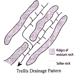
(i) Trellis Drainage Pattern: As the river flows along a strike valley, smaller tributaries feed into it from the steep slopes on the sides of mountains. They are formed by consequent stream which follows regional slope and geological structure. Trellis drainage is characteristic of folded mountains, such as the Appalachian Mountains in
North America and in the north part of Trinidad.
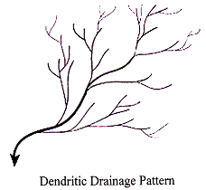
(ii) Dendritic Drainage Pattern: The tree like pattern formed by the river as they flow is called as dendritic drainage pattern.
(iii) Rectangular Drainage Pattern: This type of pattern is formed when streams from two directions of joining at approximately right angles.
Rectangular drainage develops on rocks that are of approximately uniform resistance to erosion.
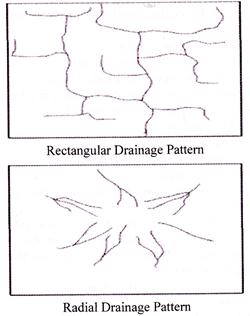
(iv) Radial Drainage Pattern: When the streams radiate outwards from a central high point they form radial drainage pattern.
(v) Centripetal Drainage Pattern: When the streams flow towards a common depression they form centripetal force. This pattern is opposite of radial pattern.
(vi) Annular Drainage Pattern: The tributaries of consequent stream develop in a form of circle. This pattern is found over a mature and dissected dome mountain characterized by soft and hard rock alternatively. Angles of the streams meeting are both more and less than 90 degrees.
(vii) Barbed Drainage Pattern: It is formed when the tributaries of a river runs in the opposite direction to its master steam.
(viii) Herringbone Drainage Pattern: It is also known as rib pattern. It resembles the rib bones of human being (upper Jhelum, Tamar Kosi, upper Rapti and left bank of Gandak).
(ix) Parallel Drainage Pattern: It follows the regional slope and develops on uniformly sloping landmass.
The western coastal plain of India has such type of pattern.


You need to login to perform this action.
You will be redirected in
3 sec

