Introduction to Disaster Risk Management Understanding Disaster Mitigation
Community contingency funds: Disaster management puts aside a certain amount of money contributed by the community for use in emergencies.
Incentives and financial framework: Government grants or subsidies help to persuade commercial and other instructions to include mitigation measures in building and construction work.
Recovery: Measures which help disaster affected communities to restore emotional and economic well-being.
Slow onset hazards: Famine, drought, pest infestation, environmental degradation, desertification.
Industrial/technological disasters: Fire, explosion, chemical leakage/spillage, system failures.
Multi-hazard zones: Some areas are exposed to many hazards like coastal areas may experience floods, cyclones, earthquakes etc.
Tremor: Shaking of the earth's surface.
Epicenter: The place on the surface of the earth which is the center of the earthquake.
Richter scale: A scale which measures the magnitude of an earthquake.
Modified Mercalli Scale: A scale which measures the intensity of an earthquake.
Seismic zone: An area prone to earthquakes.
Seismologists: Scientists who study all aspects of earthquake.
Tsunami: A seismic sea wave or destructive tidal wave generated by underwater earthquake.
Cyclone: It is a storm and develops when a low pressure area in the atmosphere is surrounded by high pressure. Cyclones are associated with strong winds, heavy rains, tidal waves etc.
Hurricane: Storms with violent winds in the Atlantic ocean.
DWS: Disaster Warning System.
Typhoons: Storms like cyclones in the Pacific Ocean.
Willie Willie: Storms like cyclones in Australia.
Storm Surge: Seawaves water is pushed towards the shore by the force of winds swirling around cyclone.
Arid region: Areas which receive scanty rainfall, dry areas with very little vegetation.
Droughts: Acuter shortage of water, food, fodder due to scanty rainfall and scarcity of water.
Water stress: When the demand for water exceeds the available amount or when poor quality restricts its use.
Aquifer: Water bearing formation that stores or transmits water, such as wells, tube-wells and springs. These water bearing formations are capable of providing water in sufficient quantity.
Drip-irrigation: A common irrigation method where pipes/tubes filled with water slowly drip into crops. Less water is lost to evaporation and is useful in dry areas.
Groundwater: Water obtained from the depth of the earth, of more than 15 m. It is obtained through tube-wells. It is recharged by rainfall.
Rainwater harvesting: It is a technique of recharging and increasing of underground water by storing rain water and allowing it to percolate in the earth’s surface.
Standard Meridian. Longitude which passes, approximately centrally through a country and is used to record local standard time.
Sub-continent. A big piece of land separated from the main continent by a bold land barrier.
South Asian Association for Regional Co-operation. It is an association of seven South Asian Nations—India, Pakistan, Bangladesh, Nepal, Bhutan, Sri Lanka and Maldives.
Tropic of Cancer. North latitude. Rays of sun fall vertically on it on 21st June.
Tropic of Capricorn. South latitude. Rays of sun fall vertically on it on 22nd December.
latitude. It divides the earth into two equal parts, northern and southern hemispheres.
Half a sphere. The earth is divided into the northern and southern hemispheres by an equator.
It is the angular distance, north or south from the equator, of a point on the earth's surface. The equator is, and points can therefore be measured in degrees, south or north of this line. The imaginary lines drawn on a map or globe are the lines of longitude.
It is the angular distance of a point measured on the earth's surface to the east or west of a 'central' reference point. The reference point in this case is the plane created by a meridian going through Greenwich in England. It is Meridian.
A piece of land which is surrounded by water on two sides. It is connected to the rest of the land mass by a narrow neck of land, e.g., Indian Peninsular and Malaysian Peninsula.
A piece of land surrounded by seas on all sides, e.g., Sri lanka, Lakshadweep.
Tropical Zone. The earth's surface between Tropic of Cancer and Tropic of Capricorn.
Sub-Tropical Zone. The term used to describe those zones near to but outside the tropics.
They stretch from the Tropic of Cancer and Capricorn to north or south of the Equator.
A narrow stretch of sea linking two large seas, e.g., Pal strait, English channel.
Greenwich Meridian. An imaginary circle that cuts the poles and goes over the earth's surface through Greenwich in England, it is numbered as It was based on Greenwich observatory near London. There is a time difference of one hour when travelling East or West from Greenwich Meridian. ( Prime Meridian)
A clearly defined mountainous area that has a uniform appearance and geology and is distinct from the surrounding area.
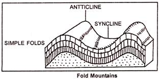
Folds and Faults. Geological features developed through tectonic activity. Folds are produced when rock layers undergo compression resulting in buckling and folding of the rocks.
Faults are caused by brittle deformation. Rocks are moved, or displaced and cracks may appear.
A steep slope on the outside of a meander, a steep headland.
A river bank that has been built up above the level of the surrounding Flood Plain.
Force originating within the earth and responsible for bringing widespread changes in the landform features.
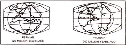
Million of years ago there was a big super continent (large land mass) located in the southern hemisphere. Today it includes South America, Africa, Australia and Antarctica.
Eurasian plate. It is a large land mass in the Northern hemisphere also known as Angara land.
Tethys Sea. Shallow sea, located between two large land masses Angara land (Eurasian plate) and Gondwana land.
10. Fold mountains. Mountains formed due to the folding of the earth's crust, e.g., Himalayas.
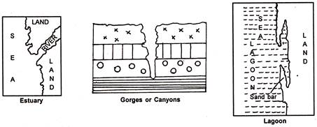
11. Estuary. A funnel shaped mouth of the river. The river joins the sea directly without depositing silt. It does not form delta, e.g., Tapi and Narmada rivers.
12. Lagoons. Shallow salt water lakes almost cut off from the sea by a line of rocks (sand bars) sub-merged in the sea.
13. Gorge/canyon. Formed due to erosional activity of a river. It is an I-shaped valley having steep vertical walls on either side of the river.
14. Convectional currents in the mantle. Heat from within the earth makes the molten rock in the mantle rise, forming convectional currents. Rising currents tear the crust apart, dividing it into large fragments called tectonic plates.
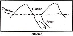
15. Glacier. A slow moving river of snow and ice formed above the snowline.
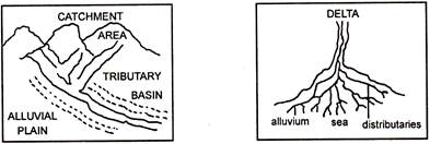
16. Basin. An area drained by river and its tributaries.
17. Catchment Area. The region which drains all the rain-water into a river or tributary.
18. Delta. An area of low, flat land-shaped like a triangle, where a river splits and forms several distributaries before entering the sea. This area contains large deposit of silt-alluvial soil.
19. Alluvial fans. Himalayan rivers, flowing down the slopes of the mountains, reach the plains and form more...
Near Mansarowar Lake in Tibet at a height of 5080 metres
2880
3,21,290
(a) Zaskar, Astar, Dras, Shylok, Nulora, Gilgit, Hunza join in Kashmir(b) The collective waters of the Punjab rivers : Satluj, Ravi, Beas, Chenab and Jhelum join Indus in Pakistan.
Watershed. A higher ground (upland) separating two adjoining drainage systems or a river basin.
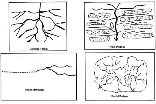
Dendritic drainage. It is a river system in which a number of streams (tributaries) join the main river to form a pattern that looks like a tree with its spreading branches.
Trellis drainage. It is a river system in which the main river is joined by (streams tributaries), flowing in sub-parallel valleys. The streams form a rectangular or trellis pattern, e.g., River Narmada basin in India.
Radial drainage. It is a river system in which streams flow outwards in different directions from central dome-shaped watershed. It is formed in areas of conical hills.
Inland drainage. When the rivers do not have sufficient water to reach a sea or an ocean but instead flow into a lake or end up in an arid region, it forms inland drainage. The Aksai Chin area in Ladakh is an Inland drainage.
6.Gorge. It is a deep river valley with steep walls. It is much deeper than it is wide. It is cut by river action in areas of low rainfall where the river has a plentiful supply of water from a source higher up. The lack of rainfall means that there is little erosion of the rocky sides of the river valley.
7. Braided river. Rivers carrying large amount of silt form silt islands, e.g., Brahmaputra river.
8. Estuary. A partially enclosed stretch of water that is subjected to marine tides and fresh water drainage from land. River enters into the sea depositing all the silt into the ocean and does not form delta.
9. Perennial rivers. Rivers which are snow-fed and have constant volume of water throughout the year, e.g., Ganga, Yamuna, Indus, etc.
10. Rain basin. An area drained by a single river with its tributaries is known as a river basin. e.g.. River Ganga with its tributaries flows through Haridwar, Varanasi and Patna etc. The area is called river basin.
11. Peninsula rivers. All the rivers flowing in the Deccan plateau, e.g., Mahanadi, Krishna, Godavari etc. are Peninsula rivers. They are non-perennial because their flow is mainly dependent on rainfall. They are rain-fed and therefore fluctuate in volume.
12. Himalayan rivers. These rivers originate in the Himalayas. They are snow-fed. The volume of water does not fluctuate much, hence they are perennial rivers, e.g., Yamuna, Ganga, Kosi, etc.
13. Lagoons. Shallow salt water lakes almost cut off from the sea by a beach or reef, e.g., Lake Chilika in Orissa and Lake Pulicat in Tamil Nadu. Malabar coast is studded with number of lagoons.
14. Delta. A roughly triangular area of sediments formed at the mouth of a river. It contains large quantity of alluvium. It is favourable for doing agriculture. There are number of distributaries in the. delta more...
Monsoon. It is derived from an Arabic word "mausam" meaning season. Monsoon refers to the seasonal reversal in the wind direction throughout the year.
Climate. It is the average weather conditions of a place over a long period of time, about 30-40 years.
Continental climate. It is experienced in the interior of the continent It is very hot in summer and very cold in winter, e.g., Delhi.
Cyclones. They have a low pressure at the centre and a circular wind motion. A eyelone is often accompanied by heavy rain.
Range of temperature. It is the difference between maximum and minimum temperatures.
Dry spelles. It refers to the rainless days during the monsoon season.
Jet Streams. They are fast flowing cold air currents in a narrow zone in the upper atmosphere.
Isobar. It is an imaginary line, drawn on the map, to join places having the same pressure above sea level. It is measured in millibar (mb).
Isohyet. It is an imaginary line, drawn on the map, to join places having the same amount of rainfall, e.g., mm or cm.
Isotherm It is an imaginary line, drawn on the map, joining all Ifae places having the same temperature above sea level, or .
Leeward side. It is the rain shadow area and lies on the side which is away from the direction of the wind, e.g., Deccan Plateau is on the leeward side of the Western gnats.
Loo. Hot and dry winds blow in the afternoon and very often continue even up to mid-night in summer. These winds are locally known as loo.
Maritime Climate. It is experienced in coastal areas. It has cool summers and mild winters e.g., Mumbai.
Windward. Slopes facing the wind direction. It receives heavy rains. Western ghats get heavy rain from Arabian Sea branch of the south-west monsoons.
Breaking of monsoon. Sudden approach of the moisture laden winds is associated with violent thunder and lightning. This is known as "break" or "burst" of the monsoons. The monsoon first "break" on the south-west Coast of India around 1 st June.
Monsoon trough. It refers to the intense low pressure area, which develops over north-western parts of the country extending from Thar Desert to Chota Nagpur Plateau.
Transitional period. It is the period between two seasons.
Vagaries of the monsoons refers to the uncertainties of the monsoons.
Trade winds. They are the prevailing easterly winds, which blow from the sub-tropical high pressure belt to equatorial low pressure.
Warm Current. Streams of water flowing in the surface or at sub-surface levels of oceans.
Warm currents are those which flow from warmer to cooler regions, e.g., warm Atlantic drift.
Cold current. Stream of water flowing on the surface or at sub-surface levels of oceans.
Cold currents flow from colder to warmer regions, e.g., Labrador current.
Western disturbances. Are the shallow cyclonic disturbances, which originate over the Mediterranean Sea. In India they more...