Minerals and Rocks
The earth is composed of various kinds of elements. These elements are in solid form in the outer layer of the earth and in hot and molten form in the interior.
About 98 per cent of the total crust of the earth is composed of eight elements like oxygen, silicon, aluminium, iron, calcium, sodium, potassium and magnesium (Table 5.1), and the rest is constituted by titanium, hydrogen, phosphorous, manganese, sulphur, carbon, nickel and other elements.
Table 5.1: The Major Elements of the Earth's Crust
Geomorphic Processes
After learning about how the earth was born, how it evolved its crust and other A inner layers, how its crustal plates moved and are moving, and other information on earthquakes, the forms of volcanism and about the rocks and minerals the crust is composed of, it is time to know in detail about the surface of the earth on which we live. Let us start with this question.
Why is the surface of the earth uneven?
First of all, the earth's crust is dynamic. You are well aware that it has moved and moves vertically and horizontally. Of course, it moved a bit faster in the past than the rate at which it is moving now. The differences in the internal forces operating from within the earth which built up the crust have been responsible for the variations in the outer surface of the crust. The earth's surface is being continuously subjected to external forces induced basically by energy (sunlight). Of course, the internal forces are still active though with different intensities. That means, the earth's surface is being continuously subjected to by external forces originating within the earth's atmosphere and by internal forces from within the earth.
The external forces are known as exogenic forces and the internal forces are known as endogenic forces. The actions of exogenic forces result in wearing down (degradation) of relief/elevations and filling up (aggradation) of basins/depressions, on the earth's surface. The phenomenon of wearing down of relief variations of the surface of the earth through erosion is known as gradation. The endogenic forces continuously elevate or build up parts of the earth's surface and hence the exogenic processes fail to even out the relief variations of the surface of the earth. So, variations remain as long as the opposing actions of exogenic and endogenic forces continue. In general terms, the endogenic forces are mainly land building forces and the exogenic processes are mainly land wearing forces. The surface of the earth is sensitive. Humans depend on it for their sustenance and have been using it extensively and intensively. So, it is essential to understand its nature in order to use it effectively without disturbing its balance and diminishing its potential for the future. Almost all organisms contribute to sustain the earth's environment. However, humans have caused over use of resources. Use we must, but must also leave it potential enough to sustain life through the future. Most of the surface of the earth had and has been shaped over very long periods of time (hundreds and thousands of years) and because of its use and misuse by humans its potential is being diminished at a fast rate. If the processes which shaped and are shaping the surface of the earth into varieties of forms (shapes) and the nature of materials of which it is composed of, are understood, precautions can be taken to minimise the detrimental more...
Landforms and Their Evolution
After weathering processes have had their actions on the earth materials making up the surface of the earth, the geomorphic agents like running water, ground water, wind, glaciers, waves perform erosion. It is already known to you that erosion causes changes on the surface of the earth. Deposition follows erosion and because of deposition too, changes occur on the surface of the earth.
As this chapter deals with landforms and their evolution first start with the question, what is a landform? In simple words, small to medium tracts or parcels of the earth's surface are called landforms.
If landform is a small to medium sized part of the surface of the earth, what is a landscape?
Several related landforms together make up landscapes, (large tracts of earth's surface). Each landform has its own physical shape, size, materials and is a result of the action of certain geomorphic processes and agent(s). Actions of most of the geomorphic processes and agents are slow, and hence the results take a long time to take shape. Every landform has beginning. Landforms once formed may change in their shape, size and nature slowly or fast due to continued action of geomorphic processes and agents.
Due to changes in climatic conditions and vertical or horizontal movements of and- masses, either the intensity of processes or the processes themselves might change leading to new modifications in the landforms. Evolution here implies stages of transformation of either a part of the earth's surface from one landform into another or transformation of individual landforms after they are once formed. That means, each and every landform has a history of development and changes through time. A landmass passes through stages of development somewhat comparable to the stages of life - youth, mature and old age.
What are the two important aspects of the evolution of landforms?
The evolutionary history of the continually changing surface of the earth is essential to be understood in order to use it effectively without disturbing its balance and diminishing its potential for the future. Geomorphology deals with the reconstruction of the history of the surface of the earth through a study of its forms, the materials of which it is made up of and the processes that shape it.
Changes on the surface of the earth owe mostly to erosion by various geomorphic agents. Of course, the process of deposition too, by covering the land surfaces and filling the basins, valleys or depressions, brings changes in the surface of the land. Deposition follows erosion and the depositional surfaces too are ultimately subjected to erosion. Running water, ground-water, glaciers, wind and waves are powerful erosional and depositional agents shaping and changing the surface of the earth aided by weathering and mass wasting processes. These geomorphic agents acting over long periods of time produce systematic changes leading to sequential development of landforms. Each geomorphic agent produces its more...
Composition and Structure of Atmosphere
Can a person live without air? We eat food two - three times a day and drink water more frequently but breathe every few seconds. Air is essential to the survival of all organisms. Some organisms like humans may survive for some time without food and water but can't survive even a few minutes without breathing air. That shows the reason why we should understand the atmosphere in greater detail. Atmosphere is a mixture of different gases and it envelopes the earth all round. It contains life-giving gases like oxygen for humans and animals and carbon dioxide for plants. The air is an integral part of the earth's mass and 99 per cent of the total mass of the atmosphere is confined to the height of 32 km from the earth's surface. The air is colourless and odourless and can be felt only when it blows as wind. Can you imagine what will happen to us in the absence of ozone in the atmosphere?
Composition of the Atmosphere
The atmosphere is composed of gases, water vapour and dust particles. Table 8.1 shows details of various gases in the air, particularly in the lower atmosphere. The proportion of gases changes in the higher layers of the atmosphere in such a way that oxygen will be almost in negligible quantity at the height of 120 km. Similarly, carbon dioxide and water vapour are found only up to 90 km from the surface of the earth.
Table 8.1 : Permanent Gases of the Atmosphere
Solar Radiation, Heat Balance and Temperature
Do you feel air around you? Do you know that we live at the bottom of a huge pile of air? We inhale and exhale but we feel the air when it is in motion. It means air in motion is wind. You have already learnt about the fact that earth is surrounded by air all around. This envelop of air is atmosphere which is composed of numerous gases. These gases support life over the earth's surface.
The earth receives almost all of its energy from the sun. The earth in turn radiates back to space the energy received from the sun. As a result, the earth neither warms up nor does it get cooled over a period of time. Thus, the amount of heat received by different parts of the earth is not the same. This variation causes pressure differences in the atmosphere. This leads to transfer of heat from one region to the other by winds. This chapter explains the process of heating and cooling of the atmosphere and the resultant temperature distribution over the earth's surface.
Solar Radiation
The earth's surface receives most of its energy in short wavelengths. The energy received by the earth is known as incoming solar radiation which in short is termed as insolation.
As the earth is a geoid resembling a sphere, the sun's rays fall obliquely at the top of the atmosphere and the earth intercepts a very small portion of the sun's energy. On an average the earth receives 1.94 calories per sq. cm per minute at the top of its atmosphere. The solar output received at the top of the atmosphere vanes slightly in a year due to the variations in the distance between the earth and the sun. During its revolution around the sun, the earth is farthest from the sun (152 million km on 4th July). This position of the earth is called aphelion. On 3rd January, the earth is the nearest to the sun (147 million km). This position is called perihelion. Therefore, the annual insolation received by the earth on 3rd January is slightly more than the amount received on 4th July. However, the effect of this variation in the solar output is masked by other factors like the distribution of land and sea and the atmospheric circulation. Hence, this variation in the solar output does not have great effect on daily weather changes on the surface of the earth.
Variability of Insolation at the Surface of the Earth
The amount and the intensity of insolation vary during a day, in a season and in ayear. The factors that cause these variations in insolation are:
(i) the rotation of earth on its axis;
(ii) the angle of inclination of the sun's rays;
(iii) the length of the day;
(iv) the transparency of the atmosphere;
(v) the configuration of land in terms of its more...
Atmospheric Circulation and Weather Systems
Earlier Chapter 9 described the uneven distribution of temperature over the surface of the earth. Air expands when heated and gets compressed when cooled. This results in variations in the atmospheric pressure. The result is that it causes the movement of air from high pressure to low pressure, setting the air in motion. You already know that air in horizontal motion is wind. Atmospheric pressure also determines when the air will rise or sink. The wind redistributes the heat and moisture across the planet, thereby, maintaining a constant temperature for the planet as a whole. The vertical rising of moist air cools it down to form the clouds and bring precipitation. This chapter has been devoted to explain the causes of pressure differences, the forces that control the atmospheric circulation, the turbulent pattern of wind, the formation of air masses, the disturbed weather when air masses interact with each other and the phenomenon of violent tropical storms.
Atmospheric Pressure
Do you realise that our body is subjected to a lot of air pressure. As one moves up the air gets verified and one feels breathless.
The weight of a column of air contained in a unit area from the mean sea level to the top of the atmosphere is called the atmospheric pressure. The atmospheric pressure is expressed in units of mb and Pascal’s. The widely used unit is kilo Pascal written as hPa.
At sea level the average atmospheric pressure is 1,013.2 mb or 1,013.2 hPa. Due to gravity the air at the surface is denser and hence has higher pressure. Air pressure is measured with the help of a mercury barometer or the aneroid barometer. Consult your book. Practical Work in Geography - Part I (NCERT, 2006) and leam about these instruments. The pressure decreases with height. At any elevation it varies from place to place and its variation is the primary cause of air motion, i.e. wind which moves from high pressure areas to low pressure areas.
Vertical Variation of Pressure
In the lower atmosphere the pressure decreases rapidly with height. The decrease amounts to about 1 mb for each 10m increase in elevation. It does not always decrease at the same rate. Table 10.1 gives the average pressure and temperature at selected levels of elevation for a standard atmosphere.
Table 10.1: Standard Pressure and Temperature at
Water in the Atmosphere
You have already learnt that the air contains water vapour. It varies from zero to four per cent by volume of the atmosphere and plays an important role in the weather phenomena. Water is present in the atmosphere in three forms namely - gaseous, liquid and solid. The moisture in the atmosphere is derived from water bodies through evaporation and from plants through transpiration. Thus, there is a continuous exchange of water between the atmosphere, the oceans and the continents through the processes of evaporation, transpiration, condensation and precipitation.
Water vapour present in the air is known as humidity. It is expressed quantitatively in different ways. The actual amount of the water vapour present in the atmosphere is known as the absolute humidity. It is the weight of water vapour per unit volume of air and is expressed in terms of grams per cubic metre. The ability of the air to hold water vapour depends entirely on its temperature. The absolute humidity differs from place to place on the surface of the earth. The percentage of moisture present in the atmosphere as compared to its full capacity at a given temperature is known as the relative humidity. With the change of air temperature, the capacity to retain moisture increases or decreases and the relative humidity is also affected. It is greater over the oceans and least over the continents.
The air containing moisture to its full capacity at a given temperature is said to be saturated. It means that the air at the given temperature is incapable of holding any additional amount of moisture at that stage. The temperature at which saturation occurs in a given sample of air is known as dew point.
Evaporation and Condensation
The amount of water vapour in the atmosphere s added or withdrawn due to evaporation and condensation respectively. Evaporation is a process by which water is transformed from liquid to gaseous state. Heat is the main cause for evaporation. The temperature at which the water starts evaporating is referred to as the latent heat of vapourisation.
Increase in temperature increases water absorption and retention capacity of the given parcel of air. Similarly, if the moisture content is low, air has a potentiality of absorbing and retaining moisture. Movement of air replaces the saturated layer with the unsaturated layer. Hence, the greater the movement of air, the greater is the evaporation.
The transformation of water vapour into water is called condensation. Condensation is caused by the loss of heat. When moist air is cooled, it may reach a level when its capacity to hold water vapour ceases. Then, the excess water vapour condenses into liquid form. If it directly condenses into solid form, it is known as sublimation. In free air, condensation results from cooling around very small particles termed as hygroscopic condensation nuclei. Particles of dust, smoke and salt from the ocean are particularly good nuclei more...
World Climate and Climate Change
The world climate can be studied by organising information and data on climate and synthesising them in smaller units for easy understanding, description and analysis. Three broad approaches have been adopted for classifying climate. They are empirical, genetic and applied. Empirical classification is based on observed data, particularly on temperature and precipitation. Genetic classification attempts to organise climates according to their causes. Applied classification is for specific purpose.
Koeppen's Scheme of Classification of Climate
The most widely used classification of climate is the empirical climate classification scheme developed by V. Koeppen. Koeppen identified a close relationship between the distribution of vegetation and climate. He selected certain values of temperature and precipitation and related them to the distribution of vegetation and used these values for classifying the climates. It is an empirical classification based on mean annual and mean monthly temperature and precipitation data. He introduced the use of capital and small letters to designate climatic groups and types. Although developed in 1918 and modified over a period of time, Koeppen's scheme is still popular and in use.
Koeppen recognised five major climatic groups, four of them are based on temperature and one on precipitation. Table 12.1 lists the climatic groups and their characteristics according to Koeppen. The capital letters : A, C, D and E delineate humid climates and B dry climates.
The climatic groups are subdivided into types, designated by small letters, based on seasonality of precipitation and temperature characteristics. The seasons of dryness are indicated by the small letters : f, m, w and s, where f corresponds to no dry season,
Table 12.1: Climates Groups According to Koeppen
Group
Characteristics
A - Tropical
B - Dry Climates
C - Warm Temperate
D - Cold Snow Forest Climates
E - Cold Climates
H - High Land
Average temperature of the coldest month is \[18{}^\circ C\]or higher
Potential evaporation exceeds precipitation
The average temperature of the coldest month of the (Mid-latitude) climates years is higher than minus \[3{}^\circ C\]but below \[18{}^\circ C\]
The average temperature of the coldest month is minus \[3{}^\circ C\] or below
Average temperature for all months is below \[10{}^\circ C\]
Cold due to elevation
m - monsoon climate, w- winter dry season and s - summer dry season. The small letters a, b, c and d refer to the degree of severity of more...
Water (Oceans)
Can we think of life without water? It is said that the water is life. Water is an essential component of all life forms that exist over the surface of the earth. The creatures on the earth are lucky that it is a water planet, otherwise we all would have no existence. Water is a rare commodity in our solar system. There is no water on the sun or anywhere else in the solar system. The earth, fortunately has an abundant supply of water on its surface. Hence, our planet is called the 'Blue Planet'.
Hydrological Cycle
Water is a cyclic resource. It can be used and re-used. Water also undergoes a cycle from the ocean to land and land to ocean. The hydrological cycle describes the movement of water on, in, and above the earth. The water cycle has been working for billions of years and all the life on earth depends on it. Next to air, water is the most important element required for the existence of life on earth. The distribution of water on earth is quite uneven. Many locations have plenty of water while others have very limited quantity. The hydrological cycle, is the circulation of water within the earth's hydrosphere in different forms i.e. the liquid, solid and the gaseous phases.
It also refers to the continuous exchange of water between the oceans, atmosphere, land surface and subsurface and the organisms.
Table 13.1 shows distribution of water on the surface of the earth. About 71 per cent of the planetary water is found in the oceans. The remaining is held as freshwater in glaciers and icecaps, groundwater sources, lakes, soil moisture, atmosphere, streams and within life. Nearly 59 per cent of the water that falls on land returns to the atmosphere through evaporation from over the oceans as well as from other places. The remainder runs-off on the surface, infiltrates into the ground or a part of it becomes glacier (Figure 13.1).
Table 13.1 Water on the Earth’s surface
Movements of Ocean Water
The ocean water is dynamic. Its physical characteristics like temperature, salinity, density and the external forces like of the sun, moon and the winds influence the movement of ocean water. The horizontal and vertical motions are common in ocean water bodies. The horizontal motion refers to the ocean currents and waves. The vertical motion refers to tides. Ocean currents are the continuous flow of huge amount of water in a definite direction while the waves are the horizontal motion of water. Water moves ahead from one place to another through ocean currents while the water in the waves does not move, but the wave trains move ahead. The vertical motion refers to the rise and fall of water in the oceans and seas. Due to attraction of the sun and the moon, the ocean water is raised up and falls down twice a day. The upwelling of cold water from subsurface and the sinking of surface water are also forms of vertical motion of ocean water.
Waves
Waves are actually the energy, not the water as such, which moves across the ocean surface. Water particles only travel in a small circle as a wave passes. Wind provides energy to the waves. Wind causes waves to travel in the ocean and the energy is released on shorelines. The motion of the surface water seldom affects the stagnant deep bottom water of the oceans. As a wave approaches the beach, it slows down.
This is due to the friction occurring between the dynamic water and the sea floor. And, when the depth of water is less than half the wavelength of the wave, the wave breaks. The largest waves are found in the open oceans. Waves continue to grow larger as they move and absorb energy from the wind.
Most of the waves are caused by the wind driving against water. When a breeze of two knots or less blows over calm water, small ripples form and grow as the wind speed increases until white caps appear in the breaking waves. Waves may travel thousands of km before rolling ashore, breaking and dissolving as surf.
A wave's size and shape reveal its origin. Steep waves are fairly young ones and are probably formed by local wind. Slow and steady waves originate from faraway places, possibly from another hemisphere. The maximum wave height is determined by the strength of the wind, i.e. how long it blows and the area over which it blows in a single direction.
Waves travel because wind pushes the water body in its course while gravity pulls the crests of the waves downward. The falling water pushes the former troughs upward, and the wave moves to a new position (Figure 14.1). The actual motion of the water beneath the waves is circular. It indicates that things are carried up and forward as the wave approaches, and down and more...


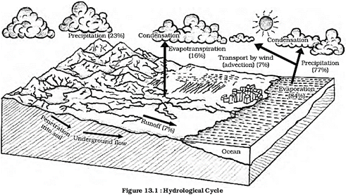 Table 13.1 Water on the Earth’s surface


