Current Affairs 6th Class

  Government   Summary   1.            Government is an institution which maintains law and order. 2.            A monarchy is a form of government with a monarch, i.e. a king or queen at the head. 3.            A dictatorship is a government that is ruled by a person without the collective approval of the people. 4.            Democracy is the most popular form of government today. In a democracy, people choose their representatives through elections. 5.            Freedom and equality are the most important elements of a democracy. 6.            There are three levels at which the government in India functions: the central government, the state government, and the local government. 7.            In India, the law-making organ of the government is called the Legislature; the organ that executes various functions is called the Executive; and the organ that ensures that we obey these laws is called the Judiciary. 8.            The government builds the infrastructure of the country, looks after the welfare of the people, protects the state, upholds law and order, and maintains good relations with other countries.   Government What happens when a teacher is not present in the classroom? Students tend to get indisciplined. Right? One student may get up from the seat and start playing with paper planes; another may pull out the lunch box and start eating from it; a student sitting behind may demand for a bite and a fight may ensue. There is total confusion and chaos in the classroom. Then, the teacher arrives and there is pin-drop silence. You must have experienced this. So the teacher appoints a monitor to maintain order in class in her absence. The monitor is one amongst you. The other students need to obey the monitor, or else get punished.     
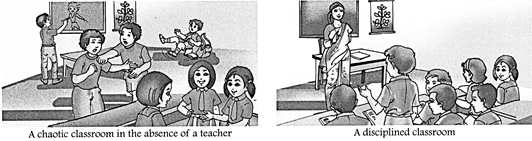
What is one thing that is common in everyday newspaper headlines? It is the term 'government', written as Govt in short form. You have heard this word many times from the mouth of elders, over the radio and on television. You have also read it in the newspapers and magazines. What is a government? What does it do? Why do we need a government? Why does our country have a government? Who makes up the government? We will more...
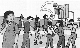
  Discrimination-Inequality, Stereotypes and Prejudice   Summary   1.            Discrimination means treating a group of people less favourable than others because of factors like skin colour, gender, nationality, religion , culture, status and disability. 2.            Forming rigid ideas about a certain group and being judgemental about them results in stereotypes. 3.            Prejudice means to ?pre-judge? someone. 4.            Stereotypes and prejudices lead to discrimination. 5.            We should respect one another and accept our differences. Tolerance helps us to learn about different cultures, new ideas, etc. 6.            The Constitution of India guarantees equality on the grounds of religion, caste, creed, etc.   Introduction When you look around and you see people different from you, what do you think about the differences? Why are some people so different from you? Do you treat them differently?   In the previous chapter, we viewed the positive aspect of diversity. However, diversity has a dark side too. In this chapter, we will find out how diversity impacts us negatively. Not all appreciate diversity. When a person thinks that only one particular way is the best and the right way to do a thing, he ends up not respecting people who may prefer to do things differently. Such people may rarely associate with the members of certain groups. Now assess the situation in the picture.     Discuss ? Why do you think the child is not allowed to play with the rest? ? What do you think about this kind of behaviour? ? Can you recollect any such incident where someone was treated this way?   WHAT IS DISCRIMINATION? Diversity exists naturally while discrimination is man-made. Discrimination refers to treating a group of people less favourably than others. This may be because of their skin colour, gender, nationality, religion, culture, status, disability, age and many more aspects. In most cases, people who are discriminated against are judged as 'inferior'. Some are called hurtful names, some are not allowed to participate in events, some are excluded from jobs and clubs, some are attacked and beaten; some are not given promotions or unfairly paid less for doing the same work; and some homes or places of worship are more...

  Diversity   Summary   1.            Diversity is the state of being different. It adds variety and enjoyment to our life. 2.            We differ from one another in physical appearance, food habits, religious beliefs, ideologies, dresses, etc. 3.            Diversity exists in physical appearance, gender, economic status, and social and cultural life. 4.            Diversity encourages us to adapt to new people, places and surroundings, and become more tolerant and broad-minded towards our differences. 5.            India exhibits diversity in terms of geographical features, religion, language, dress and food. 6.            There is unity in India in spite of diversity.     Introduction The great German indologist Max Muller said? If I were to look over the whole world to find out the country most richly endowed with all the wealth, power and beauty that nature can bestow ? in some parts a very paradise on earth- I should point to India.?   This statement shows that India is a land of diversity which enhances the beauty of this country.   WHAT IS 'DIVERSITY'? As you sit in your classroom, look around and observe each student. You will find that each student looks different from the other. Some are dark-skinned while some are fair; some have curly hair, and some have straight hair; some are tall, others are short; some are fat while some are thin. You also differ in your habits and interests. Your friend might like to play basketball, but you would go for cricket. Your religious beliefs might differ as well. You might go to a temple to pray, but your friend would visit a church on the weekend.   At home also, you might find many differences between you and your\[sibling{{s}^{1}}\]. Your sister likes to wear jeans but you like a pair of shorts. She loves rice, you like chapatti; she is good at painting while you are a good dancer. Again in your building or street, there might be people from various places with their varied ways of dressing and food habits. Even the plants and animals around you show a wide variety; they are of different shapes, colours, sizes and show different behaviour. This is diversity. Diversity can thus be defined as the state or fact of being different and unique. Diversity can be in terms of gender? more...

  India-Climate, Natural Vegetation and Wildlife   Summary   1.            India?s climate is influenced by the Himalayas in the north and the seas surrounding its peninsula in the south. 2.            India hosts four major climatic types, ranging from the desert in the west, to the alpines with frozen peaks and glaciers in the northern mountains; from temperate sub-tropical type in the northern plains to the humid tropical regions supporting rain forests in the south-west and the island territories. 3.            The landmass has four seasons: winter (January and February), summer (March to May), monsoon (rainy) season (June to September), and retreating monsoon (October to December). 4.            India receives \[60%\] of its rainfall from the south-west monsoons. 5.            The north-east monsoons bring rain to the east coast of India; and tropical cyclones in September- October over the Bay of Bengal causing rain, storm and destruction along the eastern deltaic areas. 6.            In winter the north-west part of India receives rainfall from the westerly cyclones. 7.            The distribution of rainfall is not the same due to the various climatic factors. 8.            Our crops depend quite a lot on the monsoon rains. 9.            A great variation in the relief features and in the amount of rainfall have created a variety of vegetation and forests in India. 10.          The Deciduous and Temperate Forests are commercially important. Tropical Evergreen Forests are found in areas where rainfall is recorded as 300 centimetres and temperatures vary between \[25{}^\circ C\] and \[30{}^\circ C\]. Evergreen Forests have a close canopy, intermingled species and very little undergrowth. 11.          Deciduous Forests are found in areas where rainfall is from 100 to 200 centimetres. Deciduous trees shed their leaves in March and April and thus, conserve moisture. 12.          The Thorny Desert Vegetation grows in areas with rainfall less than 50 centimetres a year. The Desert Forests have trees with long taproots, small leaves and thorny branches. 13.          Tidal Forests grow in river deltas near the sea shore. Trees of Tidal Forests have stilt-like supporting roots that keep them still even during the high more...

  Our Country India-Location and Physical Features   Summary   1.            India is located in the Northern and the Eastern Hemisphere. 2.            India shares common boundaries with seven countries; Afghanistan, Pakistan, China, Nepal, Bhutan, Bangladesh and Myanmar. 3.            India has 29 states and 7 union territories, including the National Capital Territory of Delhi. 4.            For administrative purposes the states are further divided into districts and tehsils. 5.            To fix the standard time of India, the \[82.5{}^\circ E\] longitude has been taken as the standard meridian. 6.            India is a part of a subcontinent and can be divided into six distinct physical divisions - The Northern Mountain Wall, the Northern Plains, the Great Indian Desert, the Indian Plateau, the Coastal Plains and Islands. 7.            The Northern Mountain Wall mostly consists of the Himalayas with an arc-shaped chain of three parallel ranges - the Himadri, Himachal and Shiwalik. 8.            Towards the south of the Himalayas are the Northern Plains and to the west is the Great Indian Desert which extends into Pakistan. 9.            The plateaus of peninsular India are flanked by the mountain ranges of the Western and Eastern Ghats, and surrounded by the Coastal Plains. 10.          The Lakshadweep in the Arabian Sea and the Andaman and Nicobar Islands in the Bay of Bengal are also parts of India.   India is a country of vast geographical expanse in South Asia. It is set apart from the rest of Asia by the lofty wall of the Himalayas in its north. The southern part is surrounded by water and this makes it a peninsula. Three large bodies of water that surround the Indian peninsula are the Arabian Sea in the West, the Bay of Bengal in the East and the Indian Ocean in the South, making it distinctly recognisable on the globe. India is the seventh largest country in the world after Russia, Canada, China, USA, Brazil and Australia. It is the second most populous country in the world 1.28 billion in 2015 after China with a population of 1.37 billon in 2015.   INDIA?LOCATION, EXTENT AND NEIGHBOURS India is located in the Northern and Eastern Hemisphere. The Tropic of more...

  Major Landforms of the Earth   Summary   1.            The major landforms of the Earth are mountains, plateaus and plains. 2.            Erosion and deposition by water, wind and ice can create and destroy landforms. 3.            Motion along tectonic plate boundaries creates tall mountain belts, volcanic chains and valleys. 4.            Mountains are natural elevations of the Earth?s surface rising more or less abruptly from the surrounding land. 5.            Plains are broad/nearly level stretches of land that have no great changes in elevation. 6.            Plateaus are elevated, comparatively level expanses of land. They are rich in minerals.   Have you noticed that the Earthy surface is not the same everywhere? It is uneven and irregular. Sometimes you may find it even but there are high mountains and valleys as well. These are natural physical features of the Earth?s surface or the lithosphere, and are called landforms. In this chapter we shall study about how the Earth is being shaped by various forces into landforms. The Earth has an infinite variety of landforms. The three major types of landforms classified on the basis of their elevation (height above sea level), relief and slope are: ? mountains, ? plateaus and ? plains. Large, flat and mainly grassy areas are the plains. Hills are elevated land masses that are less than 300 metres above the sea level. Land with elevations more than 600 metres are called mountains. Plateaus are extensive, relatively flat uplands. Other landforms include valleys\[^{1}\], islands\[^{2}\] and canyons\[^{3}\].       
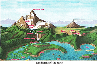
Large and small parts of our Earth are continuously changing and different landforms are being formed. There are two types of forces acting on the earth that bring about these changes?internal forces and external forces. The ground that you are standing on is slowly moving. Within the earth a continuous movement is taking place. The Earth's crust is made up of huge slabs called tectonic plates, which fit together like a jigsaw puzzle. Internal movements below the earth's surface cause collision of these plates against each other. Landforms like mountains, faults, valleys and volcanoes are   formed   this   way. Earthquakes also occur 'due to these movements. You will read about them later in the chapter. External forces include running H water, moving air, waves and tides at sea, and movement of H|B frozen ice more...

  The Four Great Realms of Our Planet Earth     Summary   1.            The earth is unique because of the three realms in it which sustain life - Lithosphere, Hydrosphere and Atmosphere.   2.            The lithosphere includes all landmasses - the continents and the ocean floors.   3.            There are seven continents into which the land surface is broadly divided. They are: Asia, Africa, North America, South America, Europe, Australasia and Antarctica.   4.            Three-fourths of the earth is water or hydrosphere which comprises of oceans, seas, rivers and ponds, and also includes groundwater, glaciers, ice caps and water vapour.   5.            The planet contains five oceans namely the Arctic, Atlantic, Indian, Pacific and Southern Oceans. Oceans and seas comprise 97 per cent of earth?s total water.   6.            The atmosphere is the envelope of gases that surrounds the earth and is divided into many concentric layers.                                                                                  7.            The troposphere is the nearest to the surface and contains half of the earth?s atmosphere. Weather occurs in this layer.   8.            The next layer is the stratosphere where jet aircraft fly. The ozone layer here absorbs the harmful rays emitted from the Sun.   9.            Meteors or rock fragments bum up in the mesosphere.   10.          The thermosphere is a hot layer where the space shuttles orbit.   11.          The exosphere is the upper limit of our atmosphere. The atmosphere merges into space above this layer.   12.          The biosphere is the zone of living organisms penetrating the lithosphere, hydrosphere and atmosphere.   13.          Human activities have disturbed the natural balance between the various elements of the biosphere leading to global warming, ozone depletion, more...

  Maps   Summary   1.            Maps are a representation of the whole or part of the earth on a flat surface. A cartographer uses different signs and symbols for showing different features on the map. Maps are drawn to scale. 2.            Directions on a map can be shown by using the points of a compass. 3.            Distances on a map can be measured using the Line Scale which gives the real distance between places on ground. 4.            Conventional symbols are simple drawings that show things (features) on maps. All maps have keys to explain the symbols used on them. 5.            On the basis of the scale of map-drawing, maps can be categorised as: (i) Small Scale Maps, or (ii) Large Scale Maps. 6.            On the basis of the function of a map or the features drawn on it, a map can be either a (i) Political Map, (ii) Physical Map, or a (iii) Thematic Map. 7.            Sketch Maps and Plans are different from a geographical map. A Sketch Map is a map which shows outlines of an area without providing enough details or using a scale. A Plan, however, is a representation of a small area with reduced measurement (scale) and much details.   Veneeta who studies is class VI in Delhi, was over enjoyed when her father told her about the trip they would be taking to Mumbai by train to meet her cousins. Then she ran to her globe to try and figure out all the places they would be passing through. But the globe did not show train routes. She then asked her father about it. He took her to his study room where he rolled out a thick canvas like paper. This is a map' he said. "Look at it carefully, you will find the answers to what you are looking for here. I shall also tell you about more features of maps." Her father started to explain...   What is a map? Perhaps, most people would not be able to give an appropriate answer. One of the reasons could be that there are many different types of maps used for different purposes.   MAPS All accurate maps have two things in common. They present 'a bird's eye view' of an area and they are all drawn to scale. Maps are a true graphical representation of more...

  Where in the World are We? Latitudes and Longitudes   Summary   1.            Lines of latitude are the horizontal lines that go around the globe. The equator runs through the middle and is the most important line of latitude. It makes an angle of \[0{}^\circ \] with the plane crossing through the middle of the earth. The equator is the main line of reference. 2.            Lines of longitude are the vertical lines on the globe. These lines join the North and South Poles. The Prime Meridian or \[0{}^\circ \] longitude is the main line of reference on the globe. 3.            While locating places on the globe or on maps, the latitude is always read first and then the longitude. 4.            Latitudes and longitudes are measured in degrees\[\,({}^\circ )\]. Each degree is divided into 60 smaller parts called minutes (?). 5.            Lines of latitude are parallel to each other. They decrease in length towards the poles. Longitudes, on   the other hand, are of the same length. The distance between the two longitudes reduces when they move towards the poles. At poles, they join one another. 6.            The important latitudes help us divide the earth into different Heat Zones or Climate Zones as different places on the earth receive different amounts of sunlight as per their latitudinal location. 7.            There is a direct relationship between the longitude of a place and the time of the place. There is a difference of time between the two consecutive longitudes, i.e. four (4) minutes. All places on a given meridian or longitude have the same local time. 8.            The local time of a place is bound to differ as per their territorial expanse over different longitudes. To avoid confusion of time, countries have a Standard (Central) Meridian. A country having much wider expanse can have more than one Standard Time or Time zones like U.S.A. 9.            The International Date Line is the \[180{}^\circ \] meridian. The day and date change on this line. This line is curved at several points to avoid confusion of days and dates in the same territory.   Piyush was standing on the Marina Beach, Chennai. Before him is a vast endless sea. Looking out at the horizon he began to wonder which lands lie more...

  Motions of the Earth   Summary   1.            Rotation of the Earth is the spinning of the Earth on its axis from west to east, resulting in the occurrence of day and night on the Earth. 2.            Revolution is the movement of the Earth around the Sun in a fixed elliptical orbit over a period of one year. 3.            The axis of the Earth is inclined at an angle of \[23.5{}^\circ \] from the vertical line and 66.5° from its orbital plane. 4.            The Earth?s revolution and the tilt of the earth?s axis, cause seasons on the Earth. 5.            The summer solstice in the Northern Hemisphere occurs on June 21, when the Sun is directly over the 6.            Tropic of Cancer. It results in longest day. 7.            The winter solstice in the Northern Hemisphere occurs on December 22, when the Sun is directly over the Tropic of Capricorn. It results in longest night 8.            Equinox occurs on March 21 and September 23, when the Sun is directly over the Equator and length of days and nights are equal in both the hemispheres.     The idea of moving around in space and viewing the wonders of the universe may excite you. But do you know, actually we all are space travellers. Our spaceship is the Planet Earth. It is constantly in motion spinning like a top on its axis. That is why we see the Sun rise and set, and day change into night. While rotating on its axis the Earth is also revolving around the Sun in a fixed path called orbit. Hence, we have change of seasons and different climates in different regions.   Earth has two types of motions?rotation and revolution.   ROTATION The spinning of the Earth on its axis from west to east is termed as the Earth's rotation. An axis is an imaginary line running through the middle of an object. The Earth's axis is not exactly vertical, but inclined at an angle of 23.5° from the vertical. It thus makes an angle of 66.5° with its orbital plane. The plane formed by the orbit is known as orbital plane. One rotation of the earth takes exactly 24 hours and is called more...


You need to login to perform this action.
You will be redirected in 3 sec spinner